
Still beaming after all these years – NASA’s Opportunity Mars rover.
Credit: NASA/JPL
Being the veteran Mars explorer it is, the Opportunity rover is wheeling toward a milestone-making investigation – inspecting a Martian gully up-close.
Opportunity is less than a mile from the first Martian gully visited by a spacecraft from Earth. It will investigate the gully for evidence of water or dry sediment flow.
In research to be presented at the 48th Lunar and Planetary Science Conference (LPSC) in March, JPL Mars investigators, Tim Parker and Matt Golombek and colleagues detail what’s perplexing about Martian gullies and their debatable origin.
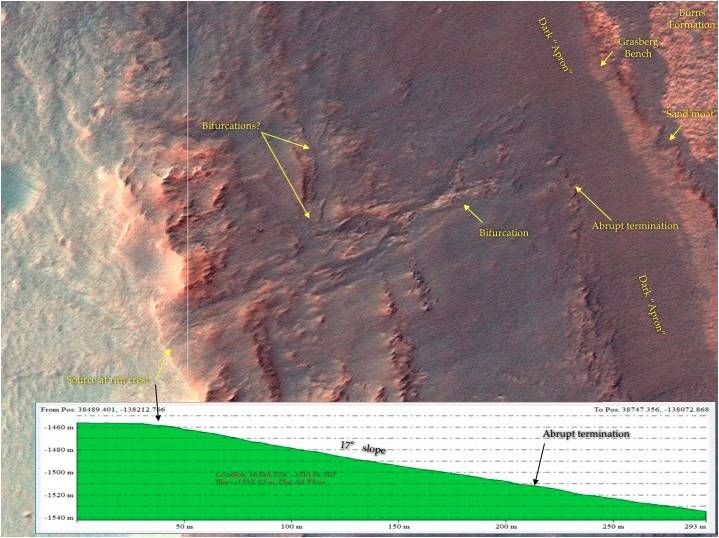
HiRISE map view of gully feature indicating source at Endeavour rim crest.
Credit: Parker, Golombek, et al.;Univ. of Arizona
Gully guessing
Do gullies indicate water flow? Debris flows? Brines?
If fluvial — produced by the action of a river or stream – do they derive from local springs, or small lakes or by precipitation?
Could they be formed by dry avalanches of fine, dry sediment that doesn’t require unusual, wet conditions?
Planetary soldier
Opportunity has been one busy planetary solider since it landed in Meridiani Planum on January 25, 2004 – now over 12 years ago. A dozen Earth years after its air-bag-cushioned touch down on the Red Planet, the rover is enduring its seventh Martian winter.
The gully feature that the robot is headed for was first identified in high resolution imaging science experiment (HiRISE) photos, a super-zoom camera system aboard NASA’s Mars Reconnaissance Orbiter. It was spotted by HiRISE images taken of the west rim of Endeavour crater in 2009, prior to Opportunity’s arrival at Cape York.
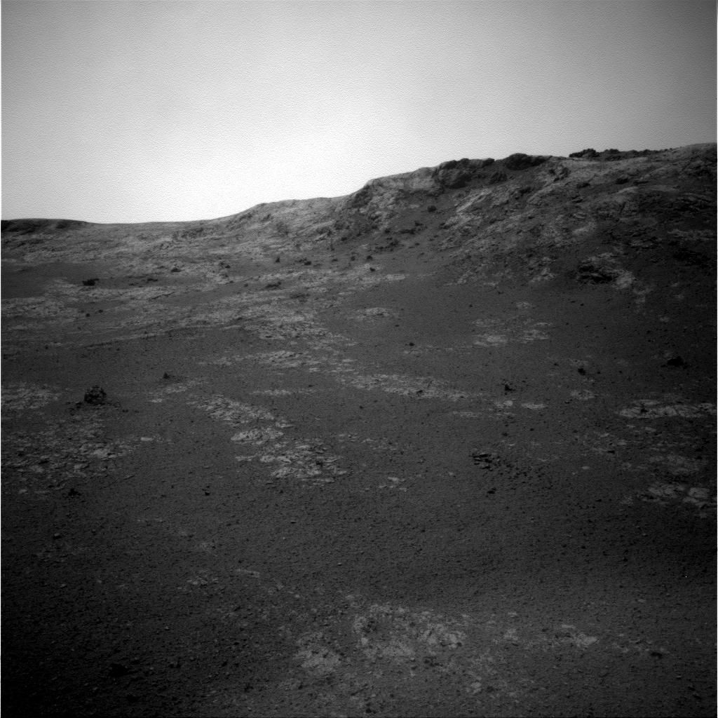
Recent image from Opportunity’s Navigation Camera on Sol 4633. As of Sol 4630 (Jan. 31, 2017), the rover’s total odometry is 27.30 miles (43.94 kilometers).
CREDIT: NASA/JPL-CALTECH/CORNELL
The gully has multiple branches that merge and split and appears to cut across the crest of the rim of Endeavour crater, although a bright narrow ridge may be at the gully head. The HiRISE topography shows the gully is on a 17 degree slope.
Useful observations
According to the LPSC research paper led by Parker and Golombek, the fact that the source of the gully is at the crest of the crater rim “may indicate spillover from a small lake to the west of the rim, and rapid draining through the channel into the crater interior.”
Alternatively, they also note that the gully head may have progressively retreated upslope, cannibalizing its own source area. Or a steeper source area at the crater rim may have been eroded away by eolian – wind — abrasion.
Once on location, the Opportunity rover can make a number of useful observations – be it Navcam stereo panoramas and Pancam color stereo shots — to address the origin of the gully.
How far to go?
Just how far is the rover from the gully?
In an email response to Inside Outer Space from Ray Arvidson of Washington University in Saint Louis, deputy principal investigator of the rover mission, it’s roughly 2,296 feet (700 meters) “as the crow flies,” maybe roughly 328 feet (100 meters) more “as Opportunity winds its way south along the Meridiani plains,” Arvidson said.
“Hope to get there within a few months to be able to explore the gully before winter sets in and mobility becomes limited,” Arvidson said.

