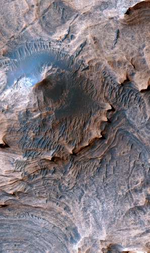
Enhanced color image of a hill in the Candor Colles region of Candor Chasma, Mars. Image is 1 km (0.62 miles) across.
Credit: USGS/NASA/JPL/University of Arizona
Want to stroll around on the Red Planet?
If so, you may put in your backpack a new U.S. Geological Survey (USGS) geologic map of Mars, billed as the most detailed representation of the Red Planet to date.
This new map provides geologic and structural information on layered sedimentary rocks at a scale comparable to what a field geologist would see on Earth, including a precise illustration of a portion of the “Grand Canyon of Mars,” or Valles Marineris.
The map provides new targets for continued scientific investigation of past potentially habitable environments on Mars.
The just released USGS geologic and structural map uses the highest-resolution, orbiter-based images currently available for Mars – data from the High Resolution Imaging Science Experiment (HiRISE) camera on board the NASA Mars Reconnaissance Orbiter.
The area analyzed, called western Candor Chasma, is one of the largest canyons in the Valles Marineris canyon system. The resulting map provides the most detailed information of the geology of Mars at a human scale over a broad area of terrain.
A unique feature of this map is that its resolution, or scale, is sufficiently detailed that USGS cartographic standards used in terrestrial, Earth-based geologic and structural maps were used. And that’s a first for a map of another planet.
The project was funded by the NASA Planetary Geology and Geophysics Program.
It’s available from the USGS for download online at:

