NASA’s Curiosity Mars rover is now performing Sol 3007 tasks.
“Long before Curiosity landed on Mars, the science team mapped the landing ellipse covering the area within Gale crater that the combined efforts of Jet Propulsion Laboratory engineers, orbital mechanics, and atmospheric dynamics would lead us to touch down within,” reports Michelle Minitti, a planetary geologist at Framework in Silver Spring, Maryland.
To divide the work of mapping among the team, the landing ellipse was divided into quadrants, squares 1.5 km on a side. Each quadrant was named after a significant geologic terrain on Earth, where geologists also divide the terrain they explore into quadrants, Minitti adds.

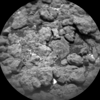
Curiosity Chemistry & Camera Remote Micro-Imager (RMI) photo acquired on Sol 3007, January 20, 2021.
Credit: NASA/JPL-Caltech/LANL
Quadrants
“The practice of dividing the terrain Curiosity explores into quadrants continued after Curiosity departed the landing ellipse,” Minitti reports, “to not only help focus mapping and path planning efforts, but to serve as a source of the names we assign to targets imaged, shot, drilled, or scooped.”
The rover has entered the “Torridon” (Scotland) quadrant on Sol 1896, and save a northward jaunt back into the “Biwabik” (Minnesota, USA) quadrant for 70 or sols, that Mars scientists have remained in the Torridon quadrant.
“Over this time,” Minitti notes, “all the targets we have named have required pages and pages of place names from Scotland (and Scotland adjacent) provided mostly by our team member Dr. John Bridges (University of Leicester). Those lists have produced great target names like “Muckle Flugga,” “Oban,” and “Bogmill Pow.””
However, in a recent rover drive, a three sol plan calls for exiting the Torridon quadrant and enter the “Nontron” (France) quadrant where the robot’s Chemistry and Comera (ChemCam) teammates are poised to help target pronunciations.
Nontronite
The Nontron quadrant name is particularly appropriate for the clay-bearing terrain Curiosity finds itself in, as Nontron is the type locality for a clay mineral called nontronite.
“Nontronite is part of the smectite group of clays, which are the most common types of clays on Mars,” Minitti explains. “The science team decided to send the Torridon quadrant out with a bang – literally – using the name ‘Saxa Vord Spaceport’ for a ChemCam target. Using the name of an in-the-works satellite launch site in northern Scotland also represents the speed at which we are rocketing toward the sulfate unit, having completed a nearly 100 meters drive in the last plan, and looking forward to a roughly 246 feet (75 meters) drive in this plan.”
Coolest name
While undoubtedly the coolest name in the plan, Saxa Vord Spaceport was far from the only target name used in our busy plan, Minitti points out.
The robot’s ChemCam will also shoot bedrock targets “Easthouses” and “Jarishof,” and one of the fields of pebbles (“Whaligoe”) that we commonly see distributed in discreet patches (like in the image above).
The robot’s Alpha Particle X-Ray Spectrometer (APXS) and its Mars Hand Lens Imager (MAHLI) and Mastcam will get a closer look at Easthouses after ChemCam shoots it.

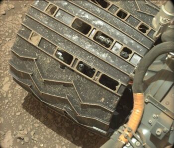
Curiosity Mars Hand Lens Imager photo produced on Sol 3005, January 18, 2021.
Credit: NASA/JPL-Caltech/MSSS
Near and far
Mastcam is also to take images of the terrain around the rover near and far.
“Mosaics of “Sandsayre” and “Rackwick” to rover left and right will record bedrock textures and structures, a mosaic of the more distant “Cromalt Hills” will capture their vertical structure, and yet another mosaic will image the contact between the fractured intermediate unit we are currently driving through and the rubbly version of this unit that we recently explored,” Minitti adds.
On each sol of the plan, Dynamic Albedo of Neutrons (DAN) will seek the signal of hydrogen in the ground below the robot using both their active and passive modes, the Rover Environmental Monitoring Station (REMS) will record the weather conditions, and the Radiation Assessment Detector (RAD) will monitor the radiation environment.
“These systematic measurements are complemented by images from Navcam and Mastcam that will hopefully capture clouds and dust devils and will measure the amount of dust in the skies above all the quadrants in Gale,” Minitti concludes.


