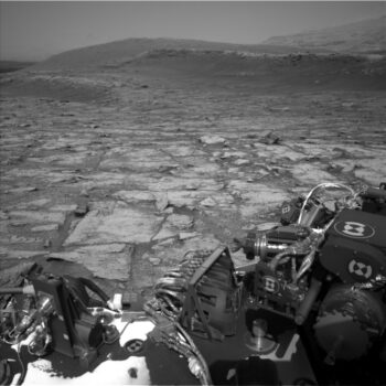
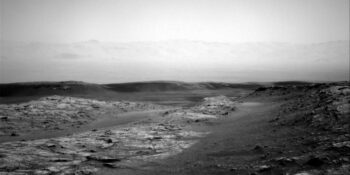
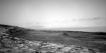
Image taken by Curiosity’s Left Navigation Camera on Sol 2933, November 5, 2020 showing the next set of benches in the distance, perhaps meter-scale stair steps carved into the landscape.
Credit: NASA/JPL-Caltech
NASA’s Curiosity Mars rover is now performing Sol 2938 tasks.
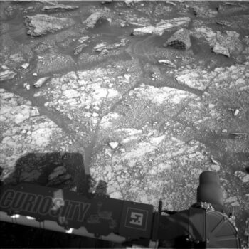
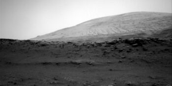
Curiosity Left B Navigation Camera photo taken on Sol 2937, November 9, 2020.
Credit: NASA/JPL-Caltech
Abigail Fraeman, a planetary geologist at NASA’s Jet Propulsion Laboratory, reports that the rover’s latest drive has placed it on top of one of the “rock benches” that are present throughout the area. A visual bonus: the views are just gorgeous.
“There are dinner plate-sized patches of layered bedrock in the rover’s workspace, which are quite a contrast to the pebble filled workspace we saw at our last location,” Fraeman adds. “We can also see the next set of benches in the distance, and I think they look like meter-scale stair steps carved into the landscape.”
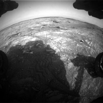
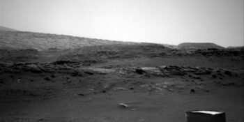
Curiosity Front Hazard Avoidance Camera Right B image acquired on Sol 2937, November 9, 2020.
Credit: NASA/JPL-Caltech
Sedimentary structures
A recent plan had the robot take advantage of the spectacular view and acquire a 108 frame Mastcam stereo mosaic.
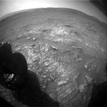
Curiosity Rear Hazard Avoidance Camera Right B image taken on Sol 2937, November 9, 2020.
Credit: NASA/JPL-Caltech
“This mosaic will help us further distinguish the sedimentary structures preserved in the rocks in this unique topographic region and it will enable us to find the best areas for closer investigations in later sols,” Fraeman explains.
Scientists will also take some time to learn more about the bedrock of the “benchtop” by collecting Mars Hand Lens Imager (MAHLI) and Alpha Particle X-Ray Spectrometer (APXS) observations of targets named “Muckle Minn” and “Hunt Hill,” and Chemistry and Camera (ChemCam) observations of “Smugglers Cave,” “Achnashellach,” and “Achosnich.”
Curiosity Right B Navigation Camera photo taken on Sol 2937, November 9, 2020.
Credit: NASA/JPL-Caltech
“We will supplement the mega-Mastcam mosaic with two smaller mosaics of areas near the rover named “Voe” and “Roe,”” Fraeman notes.
Credit: NASA/JPL-Caltech/Univ. of Arizona
Driving to the northeast
After completing science activities, the rover is on tap for driving along the “benchtop” to the northeast for roughly 148 feet (45 meters) and take a large set of post-drive images that will be used to help with this week’s planning.
“In parallel to all of these geological studies, we will continue to monitor the environment around the rover with a series of Navcam and Mastcam observations and standard set of pressure and temperature measurements,” Fraeman concludes.
Curiosity Right B Navigation Camera photo taken on Sol 2937, November 9, 2020.
Credit: NASA/JPL-Caltech
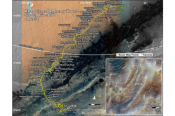
Road map
A new rover road map has been posted showing the route driven by Curiosity through the 2936 Martian day, or sol, of the rover’s mission on Mars (November 8, 2020).
Curiosity Right B Navigation Camera photo taken on Sol 2937, November 9, 2020.
Credit: NASA/JPL-Caltech
Numbering of the dots along the line indicate the sol number of each drive. North is up. The scale bar is 1 kilometer (~0.62 mile).
From Sol 2933 to Sol 2936, Curiosity had driven a straight line distance of about 123.14 feet (37.53 meters), bringing the rover’s total odometry for the mission to 14.47 miles (23.29 kilometers).
Curiosity Right B Navigation Camera photo taken on Sol 2937, November 9, 2020.
Credit: NASA/JPL-Caltech
The base image from the map is from the High Resolution Imaging Science Experiment Camera (HiRISE) onboard NASA’s Mars Reconnaissance Orbiter.

