Archive for the ‘Space News’ Category

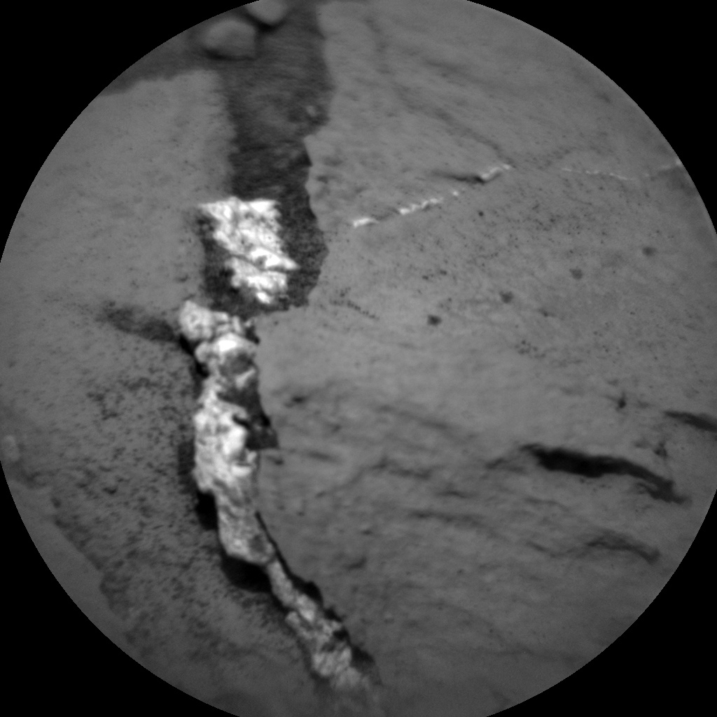
Opportunity’s Panoramic Camera imaged this area on Sol 4059.
Credit: NASA/JPL-Caltech/Cornell Univ./Arizona State Univ.
Word from ground controllers is that the Opportunity Mars rover is in good health after communication blackout.
The Earth-Mars Solar Conjunction command moratorium and communication blackout has ended. Telemetry is again being received from Opportunity. Normal tactical planning has resumed with the Sol 4059 (June 25, 2015) plan.
Opportunity is on the west rim of Endeavour Crater at the “Spirit of St. Louis” crater near the entrance of “Marathon Valley.”

Veteran Opportunity Mars rover snapped this photo following Earth-Mars Solar Conjunction on Sol 4059.
Credit: NASA/JPL-Caltech/Cornell Univ./Arizona State Univ.
The robot landed on Mars on Jan. 25, 2004, Universal Time (evening of Jan. 24, 2004, PST).
Since landing, the veteran rover has chalked up over 26 miles (42 kilometers) of exploration driving.

Credit: ALE
ALE CO. Ltd. is a Japan-based space technology company that wants to provide artificial shooting stars “any time, any place as you like.”
According to Lena Okajima, head of ALE in Tokyo, her group is working with experts in various Japanese universities to develop a spacecraft that can toss out tiny balls from Earth orbit to create on-demand shooting stars.

Shooting star chief, Lena Okajima, head of ALE in Tokyo.
Credit: ALE
“A particle will be released from the platform of our artificial satellite that is circulating the globe in a circular orbit utilizing a mass driver to penetrate the atmosphere,” notes the ALE website.
Want to make a wish upon a shooting star? You can be a paying customer for this on-demand planetary pyrotechnic sky service.
The released ball would plow through the Earth’s atmosphere at high-speed, blazing to brilliance and observable from the ground.

Shooting star hardware.
Credit: ALE
In fact, depending on your pre-disposed idea of how colorful you want your shooting stars, you can have ingredients introduced that alter the tint of the incoming object or objects.

Shooting star balls.
Credit: ALE
For more information on this kinetic killer of an app, go to:
https://www.linkedin.com/pub/lena-okajima/1a/915/243

Curiosity: Back on-line after solar conjunction.
Credit: NASA/JPL/USGS
“Mars has passed through solar conjunction, and reliable communication with the spacecraft at Mars is possible again,” explains Ken Herkenhoff, a member of the Curiosity Mars rover team.
As the team starts implementing the Sol 1027 plan, the NASA Curiosity rover’s Mastcam observations of several targets that were imaged just before solar conjunction are being reviewed – a look is underway to spot changes caused by winds or maybe Marsquakes, Herkenhoff notes.
Ground controllers were waiting for more data to be relayed by Mars orbiters to confirm that Curiosity is ready to resume science planning. But ground controllers have proceeded with tactical planning so that they would be ready when the data arrived.

This image was taken by Mastcam: Right (MAST_RIGHT) onboard NASA’s Mars rover Curiosity on Sol 1027 (2015-06-27 09:13:00 UTC).
Credit: NASA/JPL-Caltech/MSSS
Nearby targets
Herkenhoff of the U.S. Geological Survey’s Astrogeology Science Center in Flagstaff, Arizona, said the rover’s Mastcam is slated to look at the Sun to measure the amount of dust in the atmosphere.
Also, Curiosity’s Navcam will search for dust devils, and ChemCam/Mastcam will observe nearby targets “Piegan” and “Wallace.”
This image was taken by ChemCam: Remote Micro-Imager (CHEMCAM_RMI) onboard NASA’s Mars rover Curiosity on Sol 1027 (2015-06-27 08:30:21 UTC).
Credit: NASA/JPL-Caltech/LANL
On Sol 1028, the camera-carrying Curiosity robot arm will be used to take up-close images of the rocks and soil in front of the rover from various vantage points, to measure changes in their reflectance.
After dusk, rover instruments will measure three spots on a rock called “Big Arm” that was imaged during the day before solar conjunction.
Lastly, nighttime images, using LEDs for illumination, should “nicely complement” the daytime images of the rock, Herkenhoff said.
Back in action
Finishing off the weekend plan, on Sol 1029 the rover’s ChemCam instrument will acquire some calibration data and Mastcam will take a stereo mosaic of the outcrops to the east of the rover.
Overall, the word from the Curiosity downlink team is that the data acquired during conjunction show that the rover is in good health, and that the rover team is “go” for planning.
Bottom line from Herkenhoff: Curiosity “is back in action!”

Secretary of State John Kerry shakes hands with Chinese Vice Premier Wang Yang after they delivered closing statements at the conclusion of the U.S.-China Strategic and Economic Dialogue (S&ED) / Consultation on People-to-People Exchange (CPE) at the U.S. Department of State in Washington, DC.
Credit: State Dept Image /June 24, 2015
The seventh round of the U.S.-China Strategic and Economic Dialogue (S&ED) was held June 22-24, 2015, in Washington, D.C.
The two sides held in-depth discussions on major bilateral, regional, and global issues, including a number of space agenda items.
“The depth and breadth of our discussion at this year’s Strategic & Economic Dialogue has been significant,” said Secretary of State John Kerry, “and I think it is fair to say from my perspective, certainly – this is my third dialogue – that this has been perhaps one of the more constructive and productive in terms of the seriousness of the discussion that we’ve had on a very long, comprehensive agenda, with a host of important bilateral, regional, and global issues.
Space-related items
Under the banner of “Cooperation on Science, Technology, and Agriculture” several space-related items have been flagged, including space security, satellite collision avoidance, weather monitoring, climate research, and establishing regular civil space cooperation consultations.
Specifically, these are:
Space: The United States and China decided to establish regular bilateral government-to-government consultations on civil space cooperation. The first U.S.-China Civil Space Cooperation Dialogue is to take place in China before the end of October Separate from the Civil Space Cooperation Dialogue, the two sides also decided to have exchanges on space security matters under the framework of the U.S.-China Security Dialogue before the next meeting of the Security Dialogue.

Earth orbit is a junkyard of human-made space clutter.
Credit: Space Junk 3D, LLC. Melrae Pictures
Satellite Collision Avoidance: The United States and China reaffirmed that orbital collision avoidance serves the common interest of the two sides in the exploration and use of outer space for peaceful purposes. The two sides noted that the process for safely resolving an orbital close approach requires further consultation, with a view to building upon existing cooperation between the two sides in order to ensure timely resolution to reduce the probability of accidental collisions. The two sides further decided to continue bilateral government-to-government consultations on satellite collision avoidance and the long-term sustainability of outer space activities as part of the U.S.-China Civil Space Cooperation Dialogue.
Joint Research on Severe Weather Monitoring: The United States and China decided to enhance data and information exchange and cooperation on joint research and development of monitoring, warning, and risk assessment technologies for severe weather and climate, such as hurricanes (typhoons), strong convective weather events, droughts, high temperatures, and heat waves. These efforts are intended to jointly improve the two sides’ ability to respond to severe weather and climate events.
![Credit: Courtesy of SOHO/[instrument] consortium. SOHO is a project of international cooperation between ESA and NASA.](https://www.leonarddavid.com/wp-content/uploads/2015/06/suncombo1_prev.jpg)
Credit: Courtesy of SOHO/[instrument] consortium. SOHO is a project of international cooperation between ESA and NASA.

Credit: NASA
Climate Science and Climate Services: The United States and China enhanced cooperation and research in the areas of climate science and climate services, including extended-range forecasts, drought monitoring outlooks, El Nino-Southern Oscillation monitoring, outlooks of tropical atmosphere Madden-Julian Oscillation and monsoon monitoring. The two sides decided to enhance bilateral cooperation in climate services under the Global Framework for Climate Services.
Operational Forecast and Service of Space Weather: The United States and China enhanced cooperation and exchange in space weather monitoring programs, forecasts and services.
Tangible benefits
In remarks signaling the end of the U.S.-China Strategic and Economic Dialogue, Chinese Vice Premier Wang Yang noted: “With two days of intensive and orderly work, the seventh round of China-U.S. economic dialogue has achieved a full success. The two sides conducted candid and in-depth exchange of views on issues of overarching, long-term and strategic importance to the two economies and the world economy and reached over 70 important outcomes.”
Chinese State Councilor Yang Jiechi observed: “The two sides agreed to enhance exchanges and cooperation on counterterrorism, nonproliferation, law enforcement, and anti-corruption; space, science, and technology; customs, health, agriculture, forestry, transport, and local exchanges with a view to bring more tangible benefits to the people of our two countries.”

On November 14, 2014, Wang Zhaoyao, Director of the China Manned Space Agency, held a conversation with the delegation of NASA chief Charles Bolden.
Credit: CMSE
TBD: Where’s NASA?
Regarding the China and U.S. space agenda items, Marcia Smith, space policy analyst at SpacePolicyOnline.com commented:
“NASA and the White House Office of Science and Technology Policy (OSTP) have been prohibited by law from dealing with China on space cooperation on a bilateral basis for several years,” Smith noted.
The prohibition was originally inserted in the appropriations bills that fund NASA by Rep. Frank Wolf (R-VA), who chaired the House Appropriations Commerce-Justice-Science (CJS) subcommittee before retiring last year, Smith explained.
The final law that he put in place (P.L. 113-235, the Consolidated and Further Continuing Appropriations Act, 2015), which is in effect today, Smith added, states that no funds may be spent by NASA or OSTP to “develop, design, plan, promulgate, implement, or execute a bilateral policy, program, order, or contract of any kind to participate, collaborate, or coordinate bilaterally in any way with China or any Chinese-owned company unless such activities are specifically authorized by law after the date of enactment of this Act.”
The new House CJS chairman, Rep. John Culberson (R-TX), agrees with Wolf’s position and the prohibition is continued in the House-passed version of the FY2016 Commerce-Justice-Science appropriations bill (H.R. 2578), Smith said.

NASA chief, Charles Bolden, with Wang Zhaoyao, Director of the China Manned Space Agency, during meeting last November.
Credit: CMSE
Future meetings
“The agreement signed by Kerry reflects State Department activities with China, which are not prohibited by law,” Smith posted on her website.
“The State Department has a Bureau of Oceans and International and Scientific Affairs — often referred to as Oceans, Environment and Science (OES) — that oversees international civil space cooperation and presumably will be the official host of these [future U.S. – China space] meetings. If and how NASA will be involved apparently is yet to be determined,” Smith concluded.

Credit: NASA/LPI
NASA is moving forward on planting bootprints on the Red Planet.
The “First Landing Site/Exploration Zone Workshop for Human Missions to the Surface of Mars” will be held this October at the Lunar and Planetary Institute (LPI) in Houston, Texas.
The purpose of this workshop to be held October 27-30 is to identify and discuss candidate locations where humans could land, live, and work on the Martian surface.

Credit: NASA/LPI
Zoning in on Mars
This gathering will focus on “exploration zone” layout considerations. That is, identifying Regions of Interest (ROIs) that are located within approximately 60 miles (100 kilometers) of a centralized landing site.
ROIs are further defined as areas that are relevant for scientific investigation and honing the capabilities and resources necessary for a sustainable human presence
An exploration zone, or EZ, on Mars also contains a landing site and a habitation site that will be used by multiple human crews during missions to explore and utilize the ROIs within a selected zone.

Credit: Dan Durda
Multi-year process
Stemming from the meeting, candidate EZs will be used by NASA’s Human Exploration and Operations Mission Directorate (HEOMD) and Science Mission Directorate (SMD) as part of the multi-year process of determining where and how NASA would like to explore Mars with humans.
In the near term this process includes:
— Identifying locations that would maximize the potential science return from future human exploration missions
— Identifying locations with the potential for resources required to support humans
— Developing concepts and engineering systems needed by future human crews to conduct operations within an EZ
— Identifying key characteristics of the proposed candidate EZs that cannot be evaluated using existing data sets, thus helping to define precursor measurements needed in advance of human missions.

Credit: NASA
Future work
Existing and future robotic spacecraft will be tasked to gather data from specific Mars surface sites within the representative EZs to support these HEOMD and SMD activities.
This first meeting is likely to kick-start teams of scientists and engineers to flesh out exploration zones that emerge from the initial workshop.

Left to right: Moderator – Gil Rudawsky, Vice President, GroundFloor Media; Leonard David, Reporter – Inside Outer Space; Laura Keeney, Business Reporter – The Denver Post; Greg Avery, Reporter – Denver Business Journal; and Maya Rodriguez, TV Reporter – KUSA.
Photo credit: Barbara David
Colorado’s aerospace industry is growing and outperforming national economic trends.
Eight of the country’s major space contractors have a significant presence in Colorado and the state continually outperforms national averages in employment, salary, and education.
In 2014, Colorado ranked first in private aerospace employment in the U.S. and direct and indirect aerospace employment exceeded 160,000 workers in high wage jobs, with a payroll of close to $3.2 billion.
Digital landscape
Given those factoids, the Colorado Space Business Roundtable held on Thursday, June 25 a media-centric Aerospace Exchange and Media panel discussion. The event took place at The Denver Press Club.
This reporter was honored to take part in the conversation.
Panel members focused on how best aerospace firms can build relationships with journalists across Colorado, the challenges facing media in the evolving digital landscape, and understanding what journalists find most interesting to cover.
Special thanks to Edgar Johansson, President of the Colorado Space Business Roundtable; Citizens for Space Exploration; Aerospace Exchange Sponsor, Braxton Science & Technology Group; and Event Chair, Krystal Scordo, Marketing Services Manager for Sierra Nevada Corporation’s Space Systems.
For more information on the Colorado Space Business Roundtable, go to:

Credit: Orbital Systems
A design concept for future Mars missions has led to a system commercially suitable for Earthly water applications for non-potable use.
The “Shower of the Future” offered by Orbital Systems, a Swedish clean tech start-up, shares the same water purification technology that NASA uses in space.
This technology was spurred by a cooperative effort of the Habitation and Exploration Missions and Systems Office at NASA’s Johnson Space Center (JSC), together with the School of Industrial Design at Lund University in Sweden.
Space certified
The Space Foundation’s international Space Certification program announced today that it has “space certified” the new technology.
“Products and services that display the Space Certification seal are guaranteed to have stemmed from, or been dramatically improved by, technologies originally developed for space exploration or to have significant impact in teaching people about the value of space utilization,” according to The Space Foundation, based in Colorado Springs, Colorado.
This technology — setting a higher standard for domestic water consumption — began as an academic joint project between Mehrdad Mahdjoubi, Orbital Systems’ CEO and Founder, and NASA JSC in Houston.
The team is supported by an advisory board that includes Larry Toups, a NASA systems engineer, as well as designer and professor Claus-Christian Eckhardt and Skype founder Niklas Zennström, who is also an investor in the company.

Credit: Orbital Systems
Precious resources
“It’s Rocket Science,” explains the company’s website. “Inspired by an academic collaboration project with NASA, our technology applies the same principles you live by in space; that Earthly resources are precious and must be used in the most efficient way possible.”
According to Orbital Systems: “We are facing a very interesting future as our technology is breaking grounds and changing the way we humans relate to domestic water consumption. We aim to replace the inefficient and costly structures of today, with a cleaner, cheaper and more sustainable solution. Domestic water consumption, whether it’s drinkable water to secure living conditions or heated water for hygienic purposes, is a key factor for our future well-being.”
FAQ
The company has assembled a “Frequently Asked Questions” list, starting off with: “What happens if I urinate in the Shower of the Future?”
To find out the answer and learn more about the “Shower of the Future,” go to:
and

Orbital Systems logo
Credit: Orbital Systems

Big bang theory: ESA’s Asteroid Impact Mission (AIM), a candidate mission due for launch in 2020.
Credit: ESA–ScienceOffice.org
They are mean and malicious – and could mess up your day here on Earth.
That said about asteroids, an upcoming “global day of awareness and education” is incoming on June 30 – the anniversary of the 1908 Tunguska impact in Siberia, the largest asteroid hit on Earth in recently recorded history.
The Tunguska incident shattered roughly 800 square miles of forest, the approximate size of a major metropolitan city today.
Tunguska is the only natural disaster that we know how to prevent through early detection, yet less than one percent of asteroids of this size have been detected.
Ready, AIM, fire!
Over the years, many ideas have been “floated” on how best to deal with a menacing asteroid that has Earth’s name on it.
For example, engineers recently began the preliminary design of the European Space Agency’s (ESA) Asteroid Impact Mission (AIM) concept.

The European Space Agency’s (ESA) Asteroid Impact Mission concept, currently under study, would be humanity’s first mission to a binary asteroid: the 2,624 feet (800 meter) diameter Didymos is accompanied by a 558 feet (170 meter) diameter secondary body.
Credit: ESA–ScienceOffice.org
That mission could involve some four different spacecraft. AIM is tasked to encounter and chart the Didymos double asteroid — the binary asteroid system of Didymos and its moon — and then witness it being struck by another spacecraft, returning data to help guide planetary defense strategies.
AIM workers are now busy at work sketching out details. The chosen concept will be presented to ESA’s Council of Ministers in November 2016 for possible approval.
Double trouble
If approved, the mission concept would then become an actual ESA mission. From there, it’s translating artwork and computer-aided design drawings into reality.
AIM must be in position before late 2022 when NASA’s Double Asteroid Redirection Test, or DART, is planned to crash into the asteroid’s moon for detailed before-and-after impact monitoring.
These observations will help determine how far the DART kinetic impactor has moved the rocky world.
The two missions together are components of an international collaboration on an asteroid-deflection demonstration mission called the Asteroid Impact & Deflection Assessment (AIDA).

Wake-up call: The 2013 incoming space rock over Chelyabinsk, Russia.
Credit: Alex Alishevskikh
Global cooperation
“We are delighted that ESA has completed their AIM Pre-Phase-A study, and decided to officially move on to Phase-A concept definition,” says Lindley Johnson, NASA’s Near-Earth Object Program Executive.
“Our own DART mission is scheduled to initiate its Phase-A study in a few months,” Johnson adds.
The bottom line is that such a combined mission of AIM and DART would make the joint AIDA mission “the world’s first attempt to demonstrate that international space agencies working together could protect the Earth from an asteroid impact,” ESA points out.

Tunguska: The largest recent impact event.
Credit: Leonid Kulik Expedition
Tune-in time
While policy, technology and international cooperation work their respective ways, tune into Asteroid Day at the California Academy of Sciences.
To be held on June 30, the event includes asteroid experts and astronauts speaking at the event, as well as individuals signing the 100X Declaration showing their support for increased public education and early detection of asteroids.
It will be Webcast at: www.asteroidday.org
The hosts are the B612 Foundation and California Academy of Sciences.
Also highlighted on Asteroid Day are additional videos from more than 50 worldwide events.
Follow Asteroid Day on Twitter: #AsteroidDay @AsteroidDay and Facebook:

Credit: U.S. Air Force
Just in time for the December release of the next installment of Star Wars.
A new center is being eyed by the U.S. Pentagon and the intelligence community to hone tactics in the event of war in orbit.
That’s the news from reporters at Defense One, based on coverage of Deputy Defense Secretary Robert Work’s keynote address at a GEOINT symposium, an annual intelligence conference sponsored by the United States Geospatial Intelligence Foundation.

Credit: Walt Disney Company
The ops center is to be up and running within six months, making use of data from satellites belonging to all government agencies, Defense One reports.
The new center would back up the military’s Joint Space Operations Center at Vandenberg Air Force Base, California.
The center would assist the military and the government to coordinate preparations for and responses to any attack, Defense One explains. This new facility is tied to a $5 billion boost for space security in the Department of Defense 2016 budget request.
Resources
To read the Defense One story, “Pentagon Rushing to Open Space-War Center to Counter China, Russia,” go to:
http://www.defenseone.com/management/2015/06/pentagon-preparing-war-space-russia-china/116101/
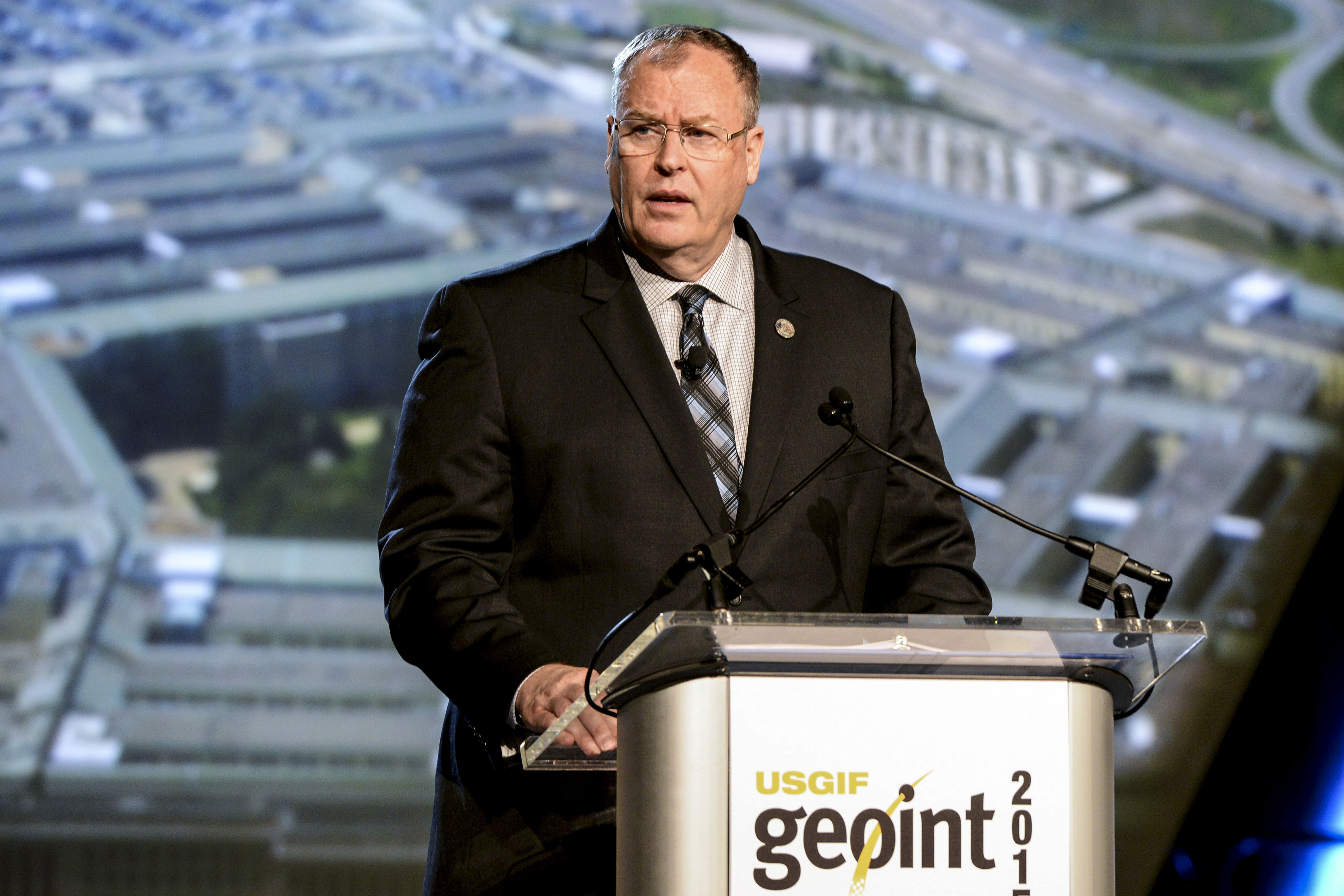
Deputy Secretary of Defense Bob Work delivers remarks at the U.S. Geospatial Intelligence Foundation (GEOINT 2015) Symposium, Walter E. Washington Convention Center on June 23 , 2015.
Credit: DoD/U.S. Army Sgt First Class Clydell Kinchen
To view a video of Deputy Defense Secretary Robert Work’s keynote talk this week at the GEOINT symposium, go to:
https://vimeo.com/131619967#at=0

Long distance interstellar sailing.
Credit: UCSB/Adrian Mann
It is tagged as Directed Energy Propulsion for Interstellar exploratioN (DEEP-IN), work that will also chart laser driver elements that require technology development.
Thanks to a grant from the NASA Innovative Advanced Concepts (NIAC) program, research is underway to consider using directed energy propulsion for interstellar travel.
Directed energy propulsion
The work is underway by the University of California Santa Barbara’s (UCSB) Experimental Cosmology Group. They are focused on use of lasers as a means to power a spacecraft. A laser-powered, wafer-thin spacecraft, the UCSB group suggests, could be capable of reaching Alpha Centauri in 20 years.
Explains UCSB physics professor Philip Lubin: “We propose a system that will allow us to take the first step toward interstellar exploration using directed energy propulsion combined with miniature probes.”

UCSB physics professor Philip Lubin is leading a “stellar team” that’s locked in on laser propulsion to travel interstellar distances.
Credit: UCSB
Lubin adds that, along with recent work on wafer-scale photonics, “we can now envision combining these technologies to enable a realistic approach to sending probes far outside our solar system.”
Ultimate goal
The UCSB group’s “ultimate goal” is to send small probes to supplement the current long-range remote sensing done by orbital and ground-based telescopes.
The NIAC funding is enabling Lubin’s team to create a more complete roadmap for building a fully functional wafer-scale spacecraft complete with power, laser communications and controllable photon thrusters.
UCSB’s DEEP-IN design keeps the main propulsion driver back in Earth’s orbit (or nearby) – yet still capable of propelling highly integrated spacecraft to speeds vastly higher than anything scientists can currently achieve.
No intrinsic speed limit
According to a UCSB press advisory, the laser photon driver would use photon pressure in the form of streamed energy to power the spacecraft as it travels away from Earth.
With no intrinsic speed limit, this technology allows for the relativistic speeds necessary for interstellar flight, according to the study team.
“We’ve had to radically rethink our strategy in order not to give up our dreams of reaching the stars,” Lubin added. “DEEP-IN posits a technological path forward that, while not simple, is within our technological reach to begin.”

