Archive for the ‘Space News’ Category

Dated January 19, 2016, this self-portrait of NASA’s car-size Curiosity Mars rover shows the vehicle at “Namib Dune.” This is a locale where the rover’s activities included scuffing into the dune with a wheel and scooping samples of sand for laboratory analysis. This new selfie combines 57 images taken by the Mars Hand Lens Imager (MAHLI) camera at the end of Curiosity’s arm.
Credit: NASA/JPL-Caltech/MSSS
NASA’s Curiosity Mars rover is entering Sol 1239, with ground controllers still trying to troubleshoot a problem with the arm-mounted Collection and Handling for In-situ Martian Rock Analysis device – CHIMRA for short.
Soil samples are acquired with CHIMRA’s clam-shell scoop mechanism.

Diagram of CHIMRA, showing the scoop in an open position (indicated here in red).
Credit: NASA/JPL
The CHIMRA is a device that sieves and portions the samples from the scoop and the drill which are then distributed to the analytical instruments, the Sample Analysis at Mars (SAM) Instrument Suite and the Chemistry & Mineralogy X-Ray Diffraction/X-Ray Fluorescence Instrument (CheMin). Various chambers and labyrinths within the mechanism are used to sort and sieve the drilled rock or scooped soil material.
Backlog of data
On Friday, Ryan Anderson, a planetary scientist at the USGS Astrogeology Science Center in Flagstaff, Arizona and a member of the Chemistry & Camera (ChemCam) team on the Mars Science Laboratory (MSL), reported:
“Since the anomaly with CHIMRA is still being investigated, there was no science involving the arm in today’s plan. Still, there was plenty to do, and we had to be careful not to collect too much extra data because there is a backlog of data on the rover waiting to be downlinked to Earth.”

The Mars Hand Lens Imager (MAHLI) camera on the robotic arm of NASA’s Curiosity Mars rover used electric lights at night on Jan. 22, 2016, to illuminate this postage-stamp-size view of Martian sand grains dumped on the ground after sorting with a sieve.
Credit: NASA/JPL-Caltech/MSSSOn Friday, Ryan Anderson, a planetary scientist at the USGS Astrogeology Science Center in Flagstaff, Arizona and a member of the Chemistry & Camera (ChemCam) team on the Mars Science Laboratory (MSL), reported:“Since the anomaly with CHIMRA is still being investigated, there was no science involving the arm in today’s plan. Still, there was plenty to do, and we had to be careful not to collect too much extra data because there is a backlog of data on the rover waiting to be downlinked to Earth.”
Fine-scaled layering
Looking ahead to Sol 1239, the plan calls for observations of a target called “Gosser Schroffenstein” in the area called “Mniszechis Vlei.”
That site is where the rover’s “wheel scuff” in the sand exposed a tiny scarp or cliff in the sand, Anderson explains. “This little scarp gives us a good view of the fine-scaled layering in the top few centimeters of the dune,” he adds.
Anderson points out that once the science is done on Sol 1239 there is additional diagnostics on the balky CHIMRA. Later in the day on Sol 1239, Curiosity’s Chemistry & Mineralogy X-Ray Diffraction/X-Ray Fluorescence Instrument (CheMin) is on tap to analyze some of the sand that was collected previously.
Also slated are long-distance Remote Microscopic Imager (RMI) mosaics of Mt. Sharp.

Curiosity’s Mastcam Right image taken on January 29, 2016 on Sol 1237.
Credit: NASA/JPL-Caltech/MSSS
Wind moves
Rover science teams are looking at possible sites for the next use of Curiosity’s drill to collect rock-powder samples of the bedrock in the area.
Landing on Mars in August 2012, Curiosity reached the base of Mount Sharp in 2014 after investigating outcrops closer to its landing site and then trekking to the layered mountain.
On the lower portion of the mountain, the robot is studying how Mars’ ancient environment changed from wet conditions favorable for microbial life to harsher, drier conditions.
Curiosity has been surveying a group of active sand dunes for two months. The rover is studying how the wind moves and sorts sand particles on Mars. The site under study by the robot is part of Bagnold Dune Field, which lines the northwestern flank of Mars’ Mount Sharp.

The Panoramic Survey Telescope & Rapid Response System (Pan-STARRS) 1 telescope on Maui’s Mount Haleakala, Hawaii has produced the most near-Earth object discoveries of the NASA-funded NEO surveys in 2015.
Credit: University of Hawaii Institute for Astronomy/Rob Ratkowski
The outlook of Earth being on the receiving end of a menacing asteroid in the future is real – but very much in the celestial cards of chance.
But when the high-stakes card is dealt, responding to a hostile near-Earth object (NEO) is a global challenge.
In early January, NASA announced the establishment of a Planetary Defense Coordination Office (PDCO) created to coordinate U.S. agencies and intergovernmental efforts to respond to future near-Earth objects that threaten Earth.

Proposed NEOCam space telescope can survey the regions of space closest to the Earth’s orbit, where potentially hazardous asteroids are most likely to be found. NEOCam will use infrared light to characterize their physical properties such as their diameters.
Credit: NASA/JPL-Caltech
Synchronizing NEO efforts
Among its functions, the PDCO has been set up to not only synchronize NEO efforts in the U.S. but also supervise all NASA-funded projects to find and characterize asteroids and comets that pass near Earth’s orbit around the sun.

First telescope of the Asteroid Terrestrial-Impact Last Alert System (ATLAS) system is up and operating on Haleakala.
Credit: Institute for Astronomy at the University of Hawaii
In an exclusive interview, I talked with the chief of that office, NASA’s Lindley Johnson.
Go to my new Space.com story on how Johnson sees the office shaping up and goals for 2016 at:
NASA’s New Planetary Defense Office Gets to Work Protecting Earth
By Leonard David, Space.com’s Space Insider Columnist
January 29, 2016 07:52am ET
http://www.space.com/31770-nasa-planetary-defense-office-asteroid-threat.html

Curiosity Mars Hand Lens Imager (MAHLI) photo taken on January 19, 2016, during Sol 1228 operations.
Credit: NASA/JPL-Caltech/MSSS
The Curiosity rover on Mars has run into an anomaly using its Collection and Handling for In-Situ Martian Rock Analysis (CHIMRA) device. That hardware is attached to the turret at the end of the robotic arm on the Red Planet machinery.
“The cause of the CHIMRA anomaly is still being investigated,” reports Ken Herkenhoff of the USGS Astrogeology Science Center in Flagstaff, Arizona. The problem has curtailed robotic arm motion, while diagnostic testing on CHIMRA continues.
Bad behavior
The CHIMRA behaved in an unexpected way during processing of the third scoop of sand back on Sol 1231. Experts have been evaluating the anomalous behavior of the device and developing a recovery plan.

NASA’s Mars rover Curiosity image taken on Sol 1221, January 12, 2016.
Credit: NASA/JPL-Caltech
Only remote science observations from Curiosity are being allowed, Herkenhoff adds.
Curiosity is now in Sol 1237 operations.
MRO maintenance
There has been a reduction in volume of data from the rover, Herkenhoff notes, because the NASA Mars Reconnaissance Orbiter (MRO) is undertaking pre-planned maintenance this week and cannot relay data from Curiosity. “Fortunately, it looks like we will be able to get all the critical data via the Mars Odyssey orbiter,” he points out.
In addition to the CHIMRA diagnostic tests on Sol 1237, the rover’s Chemistry & Camera (ChemCam) and Mastcam were to image the alluvial fan northeast of the rover, at the base of the Gale crater wall.
Wheel scuff in stereo
The rover’s Mastcam and Navcam are also to take stereo images of the edge of the area disturbed by Curiosity’s wheel “scuff” named “Mniszechis Vlei.”
Herkenhoff explains that the command to allow the Sample Analysis at Mars (SAM) instrument suite to examine a sample of dune sand was not received, “so we’ll try again overnight between Sols 1237 and 1238.”
The plan calls for Sol 1238 to include day use of ChemCam to observe the sky and continue checking out new software that will allow autonomous ChemCam targeting.

CURIOSITY Mars Hand Lens Imager (MAHLI) image taken on January 19, 2016, Sol 1228.
Credit: NASA/JPL-Caltech/MSSS
Detection observations
“Mastcam change detection observations of the sand dune are also sprinkled throughout the plan,” says Herkenhoff.
Finally, just after sunset the Remote Micro Imager (RMI) telescope is slated to take images of the sky for instrument calibration. “We have been trying to plan this observation for weeks, and were glad to be able to include it in today’s plan,” Herkenhoff concludes.
NOTE: Dates of planned rover activities are all subject to change due to a variety of factors related to the Martian environment, communication relays and rover status.

Credit: Mary Ann Liebert, Inc. Publishers
The informative New Space journal is offering free access to an “uplifting” set of articles on the space elevator concept.
This free access to readers is available through February 29th.
Read now:
- Opening up Earth-Moon Enterprise with a Space Elevator
By Peter A. Swan
Go to:
http://online.liebertpub.com/doi/pdf/10.1089/space.2015.0025
- The Status of Space Elevator Infrastructures
By John M. Knapman and Peter A. Swan
Go to:
http://online.liebertpub.com/doi/pdf/10.1089/space.2015.0028
- A Historical Look at the Concept of Space Elevators
By David I. Raitt
Go to:
http://online.liebertpub.com/doi/pdf/10.1089/space.2015.0024
NOTE: Special thanks to New Space Editor-in-Chief Scott Hubbard and Mary Ann Liebert, Inc. publishers for making these new space elevator articles available.

Because the Centaurs cross the paths of the major planets, their orbits are unstable: some will eventually be ejected from the solar system, but others will be thrown onto trajectories bringing them inwards, therefore posing a danger to civilization and life on Earth.
Credit: Duncan Steel
All the hoopla over that “should be there” Planet 9 has spurred speculation about its danger to Planet 3 – Earth.
So far, just mathematical modeling and computer simulations suggest this way out world could have a mass about 10 times that of Earth. Furthermore, this purported planet would make one full orbit around the Sun, a period of time that takes between 10,000 and 20,000 years.
This still to be seen planet orbits about 20 times farther from the Sun on average than does Neptune (which orbits the Sun at an average distance of 2.8 billion miles).

This artistic rendering shows the distant view from Planet Nine back towards the sun. The planet is thought to be gaseous, similar to Uranus and Neptune. Hypothetical lightning lights up the night side.
Credit: Caltech/R. Hurt (IPAC)
Unnerving possibility
Is it reasonable to consider an unnerving possibility: whether the orbit of this still speculative globe might not arouse waves of objects to tumble inward into our solar system, placing our world in peril?
Inside Outer Space asked that question of Duncan Steel at the Center for Astrobiology, University of Buckingham, and Armagh Observatory in the UK.
Steel and his colleagues recently reported that the discovery of hundreds of giant comets in the outer planetary system over the last two decades means that these objects pose a much greater hazard to life than asteroids.
The giant comets — termed centaurs — move on unstable orbits crossing the paths of the massive outer planets Jupiter, Saturn, Uranus and Neptune. The planetary gravitational fields can occasionally deflect these objects in towards the Earth.

Planet 9 backers, Caltech professor Mike Brown and assistant professor Konstanin Batygin, have been working together to investigate distant objects in our solar system
Credit: Lance Hayashida/Caltech
Reassessment of extraterrestrial factors
More to the point, as Steel has written: “The discovery of many substantial objects in the outer solar system demands a reassessment of extraterrestrial factors putatively implicated in mass extinction events.”
Steel has calculated the terrestrial impact probability for all known asteroids and questions whether the old concept of single, random asteroid impacts causing mass extinctions is “deficient” given what is now known of the inventory of small bodies in the solar system.
Waves of objects
The “problem”, as such, Steel told Inside Outer Space, is stirring up trans-Neptunian objects (TNOs). “This Planet 9 would likely fit the bill. That is, we might expect waves of objects to come inwards whenever Planet 9 is near perihelion and thus enters a denser region of TNOs.”
Be clear that most of the objects out there will be far smaller than the TNOs detected to date, Steel adds, “big devils, they have to be, to be detectable.”
“If this Planet 9 exists, then it may show itself in other ways, such as a shower of comets entering the inner solar system whenever Planet 9 nears perihelion,” Steel says. “We might see the 20,000 year periodicity in cometary dust deposits on Earth, for example. A problem would be that we know that Earth’s climate cycle, due to terrestrial orbit variations, follows a similar periodicity.”

The six most distant known objects in the solar system with orbits exclusively beyond Neptune (magenta) all mysteriously line up in a single direction. Also, when viewed in three dimensions, they tilt nearly identically away from the plane of the solar system. New work by Caltech’s Batygin and Brown show that a planet with 10 times the mass of the Earth in a distant eccentric orbit anti-aligned with the other six objects (orange) is required to maintain this configuration.
Credit: Caltech/R. Hurt (IPAC)/Diagram created using WorldWide Telescope.
Jury still out
On the Planet 9 hypothesis, Steel points out: “The jury is out on this idea, and will be for some time. It’s a useful and interesting suggestion, not altogether unexpected. There are certain to be contrary ideas.”
But if the claims for a Planet 9 are correct, “then more TNOs with similar orbits to those identified should be discovered over the next decade, adding to the statistical weight of evidence,” Steel concludes.

Opportunity image from Navigation Camera on Sol 4266.
Credit: NASA/JPL
Still running after all those years!
NASA’s Opportunity rover landed on Mars 12 years ago this week. The veteran robot touched down on the Red Planet on Jan. 24, 2004, PST (early Jan. 25, UTC).
Opportunity is alive and well, working through the lowest-solar-energy days of the mission’s seventh Martian winter. It has been using a diamond-toothed rock grinder and other tools in recent weeks to investigate clues about the planet’s environmental history.
Opportunity is now exploring the western rim of a 14-mile-wide (22-kilometer-wide) crater named Endeavour, doing so since 2011. This winter, the rover is inspecting rocks on the southern side of “Marathon Valley – a feature that slices through Endeavor Crater’s rim from west to east.

A dozen years on Mars. Opportunity Mars rover snagged this image using its Navigation Camera on Sol 4266.
Credit: NASA/JPL
This is a location where observations by NASA’s Mars Reconnaissance Orbiter have mapped concentrations of clay minerals that would have formed under wet, non-acidic conditions.
“With healthy power levels, we are looking forward to completing the work in Marathon Valley this year and continuing onward with Opportunity,” said Mars Exploration Rover Project Manager, John Callas of NASA’s Jet Propulsion Laboratory, Pasadena, California.

History-making Viking Mars landers touched down on the Red Planet in 1976 – four decades ago this year.
Credit: NASA
The seminal Viking orbiter and lander Mars missions of the 1970s were a landmark enterprise, giving the U.S. a big plus in the Red Planet exploration column. That epic NASA saga of exploration took place 40 years ago this year.
Now, for the first time, over 300 artifacts from the Viking Mars Missions Education & Preservation Project (VMMEPP) are available to people around the world.
The artifact availability comes via a partnership between VMMEPP and the Google Cultural Institute. The Google Cultural Institute and its partners are putting the world’s cultural treasures at the fingertips of Internet users and are building tools that allow the cultural sector to share more of its diverse heritage online.
Virtual exhibition

Firm footing on Mars. Image taken by the first Viking Mars lander.
Credit: NASA
This new virtual exhibition enables users to see a complete set of the Viking Mission Bulletins that guided the public and press through mission preparation, launch and discoveries; a previously unpublished detailed specification for the Viking Meteorology Instrument; a unique White House document required for mission launch; and a 1967 Martin Marietta (now Lockheed Martin) Viking Sterilization Reference Booklet, representing early standards and procedures that would later become the industry standard that continues today.
Educate future generations
The Viking preservation work is being spearheaded by Rachel Tillman, Executive Director and Founder of VMMEPP.
“For our organization, this launch is significant, as it supports both of our key objectives with one singular event – to preserve the history of Viking and to inspire and educate future generations,” Tillman said in a press statement.

First panorama taken by Viking 2 Mars lander.
Credit: NASA
Viking Mars Missions Education & Preservation Project
Credit: VMMEPP
“Our resources are already being utilized by students from elementary through graduate school, aerospace professionals, and writers who will continue the cultural influence that Viking began,” Tillman added.
All in the Viking family
Tillman said that “it is personally important to us to honor the men and women of Viking, many of whom were never recognized for their roles. Viking brought conflicting interests and individuals together into a cohesive team and ‘family’ that changed the face and direction of space exploration.”
Resources
For more information on the Viking Mars Missions Education & Preservation Project (VMMEPP), go to:
http://www.thevikingpreservationproject.org
The initial Viking Mars Mission Education and Preservation Project Collection can be viewed at:
https://www.google.com/culturalinstitute/exhibit/the-viking-mars-mission/RQKiJsUJbOktIw

Landscape of the Imhotep region on Comet 67P/Churyumov–Gerasimenko.
Credit: ESA/Rosetta/MPS for OSIRIS Team MPS/UPD/LAM/IAA/SSO/INTA/UPM/DASP/IDA
The European Space Agency’s Rosetta orbiter cruising along with Comet 67P/Churyumov–Gerasimenko continues to churn out staggering up-close images of the celestial wanderer.
One of those images shows the comet area known as Imhotep.
This smooth dusty terrain covers about 0.8 square kilometers etched with curvilinear features stretching hundreds of meters and which have been found to change in appearance over time.
Many large boulders are scattered within the smooth terrain, including the boulder Cheops. Smaller but more numerous boulders are associated with exposed cliff faces and are most likely the product of erosion.
Water ice revealed
As noted in a European Space Agency (ESA) statement, in some debris falls, detailed analysis has revealed the presence of water ice on the comet.
Particularly eye-catching is the new image is distinctive layered and fractured material. Similar patterns are also seen in exposed cliff-like faces where Imhotep transitions into the Khepry region.
Lastly, a number of small round features are visible. They have a well-defined rim with a smooth interior and appear slightly raised from the surrounding material.
“One explanation for their appearance is that they are ancient sites of active regions covered by dust and are now being revealed by varying erosion of the overlying layers,” the ESA press statement explains.
To take your own cruise around the comet, make use of this viewer tool to aid navigation around the comet’s regions.

Up, up, and away! Blue Origin repeat success. January 22, 2016 liftoff from West Texas launch site.
Credit: Blue Origin
Chalk up yet another victory for Blue Origin, the “start-up and go” rocket company backed by Amazon.com founder and moneymaker, Jeff Bezos.
“The very same New Shepard booster that flew above the Karman line and then landed vertically at its launch site last November has now flown and landed again, demonstrating reuse,” reported Bezos via blog.
“This time, New Shepard reached an apogee of 333,582 feet (101.7 kilometers) before both capsule and booster gently returned to Earth for recovery and reuse,” Bezos explained.
The January 22, 2016 flight of the suborbital space tourism booster occurred at the West Texas launch site of Blue Origin.
“Launch. Land. Repeat” is the mantra from the rocketeers. “Our vision: millions of people living and working in space. You can’t get there by throwing the hardware away.”
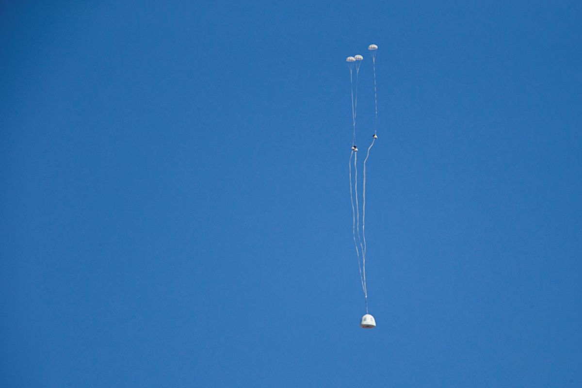
After stabilizing the crew capsule, the drogue parachutes extract the main parachutes for landing.
Credit: Blue Origin
New strategy
“Though wings and parachutes have their adherents and their advantages, I’m a huge fan of rocket-powered vertical landing,” Bezos said.
Data from last November’s mission, Bezos added, “matched our preflight predictions closely, which made preparations for today’s re-flight relatively straightforward.”
Bezos said that, thanks to new software, rather than the vehicle translating to land at the exact center of the pad, it now initially targets the center, but then sets down at a position of convenience on the pad, prioritizing vehicle attitude ahead of precise lateral positioning.
“New Shepard landings show this new strategy increases margins, improving the vehicle’s ability to reject disturbances created by low-altitude winds,” Bezos explained.

Blue Origin’s New Shepard booster executes a controlled vertical landing at 4.2 mph.
Credit: Blue Origin
Orbital vehicle
Bezos made note of work on Blue Origin’s orbital vehicle.
“We’re already more than three years into development of our first orbital vehicle,” Bezos advised. “Though it will be the small vehicle in our orbital family, it’s still many times larger than New Shepard. I hope to share details about this first orbital vehicle this year.”
Check out the posted video of the new test flight at:

Mars true-color globe showing Terra Meridiani.
Credits: NASA/Greg Shirah
A crew of Chinese volunteers will take part in a 180-day isolation study to mimic a human mission to Mars.
According to a January 21 report by the state-run People’s Daily, the four volunteers will be confined within a space capsule consisting of six giant “boxes” constructed by China’s Southern Research Institute of Space Technology.
The six giant boxes involve a low pressure tank, two plant tanks, a resources tank, a life support cabin and a crew cabin.
Capsule details
The crew cabin is 8.2 meters, or three stories high, and the minimum height of all the boxes is some 12 feet (3.6 meters).
The 180 cubic meters provided for the volunteers in the crew cabin is divided into nine parts, including a sleeping area, working and reading areas, cafeteria, gym and medical monitoring area, explains the People’s Daily.
Vegetables, fruits, staple crops and oil plants are cultivated within the 674 cubic meters of the plant tank.
In the resources tank, recycling and purification systems will deal with waste, including human waste, plant debris, waste water and exhaust gas.
Within in the life support area, food is to be stored and processed, and there is a water supply system and air purification system.

High-level experiments
The volunteers are to start the experiment after Spring Festival, with no specific time identified. Chinese New Year — also called Spring Festival — falls on February 8 this year.
The three men and one woman will experience 180 days of isolated life together and conduct more than 20 high-level experiments, including simulation of a journey to Mars, and the establishment of a base station on Mars, according to the People’s Daily report.

