Archive for the ‘Space News’ Category
 Author:
 January 9th, 2017

Virgin Galactic’s VSS Unity in trial run for creating suborbital space travel.
Credit: Virgin Galactic
Fodor’s Travel offers expert travel advice for every stage of a traveler’s trip. They provide travel recommendations for all tastes and budget in over 7,500 worldwide destinations.
But curb that travel taste for leaving Earth!
The organization has posted their “Fodor’s No List 2017” spotlighting citizen space travel as a kind of no fly zone.
Cold, dark vacuum
Tagging it “UNDER DEVELOPED: SPACE” the travel advisory group offers this view:
“The desire to go to space is entirely understandable. Between Zika, the bleaching of the Great Barrier Reef, and obnoxious spring breakers alone, who wouldn’t want to set a course for that cold, dark vacuum? Plus, you’d be part of an exclusive club: only 536 people have ever been to space, with only 24 traveling beyond low Earth orbit.”

Travel opportunities…or keep your feet firmly planted on Earth?
Credit: ISECG
However, they flag the fact that a seat on Virgin Galactic’s suborbital spaceliner goes for a cool $250,000 and advises: “You’d better be Richard Branson himself. Even if you did have the funds for a ticket, you could buy a perfectly lovely house outright, never mind the luxurious vacations you could take right here on planet Earth!”
South pole position
Fodor’s guidance is to put your space helmet away and pack your bags for Antarctica.
“If you’re looking to ‘get away from it all,’ a trip to this continent-sized tundra will help you achieve that in the most literal way possible,” they counsel. Plus, you’ll still have all the thrill of visiting a remote, isolated locale without the house-sized price tag. Because Zika and climate change aside, there are still plenty of incredible corners of this pale blue dot just waiting to be explored.”

Australian continent and Antarctica captured by Hayabusa2 camera.
Credit: JAXA
Dubious destinations
So for Earth-bound travelers, take note that on the Fodor no list is Dubai, an “under construction” travel stop. Instead go to Hong Kong.
Forget Miami Beach due to the Zika virus…but thumbs up on Key West.
Another dubious destination listed includes New Delhi where a traveler is greeted by the thick smoke suffocating the city. “On bad days, visibility is just a few yards,” Fodor warns. Instead, go to Bangalore.
For the complete listing of Fodor’s destinations in 2017 to avoid, go to:
http://www.fodors.com/news/photos/fodors-no-list-2017
 Posted in


China’s first commercial carrier rocket departs the Jiuquan Satellite Launch Center, northwest China.
Credit: CCTV-Plus
China has successfully launched its first commercial carrier rocket – the Kuaizhou-1A (KZ-1A) (“Fast Vessel”) – sending a trio of satellites into orbit.
The January 9th flight of the solid-fuel launcher took place at the Jiuquan Satellite Launch Center, northwest China.
Short launch prep
“Today’s launch was its maiden voyage. It is a low-cost carrier rocket with short pre-launch preparation and is capable of delivering its 300-kilogram payload to the near-Earth orbit,” said Zhang Di, vice-president of the China Aerospace Science and Industry Corporation (CASIC) Fourth Academy in a CCTV-Plus report.
Zhang said that the three spacecraft in one liftoff comprised the JL-1-03, a smart video satellite, while XY-S1 and Caton-1 are both CubeSats weighing between two and three kilograms.
Satellite duties
According to CCTV-Plus, the JL-1 is capable of providing high-definition video images useful for land resources and forestry surveying, environmental protection, transport and disaster prevention and relief purposes.
The XY-S1 and Caton-1 satellites are experimental satellites to test technologies of low-orbit narrow-band communication and VHF Data Exchange System (VDES), respectively.
The XY-S1 and Caton-1 satellites are experimental satellites to test technologies of low-orbit narrow-band communication and VHF Data Exchange System (VDES) respectively.
Eyeing the market
A rocket technology company under the CASIC is responsible for Monday’s launch mission.
According to a CASIC statement, the success of the mission marks the company’s capability of providing flexible, convenient, quick-to-launch and economical launch vehicles for domestic and overseas clients.
To view the CCTV-Plus video noting the launch, go to:
http://l3-pv.news.cctvplus.com/2017/0109/8040476_Preview_1483967496658.mp4

Curiosity Front Hazcam Left B image taken on Sol 1572, January 7, 2016.
Credit: NASA/JPL-Caltech
NASA’s Curiosity Mars rover is presently working in Sol 1572 mode, driving roughly 55 feet (17 meters) on the previous sol.
The robot is now at a location with bedrock outcrops in its robotic arm workspace, explains Ken Herkenhoff of the USGS Astrogeology Science Center in Flagstaff, Arizona.
Wind sensor booms
The weekend plan for Curiosity “includes lots of arm work as well as remote observations,” reports Herkenhoff.
That plan for Sol 1572 includes use of the Mars Hand Lens Imager (MAHLI) to take images of the Rover Environmental Monitoring Station (REMS) booms to diagnose recent problems with the rover’s wind sensors.

Self-inspection of wind sensor booms. Curiosity took this Mars Hand Lens Imager (MAHLI) image on Sol 1572, January 7, 2017.
MAHLI is located on the turret at the end of the rover’s robotic arm.
Credit: NASA/JPL-Caltech/MSSS
“Some of the wind sensors on one boom have not functioned since landing, and sensors on the other boom have been acting up lately,” Herkenhoff notes. Later on the schedule is for MAHLI imagery to be taken of a yellow/red color boundary at “Greenstone” and a full suite of images of a yellow bedrock target named “Isle Au Haut.”
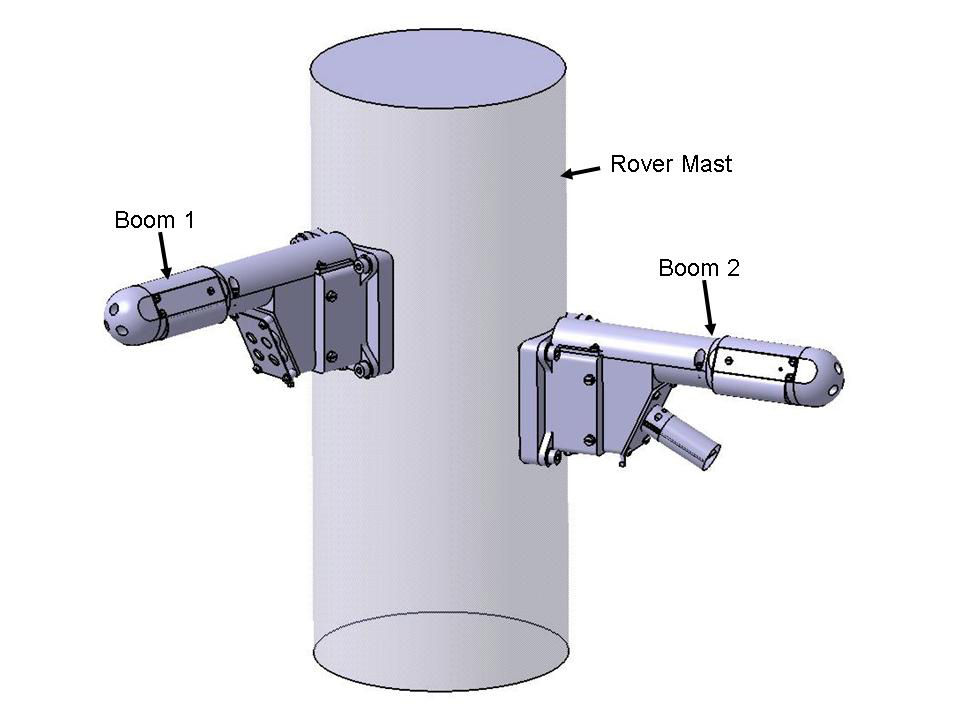
Two small booms on the rover mast record the horizontal and vertical components of wind speed to characterize air flow near the Martian surface from breezes, dust devils, and dust storms.
Credit: NASA/JPL-Caltech/INTA (Instituto Nacional de Tecnica Aeroespacial)
The Alpha Particle X-Ray Spectrometer (APXS) device is then to be placed on Isle Au Haut for an overnight integration.
Dust measurements
Early on the morning of Sol 1573, the scripted plan is to use the rover’s Navcam to search for clouds and Mastcam is to measure the amount of dust in the air by imaging the Sun and the distant crater rim.
“These dust measurements will be repeated at two other times of day later that sol,” Herkenhoff adds.
Later on that sol morning, the Chemistry & Camera (ChemCam) is slated to acquire passive — no laser — observations of its calibration target.
Drill diagnostics
Then the rover’s robot arm is to tasked again to perform new diagnostic tests of the drill feed mechanism, “to help us understand whether the drill feed stall is more sensitive to rotary-only or percussive drilling,” Herkenhoff reports.
“The test data acquired to date indicate an intermittent problem with the internal brake within the motor that feeds the drill forward and backward relative to the rest of the turret,” he explains. “Fortunately, we are able to do everything except drilling while the investigation continues.”
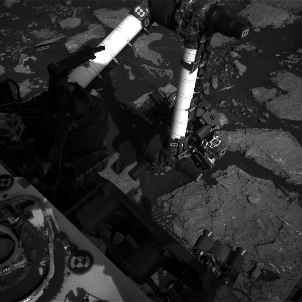
Curiosity Navcam Left B image taken on Sol 1572, January 7, 2017.
Credit: NASA/JPL-Caltech
The team has decided not to try again to drill at Precipice, and to continue driving up the flank of Aeolis Mons – “Mount Sharp”.
Herkenhoff says that after the drill tests, ChemCam will perform some more calibration activities, and acquire laser-induced breakdown spectroscopy (LIBS) data on Greenstone and a bedrock exposure called “Birch Harbor Mountain.”
On tap following that activity is for the rover’s Right Mastcam to image these targets and bright vein targets dubbed “Tarrantine” and “Flying Mountain.”
Drive ahead
On Sol 1574, ChemCam and the rover’s Right Mastcam are scheduled to observe Isle Au Haut before the rover drives away.

Curiosity Mastcam Left image taken on Sol 1571, January 6, 2017.
Credit: NASA/JPL-Caltech/MSSS
After wheeling away, the Curiosity’s arm will be unstowed and the robot’s Navcam will take a stereo pair of images of the arm workspace to prepare for possible contact science on Sol 1575.
Herkenhoff concludes: “It will be another busy weekend for our intrepid rover!”
As always, planned rover activities are subject to change due to a variety of factors related to the Martian environment, communication relays and rover status.

Curiosity Front Hazcam Left B image taken on Sol 1571, January 6, 2017.
Credit: NASA/JPL-Caltech
The NASA Curiosity Mars rover is now in Sol 1571, with ground controllers ready to drive the robot from its investigation of “Old Soaker.”
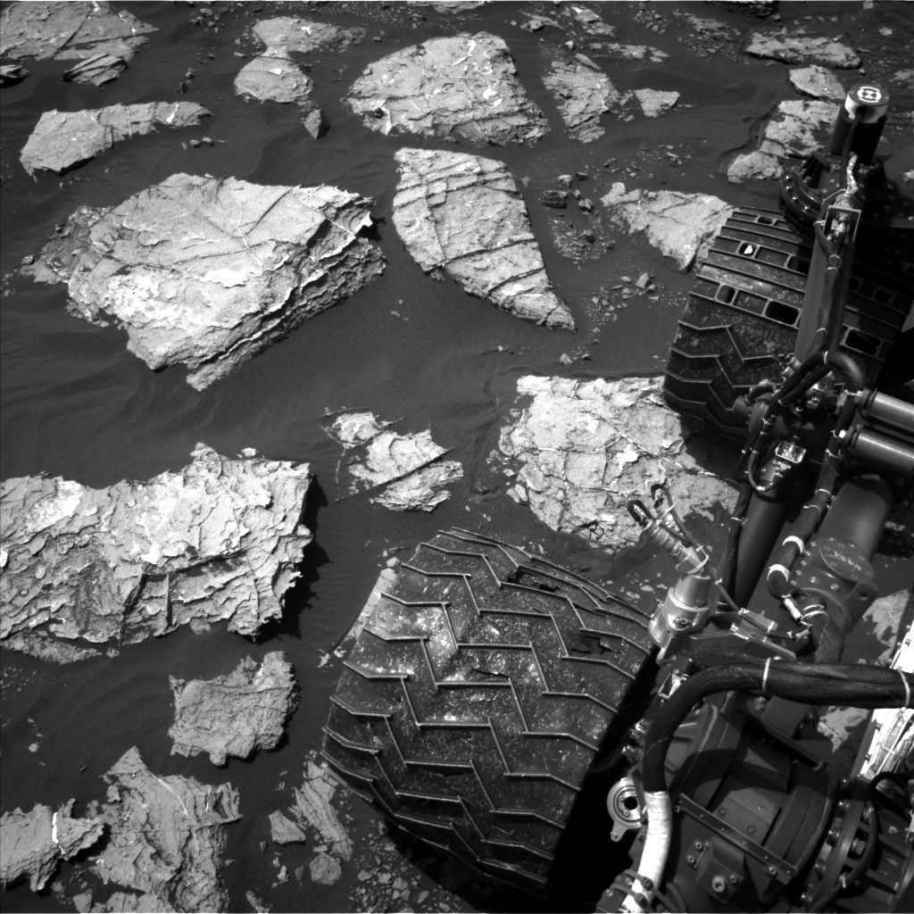
Curiosity Navcam Left B image taken on Sol 1571, January 6, 2017.
Credit: NASA/JPL-Caltech
Ken Herkenhoff of the USGS Astrogeology Science Center in Flagstaff, Arizona reports that prior to the drive, the plan calls for Chemistry & Camera (ChemCam) and Right Mastcam observations of darker bedrock patches named “Gilley Field” and “Fresh Meadow” and a dark clast called “North Bubble.”

Curiosity Mars Hand Lens Imager (MAHLI) image acquired on Sol 1570, January 5, 2017. MAHLI is located on the turret at the end of the rover’s robotic arm.
Credit: NASA/JPL-Caltech/MSSS
Dark spherule
The rover’s Mastcam is also slated to acquire a multispectral set of images of a dark spherule dubbed “Greening Island” before the drive, Herkenhoff adds.
“After the drive, the arm will be unstowed to allow Navcam and Left Mastcam to take pictures of the area in front of the rover to aid planning for this weekend,” Herkenhoff notes.

Curiosity Mars Hand Lens Imager (MAHLI) image acquired on Sol 1570, January 4, 2017. MAHLI is located on the turret at the end of the rover’s robotic arm.
Credit: NASA/JPL-Caltech/MSSS
Curiosity’s Navcam is also set to search for dust devils and clouds, “then the rover will sleep overnight and recharge her batteries,” Herkenhoff concludes.

“Old Soaker” is imaged by Curiosity’s Mastcam Right camera on Sol 1568, January 3, 2017.
Credit: NASA/JPL-Caltech/MSSS
NASA’s Curiosity Mars rover is now busy at work in Sol 1569 – holidays behind, scientists controlling the robot are back to daily planning.
Sol 1569 plans for the rover involve the investigation of ridge/fracture patterns at “Old Soaker,” reports Ken Herkenhoff of the USGS Astrogeology Science Center in Flagstaff, Arizona.
Ridges, clouds
First, Curiosity’s Chemistry and Camera (ChemCam) and Mastcam will observe the ridges at “Beech Mountain” and Navcam will search for clouds.

Curiosity Navcam Right B image taken on Sol 1569, January 4, 2017.
Credit: NASA/JPL-Caltech
Then the plan tags use of the Mars Hand Lens Imager (MAHLI) to take close-up images of a grey patch named “Eagle Lake” and a full suite of images of Beech Mountain.
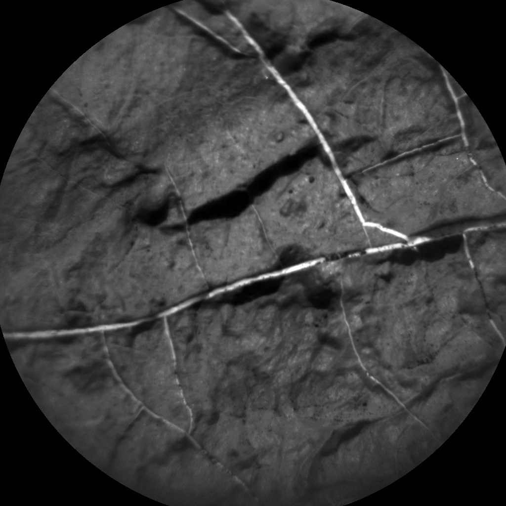
Curiosity ChemCam Remote Micro-Imager photo acquired on Sol 1569, January 4, 2017.
Credit: NASA/JPL-Caltech/LANL
MAHLI is also to acquire images from 25 cm and 5 cm of an area without ridge patterns dubbed “Hodgdon Pond” and another interesting feature called “Huguenot Head,” as well as a single oblique image of “Squeaker Cove” from 15 cm.
Good contact science
Herkenhoff notes that the robot’s Alpha Particle X-Ray Spectrometer (APXS) will be placed on Beech Mountain for a short integration, then on Eagle Lake for an overnight integration.
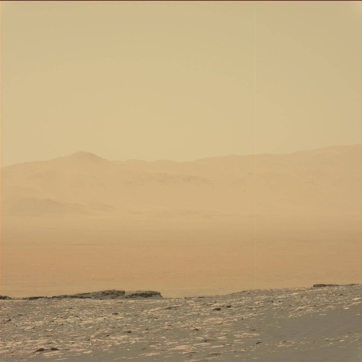
Curiosity Mastcam Left image taken on Sol 1568, January 3, 2017.
Credit: NASA/JPL-Caltech/MSSS
Concludes the USGS’s Herkenhoff: “Lots of good contact science to start the new year!”
Credit: CSIS
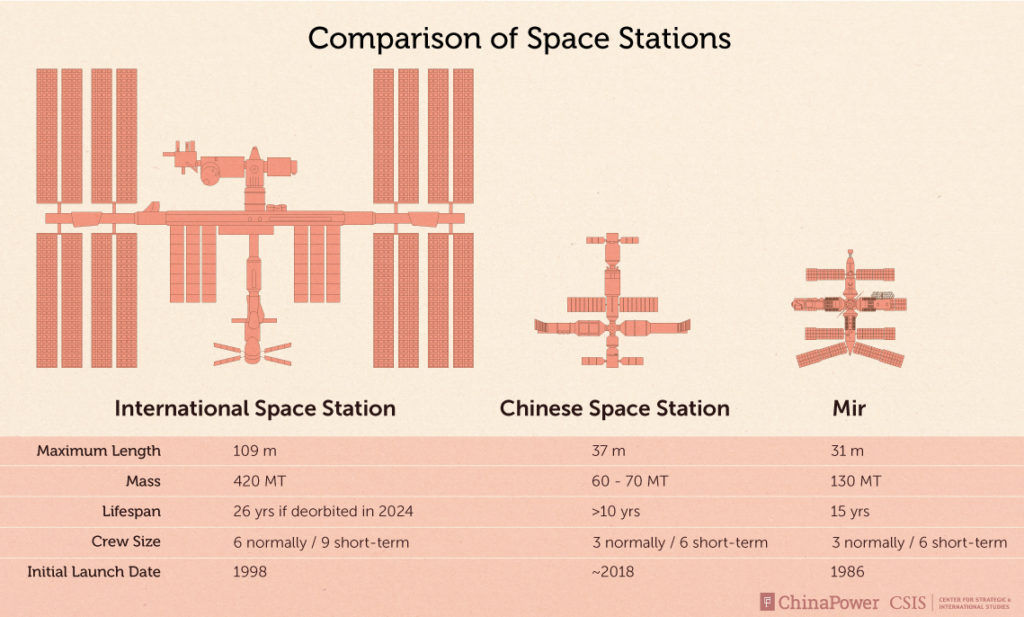
A Chinese Space Station (CSS) will support their long-term goals for space exploration, including missions to the Moon and Mars.

Courtesy: CSIS
This overview offers insight into the development of the CSS, compares China’s space station with those of other countries, and explores how China may use piloted space missions to bolster domestic innovation.
Go to this informative overview by the Center for Strategic & International Studies at:

New White House document deals with the threat of Near Earth Objects (NEOs).
Credit: NASA
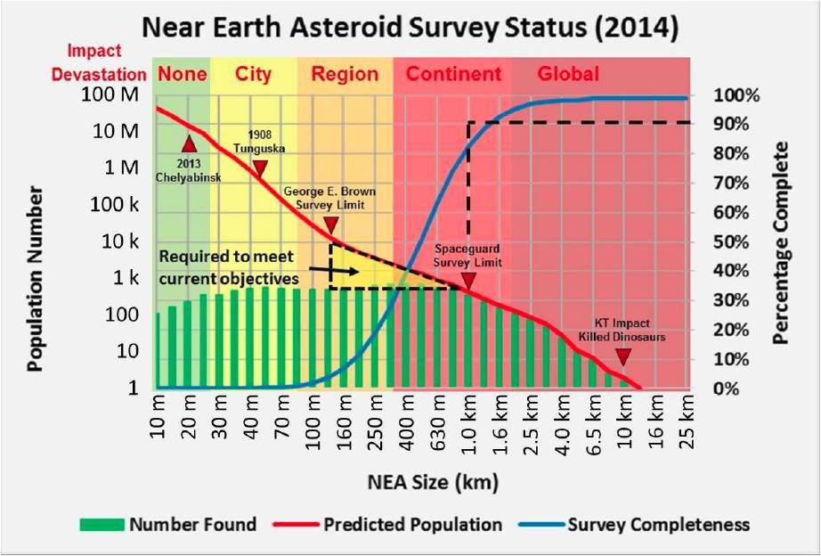
The White House has released a National Near-Earth Object Preparedness Strategy – a document developed by the Interagency Working Group (IWG) for Detecting and Mitigating the Impact of Earth-bound Near-Earth Objects (NEOs) (DAMIEN).
According to the strategy document it “seeks to improve our Nation’s preparedness to address the hazard of near-Earth object (NEO) impacts by enhancing the integration of existing national and international assets and adding important capabilities that are currently lacking.”
The Strategy builds on efforts at the National Aeronautics and Space Administration (NASA) to better detect and characterize the NEO population as well as recent efforts at the Department of Homeland Security (DHS) to prepare for and respond to a NEO impact.
Credit: OSTP
The document was published by White House Office of Science and Technology Policy.
Seven strategic goals
As detailed in the strategy, there are seven strategic goals that underpin the effort to enhance the Nation’s preparedness to NEO impacts:
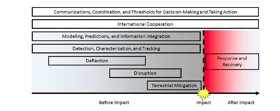
Enhance NEO Detection, Tracking, and Characterization Capabilities. Objectives include: developing a capability roadmap to inform a strategy for investing in both U.S. and foreign abilities for detection, tracking, and characterization; improving observation capabilities for more complete and rapid observation of the entire population of NEOs; and updating existing observatories with capabilities to improve characterization assessments.
Develop Methods for NEO Deflection and Disruption. Objectives include: developing capabilities for fast-response focused reconnaissance and characterization; researching deflection and disruption capabilities for NEOs of varying size, mass, composition, and impact warning times; and researching technologies required for deflection and disruption concepts.
Improve Modeling, Predictions, and Information Integration. Objectives include: ensuring that adequate modeling capabilities are developed for each topical need, especially for modeling NEO trajectories to reduce orbit uncertainties and predicted impact effects; determining what outputs are required by whom; and establishing an organizational construct to coordinate the development and dissemination of modeling results.
Develop Emergency Procedures for NEO Impact Scenarios. Objectives include: promoting a collaborative national approach to defend against, mitigate, respond to, and recover from a NEO impact event; and developing coherent national and international communication strategies to facilitate NEO impact preparations.
Establish NEO Impact Response and Recovery Procedures. Objectives include: establishing national and international protocols to efficiently respond to a NEO impact, whether in deep ocean, coastal regions, or on land; and facilitating international cooperation and planning to recover from a NEO impact in a timely manner with minimal disruption.
Leverage and Support International Cooperation. Objectives include: building international support and policies for acknowledging and addressing the potential Earth impact of a NEO as a global challenge; fostering consultation, coordination, and cooperation channels and efforts for the planning for, impact emergency preparedness before, and response to a NEO impact; increasing engagement with the international community on observation infrastructure, data sharing, numerical modeling, and scientific research; strengthening international coordination and cooperation on NEO data and National Near-Earth Object Preparedness Strategy analyses; and promoting a collaborative international approach to preparedness for NEO events.
Establish Coordination and Communications Protocols and Thresholds for Taking Action. Objectives include: coordinating the communication of detected impact threats within the U.S. Government, as well as with other governments, media, and the public; developing a set of thresholds to aid U.S. decisions in whether to implement deflection or disruption missions; developing decision flowcharts for NEO hazard scenarios incorporating bench-marks and decision thresholds; and developing protocols for international interactions regarding NEO impacts outside of U.S. territory.
These seven high-level goals and associated objectives outlined in the Strategy are intended to support a collaborative and Federally-coordinated approach to developing effective policies, practices, and procedures for decreasing the Nation’s vulnerabilities associated with the NEO impact hazard.
Credit: OSTP
Significant and complex challenge
In a concluded statement, the Strategy document notes that, as with other low-probability, high-consequence hazards “potential NEO impacts pose a significant and complex challenge.”
The Strategy is seen as “a step in addressing the myriad challenges of managing and reducing the risks posed by both large and small NEOs.”
To read the full document, National Near-Earth Object Preparedness Strategy, go to:

Credit: CCTV-Plus
The first Moon-sample return to Earth mission in over four decades is being readied for launch by China.
Chinese engineers are completing work on the Chang’e-5 lunar mission for a launch later this year. If successful, this robotic spacecraft would attempt the first lunar sample return to Earth in over 40 years.
Historical notes
The former Soviet Union successfully executed three robotic sample return missions: Luna 16 returned a small sample (101 grams) from Mare Fecunditatis in September of 1970; February 1972, Luna 20 returned 55 grams of soil from the Apollonius highlands region; Luna 24 retrieved 170.1 grams of lunar samples from the Moon’s Mare Crisium (Sea of Crisis) for return to Earth in August 1976.
Ascender
According to Chinese news services, Chang’e-5 is comprised of four parts including the orbiter, ascender, lander, and Earth reentry module.
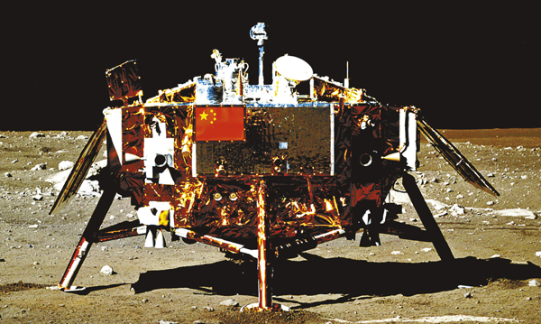
China’s Chang’e 3 Moon lander, imaged by Yutu lunar rover.
“The lander and ascender form a combination that will land on the Moon to conduct unmanned sample collection mission,” said Ruan Jianhua, deputy chief designer of China’s Chang’e-5. The lunar samples will be shot back to the Earth contained within the mission’s reentry module.
“We will later conduct research of Mars and other asteroids. We expect to go further in the exploration of deep space,” said Ruan via a CCTV-Plus interview.
Endless exploration
The first stage of China’s lunar expedition program was achieved by sending Chang’e 1, a circumlunar satellite, in 2007. China landed its first lunar probe Chang’e 3 on the surface of the moon in 2013.

China’s robotic circumlunar test flight snapped this image of the Moon with Earth in the distance.
Credit: Chinese Academy of Sciences
Last year, Tian Yulong, chief engineer of the State Administration of Science, Technology and Industry for National Defense (SASTIND) noted that “lunar exploration is endless.”
Tian said the Chang’e 5 is headed for finishing the third step of “going around, landing and returning.”
“But it doesn’t mean the exploration will cease,” Tian said.
Far side next
Space officials in China are also planning to be the first country to land on the far side of the Moon.
That mission is to be carried out by Chang’e-4, a backup for China’s Chang’e-3 spacecraft, and is due for launch in 2018.
“Our exploration has purposes and goals,” Tian said.

Following a circumlunar voyage in 2014, a return capsule parachuted to Earth. This test was a prelude to China’s Chang’e-5 lunar mission being readied for its return sample mission later this year.
Courtesy: China Space
Long-term path
According to Tian: “We have preliminarily conducted the demonstration of medium-to-long term development path of the Moon-probing system and also proposed to carry out a series of activities with distinctive features including the exploration of the Moon’s north and south poles after special tasks are completed.”
Tian said that China is in discussion with the European Space Agency and other countries “to build bases and carry out scientific investigations on the Moon, which will lay a technology and material foundation for human beings’ landing on the Moon in the future.”
For a behind-the-scenes look at getting China’s Chang’e-5 ready for its lunar mission, go to this CCTV-Plus video:
http://cd-pv.news.cctvplus.com/2016/1231/8039831_Preview_1806.mp4

Credit: NASA
This week there’s an impressive gathering of astronomers at the 229th meeting of the American Astronomical Society (AAS). The celestial confab is taking place January 3-7 in Grapevine, Texas.
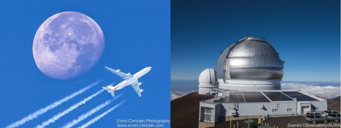
Along with a host of papers and speakers is a special AAS session on “Geoengineering the Atmosphere to Fight Climate Change: Should Astronomers Worry about It?”
Growing concern
The session is hosted by the AAS Sustainability Committee on the issue that may be of growing concern to astronomers.
As defined by the committee, “geoengineering” — or large-scale engineering plans to modify the atmosphere in an attempt to offset the effects of global warming, such as by injecting aerosols globally to reflect sunlight.
Credit: AAS Sustainability Committee
Several researchers studying geoengineering, including astronomers, will present widely divergent views on the merits and risks of geoengineering and other climate interventions, both for ground-based astronomy, which of course must gaze through the atmosphere, and for the long-term stability of the Earth’s climate system.
Environmental impact
The mission of the AAS Sustainability Committee is “to inform and support AAS members in matters relating to the environmental impact of our work and provide facts, information and recommendations to its members for engaging in dialogue with students, colleagues and the broader world community.”
For more information on the overall AAS meeting, go to:
https://aas.org/meetings/aas229
For additional information on the AAS Sustainability Committee, go to:

Features called recurring slope lineae (RSL) have been spotted on some Martian slopes in warmer months. Some scientists think RSL could be seasonal flows of salty water. Red arrows point out one 0.75-mile-long (2 kilometers) RSL in this image taken by NASA’s Mars Reconnaissance Orbiter.
Credit: NASA/JPL-Caltech/Univ. of Arizona
A major Mars finding in recent years has been discovery of recurring slope lineae in certain areas of the Red Planet. These dark fingers of mystery – RSL in Mars shorthand — emerge from steep, rocky exposures. They incrementally grow, fade, and reform on a seasonal basis.
What RSL truly represent is debatable, but some researchers say they are suggestive that liquid water occurs on or near the surface of Mars today.
Question: Do RSL make noise?
Listen up
NASA’s 2020 Mars rover is to carry special cameras and microphones to capture stunning views and sounds, and not just its barnstorming entry and descent toward the Red Planet.
If the robot achieves a safe touchdown, the rover’s onboard microphones could put an ear to Mars, adding to the ambience of exploration.
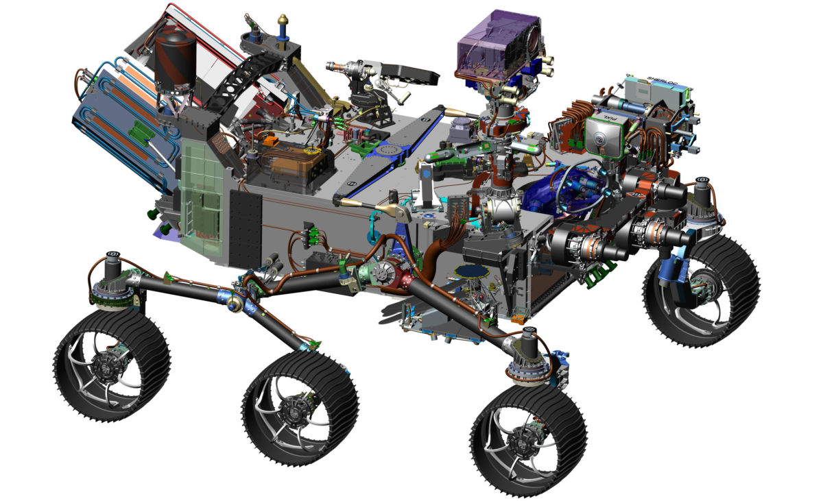
The listening robot. New computer generated image of Mars 2020 rover.
Credit: NASA/JPL/Caltech
The future rover’s landing site has yet to be chosen…and given the gift of hearing, just what could its microphones pick up?
In an interview I did last year with Matthew Wallace, Mars 2020 rover deputy project manager at NASA’s Jet Propulsion Laboratory in Pasadena, California, he said the sounds of rover wheels trekking across the planet, the drill drilling, and rover’s mast moving are likely to be heard. High-speed wind bursts too.
From a distance
Any hope of hearing RSL?
“Probably not much…like grain flows, maybe some faint hissing or popping sounds?”
That’s the response from Alfred McEwen, a planetary geologist and director of the Planetary Image Research Laboratory at the University of Arizona in Tucson. He is the principal investigator of the High Resolution Imaging Science Experiment (HiRISE) for NASA’s Mars Reconnaissance Orbiter.
HiRISE has been the major tool in stimulating an “outpouring” of interest in RSL.
While HiRISE observations of RSL have been interpreted as present-day, seasonally variable liquid water flows, Mars-orbiting spectroscopy of the features has not confirmed the presence of liquid water, only hydrated salts.
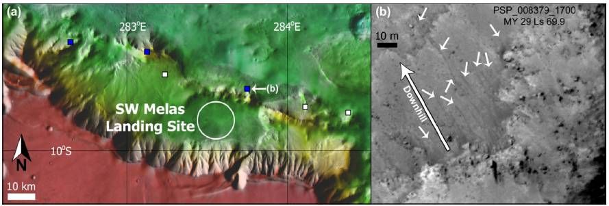
Candidate RSL near the potential SW Melas Mars 2020 rover landing site – one of eight now under review.
Credit: D.E. Stillman et al.
Planetary protection
Whatever they are, say a rover is safely positioned near RSL activity, what’s the chance of hearing and seeing RSL in action?
Such a circumstance is moot as a rover won’t go near any candidate RSL due to NASA planetary protection rules. Where there is water, so too there may be microbial life.
“They probably make a little bit of noise, but the Mars 2020 probably could not hear it as it would be too far away,” said David Stillman, senior research scientist at the Southwest Research Institute in Boulder, Colorado.
Atmospherics
Adds John Rummel, a senior scientist at the SETI Institute with a distinguished track record in astrobiology and planetary protection issues:
“My guess is that you could get noise produced by a group of RSL,” Rummel said, “much the way that you can hear water running under a group of aspen in a small copse in the mountains in spring, even though it is hard to identify exactly where the noise is coming from.”
A copse is a thicket of bushes or a small stand of trees.

NASA Mars Reconnaissance Orbiter’s HiRISE image of recurring slope lineae in Melas Chasma, Valles Marineris. Arrows point out tops and bottoms of a few lineae.
Credit: NASA/JPL-Caltech/University of Arizona
But how far that noise could be received with such a small amount of atmosphere on Mars, “remains to be heard,” Rummel told Inside Outer Space.
“I would guess that you wouldn’t hear anything much, even if the noise were being produced right next to you. There is just not enough atmosphere to carry the sound,” Rummel added. “Sales figures for picnic boom-boxes on Mars will be slow, at first!”
All ears, eyes
For more information on how the Mars robot will be “all ears and eyes,” go to my Space.com story:
Mic’d Up on Mars! 2020 Rover Will Capture Sounds of Red Planet
August 4, 2016 07:00am ET
http://www.space.com/33637-nasa-mars-2020-rover-microphone.html

