Archive for the ‘Space News’ Category

Curiosity Navcam Left B image taken on Sol 1578, January 13, 2017.
Credit: NASA/JPL-Caltech
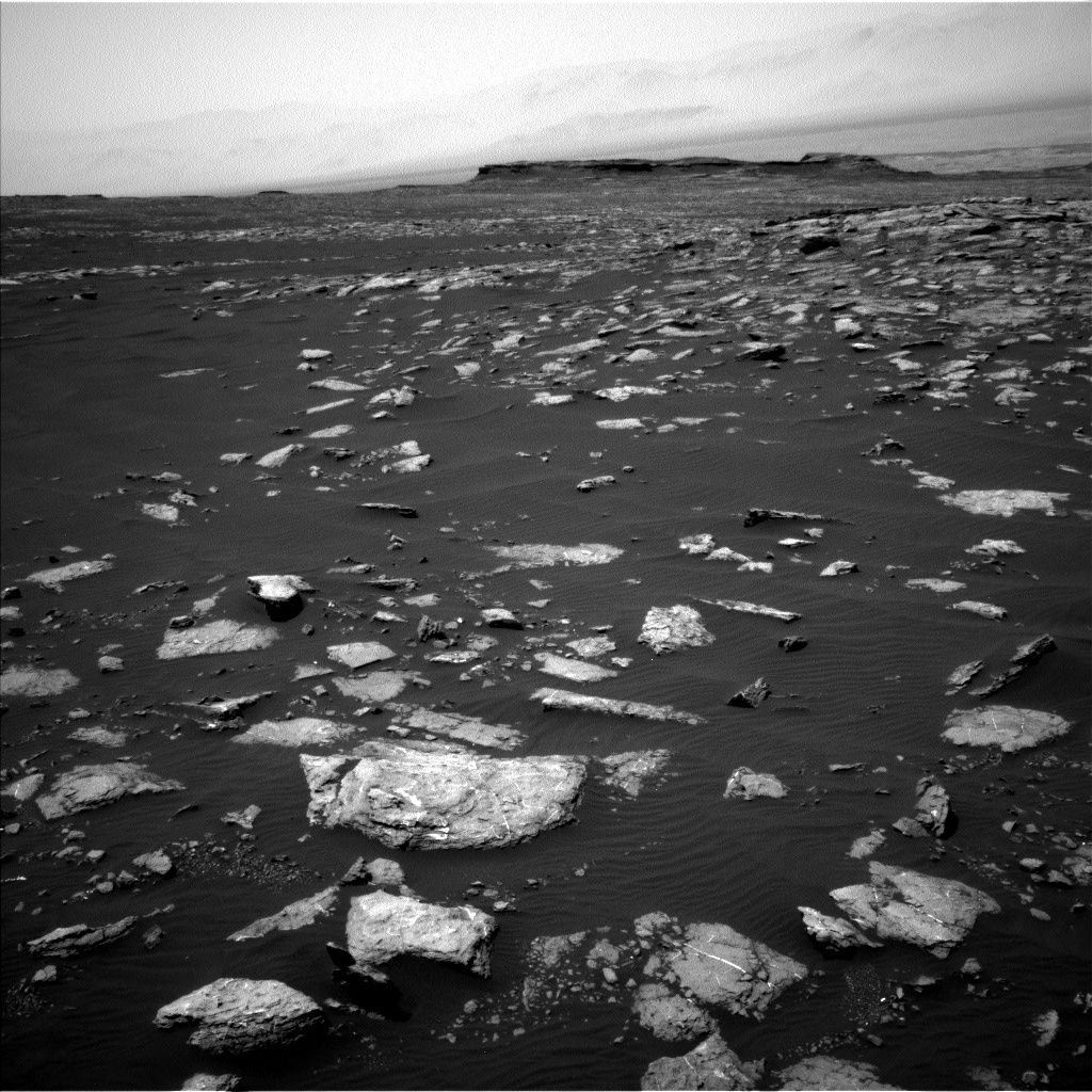
NASA’s Curiosity Mars rover is working through a roster of science duties on Sol 1579.
Rover scientists have put together a 4-sol plan following a drive of the robot of over 80-feet (25-meters) across the Red Planet’s landscape.

Curiosity Navcam Left B image taken on Sol 1578, January 13, 2017.
Credit: NASA/JPL-Caltech
“Curiosity is surrounded by more dark sand than usual, but there is enough rock exposed that we had a lot of science targets to choose from,” reports Ken Herkenhoff at the USGS Astrogeology Science Center in Flagstaff, Arizona.
Given the upcoming holiday on Monday, a 4 sol plan has been scripted: Sols 1579-1582.

Curiosity Mastcam Right image taken on Sol 1577, January 12, 2017.
Credit: NASA/JPL-Caltech/MSSS
Laser zapping
The first sol will include only Rover Environmental Monitoring Station (REMS) atmospheric observations while the rover recharges after a Sample Analysis at Mars (SAM) Instrument Suite methane measurement the night before.

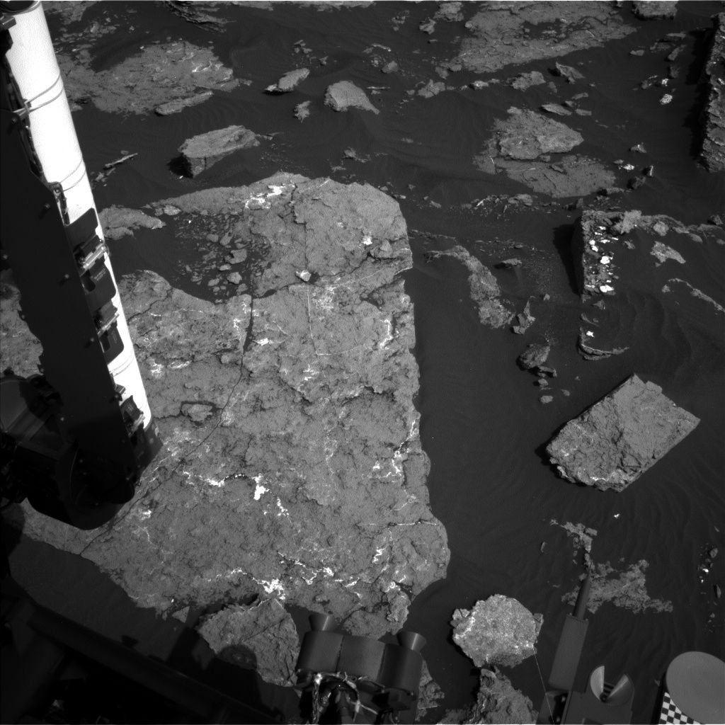
Curiosity Mars Hand Lens Imager (MAHLI) photo acquired on Sol 1578, January 13, 2017.
Credit: NASA/JPL-Caltech/MSSS
The Sol 1580 plan starts with Chemistry & Camera (ChemCam) passive (no laser) measurements of the sky and calibration targets.
“Then we’ll use the laser to zap rock targets “Oak Bay” and “Rockport” and take Right Mastcam images of them,” Herkenhoff notes.
Bedrock exposures
The rover’s Mastcam is also to acquire a mosaic of bedrock exposures just west of the rover, measure dust in the atmosphere, and take another image of the rover deck.
Later that afternoon, the plan calls for ChemCam and Right Mastcam observations of disturbed sand at “Kennebec,” an undisturbed ripple called “Spruce Top,” and bedrock targets named “Traveler” and “Mars Hill.”
Curiosity’s Right Mastcam is also to acquire a 3×1 mosaic of a more distant outcrop dubbed “Ogler Point.”

Odd object imaged by Curiosity’s Mastcam Right image taken on Sol 1577, January 12, 2017. Possibly new meteorite find?
Credit: NASA/JPL-Caltech/MSSS
Contact science
Herkenhoff reports that Sol 1581 is dominated by contact science, starting with a full suite of Mars Hand Lens Imager (MAHLI) images of Mars Hill.
MAHLI will also take close-up images of nearby “Camera Hill” and acquire a 3-image mosaic of the layered outcrop target “Small Falls.”
The Alpha Particle X-Ray Spectrometer (APXS) is to be placed on Camera Hill for a short integration, then on Mars Hill for an overnight integration.
Drive planned
On Sol 1582, Navcam will search for clouds and dust devils before the rover drives away.
Following the drive, the Autonomous Exploration for Gathering Increased Science software, AEGIS for short, will again be used to autonomously select a ChemCam target and acquire data, and the Mars Descent Imager (MARDI) is slated to take another image during twilight.
“Finally, the rover will get some well-earned rest overnight,” Herkenhoff concludes.

Curiosity Mars rover location as of Sol 1576.
Credit: NASA/JPL-CALTECH/Univ. of Arizona
New map
A new map has been issued showing the Curiosity rover’s location for Sol 1576.
The map shows the route driven by the robot through the 1576 Martian day, or sol, of the rover’s mission on Mars (January 12, 2017).
Numbering of the dots along the line indicate the sol number of each drive. North is up.
From Sol 1574 to Sol 1576, Curiosity has driven a straight line distance of about 96.45 feet (29.40 meters). Since touching down in Bradbury Landing in August 2012, Curiosity has driven 9.38 miles (15.10 kilometers).
The base image from the map is from the High Resolution Imaging Science Experiment Camera (HiRISE) onboard NASA’s Mars Reconnaissance Orbiter.

Global worry: Near-Earth Objects (NEOs).
Credit: Texas A&M
There is no doubt that big-time troublemakers lurk out there in the cosmos.
We know that blitzkrieging asteroids and comets can make for a bad day here on Earth. Our planet has been on the receiving end of long-ago scurrilous intruders…and has the pock marks to prove it.
In the waning days of U.S. President Barack Obama’s Administration, the White House Office of Science and Technology Policy (OSTP) released a “National Near-Earth Object Preparedness Strategy.” The document was tucked away under the reports and documents section of OSTP’s Cabinet-level National Science and Technology Council.
Hit squad
The bottom line fallout: There are NEOs that have cross-hairs on our world. But what to do about these cosmic demons from the deep is another matter.
To view my new Scientific American article on this topic, go to:
New White House Strategy Preps Earth for Asteroid Hit Scenarios
The Office of Science and Technology Policy has released a new plan for protecting Earth from hazardous space rocks

Curiosity Navcam Left B image taken on Sol 1576, January 11, 2017.
Credit: NASA/JPL-Caltech
NASA’s Curiosity Mars rover is now busy at work performing Sol 1577 duties.
The robot drove almost 100-feet (30-meters) on Sol 1576, stopping in a location with a nice exposure of bedrock in the arm workspace, reports Ken Herkenhoff of the USGS Astrogeology Science Center in Flagstaff, Arizona.

Optics check on Mars Hand Lens Imager (MAHLI).
Curiosity Mastcam Right image taken on Sol 1576, January 11, 2017.
Credit: NASA/JPL-Caltech/MSSS
Clean optics
The word is that the rover’s Mars Hand Lens Imager (MAHLI) optics look clean, so the plan called for a full suite of MAHLI images to be taken, along with a short Alpha Particle X-Ray Spectrometer (APXS) integration on a bedrock target named “Mansell Mountain.”
“Fitting the remote sensing observations we wanted, along with the contact science and a roughly 46-meter [150-foot] drive, into the Sol 1577 plan was a challenge,” Herkenhoff notes. “But the tactical team did a great job, working together to put together an excellent plan.”
Curiosity Navcam Left B image taken on Sol 1576, January 11, 2017.
Credit: NASA/JPL-Caltech
Odd cobble
After the contact science is completed, Curiosity’s Chemistry & Camera (ChemCam) and Right Mastcam will observe an odd cobble called “Ames Knob” and a bedrock target dubbed “Day Mountain.”
The rover’s Left Mastcam is set to acquire a 2-image mosaic of the bedrock slab in front of the rover, and Right Mastcam will take an image of the Sol 1576 Autonomous Exploration for Gathering Increased Science (AEGIS) target and a 4×1 mosaic of a layered exposure named “Appleton Ridge.”

Curiosity Mastcam Right image taken on Sol 1575, January 10, 2017.
Credit: NASA/JPL-Caltech/MSSS
After the rover’s drive and the post-drive imaging needed to plan Sol 1578 activities, Navcam will acquire a panorama and search for dust devils and clouds, Herkenhoff concludes.

Curiosity Navcam Left B image acquired on Sol 1575, January 10, 2017.
Credit: NASA/JPL-Caltech
Now in Sol 1576, NASA’s Curiosity Mars rover encountered an “arm fault” that prevented the Mars Hand Lens Imager (MAHLI) full suite from completing it task, leaving the camera close to the surface with its dust cover open.
The issue also precluded the robot from making planned remote science and driving duties, reports Ken Herkenhoff of the USGS Astrogeology Science Center in Flagstaff, Arizona.
“Fortunately, this fault has occurred before and is well understood, but recovering from the anomaly made for a rather hectic day,” Herkenhoff adds.

Curiosity Navcam Left B image acquired on Sol 1575, January 10, 2017.
Credit: NASA/JPL-Caltech
Exposed optics
A first order of business was to get MAHLI into a safe configuration, so the Sol 1576 plan starts with a single MAHLI image to look for evidence of dust on the exposed optics.
Front Hazcam images will be taken before and after MAHLI is retracted from the surface, then Right Mastcam will take a picture of MAHLI’s optics, again to look for dust contamination.
Finally, the MAHLI dust cover will be closed and Curiosity’s Alpha Particle X-Ray Spectrometer (APXS) device is to be placed on Dorr Mountain for a short integration.
Distant mesa
The plan calls for the arm to be stowed and Right Mastcam will acquire a 5×1 mosaic of a distant mesa named “Lobster Mountain.”
On the schedule is use of the Chemistry & Camera (ChemCam) and Right Mastcam to observe Dorr Mountain and a bedrock target dubbed “Parkman Mountain,” and Left Mastcam will take another image of the rover deck to monitor changes in the dust and sand on the deck, Herkenhoff reports.

Curiosity Mars Hand Lens Imager (MAHLI) photo acquired on Sol 1575, January 10, 2017.
Credit: NASA/JPL-Caltech/MSSS
Also on tap, the robot’s Mastcam is to measure the amount of dust in the atmosphere before the drive is attempted again.
Overnight recharging
“We don’t expect as much data as usual in time for planning the next Sol, so we had to carefully prioritize the post-drive imaging, which includes another Navcam stereo pair of the arm workspace,” Herkenhoff adds.
Later in the Sol, ChemCam is to autonomously observe a target selected by the Autonomous Exploration for Gathering Increased Science (AEGIS) software.

Curiosity Mastcam Right image taken on Sol 1574, January 9, 2017.
Credit: NASA/JPL-Caltech/MSSS
“Finally, the rover will recharge overnight to get ready for more fun on Sol 1577,” Herkenhoff concludes.
Planned rover activities are subject to change due to a variety of factors related to the Martian environment, communication relays and rover status.
Curiosity Navcam Left B image taken on Sol 1574, January 9, 2017.
Credit: NASA/JPL-Caltech
NASA’s Curiosity Mars rover is currently performing Sol 1575 duties.
Following a drive of over 80 feet (25-meters) on Sol 1574, the robot is again studying exposed bedrock in its robot arm workspace.
“To balance desires to sample the composition of the rocks along the traverse and to make good progress toward the south, contact science and another drive are both planned for Sol 1575,” reports Ken Herkenhoff of the USGS Astrogeology Science Center in Flagstaff, Arizona.
Knobbly bedrock
On the plan is use of rover’s Mars Hand Lens Imager (MAHLI) to acquire a full suite of images of a knobbly bedrock target named “Dorr Mountain.”

Curiosity Front Hazcam Left B image taken on Sol 1575, January 10, 2017.
Credit: NASA/JPL-Caltech
Then the arm will be stowed to allow Chemistry & Camera (ChemCam) to observe the same target, Herkenhoff notes, and for the Right Mastcam to acquire a 5×2 mosaic of the Dorr Mountain area.
Curiosity’s Navcam is also to search for dust devils before the drive begins.
Curiosity Navcam Left B image acquired on Sol 1575, January 10, 2017.
Credit: NASA/JPL-Caltech
After the drive, the arm will be unstowed to allow Navcam stereo imaging of the arm workspace, in anticipation of another “touch and go” plan in the works.

The first X-37B Orbital Test Vehicle waits in the encapsulation cell of the Evolved Expendable Launch vehicle on April 5, 2010 at the Astrotech facility in Titusville, Fla. Half of the Atlas V five-meter fairing is visible in the background.
Credit: U.S. Air Force
Hurled spaceward over a year and seven months ago, the puzzling United States Air Force’s X-37B space plane has winged past 600 days of operation in Earth orbit. It is just 75 days away from setting a programmatic milestone.
Known in military space speak as OTV-4 (Orbital Test Vehicle-4), this robotic mini-space plane was sent into Earth orbit on the program’s fourth clandestine flight on May 20, 2015.
Rocketed into orbit by a United Launch Alliance Atlas V rocket from Florida’s Cape Canaveral Air Force Station, just what this “winged warrior” is doing high above Earth is an on-going, tight-lipped affair.

A United Launch Alliance (ULA) Atlas V rocket successfully launched the U.S. Air Force X-37B space plane on May 20, 2015.
Credit: ULA
Moreover, how long the vehicle will remain in orbit is not known.
Milestone recordkeeping
The first OTV mission began April 22, 2010, and concluded on Dec. 3, 2010, after 224 days in orbit.
The second OTV mission began March 5, 2011, and concluded on June 16, 2012, after 468 days on orbit.
An OTV-3 mission chalked up nearly 675 days in orbit when it landed Oct. 17, 2014.
All the OTV craft have guided their way on auto-pilot to a Vandenberg Air Force Base, California tarmac-touchdown.
But that may change for OTV-4’s landing in the whenever.
Heading for Florida?
Just when and where the currently flying craft will wheel to a full-stop is unidentified.

Former shuttle processing area at the Kennedy Space Center has been overhauled by Boeing to prep the military’s secretive X-37B space plane.
Credit: Malcolm Glenn
What is known is that progress has been made on consolidating X-37B space plane operations, including use of NASA’s Kennedy Space Center (KSC) in Florida as a landing site for the robotic space plane.
A former KSC space-shuttle facility known as Orbiter Processing Facility (OPF-1) was converted into a structure that will enable the Air Force “to efficiently land, recover, refurbish and relaunch the X-37B Orbital Test Vehicle (OTV),” according to Boeing.
The X-37B vehicle development falls under the Boeing Space and Intelligence Systems in El Segundo, California, the firm’s center for all space and experimental systems and government and commercial satellites.
The Air Force Rapid Capabilities Office is leading the Department of Defense’s OTV initiative, by direction of the Under Secretary of Defense for Acquisition, Technology and Logistics and the Secretary of the Air Force.
Fleet size
To date, only two reusable X-37B vehicles have been confirmed as constituting the space plane “fleet.” Also, this current OTV-4 space trek is the second flight of the second X-37B vehicle built for the Air Force by Boeing.
Appearing like a miniature version of NASA’s now-retired space shuttle orbiter, the reusable military space plane is 29 feet (8.8 meters) long and 9.6 feet (2.9 meters) tall, and has a wingspan of nearly 15 feet (4.6 meters).
A previous X-37B being readied for launch atop Atlas booster.
Credit: Boeing
The space drone has a payload bay about the size of a pickup truck bed that can be outfitted with a robotic arm. It has a launch weight of 11,000 pounds (4,990 kilograms) and is powered on orbit gallium arsenide solar cells with lithium-ion batteries.
Payloads
Some payloads onboard the OTV-4 craft have been previously identified.
For example, Aerojet Rocketdyne has said that its XR-5A Hall Thruster had completed initial on-orbit validation testing onboard the X-37B space plane. Also onboard is a NASA advanced materials investigation.

Air Force X-37B robotic space plane is shown after Vandenberg AFB landing. Third mission of the program was the longest duration flight of the winged spacecraft. Now in orbit is the fourth mission of the space plane – and could shatter the previous time in orbit of this type of craft.
Credit: USAF/Boeing
That test-bedding of equipment on the winged space robot has been given high-marks by Winston Beauchamp, deputy undersecretary of the Air Force for Space.
“It remains a very useful way to test out things,” Beauchamp told Space.com last September during an American Institute of Aeronautics and Astronautics (AIAA) meeting in Long Beach, California. Asked about any interest in increasing the X-37B fleet size, he said that the number of vehicles in use is fine due to the pace of experiments it conducts.

Virgin Galactic’s VSS Unity in trial run for creating suborbital space travel.
Credit: Virgin Galactic
Fodor’s Travel offers expert travel advice for every stage of a traveler’s trip. They provide travel recommendations for all tastes and budget in over 7,500 worldwide destinations.
But curb that travel taste for leaving Earth!
The organization has posted their “Fodor’s No List 2017” spotlighting citizen space travel as a kind of no fly zone.
Cold, dark vacuum
Tagging it “UNDER DEVELOPED: SPACE” the travel advisory group offers this view:
“The desire to go to space is entirely understandable. Between Zika, the bleaching of the Great Barrier Reef, and obnoxious spring breakers alone, who wouldn’t want to set a course for that cold, dark vacuum? Plus, you’d be part of an exclusive club: only 536 people have ever been to space, with only 24 traveling beyond low Earth orbit.”

Travel opportunities…or keep your feet firmly planted on Earth?
Credit: ISECG
However, they flag the fact that a seat on Virgin Galactic’s suborbital spaceliner goes for a cool $250,000 and advises: “You’d better be Richard Branson himself. Even if you did have the funds for a ticket, you could buy a perfectly lovely house outright, never mind the luxurious vacations you could take right here on planet Earth!”
South pole position
Fodor’s guidance is to put your space helmet away and pack your bags for Antarctica.
“If you’re looking to ‘get away from it all,’ a trip to this continent-sized tundra will help you achieve that in the most literal way possible,” they counsel. Plus, you’ll still have all the thrill of visiting a remote, isolated locale without the house-sized price tag. Because Zika and climate change aside, there are still plenty of incredible corners of this pale blue dot just waiting to be explored.”

Australian continent and Antarctica captured by Hayabusa2 camera.
Credit: JAXA
Dubious destinations
So for Earth-bound travelers, take note that on the Fodor no list is Dubai, an “under construction” travel stop. Instead go to Hong Kong.
Forget Miami Beach due to the Zika virus…but thumbs up on Key West.
Another dubious destination listed includes New Delhi where a traveler is greeted by the thick smoke suffocating the city. “On bad days, visibility is just a few yards,” Fodor warns. Instead, go to Bangalore.
For the complete listing of Fodor’s destinations in 2017 to avoid, go to:
http://www.fodors.com/news/photos/fodors-no-list-2017

China’s first commercial carrier rocket departs the Jiuquan Satellite Launch Center, northwest China.
Credit: CCTV-Plus
China has successfully launched its first commercial carrier rocket – the Kuaizhou-1A (KZ-1A) (“Fast Vessel”) – sending a trio of satellites into orbit.
The January 9th flight of the solid-fuel launcher took place at the Jiuquan Satellite Launch Center, northwest China.
Short launch prep
“Today’s launch was its maiden voyage. It is a low-cost carrier rocket with short pre-launch preparation and is capable of delivering its 300-kilogram payload to the near-Earth orbit,” said Zhang Di, vice-president of the China Aerospace Science and Industry Corporation (CASIC) Fourth Academy in a CCTV-Plus report.
Zhang said that the three spacecraft in one liftoff comprised the JL-1-03, a smart video satellite, while XY-S1 and Caton-1 are both CubeSats weighing between two and three kilograms.
Satellite duties
According to CCTV-Plus, the JL-1 is capable of providing high-definition video images useful for land resources and forestry surveying, environmental protection, transport and disaster prevention and relief purposes.
The XY-S1 and Caton-1 satellites are experimental satellites to test technologies of low-orbit narrow-band communication and VHF Data Exchange System (VDES), respectively.
The XY-S1 and Caton-1 satellites are experimental satellites to test technologies of low-orbit narrow-band communication and VHF Data Exchange System (VDES) respectively.
Eyeing the market
A rocket technology company under the CASIC is responsible for Monday’s launch mission.
According to a CASIC statement, the success of the mission marks the company’s capability of providing flexible, convenient, quick-to-launch and economical launch vehicles for domestic and overseas clients.
To view the CCTV-Plus video noting the launch, go to:
http://l3-pv.news.cctvplus.com/2017/0109/8040476_Preview_1483967496658.mp4

Curiosity Front Hazcam Left B image taken on Sol 1572, January 7, 2016.
Credit: NASA/JPL-Caltech
NASA’s Curiosity Mars rover is presently working in Sol 1572 mode, driving roughly 55 feet (17 meters) on the previous sol.
The robot is now at a location with bedrock outcrops in its robotic arm workspace, explains Ken Herkenhoff of the USGS Astrogeology Science Center in Flagstaff, Arizona.
Wind sensor booms
The weekend plan for Curiosity “includes lots of arm work as well as remote observations,” reports Herkenhoff.
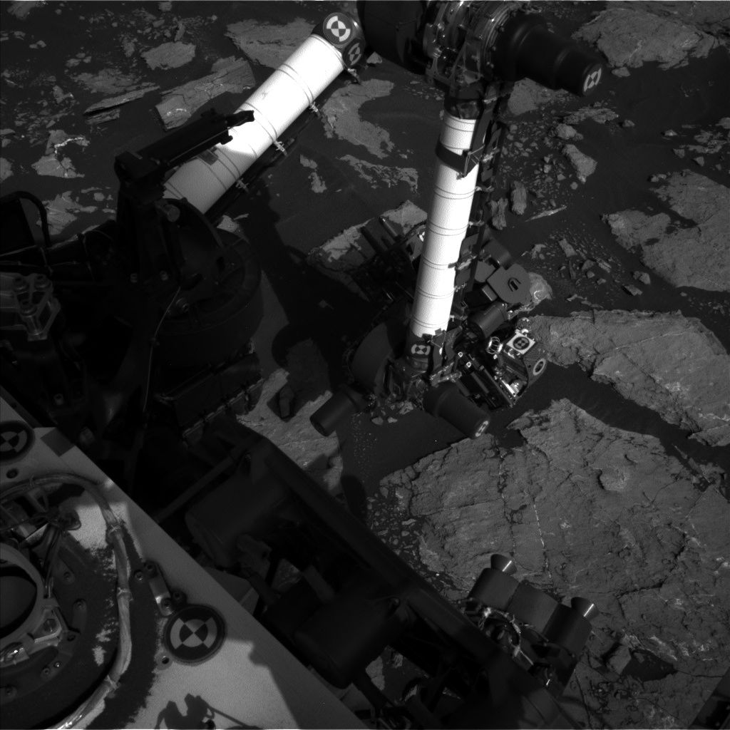
That plan for Sol 1572 includes use of the Mars Hand Lens Imager (MAHLI) to take images of the Rover Environmental Monitoring Station (REMS) booms to diagnose recent problems with the rover’s wind sensors.

Self-inspection of wind sensor booms. Curiosity took this Mars Hand Lens Imager (MAHLI) image on Sol 1572, January 7, 2017.
MAHLI is located on the turret at the end of the rover’s robotic arm.
Credit: NASA/JPL-Caltech/MSSS
“Some of the wind sensors on one boom have not functioned since landing, and sensors on the other boom have been acting up lately,” Herkenhoff notes. Later on the schedule is for MAHLI imagery to be taken of a yellow/red color boundary at “Greenstone” and a full suite of images of a yellow bedrock target named “Isle Au Haut.”
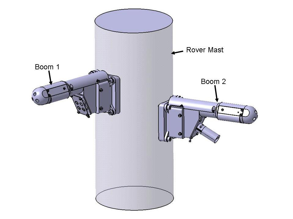
Two small booms on the rover mast record the horizontal and vertical components of wind speed to characterize air flow near the Martian surface from breezes, dust devils, and dust storms.
Credit: NASA/JPL-Caltech/INTA (Instituto Nacional de Tecnica Aeroespacial)
The Alpha Particle X-Ray Spectrometer (APXS) device is then to be placed on Isle Au Haut for an overnight integration.
Dust measurements
Early on the morning of Sol 1573, the scripted plan is to use the rover’s Navcam to search for clouds and Mastcam is to measure the amount of dust in the air by imaging the Sun and the distant crater rim.
“These dust measurements will be repeated at two other times of day later that sol,” Herkenhoff adds.
Later on that sol morning, the Chemistry & Camera (ChemCam) is slated to acquire passive — no laser — observations of its calibration target.
Drill diagnostics
Then the rover’s robot arm is to tasked again to perform new diagnostic tests of the drill feed mechanism, “to help us understand whether the drill feed stall is more sensitive to rotary-only or percussive drilling,” Herkenhoff reports.
“The test data acquired to date indicate an intermittent problem with the internal brake within the motor that feeds the drill forward and backward relative to the rest of the turret,” he explains. “Fortunately, we are able to do everything except drilling while the investigation continues.”
Curiosity Navcam Left B image taken on Sol 1572, January 7, 2017.
Credit: NASA/JPL-Caltech
The team has decided not to try again to drill at Precipice, and to continue driving up the flank of Aeolis Mons – “Mount Sharp”.
Herkenhoff says that after the drill tests, ChemCam will perform some more calibration activities, and acquire laser-induced breakdown spectroscopy (LIBS) data on Greenstone and a bedrock exposure called “Birch Harbor Mountain.”
On tap following that activity is for the rover’s Right Mastcam to image these targets and bright vein targets dubbed “Tarrantine” and “Flying Mountain.”
Drive ahead
On Sol 1574, ChemCam and the rover’s Right Mastcam are scheduled to observe Isle Au Haut before the rover drives away.

Curiosity Mastcam Left image taken on Sol 1571, January 6, 2017.
Credit: NASA/JPL-Caltech/MSSS
After wheeling away, the Curiosity’s arm will be unstowed and the robot’s Navcam will take a stereo pair of images of the arm workspace to prepare for possible contact science on Sol 1575.
Herkenhoff concludes: “It will be another busy weekend for our intrepid rover!”
As always, planned rover activities are subject to change due to a variety of factors related to the Martian environment, communication relays and rover status.

Curiosity Front Hazcam Left B image taken on Sol 1571, January 6, 2017.
Credit: NASA/JPL-Caltech
The NASA Curiosity Mars rover is now in Sol 1571, with ground controllers ready to drive the robot from its investigation of “Old Soaker.”

Curiosity Navcam Left B image taken on Sol 1571, January 6, 2017.
Credit: NASA/JPL-Caltech
Ken Herkenhoff of the USGS Astrogeology Science Center in Flagstaff, Arizona reports that prior to the drive, the plan calls for Chemistry & Camera (ChemCam) and Right Mastcam observations of darker bedrock patches named “Gilley Field” and “Fresh Meadow” and a dark clast called “North Bubble.”

Curiosity Mars Hand Lens Imager (MAHLI) image acquired on Sol 1570, January 5, 2017. MAHLI is located on the turret at the end of the rover’s robotic arm.
Credit: NASA/JPL-Caltech/MSSS
Dark spherule
The rover’s Mastcam is also slated to acquire a multispectral set of images of a dark spherule dubbed “Greening Island” before the drive, Herkenhoff adds.
“After the drive, the arm will be unstowed to allow Navcam and Left Mastcam to take pictures of the area in front of the rover to aid planning for this weekend,” Herkenhoff notes.

Curiosity Mars Hand Lens Imager (MAHLI) image acquired on Sol 1570, January 4, 2017. MAHLI is located on the turret at the end of the rover’s robotic arm.
Credit: NASA/JPL-Caltech/MSSS
Curiosity’s Navcam is also set to search for dust devils and clouds, “then the rover will sleep overnight and recharge her batteries,” Herkenhoff concludes.

