Archive for the ‘Space News’ Category
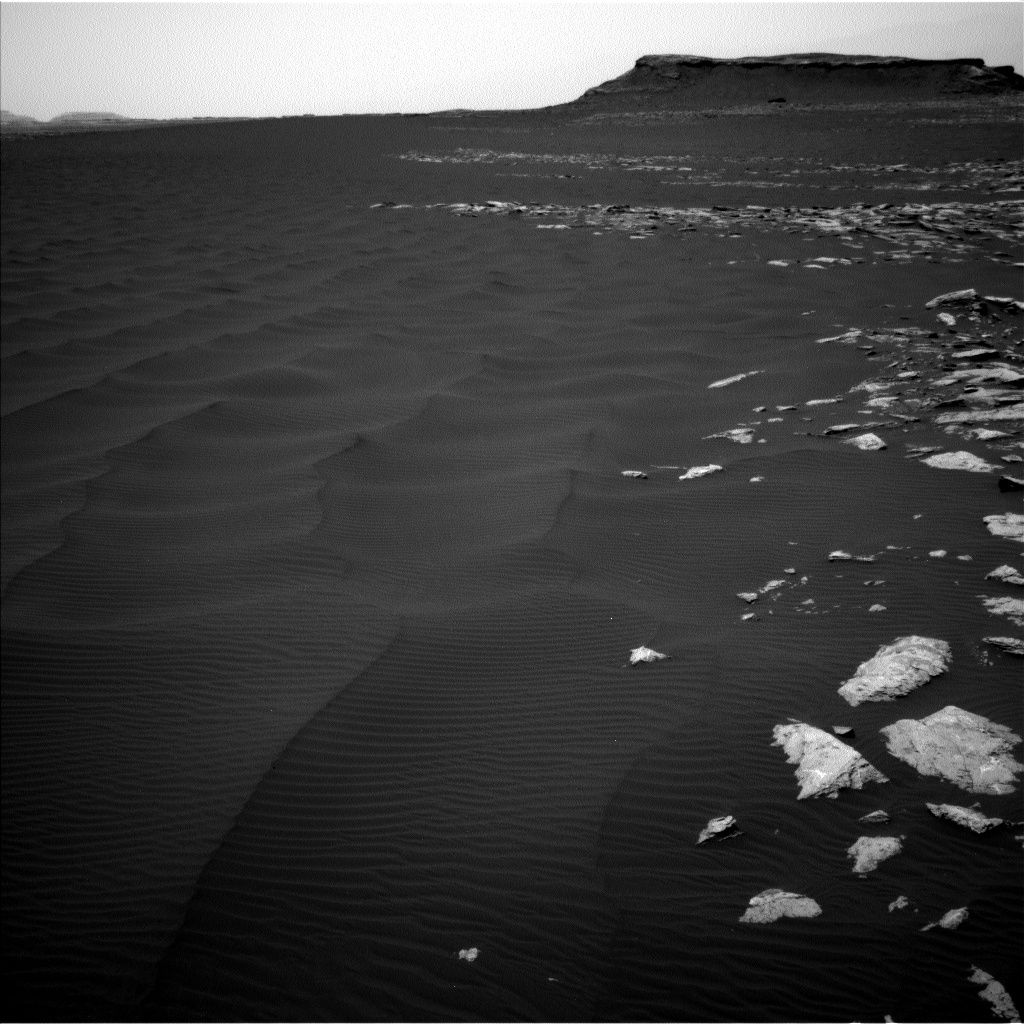
Curiosity Navcam Right B image taken on Sol 1601, February 2, 2016.
Credit: NASA/JPL-Caltech
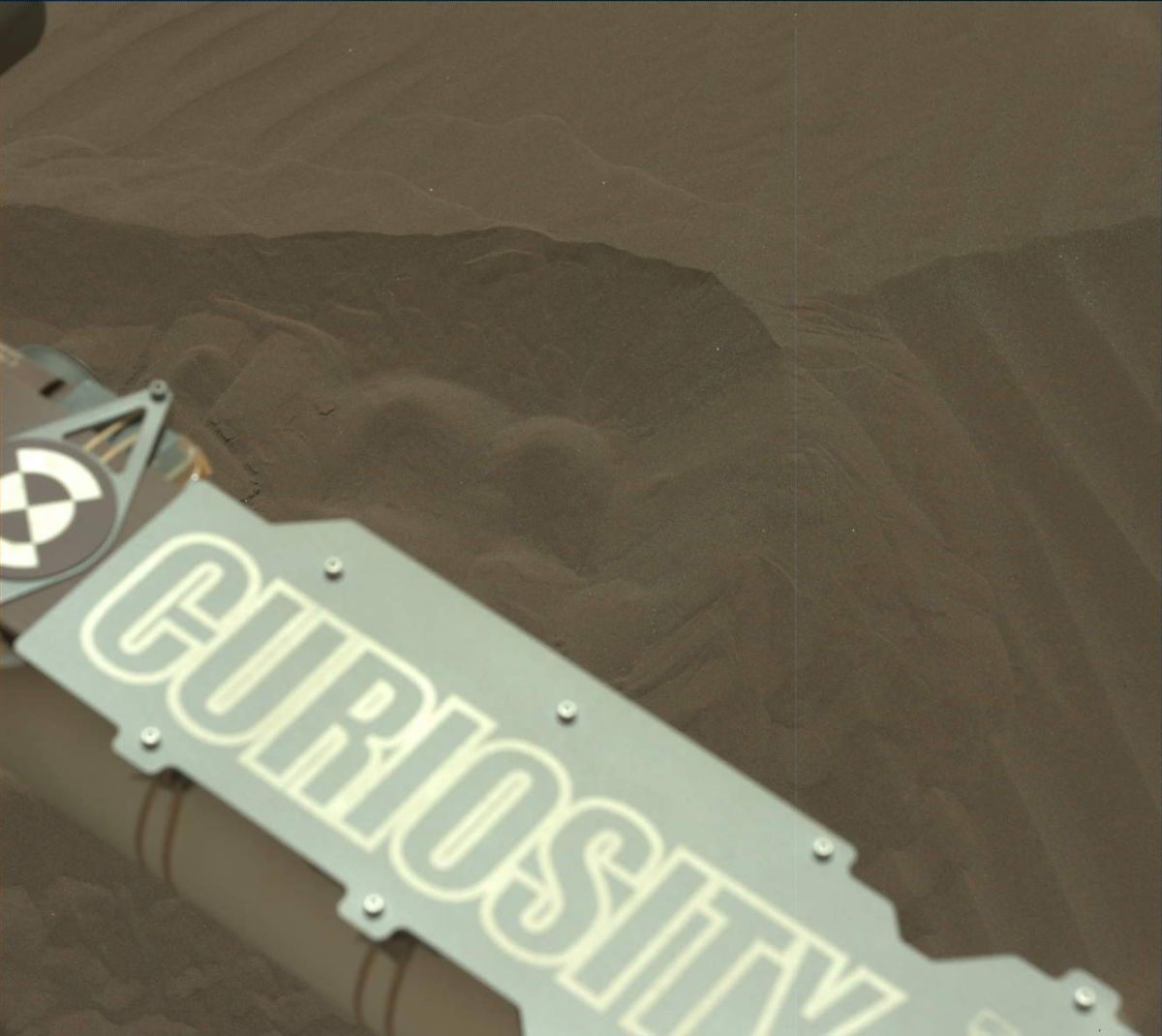
The second half of the Curiosity Mars rover’s campaign to study the “Bagnold Dunes” is well underway.
Now in Sol 1603, the robot is conducting Mastcam mosaics of the dunes, which will be repeated several times to watch for changes, reports Ryan Anderson, a planetary scientist at the USGS Astrogeology Science Center in Flagstaff, Arizona.
Curiosity Mastcam Left image taken on Sol 1601, February 6, 2017.
Credit: NASA/JPL-Caltech/MSSS
Return to active duty
Mastcam is also to do a couple of measurements to determine the amount of dust in the atmosphere. Navcam was to perform a dust devil monitoring observation.
Curiosity’s Chemistry & Camera (ChemCam) was set to do an active laser-induced breakdown spectroscopy (LIBS) observation of the soil target “Mapleton” as the final step in the diagnostics that will allow it to return to active duty.
Curiosity Front Hazcam Left B image taken on Sol 1603, February 8, 2017.
Credit: NASA/JPL-Caltech
Having a field day
In addition to change detection, Anderson notes that the rover’s Mastcam has a stereo image of some bedforms at “Flume Ridge,” a 9×2 mosaic of the interesting nearby dune field, and a 3×2 observation in support of the campaign to watch for dust devils.

Curiosity Mars Hand Lens Imager (MAHLI) image taken on February 7, 2017, Sol 1602.
Credit: NASA/JPL-Caltech/MSSS
Mars Hand Lens Imager (MAHLI) is having a field day, observing the targets “Scarboro”, “McKenny”, “Matagamon”, “Flume Ridge”, “The Forks”, and “West Branch”.
Sol 1602 duties also included repeating the Mastcam change detection observations, going all the way into the evening hours on Mars.
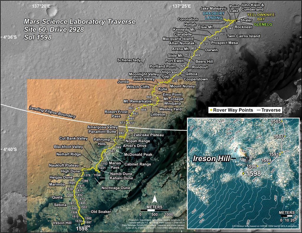
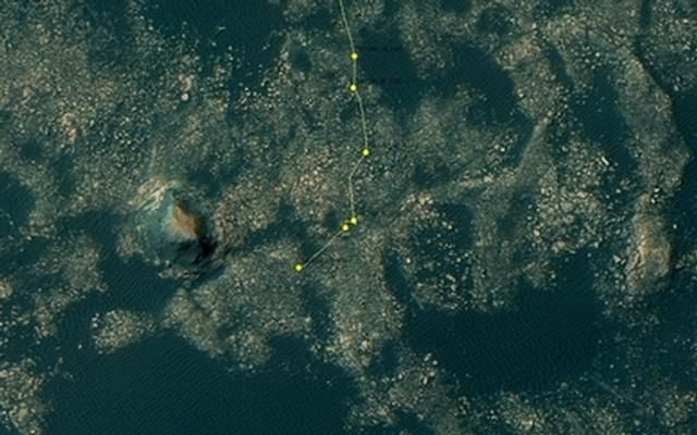
This map shows the route driven by NASA’s Mars rover Curiosity through the 1598 Martian day, or sol, of the rover’s mission on Mars (February 03, 2017). Total odometry for the mission at this point was 9.58 miles (15.42 kilometers). The base image from the map is from the High Resolution Imaging Science Experiment Camera (HiRISE) in NASA’s Mars Reconnaissance Orbiter.
Credit: NASA/JPL-CALTECH/UNIV. OF ARIZONA

Still beaming after all these years – NASA’s Opportunity Mars rover.
Credit: NASA/JPL
Being the veteran Mars explorer it is, the Opportunity rover is wheeling toward a milestone-making investigation – inspecting a Martian gully up-close.
Opportunity is less than a mile from the first Martian gully visited by a spacecraft from Earth. It will investigate the gully for evidence of water or dry sediment flow.
In research to be presented at the 48th Lunar and Planetary Science Conference (LPSC) in March, JPL Mars investigators, Tim Parker and Matt Golombek and colleagues detail what’s perplexing about Martian gullies and their debatable origin.
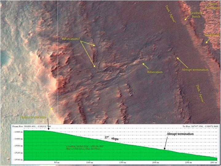
HiRISE map view of gully feature indicating source at Endeavour rim crest.
Credit: Parker, Golombek, et al.;Univ. of Arizona
Gully guessing
Do gullies indicate water flow? Debris flows? Brines?
If fluvial — produced by the action of a river or stream – do they derive from local springs, or small lakes or by precipitation?
Could they be formed by dry avalanches of fine, dry sediment that doesn’t require unusual, wet conditions?
Planetary soldier
Opportunity has been one busy planetary solider since it landed in Meridiani Planum on January 25, 2004 – now over 12 years ago. A dozen Earth years after its air-bag-cushioned touch down on the Red Planet, the rover is enduring its seventh Martian winter.
The gully feature that the robot is headed for was first identified in high resolution imaging science experiment (HiRISE) photos, a super-zoom camera system aboard NASA’s Mars Reconnaissance Orbiter. It was spotted by HiRISE images taken of the west rim of Endeavour crater in 2009, prior to Opportunity’s arrival at Cape York.
Recent image from Opportunity’s Navigation Camera on Sol 4633. As of Sol 4630 (Jan. 31, 2017), the rover’s total odometry is 27.30 miles (43.94 kilometers).
CREDIT: NASA/JPL-CALTECH/CORNELL
The gully has multiple branches that merge and split and appears to cut across the crest of the rim of Endeavour crater, although a bright narrow ridge may be at the gully head. The HiRISE topography shows the gully is on a 17 degree slope.
Useful observations
According to the LPSC research paper led by Parker and Golombek, the fact that the source of the gully is at the crest of the crater rim “may indicate spillover from a small lake to the west of the rim, and rapid draining through the channel into the crater interior.”
Alternatively, they also note that the gully head may have progressively retreated upslope, cannibalizing its own source area. Or a steeper source area at the crater rim may have been eroded away by eolian – wind — abrasion.
Once on location, the Opportunity rover can make a number of useful observations – be it Navcam stereo panoramas and Pancam color stereo shots — to address the origin of the gully.
How far to go?
Just how far is the rover from the gully?
In an email response to Inside Outer Space from Ray Arvidson of Washington University in Saint Louis, deputy principal investigator of the rover mission, it’s roughly 2,296 feet (700 meters) “as the crow flies,” maybe roughly 328 feet (100 meters) more “as Opportunity winds its way south along the Meridiani plains,” Arvidson said.
“Hope to get there within a few months to be able to explore the gully before winter sets in and mobility becomes limited,” Arvidson said.
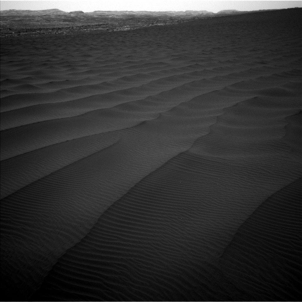
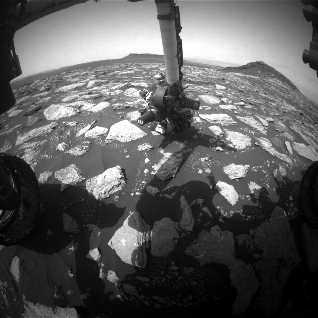
Curiosity Navcam Left B image taken on Sol 1601, February 6, 2017.
Credit: NASA/JPL-Caltech
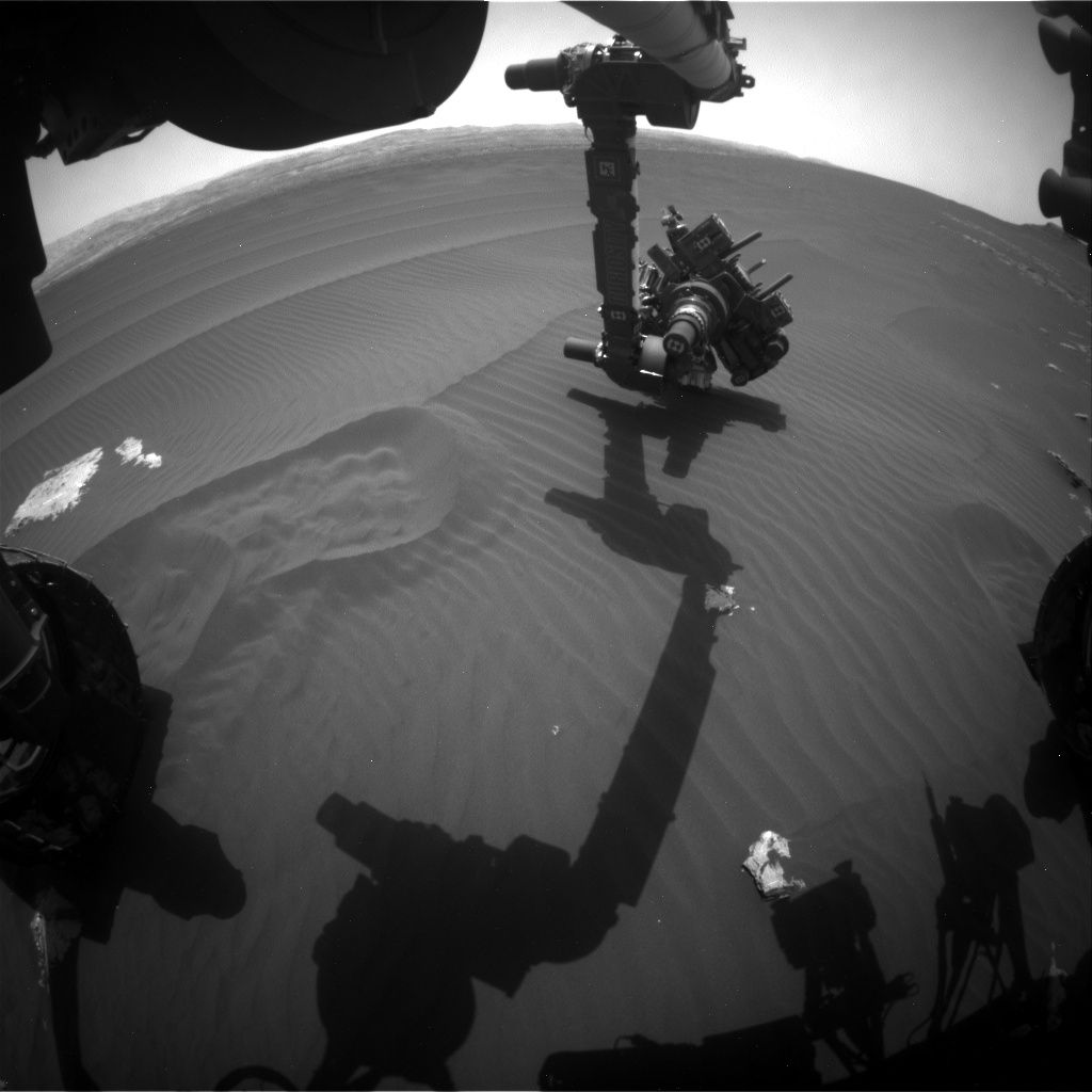
NASA’s Curiosity Mars rover is in position to scan a next segment of the Bagnold Dunes.

NASA’s Mars rover Curiosity Front Hazcam Right B image taken on Sol 1601, February 6, 2017.
Credit: NASA/JPL-Caltech
Last year, the robot made the first up-close study of active sand dunes anywhere other than Earth, at the Bagnold Dunes on the northwestern flank of Mars’ Mount Sharp.
As reported in 2016, some of the wind-sculpted sand ripples on Mars are a type not seen on Earth, and their relationship to the thin Martian atmosphere today provides new clues about the atmosphere’s history.
Curiosity Navcam Left B image taken on Sol 1601, February 6, 2017.
Credit: NASA/JPL-Caltech
Now working in Sol 1601 and entering Sol 1602, the rover was in position to take a Mastcam 360-degree mosaic. This scenic site looks out over the dunes and captures features like “Ireson Hill.”

Curiosity Navcam Right B image of “Ireson Hill” taken on Sol 1601, February 6, 2017.
Credit: NASA/JPL-Caltech

Wake-up call: The 2013 incoming space rock over Chelyabinsk, Russia.
Credit: Alex AlishevskikhNew work in planetary defense not only shows how hard it is to knock out an asteroid with Earth’s name on it…but also what happens if such an object hits our planet.New work in Planetary Defense not only shows how hard it is to knock out an asteroid with Earth’s name on it…but also what happens if such an object hits our planet.
New work in planetary defense not only shows how hard it is to knock out an asteroid with Earth’s name on it…but also what happens if such an object hits our planet.
Back in February 2013, an asteroid with a diameter of roughly 60 feet (18 meters) detonated over the Russian town of Chelyabinsk. That unexpected sky show caused ground injuries and material damage to buildings.
Looking over the leftovers, the Chelyabinsk meteorite was found to be a highly shocked, low porosity, ordinary chondrite, probably similar to S- or Q-type asteroids.

Global worry: Near-Earth Objects (NEOs).
Credit: Texas A&M
International project
Thanks to an international project, led by Spain’s National Research Council, (CSIC), a dedicated effort has focused on how an asteroid might be deflected so as not to collide with the Earth.
Recent research published in The Astrophysical Journal yields information about the local mechanical properties of the minerals forming this meteorite. Those tests are also useful to understand the potential to deflect threatening asteroids using a kinetic projectile.
“Studying the chemical and mineralogical composition of the Chelyabinsk meteorite allows us to grasp the importance of the collision compaction processes that asteroids suffer as they near the Earth,” says CSIC researcher Josep Trigo-Rodríguez of the Institute of Space Sciences in Barcelona, Spain.
“The results of this work are extremely relevant for a possible mission in which we want to efficiently deflect an asteroid which is close to Earth,” Rodriguez adds.
Component materials
Ordinary chondrites, say CSIC researchers, represent the most potentially dangerous asteroids in terms of component materials. Potentially hazardous asteroids that threaten the Earth suffer many collisions before reaching our planet; therefore, their consistency increases and their minerals appear battered.
CSIC experiments used an instrument known as a nanoindentor – a small piston tipped with a diamond head that applies a predefined pressure on the material and generates small notches in it, while measuring both the depth achieved and the material’s elastic recovery time.
Numbers of studies have prompted planetary defense concepts.
Credit: NRC
Those tests made it possible to determine key parameters such as fracture strength, hardness, elastic recovery time of the targeted material. All these could be determinants for the success of a kinetic projectile trying to adjust an asteroid’s orbit from an impending smack-down with Earth.
The CSIC work is reported in “Nanoindenting the Chelyabinsk meteorite to learn about impact effects in asteroids,” The Astrophysical Journal (2017) (DOI:10.3847/1538-4357/835/2/157).
Go to:
https://arxiv.org/abs/1612.07131
Also, go to: Assessment and Mitigation of Asteroid Impact Hazards: Proceedings of the 2015 Barcelona Asteroid Day by Trigo-Rodriguez, Josep Maria, Gritsevich, Maria, Palme, Herbert (Eds.)
This volume outlines the latest advances in asteroid research, particularly on the potential impact hazards.
Go to:
http://www.springer.com/gp/book/9783319461786
Splash down!
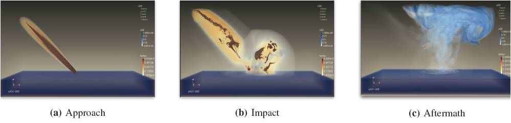
Meanwhile, scientists from Los Alamos National Laboratory (LANL) and the University of Texas, Austin have been using high performance computing to investigate how an asteroid’s kinetic energy is transferred to the atmosphere and Earth’s ocean.
Given that Earth is largely covered by water, an asteroid splashing down in one of Earth’s oceans could inject billions of tons of water into the atmosphere. But the risk of a catastrophic tsunami is reportedly relatively small.
LANL won the Best Visualizaiton and Data Analytics Showcase award at Supercomputing 2016 for their video detailing the science and high performance computing behind the study of asteroid impacts in the ocean.

NASA’s Lindley Johnson is head of NASA’s Planetary Defense Coordination Office.
Credit: Leonard David
These studies help scientists understand the consequences of asteroid impacts and assist NASA’s Office of Planetary Defense in deciding how to deal with potentially threatening near-Earth objects (NEOs).
Megatons of water
LANL’s visualizations show varying factors, especially the differences in airburst events on the transfer of energy from the asteroid to the water.
They report, in some simulations, this resulted in lofting as much as 250 metric megatons of water into the atmosphere. “Because water vapor is a potent greenhouse gas, this may have a significant impact on climate.”
A 250 meter wide asteroid impacting deep water at 45deg with no airburst. High concentrations of asteroid are shown in reddish tones while water is indicated in blue and temperature in yellow.
Credit: LANL
Furthermore, a surprisingly significant factor is the elevation at which the asteroid explodes.
Some asteroids explode on impact with the water. Others airburst and explode prior to entering the water.
Pressure pulse
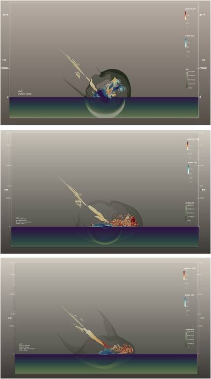
Visualization showing asteroid material (reddish),
water (blue and green), and pressure wave (transparent circle)
for three different simulations in which the height of the
airburst was varied.
Credit: Galen Gisler/LANL
The pressure pulse generated by the airburst propagates in all directions from the source of the explosion. The momentum of the asteroid enhances its downward — generally oblique –impulse, spreading it over a wide area.
In an airburst, pressure pulse is transmitted to the surface of the water by the incoming projectile’s momentum. It is spread over a larger area and displaces less water, so the wave is more coherent as it moves through the water. This produces a wave that travels further.
A surface water explosion causes colliding energy, canceling out the impact on the wave propagation
For their work on this project, Los Alamos’ Data Science at Scale Team won the Best Visualization and Data Analytics Showcase award at Supercomputing 2016 for their video “Visualization and Analysis of Threats from Asteroid Ocean Impacts.”
This is the second consecutive year that Los Alamos’ Data Science at Scale Team has won this award.
Watch the award winning 2016 video here at:
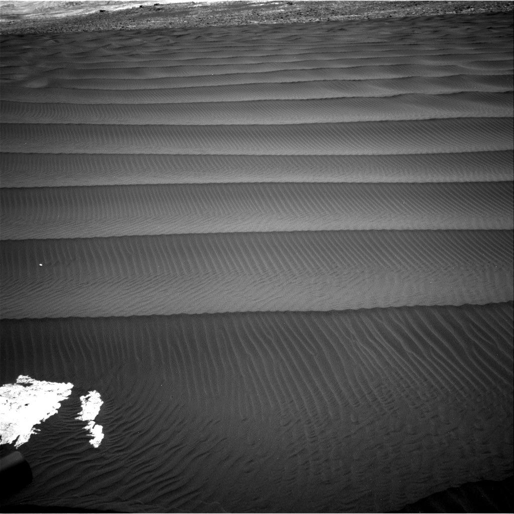
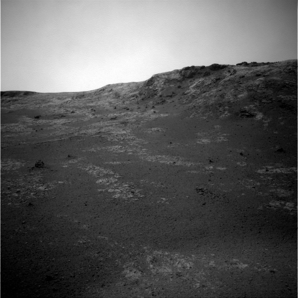
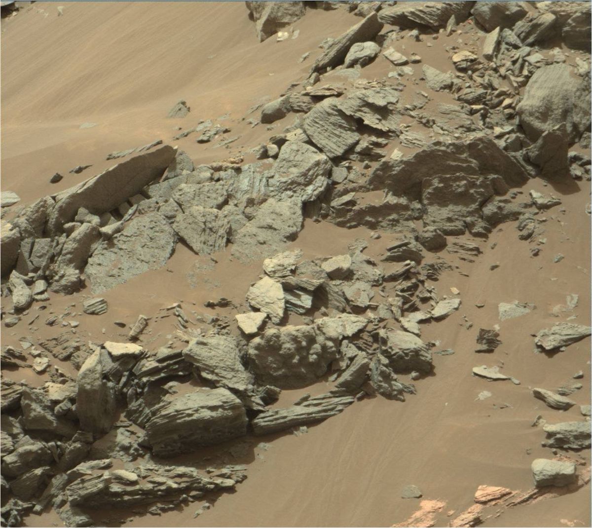
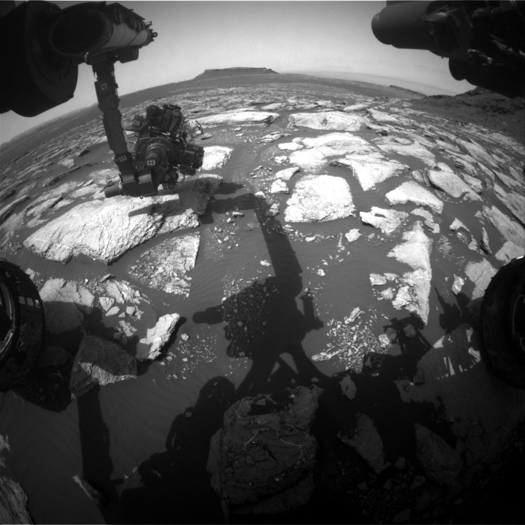
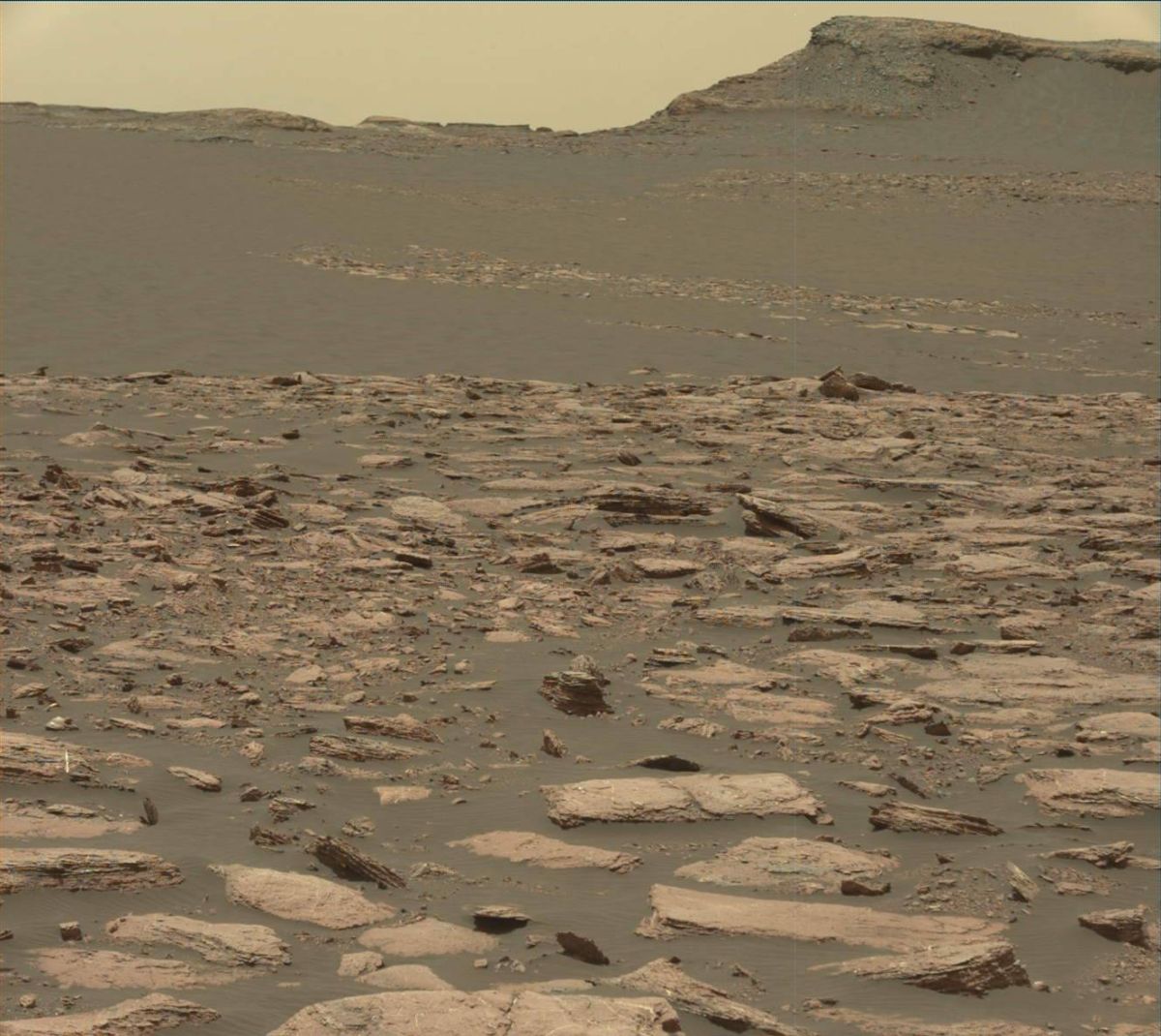
Navcam Right B image from Curiosity of the south side of Ireson Hill, acquired on Sol 1596, February 1, 2017.
Credit: NASA/JPL-Caltech
Now in Sol 1600 on Mars, the Curiosity rover has reached an exciting point in the traverse as the robot approaches the next segment of the Bagnold Dunes.
That’s the word from Lauren Edgar, a research geologist at the USGS Astrogeology Science Center in Flagstaff, Arizona.
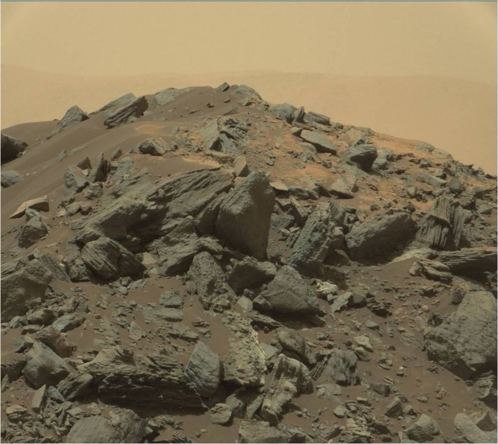
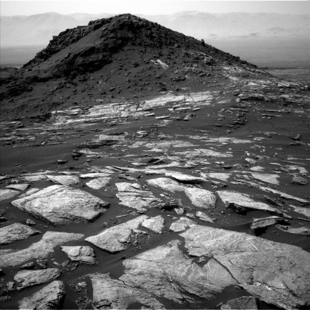
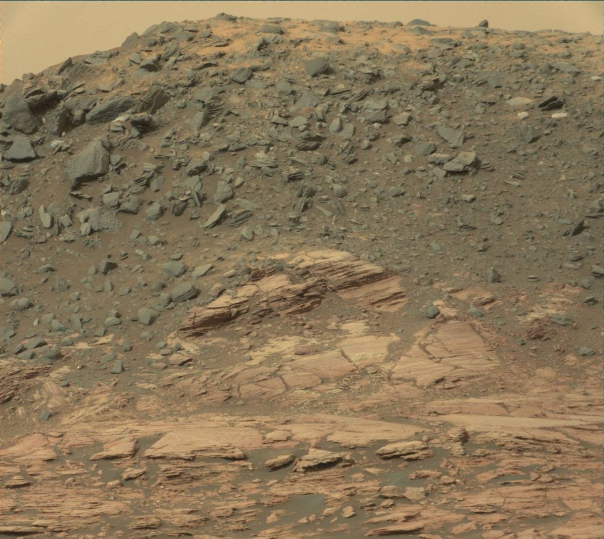
Ireson Hill imagery documents the bedding geometry and cap rock. Curisoity Mastcam Right image taken on Sol 1598, February 3, 2017.
Credit: NASA/JPL-Caltech/MSS
“Curiosity’s weekend plan includes more contact science and driving as we continue to investigate the Murray formation and prepare for observations at the active sand dunes,” Edgar notes.
Bedding geometry
Today, Saturday, is a soliday (a day without planning to allow Earth and Mars schedules to sync back up), Edgar explains, “so we’ll transition from a late slide sol today to early slide sols next week.”
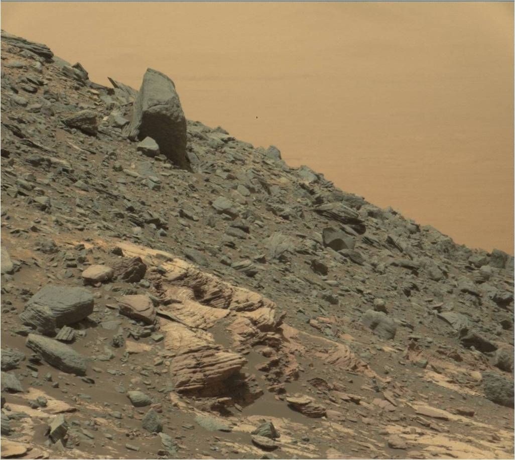
NASA’s Curiosity rover has taken additional and stunning imagery of “Ireson Hill” to document the bedding geometry and cap rock from a different viewing position.
Curisoity Mastcam Right image taken on Sol 1598, February 3, 2017.
Credit: NASA/JPL-Caltech/MSS
On the science schedule is taking a “Mastcam tau.” That’s a way to measure the amount of dust in the atmosphere by imaging the Sun.
Also on tap is making a Navcam dust devil movie, and a Mastcam image to monitor the rover deck.
Stratification and chemistry
Then Curiosity is slated to acquire Mars Hand Lens Imager (MAHLI) images of two targets: “Whiskey” and “Rye.” with a short Alpha Particle X-Ray Spectrometer (APXS) integration on “Whiskey” and a longer overnight integration on “Rye.”
“Both targets were selected to study the stratification and chemistry of the Murray formation here,” Edgar adds.
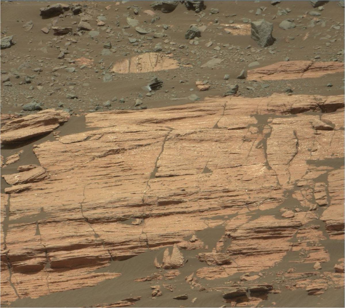
Curisoity Mastcam Right image taken on Sol 1598, February 3, 2017.
Credit: NASA/JPL-Caltech/MSS
Drill diagnostics
On Sol 1601, Curiosity is slated to carry out some drill diagnostics, followed by a drive and post-drive imaging.
“We’ll also take a Mastcam 360-degree mosaic, which should be very scenic from this site – looking out over the dunes and capturing features like “Ireson Hill,” Edgar explains.
Curisoity Mastcam Right image taken on Sol 1598, February 3, 2017.
Credit: NASA/JPL-Caltech/MSS
Lastly, Curiosity will wake up early on Sol 1602 for a suite of environmental monitoring observations.
Edgar concludes: “Stay tuned for the second investigation of the Bagnold Dunes next week!”
Curiosity Navcam Left B image acquired on Sol 1598, February 3, 2017.
Credit: NASA/JPL-Caltech
NASA’s Curiosity Mars rover continued its planetary prowling, driving roughly 70 feet (21 meters) to the southwest back on Sol 1598.
That drive yielded up-close imagery of “Ireson Hill”
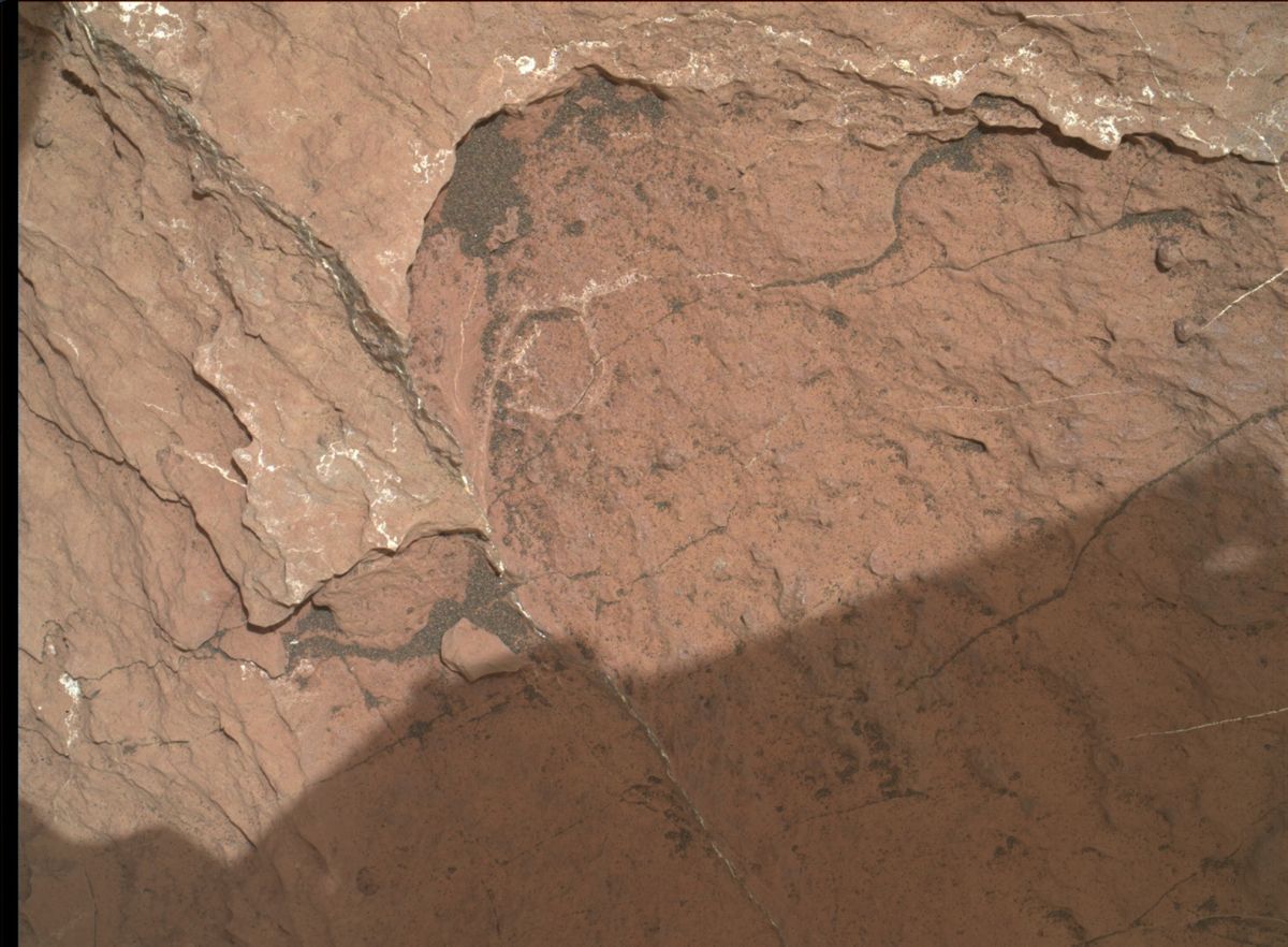
The robot has entered Sol 1599 with scientists implementing a plan that includes Mars Hand Lens Imager (MAHLI) operation and Alpha Particle X-Ray Spectrometer (APXS) of the target “Digdeguah” to investigate typical local bedrock with some exposed stratification.
Navcam Right B image from Curiosity of the south side of Ireson Hill, acquired on Sol 1596, February 1, 2017.
Credit: NASA/JPL-Caltech
Hill imagery
Curiosity’s Chemistry & Camera (ChemCam) is to continue its recovery activities and the rover’s Mastcam is to acquire a large mosaic of Ireson Hill to characterize the contact and color variations exposed on the south side of this feature.
Curiosity Front Hazcam Right B image taken on Sol 1598, February 3, 2017.
Credit: NASA/JPL-Caltech
Fractured features
Lauren Edgar, a research geologist at the USGS Astrogeology Science Center in Flagstaff, Arizona reports that the Curiosity science team also planned a Mastcam mosaic of the “Allsbury” area to document the contact science target and fracture patterns, as well as a Mastcam tau to characterize atmospheric opacity.
Curiosity Mars Hand Lens Imager (MAHLI) photo acquired on Sol 1598, February 3, 2017.
Credit: NASA/JPL-Caltech/MSSS
Drive to southwest
The plan calls for Curiosity to drive further to the southwest, and then take post-drive imaging to prepare for more contact science in the upcoming weekend plan.
Also scheduled, Edgar adds, is environmental monitoring and a Sample Analysis at Mars (SAM) Instrument Suite measurement of the Martian atmosphere.

Credit: SWF
The Secure World Foundation (SWF) has published an impressive handbook, intended to reach two categories of new actors in pioneering the space frontier:
- National governments engaged in developing national space policies and regulations, and
- Start-up companies, universities, and all other non-governmental entities beginning their first forays into space activities.
Changing face of space
In the handbook’s foreword, Michael Simpson, SWF’s Executive Director, points to the changing face of space.
“More than 70 states, commercial companies, and international organizations currently operate more than 1,500 satellites in Earth orbit. Driven largely by the commoditization of space technology and the lowering of barriers to participation, the number of space actors is growing,” Simpson writes. “This broadening of space has both advantages and disadvantages.”

Signing of the Outer Space Treaty. Soviet Ambassador Anatoly F. Dobrynin,
UK Ambassador Sir Patrick Dean, US Ambassador Arthur J. Goldberg, US President
Lyndon B. Johnson and others observe as US Secretary of State Dean Rusk signs the
Outer Space Treaty on January 27, 1967 in Washington, DC
Source: UNOOSA.
Accelerated growth
On one side, Simpson observes, this growth is leading to greatly increased technological innovation, lower costs, and greater access to the beneficial capabilities and services offered by satellites.
“However, the accelerated growth in space activities and the influx of new actors has the potential to exacerbate many of the current threats to the long-term sustainable use of space,” SWF’s Simpson writes. “These threats include on-orbit crowding, radio-frequency interference, and the chances of an incident in space sparking or escalating geopolitical tensions on Earth.”

Statistical representation of the
estimated 500,000 pieces of space debris one centimeter and larger in orbit.
Source: Analytical Graphic
Array of topics
The over 140-page handbook is both succinct and readable, rich in comment on a large number of topics, from space treaties, freedom of exploration and use of space, space traffic management, and orbital debris to use of nuclear power sources in space and protection of celestial bodies.
SWF’s stated intent of the volume is to provide new actors with a broad overview of the fundamental principles, laws, norms, and best practices for peaceful, safe, and responsible activities in space.
To access this highly informative handbook, go to:
https://swfound.org/media/205710/swf_handbook_for_new_actors_in_space_2017_edition.pdf

Book Review: Incredible Stories From Space: A Behind-the-Scenes Look at the Missions Changing Our View of the Cosmos by Nancy Atkinson; Page Street Publishing Co.; 2016; Cost: $19.99
Nancy Atkinson is a veteran space journalist – and this book demonstrates her unique talent in crafting stories regarding robotic exploration – be it unlocking the secrets of faraway Pluto to up-close focus on the Moon via the Lunar Reconnaissance Orbiter.
The book offers behind-the-scene tales of dozens of scientists and engineers who have opened our solar system to discovery and surprising revelation. Spotlighted in this volume, accompanied by beautiful color imagery, are engaging looks at the New Horizons flyby of Pluto, the Curiosity Mars rover, the celestial looks by the Hubble Space Telescope; Kepler, the exo-planet scouting spacecraft; the Cassini-Huygens probing of Saturn; Dawn’s multi-world investigation; the Sun-watching Solar Dynamics Observatory, the Mars Reconnaissance Orbiter, as well as the Lunar Reconnaissance Orbiter.
Each chapter serves up a well-written tale of how this select set of space missions has been transformative in our understanding of our solar system and surrounding universe. “As many space scientists have expressed,” Atkinson points out, “they never know what they’ll find and they’ve learned to expect the unexpected.”
Incredible Stories From Space also includes a look at upcoming missions yet to come, such as the James Webb Space Telescope and a mission to Jupiter’s moon, Europa. The book ends with an excellent epilogue dedicated to the topic of why explore space?
“Looking both outward and inward — and living life with a sense of wonder – can help us create a better world right now and build a better world for future generations,” the author concludes.
For those already familiar with her reporting skillfulness as contributing editor and writer for Universe Today, a popular space and astronomy news website, you’ll find this volume a treasure of insight.
For more information on this book, go to:
http://www.pagestreetpublishing.com/copy-of-101-easy-homemade-products-1
Curiosity Navcam Left B image taken on Sol 1596, February 1, 2017.
Credit: NASA/JPL-Caltech
NASA’s Curiosity rover is now carrying out Sol 1597 duties.
Last weekend, the rover drove roughly 85 feet (26 meters) to the southwest, as scientists prepare for another investigation of active sand dunes.
“We’re still a few more drives away from the dunes, but looking forward to the next campaign,” reports Lauren Edgar, a research geologist at the USGS Astrogeology Science Center in Flagstaff, Arizona.

Curiosity Navcam Right B image taken on Sol 1596, February 1, 2017.
Credit: NASA/JPL-Caltech
Sedimentary structures
In the plans, some contact science and Mastcam imaging and another drive.
That plan starts with a short Alpha Particle X-Ray Spectrometer (APXS)
integration and Mars Hand Lens Imager (MAHLI) photography of “Isleboro” to characterize the composition, grain size, and sedimentary structures exposed in a typical block of the Murray formation.
Then the plan calls for use of the robot’s Mastcam to document some color variations and stratification at “Parker Bog,” and to assess fracture patterns at “Jim Pond.”
Also on the schedule is taking a Mastcam image to monitor the deck and characterize the movement of sand.
“Ireson Hill” as seen in this Curiosity Mastcam image taken on January 25, 2017, Sol 1590.
Credit: NASA/JPL-Caltech/MSSS
Still recovering
The Chemistry & Camera (ChemCam) instrument continues its recovery activities with a laser-induced breakdown spectroscopy (LIBS) observation of the titanium calibration target.
“Then Curiosity will drive further to the southwest,” Edgar adds, and acquire post-drive imaging for context and targeting, including an upper tier Navcam frame to prepare for more imaging of “Ireson Hill.”
Curiosity Front Hazcam Left B image taken on Sol 1596, January 31, 2017.
Credit: NASA/JPL-Caltech
The second sol is devoted to environmental monitoring, with Mastcam and Navcam observations to assess dust in the atmosphere and search for dust devils, Edgar concludes.
Curiosity Mastcam Left image taken on Sol 1594, January 29, 2017.
Credit: NASA/JPL-Caltech/MSSS
Travel distance
From Sol 1591 to Sol 1594, Curiosity had driven a straight line distance of about 84.39 feet (25.72 meters).
Since touching down in Bradbury Landing in August 2012, Curiosity has driven 9.55 miles (15.37 kilometers) as of January 30, 2017.
Curiosity rover’s location for Sol 1594.
The base image of this map is from the High Resolution Imaging Science Experiment Camera (HiRISE) in NASA’s Mars Reconnaissance Orbiter.
Credit: NASA/JPL-CALTECH/University of Arizona

Credit: CCTV-Plus
Along with the booming sound of departing rockets, space tourism is booming in a south China city – at the Wenchang Satellite Launch Center.
The Wenchang launch center is China’s one-of-a-kind coastal launch site. This center will support the country’s space station construction activities in the 2020s, as well as hurling large exploration probes to the Moon – such as the Chang’e-5 lunar sample return mission later this year.
2016 launches
Construction of the site began in Sept 2009 and was completed in Nov 2014. The center has already seen the launch of the Long March-7 last June and the Long March-5 in November 2016.
Wenchang has two vertical assembly and testing plants, two launch towers, a command building and other facilities.
Visitors to the launch complex are shuttled to a launch tower with more areas reportedly opening to the public in the future.
Visitor increase
As reported on CCTV-Plus: “We’re averaging 100 to 200 tourists every day, consisting of locals, who live in Hainan, before November, and tourists who came here in the winter after November,” observed Wang Xiaojia, deputy manager of Wenchang Tourism Investment Holding Co., Ltd.

Credit: CCTV-Plus
The number of tourists in 2016 increased 15 percent year on year since the establishment of Wenchang Satellite Launch Center in 2014, according to the local tourism department.
Tourism town
Construction of a new “tourism town” is underway, reports CCTV-Plus, scheduled to be put into use in the first half of 2017.
In addition to a science and technology exhibit, the town will also use advanced technology — such as visual reality — to enable tourists to experience a realistic rocket launch space exploration missions.
To view a video clip on Wenchang tourism, go to:
http://cd-pv.news.cctvplus.com/2017/0130/8041988_Preview_2751.mp4

