Archive for the ‘Space News’ Category

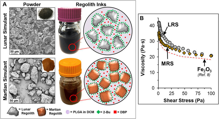
Tools and building blocks made by 3D printing using Moon and Mars simulant.
Credit: Northwestern University
New research demonstrates the ability to use Moon and Mars stimulants to produce 3D-print structures. That ability presents an easy, highly scalable, sustainable manufacturing method for lunar and Red Planet travelers.
3-D printing allows off-planet settlers the wherewithal to make everything from small tools to large buildings using surrounding extraterrestrial resources.
Northwestern Engineering’s Ramille Shah and her Tissue Engineering and Additive Manufacturing (TEAM) Laboratory have demonstrated the ability to 3D-print structures with simulants of Martian and lunar dust.

Credit: Northwestern Engineering/Tissue Engineering and Additive Manufacturing (TEAM) Laboratory
3D-painting
This research draws from earlier work of a “3D-painting process,” a term that Shah and her team use for their novel 3D inks and printing method, utilized to print hyperelastic “bone” as well as 3D grapheme, carbon nanotubes, metals and alloys.
“For places like other planets and moons, where resources are limited, people would need to use what is available on that planet in order to live,” said Shah, assistant professor of materials science and engineering at Northwestern’s McCormick School of Engineering and of surgery in the Feinberg School of Medicine.
“Our 3D paints really open up the ability to print different functional or structural objects to make habitats beyond Earth,” Shah added in a press statement.
Stimulating simulant
The innovative research makes use of NASA-approved lunar and Martian dust stimulants. Those materials mimic in particle shape, and size the dusts found on the Moon and at Mars.
Credit: Northwestern Engineering/Tissue Engineering and Additive Manufacturing (TEAM) Laboratory
Shah’s team created the lunar and Martian 3D paints using the respective dusts, a series of simple solvents, and biopolymer, then 3D printed them with a simple extrusion process. The resulting structures are over 90 percent dust by weight, according to the research team.
The resulting 3D-painted material is flexible, elastic, and tough — similar to rubber.

Credit: Northwestern Engineering/Tissue Engineering and Additive Manufacturing (TEAM) Laboratory
Roll me, fold me, shape me
This is the first example of rubber-like or soft materials resulting from lunar and Martian simulant materials. The material can be cut, rolled, folded, and otherwise shaped after being 3D painted, if desired. In addition, Shah said that Lego-like interlocking bricks can be made by the process.
Partially supported by a gift from Google and performed at Northwestern’s Simpson Querrey Institute, the research was recently published in Nature Scientific Reports.
For that scientific research paper – “Robust and Elastic Lunar and Martian Structures from 3D-Printed Regolith Inks” – go to:

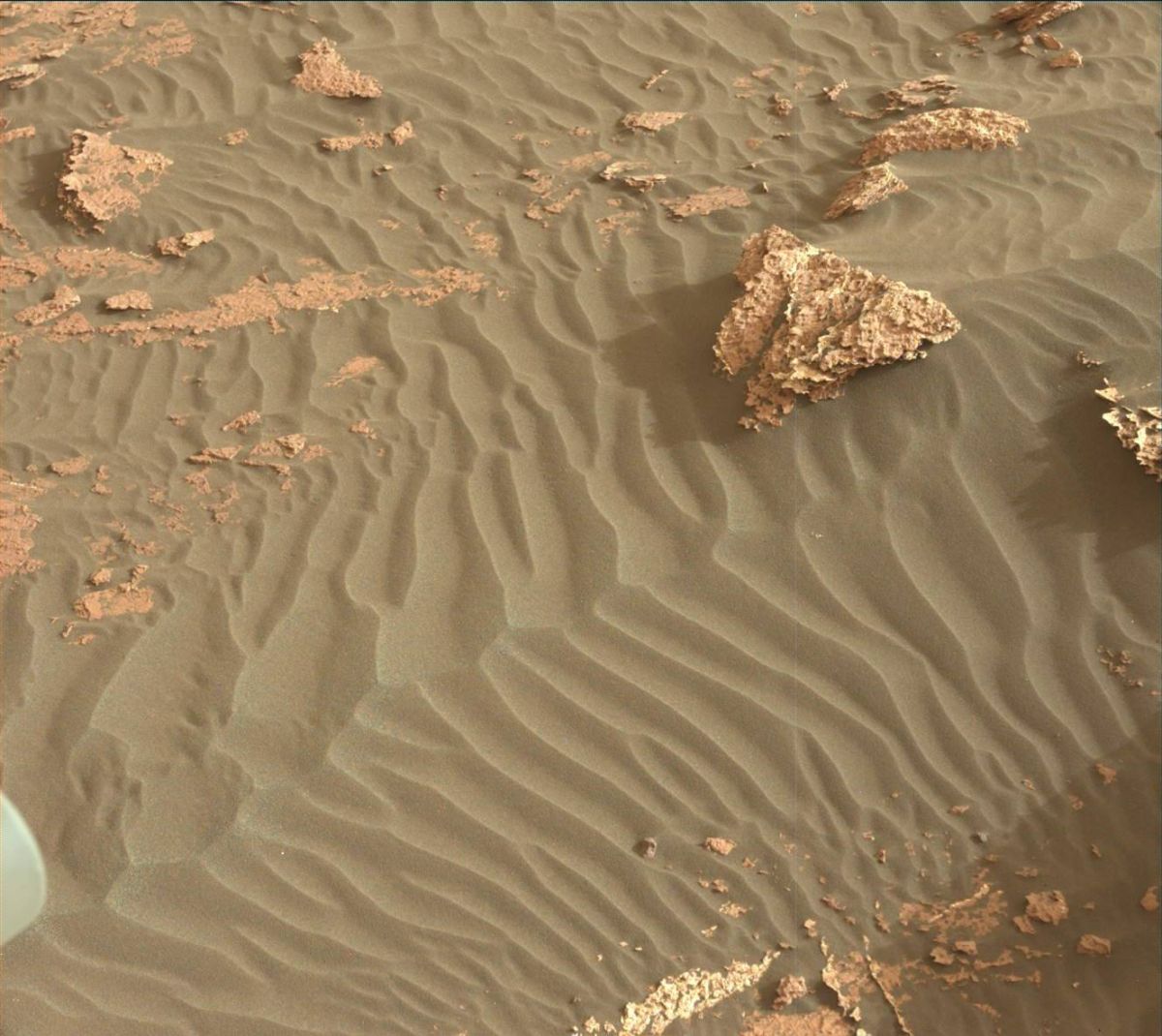
Curiosity Mastcam Right image taken on Sol 1661, April 8, 2017.
Credit: NASA/JPL-Caltech/MSSS
NASA’s Curiosity Mars rover is performing Sol 1663 science duties.
On Sol 1662 the robot drove roughly 79 feet (24 meters) and another drive is planned for Sol 1664.
Targeted remote sensing
“Before the drive, lots of targeted remote sensing is planned,” reports Ken Herkenhoff of the USGS Astrogeology Science Center in Flagstaff, Arizona.

Curiosity Mastcam Right image taken on Sol 1661, April 8, 2017.
Credit: NASA/JPL-Caltech/MSSS
That plan calls for the rover’s Chemistry & Camera (ChemCam) and Right Mastcam to observe a bright rock named “Peaks Island,” an exposure of bedding dubbed “Great Wass Island,” a sand ripple called “Baldpate Mountain,” and an interesting rock that was selected by Autonomous Exploration for Gathering Increased Science (AEGIS) software after the Sol 1662 drive, now named “Chebeague Island.”
Mosaic of outcrops
Curiosity’s Mastcam is scheduled to acquire a stereo mosaic of outcrops toward the south, in the direction of the planned drive, Herkenhoff adds.
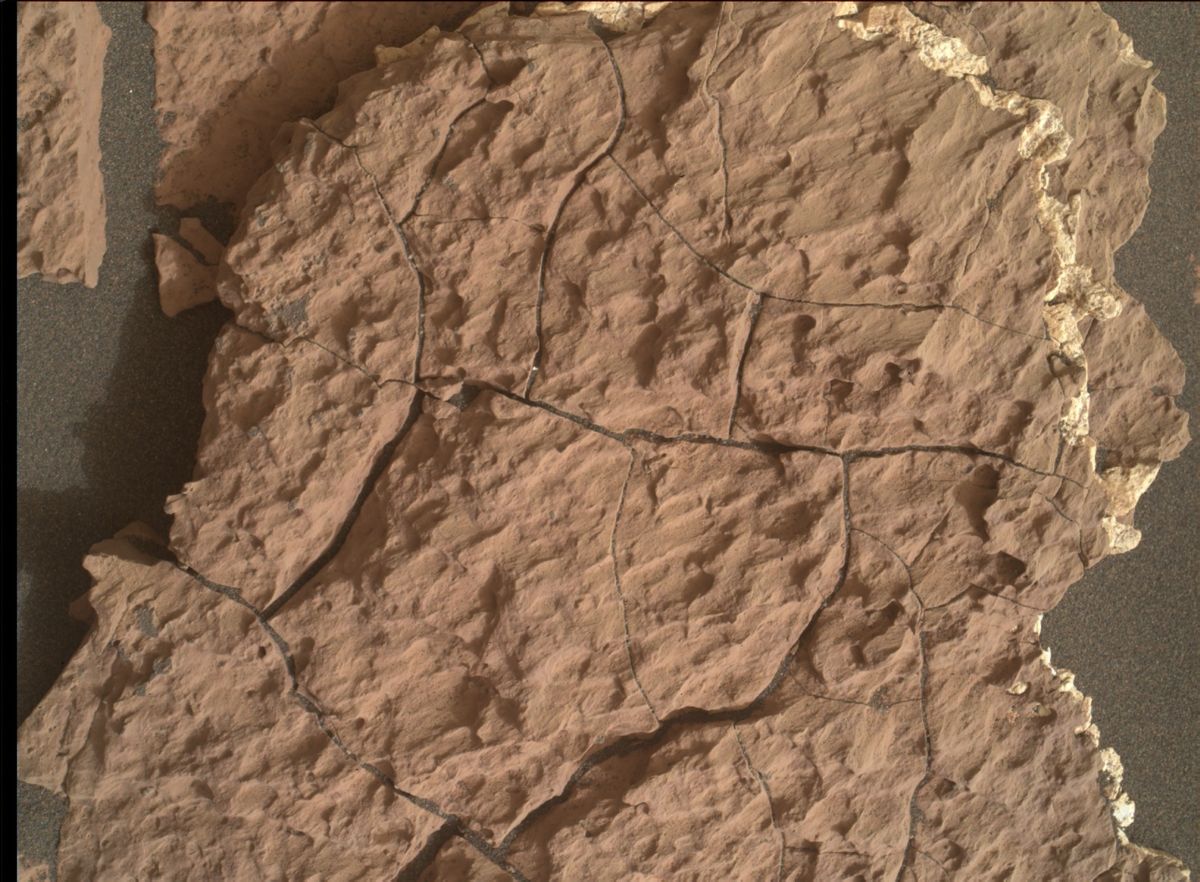
Photo taken by Curiosity’s Mars Hand Lens Imager (MAHLI), located on the turret at the end of the rover’s robotic arm. Sol 1661, April 8, 2017.
Credit: NASA/JPL-Caltech/MSSS
Untargeted remote sensing planned for Sol 1665 includes passive (no laser) ChemCam sky observations and two ground LIBS (Laser Induced Breakdown Spectroscopy) targets selected using the AEGIS software.

Curiosity Mastcam Right image taken on Sol 1661, April 8, 2017.
Credit: NASA/JPL-Caltech/MSSS
Curiosity’s Navcam is slated to then search for dust devils and clouds before the rover rests in preparation for Wednesday’s plan, Herkenhoff concludes.

Pluto nearly fills the frame in this image from the New Horizon’s Long Range Reconnaissance Imager (LORRI).
Credit: NASA/APL/SwRI
The NASA Innovative Advanced Concepts (NIAC) Program nurtures visionary ideas that could transform future NASA missions with the creation of breakthroughs.
Among a new slate of NIAC 2017 Phase I awards is a “Pluto Hop, Skip, and Jump” concept.
The idea has been proposed by Benjamin Goldman of Global Aerospace Corporation in Irwindale, California.
Low fuel load
According to Goldman, imagine a craft that could enter Pluto’s atmosphere and deliver a lander to the surface using aerodynamic drag and just a few kilograms of propellant.

Credits: Benjamin Goldman
Pluto’s surface pressure is just 10 millionths of Earth’s, but its atmosphere is about seven times higher than Earth’s and its volume is about 350 times the volume of Pluto itself.
Over a several hundred kilometer entry distance, this ultra-low ballistic coefficient craft can dissipate over 99.999% of its initial kinetic energy, resulting in a terminal velocity comparable to or less than past planetary landers or rovers.
With this architecture, the total propellant requirement for landing on Pluto is less than 8 pounds (3.5 kilograms).
Surface science
“After making science measurements at its initial landing site, the lander switches to “hopper” mode,” Goldman reports, “taking advantage of the low gravitational acceleration (0.063 gee) and a modest propellant store to literally hop, skip, and jump around the surface, sometimes kilometers at a time, investigating features of interest.”
The NASA Innovative Advanced Concepts (NIAC) Program nurtures visionary ideas that could transform future NASA missions with the creation of breakthroughs.
Credit: NIAC
Goldman suggests that the proposed concept would enable on-the-spot surface science at Pluto with low overall mass, a reasonable cost, and in a timeframe of about 10-15 years.
Initial definition and analysis
Phase I awards are valued at approximately $125,000, for nine months, to support initial definition and analysis of their concepts. If these basic feasibility studies are successful, awardees can apply for Phase II awards.
For more information on NIAC’s just announced Phase 1 and Phase 2 awards, go to:
https://www.nasa.gov/press-release/nasa-invests-in-22-visionary-exploration-concepts

Long distance look of cliff face of Mt. Sharp. Curiosity ChemCam Remote Micro-Imager photo taken on Sol 1661, April 8, 2017.
Credit: NASA/JPL-Caltech/LANL
NASA’s Curiosity rover is now performing Sol 1662 science duties.
A recent drive by the rover placed it away from the “Ogunquit Beach” sand dune, taking the robot about 115 feet (35 meters) to the southwest.
Curiosity has wheeled into “a good location to continue measuring the composition of the bedrock as we drive up Mt. Sharp,” reports Ryan Anderson, a planetary scientist at the USGS Astrogeology Science Center in Flagstaff, Arizona.
Mt. Sharp imagery
A Sol 1661 plan started out with a Mastcam mosaic of “Old Speck Mountain” and some Navcam cloud detection observations.

Curiosity Navcam Left B image taken on Sol 1661, April 8, 2017.
Credit: NASA/JPL-Caltech
The rover’s Chemistry & Camera (ChemCam) was slated then to analyze the targets “Blueberry Mountain,” “Brewer Mountain,” and “Mud Hole” with Mastcam documentation images for each target.
Also carried out where long distance ChemCam images of a cliff face on Mt. Sharp.
Curiosity ChemCam Remote Micro-Imager photo taken on Sol 1661, April 8, 2017.
Credit: NASA/JPL-Caltech/LANL
Curiosity ChemCam Remote Micro-Imager on Sol 1661 April 8, 2017
Credit: NASA/JPL-Caltech/LANL
Overnight analysis
Once the remote sensing is done, Curiosity’s Mars Hand Lens Imager (MAHLI) was slated to take pictures of the targets “Paradise Hill” and “Treasure Island.”
The rover’s Alpha Particle X-Ray Spectrometer (APXS) was then to analyze both targets, with an overnight analysis of Treasure Island.
Easy day
On Sol 1662, the plan calls for driving again, followed by an autonomously targeted ChemCam observation, and on sol 1663 Curiosity will have “a pretty easy day,” Anderson notes, with some Mastcam atmospheric dust measurements and a Mars Descent Imager (MARDI) image of the ground beneath the rover.
Curiosity Mastcam Left image taken on Sol 1659, April 6, 2017.
Credit: NASA/JPL-Caltech/MSSS
Anderson says that the environmental science group has been working to recover the activities that were lost last weekend because of the Deep Space Network outage, such as the morning imaging suite and 15-frame Navcam dust devil movie, while also continuing the normal cadence of monitoring activities.
Sandy DAN
Earlier in the week, a special Dynamic Albedo of Neutrons (DAN) active measurement was acquired over the sand of “Ogunquit Beach.”
“By turning the rover in place and backing up onto the dune, we placed the field of view of DAN’s active neutron experiment, which is centered between the rear two wheels, right on the dune sand,” Anderson adds. DAN active experiments are performed after each rover position change (usually immediately after a drive), but in this case, the measurement was taken just before the rover departed Ogunquit Beach.
“In a DAN active measurement, neutrons are fired in all directions by the Pulse Neutron Generator, and some neutrons scattered by the soil under the rover return to the DAN detectors. This measurement will allow DAN to compare the amount of hydrogen measured at Namib Dune around sol 1243 to the conditions at Ogunquit Beach,” Anderson concludes.
Dates of planned rover activities are subject to change due to a variety of factors related to the Martian environment, communication relays and rover status.

Credit: Bob Sauls – XP4D/Explore Mars, Inc. (used with permission)
A new report — The Fourth Community Workshop on Achievability and Sustainability of Human Exploration of Mars (AM IV) – is now available.
The report is a product from a December 6-8, 2016 meeting organized by Explore Mars, Inc. and the American Astronautical Society.
Nine “long poles” were assessed in depth before and during the workshop and all were found to be achievable. That is, with sustained and focused investment, they all would be available for deployment within about fifteen years or less.
Been there, done that
Sustainability was judged to be one of those long poles, a critical capability, because it is an essential attribute of Mars exploration that is both enabled by and results in value to the nation.
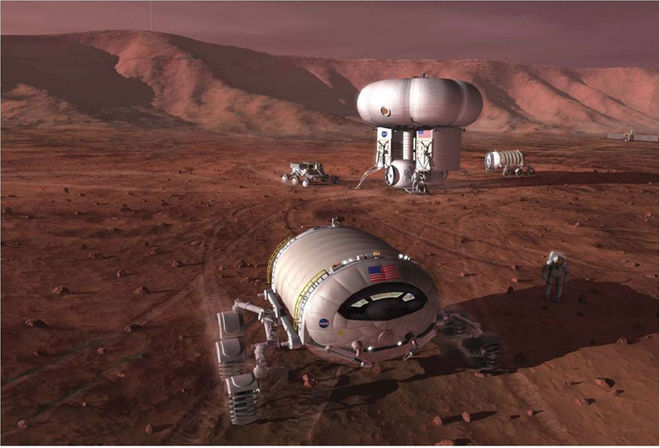
Early pioneering of Mars is expected to provide a gateway for developing the means to sustain a colony of people.
Credit: NASA/Pat Rawlings
The report explains:
“Sustainability will enable Mars exploration to continue after the first several human missions unlike Apollo, which was never designed to be sustainable. It will defeat the “been there, done that” cliché that pervades modern culture and is a threat to sustained Mars exploration and its value to the nation.”
“Sustainability must be deliberately built in to the enterprise design. It will not just happen. It is often confused with affordability. If the enterprise were affordable surely it would be sustainable. Not so. An enterprise that is sustainable is by definition affordable but an enterprise that is affordable is not by definition sustainable.”
This informative report is available at:
https://www.exploremars.org/wp-content/uploads/2017/04/AM-IV-Report-FINAL_2.pdf
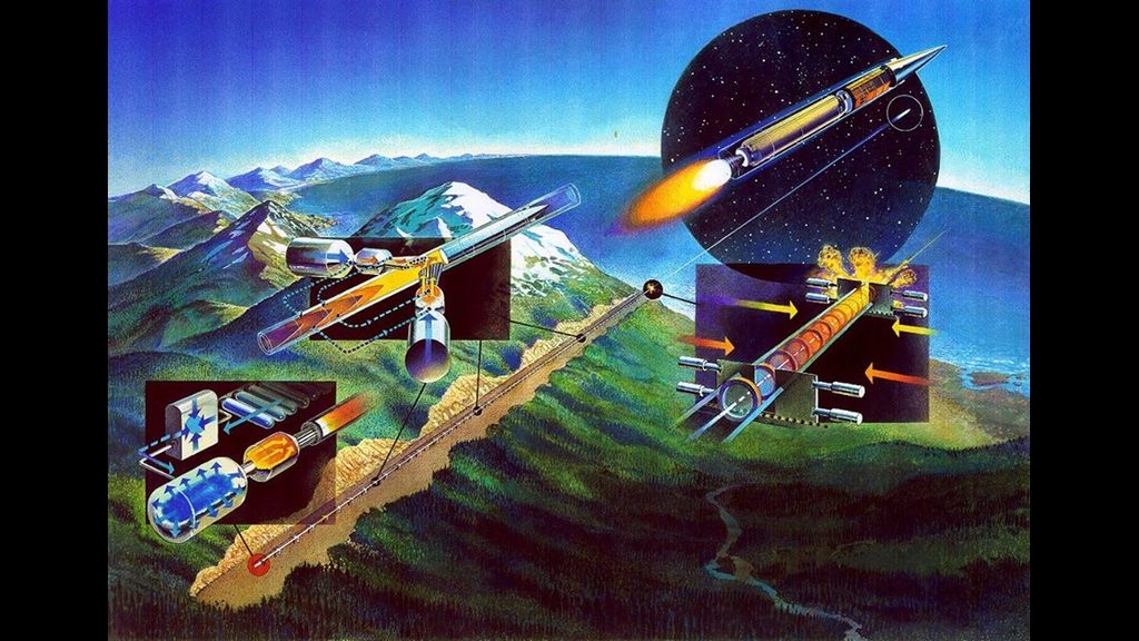
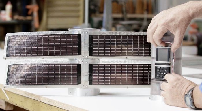
Credit: Green Launch
Thanks to a Kickstarter campaign, a Jules Verneish hydrogen gas gun is being pursued to blast payloads to 62 miles (100 kilometers) altitude — the Karman Line — the boundary between the Earth’s atmosphere and outer space.
The effort is dubbed Green Launch. This Kickstarter is focused on Phase 1: delivery of scientific and DNA payloads to above the Karman Line.
Mini-Mart Deploying Scientific Payloads and DNA Samples.
Credit: Green Launch
Mini-Mart
Green Launch’s delivery vehicle is called Mini-Mart and will be launched by a hydrogen gas gun from the Yuma Proving Ground. The Mini-Mart is so named because it can carry anything as long as it is < 1.25 inches in diameter and 4 inches long. There are three of these cylindrical payloads inside each Mini-Mart vehicle.
At the Karman Line, the Mini-Mart payloads will be ejected and parachute to Earth to be recovered.
Payloads will collect greenhouse gas samples and record atmospheric data as they return to terra firma. In addition, the Mini-Mart will carry postage stamps that have human DNA to beyond the Karman Line. Some payloads will include cameras and electronic sensors.

The Phase 3 orbital launcher is higher performance and will capture and recycle the hydrogen each launch. It is designed to deliver 3U Cubesats to a 300 km Low Earth Orbit.
Credit: Green Launch
Three phase effort
The three step Kickstarter program as blueprinted by the Green Launch team are:
Phase 1: Green Launch of scientific payloads and DNA samples to the Karman Line.
Phase 2: World Record Green Launch to 200 km altitude. Phase 2 is not included in the current Kickstarter unless they receive extra pledges from Phase 1 which may be rolled over into Phase 2.
Phase 3: Green Launch of 3U Cubsats to low Earth orbit. This phase will require more funds at a later date. It will not occur unless they have a successful Phase 1 launch to the Karman Line.
This is a working G-tolerant satellite tested at 3,200 Gs acceleration. It has fully functional solar cells, a camera, power supply GPS and telecommunications.
Credit: Green Launch
Jules Verne redo
Green Launch has its beginnings in the original works by Isaac Newton “Principia Mathematica” and Jules Verne’s 1865 novel, De la terre à la lune (From the Earth to the Moon). It tells the story of the Baltimore Gun Club, a post-American Civil War society of weapons enthusiasts, and their attempts to build an enormous Columbiad space gun to propel three people to the Moon.

From the Earth to the Moon engraving from the 1872 illustrated edition.
Credit: Wikimedia Commons
Thanks to work by scientists at Lawrence Livermore National Laboratory, a working 400 foot long hydrogen gas gun (SHARP) was designed. That work was led by John W. Hunter, now serving as Green Launch’s chief technical officer.
Hydrogen propellant
According to the Green Launch team, the ingredient Jules Verne was lacking is that hydrogen propellant has a very high sound speed compared to solid propellant such as gunpowder.
The available launch velocities demonstrated using hydrogen range as high as 11,200 meters/sec which is Earth escape velocity. Once SHARP was successfully demonstrated in the late 90s, the same scientists took on the task of making space launch more affordable than with expensive and fragile rockets.
As outlined by Green Launch, after completing Phases 1 and 2 at Yuma Proving Ground, using an on-site system, the group plans to use a modified version of SHARP to perform the orbital launches of Phase 3.
Resources
Learn more about this innovative Kickstarter initiative at:
https://www.kickstarter.com/projects/greenlaunch/green-launch-to-the-karman-line?ref=category
Also, go to the Green Launch website at:
BTW: John Hunter is appearing on David Livingston’s The Space Show, Tuesday, April 11, 7-8:30 PM PDT and will discuss the Green Launch project.
To give a listen, go to:

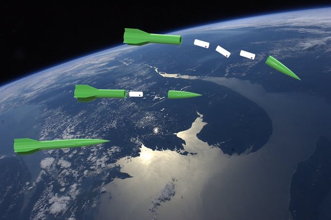
Electromagnetic mass drivers using solar power provide low cost transportation of materials to space construction sites.
Courtesy: Space Studies Institute
Recent testing of an electromagnetic railgun by the U.S. Navy has led to firing a projectile up to Mach 6 – approaching a velocity that harkens back to early ideas of utilizing this technology on the Moon to hurl payloads from the lunar surface.
Mach 6 equals 4,567.24 miles per hour with the escape velocity from the Moon is about 5,300 mph.

Credit: Office of Naval Research
Magnetic fields
The Office of Naval Research work on the EM Railgun launcher is being pursued as a long-range weapon that fires projectiles using electricity instead of chemical propellants.
Magnetic fields created by high electrical currents accelerate a sliding metal conductor, or armature, between two rails to launch projectiles.

Deflection plates near the end of the mass driver make minute adjustments to the trajectory of the launched ore to ensure it reaches its target: a mass catcher at the L-2 point.
Courtesy: Space Studies Institute
Moon-launched payloads
In 1974, Princeton professor and space visionary, the late Gerard O’Neill first proposed use of an electromagnetic rail gun to lob payloads from the Moon.
Mass drivers are based on the coilgun design were adapted to accelerate a non-magnetic object. One application O’Neill proposed for mass drivers: toss baseball-sized chunks of ore mined from the surface of the Moon into space. Once in space, the ore could be used as raw material for building space colonies and solar power satellites.
Mass driver work
O’Neill worked at MIT on mass drivers, working with Henry H. Kolm, and a group of student volunteers to construct their first mass driver prototype. Backed by grants from the Space Studies Institute, later prototypes improved on the mass driver concept, showing that a mass driver only 520 feet (160 meters) long could launch material off the surface of the Moon.

Sparks of creativity. Mass driver workers Gerard O’Neill (center), Henry Kolm (left), Kevin Fine (right).
Electromagnetic thrust
In regards O’Neill’s seminal mass driver work, according to an official at the Office of Naval Research, contacted by Inside Outer Space: “Very interesting proposal to use electromagnetic launchers for space vehicles. Considering the fact that the railgun is working with a small hyper-velocity projectile, and requires significant power and thermal management, I suspect working out the details for movement of larger space vehicles/payloads is a long way off,” the official said. “But I also believe that current efforts will be successful and electromagnetic thrust will eventually be considered for other applications, including space.”
Resources
Check out this video published on March 26, 2017 showing work on the U.S. Navy’s EM Railgun at:
https://www.youtube.com/watch?v=5imlcR0CuJ0
Professor Gerard K. O’Neill founded the Space Studies Institute (SSI) in 1977 with the hope of opening the vast wealth of space to humanity.
For more information on SSI’s on-going work, go to:

Credit: Center for Space Policy & Strategy
Satellites operate in a vacuum; policy makers do not.
The Aerospace Corp.’s Center for Space Policy & Strategy has initiating a White Paper series to address space policy, strategy, and technology topics.
These documents are designed to provide context and points of consideration for important space and technology topics. This library will be expanded and updated on a continuing basis.
A set of White Papers now includes:
1)
National Space Council: History and Potential
Since the dawn of the Space Age, most presidential administrations have had some form of space advisory group. A space council in the Executive Office of the President can be a boon if it works well—aligning policy and strategy across the civil, commercial, and defensive space sectors to serve national interests—or a wasteful exercise if it doesn’t.
http://www.aerospace.org/publications/white-papers/national-space-council-history-and-potential/
2)
Considerations for the Next National Space Policy
Over the past four decades, presidential directives on national space policy, with the intent of providing overarching guidance on civil, commercial, and national security space, have become standard. A new policy directive could simply reiterate many long-held positions—or set new directions and settle unanswered questions.

DSCOVR spacecraft view of the entire sunlit side of Earth from one million miles away, as seen on July 6, 2015.
Credit: NASA
3)
Updating National Policy on Commercial Remote Sensing
The current U.S. commercial remote sensing policy was not designed to accommodate the number, the increasing capabilities, the diverse applications, and the expanding array of global operators of modern remote sensing satellite systems. A revised presidential directive could provide needed guidance on the government’s treatment of satellite imagery and related hardware, software, and value-added services marketed to commercial and foreign entities.
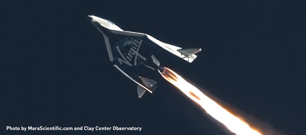
Virgin Galactic’s SpaceShipTwo is shown making a rocket-powered test flight on Jan. 10, 2014.
Credit: MarsScientific.com/Clay Center Observatory
4)
International Commercial Spaceflight Regulation: Assessing the Options
Analysts have begun to address commercial spaceflight regulation, asking questions such as: Does this emerging industry need something akin to the International Civil Aviation Organization? If so, how soon is it needed, what would it look like, and what should be within its jurisdiction?

The crowded space environment may look like this a decade from now, with proposed mega-constellations.
Credit: Center for Space Policy & Strategy
5)
Orbital Debris Remediation through International Engagement
Orbital debris constitutes a serious and growing threat to space operations. As technical barriers to on-orbit cleanup are overcome, political and legal barriers will loom larger. Nonetheless, it is possible to surmount these barriers within the current environment of international treaties and norms.
6)
Orbital Slots for Everyone?
Vast constellations of satellites bring greater risk for collisions and the creation of debris—and no organization is responsible for assessing how they may impact the broader space community. In a future world of mega-constellations, is the unregulated status quo for orbit selection a sustainable path?
http://www.aerospace.org/publications/white-papers/orbital-slots-for-everyone/
For more information on the Center, go to:
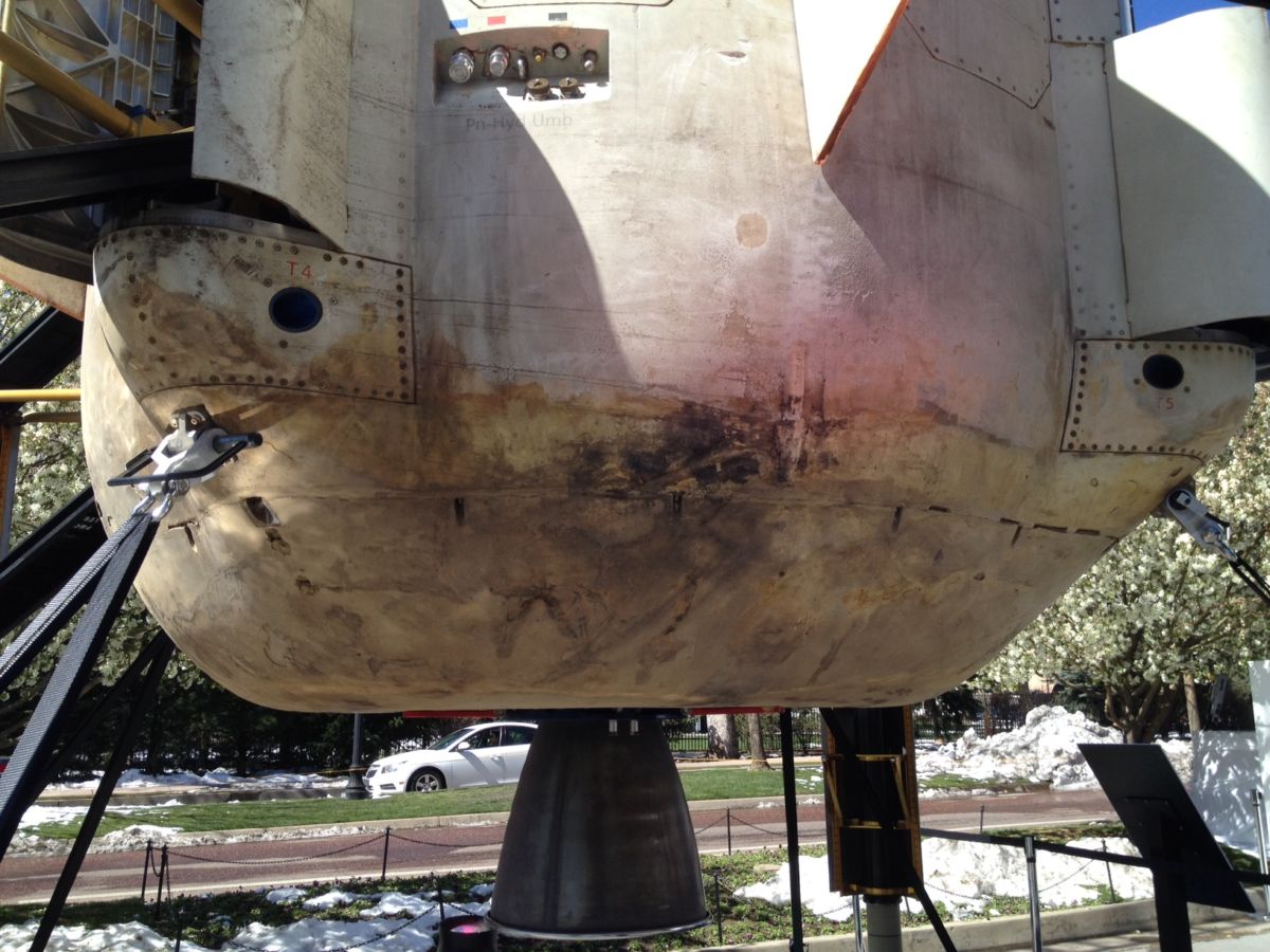
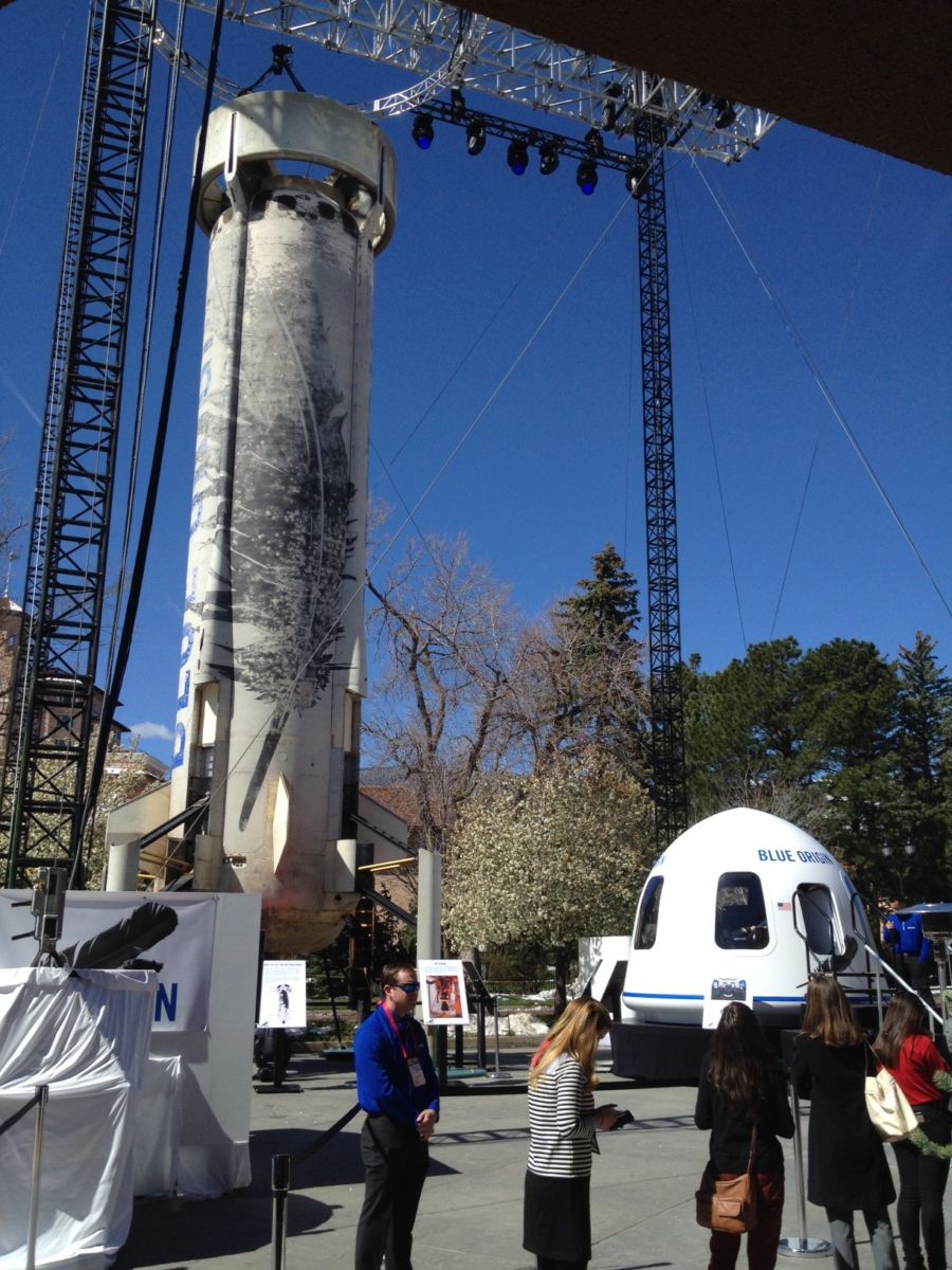
At this week’s grand National Space Symposium in Colorado Springs – the eye-catching Blue Origin New Shepard rocket and passenger capsule was a huge hit.
Here are some images of the display:
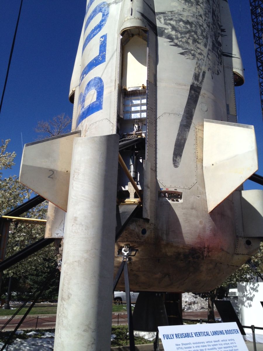
Credit: Leonard David
Credit: Leonard David
Credit: Leonard David

Credit: Leonard David

Credit: Leonard David

Yulong Tian, Secretary-General of the China National Space Administration (CNSA)
Credit: Tom Kimmell
China is pushing forward on a number of space fronts, including milestone making robotic missions to the moon, as well as scoping out an automated Mars return sample mission by 2030.
Yulong Tian, Secretary-General of the China National Space Administration (CNSA), spoke here April 5 during the 33rd Space Symposium.
CNSA is the governmental organization of People’s Republic of China responsible for the management of space activities for civilian use and international space cooperation with other countries.
For my new story on the SpaceNews website, go to:

