Archive for the ‘Space News’ Category

Astro-photographer Marco Langbroek, based in Leiden, the Netherlands, obtained this image of Florence on Saturday evening.
Credit: M. Langbroek
The rocky near-Earth asteroid — 3122 Florence — whizzed by Earth September 1 – coasting by at about 18.4 lunar distances – but there was a surprise.
Radar imagery has revealed that the asteroid has two moons, according to the Jet Propulsion Laboratory’s Center for NEO Studies (CNEOS).
Making use of the 70-meter antenna at the Goldstone Deep Space Communications complex, radar images show two moons orbiting the much larger central body, which is about 2.8 miles (4.5 kilometers) in diameter.
The sizes of the two moons are not yet well known, but are likely between 300-1,000 feet (100 – 300 meters) across.
Future impact concern?
This near-Earth object does not often come so close: the asteroid had last been similarly close in 1930, and will not become close to Earth again until 2057.
According to the European Space Agency, while it usually passes our planet at a safe distance, orbital disturbances in the (distant) future “could bring it closer, and the size of the object is such that it could be of future impact concern.”

Credit: CNEOS/NASA/Jet Propulsion Laboratory via Sky & Telescope magazine
Found to be round
Florence is only the third triple asteroid known in the near-Earth population out of more than 16,400 that have been discovered to date. All three near-Earth asteroid triples have been discovered with radar observations, notes a CNEOS statement.
Florence reached its closest approach to Earth early on September 1 and is now slowly receding from our planet. The asteroid was found to be fairly round. Also, it has a ridge along its equator, at least one large crater, two large flat regions, and numerous other small-scale topographic features.
The images also confirm that Florence rotates once every 2.4 hours.
Additional observations
Additional radar observations are scheduled at NASA’s Goldstone Solar System Radar in California and at the National Science Foundation’s Arecibo Observatory in Puerto Rico through September 8.
These observations should show more surface detail on Florence and provide more precise estimates of the orbital periods of the two moons. Those results are valuable to scientists because they can be used to estimate the total mass and density of the asteroid.

Technicians tend X-37B space plane after tarmac touchdown.
Credit: U.S. Air Force
The enigmatic U.S. Air Force space drone – the X-37B – is heading for a September 7 liftoff, according to military officials.
In an Air Force Space Command statement, the Air Force Rapid Capabilities Office is undergoing final launch preparations for the fifth mission of the X-37B Orbital Test Vehicle (OTV) program.
“The many firsts on this mission make the upcoming OTV launch a milestone for the program,” said Randy Walden, the director of the Air Force Rapid Capabilities Office. “It is our goal to continue advancing the X-37B OTV so it can more fully support the growing space community.”
A program first is that the unpiloted space plane will launch on a SpaceX Falcon 9 launch vehicle. Four previous X-37B missions were all lofted by United Launch Alliance (ULA) Atlas 5 rockets—a joint venture by Lockheed Martin and Boeing. Late last week, the Falcon 9 booster to loft the space plane was static fired.

Last Air Force’s X-37B Orbital Test Vehicle mission touched down at NASA ‘s Kennedy Space Center Shuttle Landing Facility May 7, 2017.
Credit: Michael Martin/USAF
Also, OTV-5 will be launched into, and landed from, a higher inclination orbit than prior missions “to further expand the X-37B’s orbital envelope,” according to the press statement.
Mystery manifest
What this vehicle will carry is largely classified.
However, it is known that the OTV missions are dedicated to advance the X-37B’s performance and flexibility as a space technology demonstrator and host platform for experimental payloads.
“This mission carries small satellite ride shares and will demonstrate greater opportunities for rapid space access and on-orbit testing of emerging space technologies,” the statement adds.
“Building upon the fourth mission and previous collaboration with experiment partners, this mission will host the Air Force Research Laboratory Advanced Structurally Embedded Thermal Spreader [known as ASETS-11] payload to test experimental electronics and oscillating heat pipe technologies in the long duration space environment,” the Space Command statement explains.

The X-37B Orbital Test Vehicle mission 4 (OTV-4), the Air Force’s unmanned, reusable space plane, landed at NASA’s Kennedy Space Center Shuttle Landing Facility May 7, 2017.
Credit: USAF
Long duration record
Flights of the craft have repeatedly broken its own long-duration record.
The first OTV mission began April 22, 2010, and concluded on Dec. 3, 2010, after 224 days in orbit.
The second OTV mission began March 5, 2011, and concluded on June 16, 2012, after 468 days on orbit.
An OTV-3 mission chalked up nearly 675 days in orbit when it landed Oct. 17, 2014.
On May 7, 2017, OTV-4 landed at NASA’s Kennedy Space Center Shuttle Landing Facility – a first for the program as all previous missions ended with a tarmac touchdown at Vandenberg Air Force Base in California. The OTV-4 conducted on-orbit experiments for 718 days during its mission, extending the total number of days spent on-orbit for the OTV program to 2,085 days.
Built by Boeing
Built by Boeing, the robotic mini-space plane is one of two known reusable X-37B vehicles that constitute the space plane “fleet.”
Appearing like a miniature version of NASA’s now-retired space shuttle orbiter, the reusable military space plane is 29 feet (8.8 meters) long and 9.6 feet (2.9 meters) tall, and has a wingspan of nearly 15 feet (4.6 meters).
The space drone has a payload bay about the size of a pickup truck bed that can be outfitted with a robotic arm. It has a launch weight of 11,000 pounds (4,990 kilograms) and is powered on orbit by gallium arsenide solar cells with lithium-ion batteries.

U.S. Rep. Jim Bridenstine
Late Friday, U.S. President Trump announced his intent to nominate U.S. Rep. Jim Bridenstine as the 13th NASA administrator. The Republican lawmaker is from Oklahoma.
The nomination must go through a Senate confirmation process first, as will the deputy administrator nomination when that person is named by the President.
Bridenstine is a former executive director of the Tulsa Air and Space Museum & Planetarium and is author of the American Space Renaissance Act (H.R. 4945).

Earth’s Moon as seen from the International Space Station taken by ESA British astronaut, Tim Peake.
Credit: NASA/ESA
Wanted: American space renaissance
The mission of H.R. 4945 — The American Space Renaissance Act (ASRA) — is to permanently secure the United States as the preeminent spacefaring nation. The ASRA has three key objectives:
- Project military strength and protect our space based capabilities
- Provide certainty to encourage commercial space innovation
- Promote stability, accountability, and mission clarity at NASA
Why the Moon matters
Late last year, Bridenstine wrote a blog post, “Why the Moon Matters,” that can be read here:
https://bridenstine.house.gov/blog/?postid=772
To take a look at H.R.4945 – The American Space Renaissance Act, go to:
https://www.congress.gov/bill/114th-congress/house-bill/4945
Also, go to:

Curiosity Left B image taken on Sol 1803, September 1, 2017.
Credit: NASA/JPL-Caltech
NASA’s Curiosity Mars rover is now in Sol 1804 carrying out multiple scientific duties.
A new rover road map has been issued by the Jet Propulsion Laboratory, showing its traverse over the landscape since landing in August 2012.

Curiosity Front Hazcam Right B image acquired on Sol 1803, September 1, 2017.
Credit: NASA/JPL-Caltech
The map through Sol 1802 shows the route driven by Curiosity.

Credit: NASA/JPL-Caltech/University of Arizona
Numbering of the dots along the line indicate the sol number of each drive. North is up. The scale bar is 1 kilometer (~0.62 mile).
From Sol 1800 to Sol 1802, Curiosity has driven a straight line distance of about 47.03 feet (14.34 meters).
That movement has brought the rover’s total odometry for the mission to 10.76 miles (17.32 kilometers).

Curiosity Mastcam Left photo taken on Sol 1802, August 31, 2017.
Credit: NASA/JPL-Caltech/MSSS
The base image from the map is from the High Resolution Imaging Science Experiment Camera (HiRISE) in NASA’s Mars Reconnaissance Orbiter.

Curiosity Mastcam Left photo taken on Sol 1802, August 31, 2017.
Credit: NASA/JPL-Caltech/MSSS

Credit: Penguin Random House
A heist story set on the Moon – early PR for Andy Weir’s new novel: Artemis.
The bestselling author of The Martian returns with a new near-future thriller.
According to Penguin Random House:
“Jazz Bashara is a criminal. Well, sort of. Life on Artemis, the first and only city on the moon, is tough if you’re not a rich tourist or an eccentric billionaire. So smuggling in the occasional harmless bit of contraband barely counts, right? Not when you’ve got debts to pay and your job as a porter barely covers the rent.”
Everything changes when Jazz sees the chance to commit the perfect crime, with a reward too lucrative to turn down, explains the PR blurb. “But pulling off the impossible is just the start of her problems, as she learns that she’s stepped square into a conspiracy for control of Artemis itself—and that now, her only chance at survival lies in a gambit even riskier than the first.”

New planetary prowler – the NASA Mars 2020 rover – scouring the Red Planet for select samples for eventual return to Earth.
Credit: NASA/JPL
NASA’s next Mars rover is being readied for the Red Planet. To be launched in July/August 2020 and slated for arrival in February 2021, it is the most complex piece of machinery ever plopped down on that distant world.
Once on the planet, the nuclear-powered Mars 2020 rover has unusual duties compared to predecessor robots. To achieve a checklist of jobs it is imbued with far more software smarts to land upon and traverse across Mars while rapidly carrying out an agenda of scientific tasks.
Next gen rover

Once again, stand by for another 7 minutes of terror as the Mars 2020 rover is lowered onto the Red Planet by the Sky Crane.
Credit: NASA/JPL
To learn more on this impressive mission to Mars, go to my new article in the September 2017 issue of Aerospace America – the magazine of the American Institute of Aeronautics and Astronautics (AIAA):
To read “Beating Curiosity: A Next Generation Robotic Rover Could Start Rolling Across the Mars Surface in 2021”
Go to:
https://aerospaceamerica.aiaa.org/features/beating-curiosity/

Credit: SpaceX
The soon-to-launch SpaceX Falcon Heavy is billed by the company as the world’s most powerful operational rocket. Its maiden flight is slated for November, rocketing off pad 39A at the Kennedy Space Center in Florida.
No matter how you look at it – Falcon Heavy is a big deal.
Its first stage is composed of three Falcon 9 nine-engine cores adding up to 27 Merlin engines.

The twenty-seven Merlin engines that power Falcon Heavy’s three cores are arranged in an “Octaweb” structure.
Credit: SpaceX
Excitement guaranteed
“There’s a lot that could go wrong there. I encourage people to come down to the Cape to see the first Falcon Heavy mission. It’s guaranteed to be exciting,” said Elon Musk founder, CEO and lead designer at SpaceX.
“I hope it makes it far enough away from the pad that it doesn’t cause pad damage,” Musk said. “I would consider even that a win to be honest. Yeah…a major pucker factor really is the only way to describe it.”
Cluster busters

Soviet Union’s N-1 Moon rocket – cluster of engines.

Saturn V booster with its cluster of five F-1 engines.
Credit: NASA

Russian Soyuz booster is rolled out to the launch pad by train on Monday, April 17, 2017 at the Baikonur Cosmodrome in Kazakhstan.
Credit: NASA/Aubrey Gemignani
Rocketry’s “Big Bang” theory?
What’s at stake? What’s behind “clusterphobia”?
Check out my new Space.com story at:
‘Major Pucker Factor’: Will SpaceX’s Falcon Heavy Ace Its Maiden Launch?
https://www.space.com/38016-spacex-falcon-heavy-rocket-maiden-launch-success-chances.html

Curiosity Navcam Left B image taken on Sol 1800, August 29, 2017.
Credit: NASA/JPL-Caltech
Now performing Sol 1802 duties, NASA’s Curiosity’s Mars rover drove on Sol 1801 bringing it to an excellent location for contact and remote science as part of a 3-sol plan that sets up the robot for a long Labor Day weekend.
That’s the report from Rachel Kronyak, a planetary geologist from the University of Tennessee in Knoxville.
Murray bedrock
The plan called for kicking off Sol 1802 with contact science, using Curiosity’s Mars Hand Lens Imager (MAHLI) plus the Alpha Particle X-Ray Spectrometer (APXS). The target is called “Tyler” – a region of Murray bedrock just in front of the rover.

Curiosity Mastcam Left image acquired on Sol 1800, August 29, 2017.
Credit: NASA/JPL-Caltech/MSSS
“We’ll then enter into a very full, science-packed remote science block,” Kronyak notes, during which the rover will make Chemistry and Camera laser-induced breakdown spectroscopy (ChemCam LIBS) observation on Tyler and take a number of Mastcam mosaics.
“These mosaics will look at sedimentary structures and layering within the beautifully exposed rocks of the Vera Rubin Ridge in front of us,” Kronyak adds. The mosaics are fairly extensive and will document the targets named “Pettegrove Point,” “Rumills Hub,” “Mink Rocks,” “The Downfall,” and “Popplestone Ledge.”
Stereo mosaics
“Most of the Mastcam observations in the plan are actually stereo mosaics, which means we take each image with both the left and right eyes of Mastcam,” Kronyak explains. “Stereo mosaics are pretty resource intensive, but they provide us with three-dimensional depth information, which is especially useful for making geologic interpretations.”

Curiosity Front Hazcam Left B image taken on Sol 1800, August 29, 2017.
Credit: NASA/JPL-Caltech
Following Curiosity’s heavy science block, the robot will drive and collect standard post-drive images to set up for contact and remote science over the weekend. Also on tap is a post-drive Dynamic Albedo of Neutrons (DAN) and Rover Environmental Monitoring Station (REMS) observations, Kronyak concludes.

Curiosity ChemCam Remote Micro-Imager photo taken on Sol 1800, August 29, 2017.
Credit: NASA/JPL-Caltech/LANL
We’ll also do a post-drive DAN active along with our standard DAN passive and REMS observations.

It’s a big Universe – anybody out there?
Credit: Space Telescope Science Institute
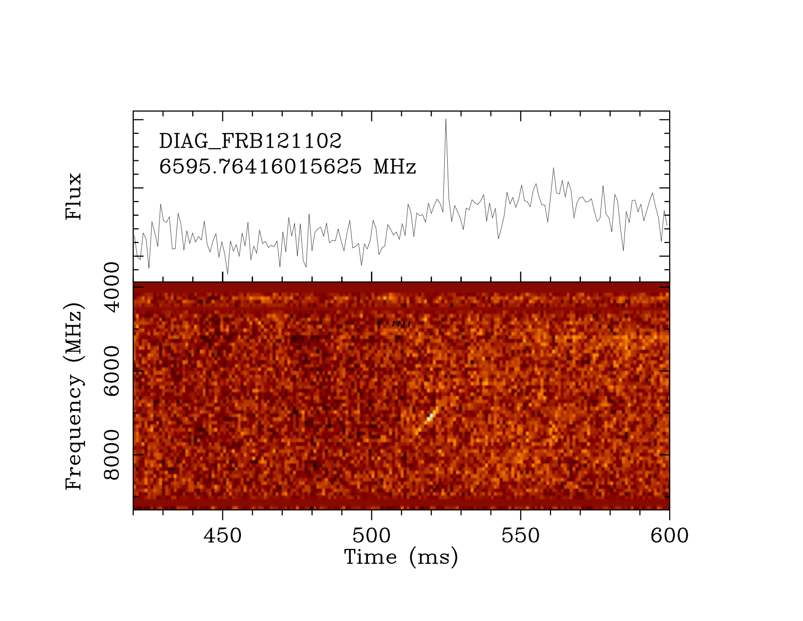
The “Breakthrough Listen” campaign, a project to find signs of intelligent life in the universe, has detected 15 fast radio bursts (FRBs) emanating from the mysterious “repeater” FRB 121102.
Could these brief, bright pulses of radio emission from distant galaxies be signatures of extraterrestrial technology?
Breakthrough Listen is a global astronomical initiative launched in 2015 by Internet investor and philanthropist Yuri Milner and cosmologist Stephen Hawking.

Green Bank Telescope (GBT) telescope, located in West Virginia.
Credit: NSF
Telescope observations
Breakthrough Listen announced today that West Virginia-based Green Bank Telescope observations of a dwarf galaxy three billion light years away reveal 15 bursts of radio emission. This is the first time bursts from this source have been seen at these frequencies.
The Listen science team at UC Berkeley added FRB 121102 to their list of targets. In the early hours of Saturday, August 26, UC Berkeley Postdoctoral Researcher Vishal Gajjar observed the location of FRB 121102 using the Breakthrough Listen digital backend instrument at the Green Bank facility.
New pulses
Analysis by Gajjar and the Listen team revealed 15 new pulses from FRB 121102. As well as confirming that the source is in a newly active state, the high resolution of the data obtained by the Listen instrument will allow measurement of the properties of these mysterious bursts at a higher precision than ever possible before.

Credit: Breakthrough Initiative
The Listen backend, which is able to record several gigahertz of bandwidth at a time, split into billions of individual channels, enable a new view of the frequency spectrum of FRBs, and should shed additional light on the processes giving rise to FRB emission.
Possible explanations
Whether or not FRBs are indeed signatures of extraterrestrial technology remains a TBD, according to Breakthrough Listen.

Credit: Breakthrough Listen
According to a press statement released today: “Possible explanations for FRBs range from outbursts from rotating neutron stars with extremely strong magnetic fields, to more speculative ideas that they are directed energy sources used by extraterrestrial civilizations to power spacecraft.”
Observations may indicate FRB 121102 is currently in a heightened activity state, notes Gajjar “and follow-on observations are encouraged, particularly at higher radio frequencies.”
Resources
The new results are reported as an Astronomer’s Telegram and will be described in further detail in an upcoming scientific journal article.
Go to: http://www.astronomerstelegram.org/?read=10675
Also, go to this Breakthrough Listen-provided linked graphic that shows 14 of the 15 detected bursts in succession, illustrating their dispersed spectrum and extreme variability:
https://storage.googleapis.com/frb121102/FRB121102_Cband_GB.gif
For additional information on the various Breakthrough Initiatives, go to:
http://breakthroughinitiatives.org/

Credit: NASA/JPL-Caltech/University of Arizona

Curiosity Navcam Left B image taken on Sol 1800, August 29, 2017.
Credit: NASA/JPL-Caltech

Curiosity Front Hazcam Right B image taken on Sol 1800, August 29, 2017.
Credit: NASA/JPL-Caltech

Curiosity Navcam Left B image taken on Sol 1800, August 29, 2017.
Credit: NASA/JPL-Caltech

Curiosity Rear Hazcam Right B image acquired on Sol 1800, August 29, 2017.
Credit: NASA/JPL-Caltech

Curiosity Navcam Left B image taken on Sol 1800, August 29, 2017.
Credit: NASA/JPL-Caltech
NASA’s Curiosity rover is in the early hours of performing Sol 1801 duties.
As the robot moves forward to ascend Vera Rubin Ridge, new imagery is helping scientists better understand how the ridge formed.


