Archive for the ‘Space News’ Category

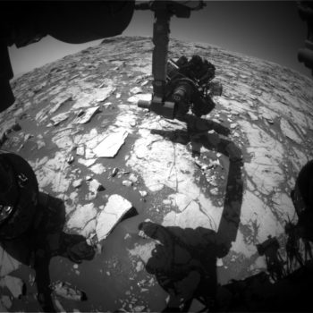
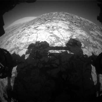
Curiosity Front Hazcam Right B image acquired on Sol 1836, October 5, 2017.
Credit: NASA/JPL-Caltech
Deep into Sol 1836, NASA’s Curiosity Mars rover ran into uplink issues due to a Deep Space Network technical problem.
Reports Abigail Fraeman, a planetary geologist at NASA/JPL in Pasadena, California, Mars researchers worked hard to generate what they affectionately dubbed a “Frankenplan.”
That plan is defined as a schedule in which one mashes elements that were already prepared (the contact science hoped for on sol 1835) with new elements (a drive).
“We were able to pull this off because we were planning two sols today (1836-1837) instead of the one sol we planned yesterday,” Fraeman adds.
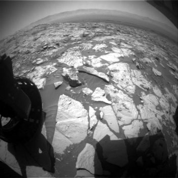
Vertical exposure
The plan on sol 1836 is to start with a remote sensing block that has the rover’s Chemistry and Camera (LIBS) observations of targets “Ecca” and “Lucknow.”
“These are the same targets we had planned to do contact science on yesterday. We are also taking Mastcam mosaics of target “Limpopo” and a nice vertical exposure that we may visit in the future,” Fraeman adds.
Mars scientists additionally managed to fit in a Mastcam tau observation and a Mastcam multispectral observation of an area named “Hotazel.” We will use the multispectral observation to document the spectral properties of the terrain in front of us.

Curiosity Mastcam Left photo taken on Sol 183, October 3, 2017.
Credit: NASA/JPL-Caltech/MSSS
Bedrock properties
After finishing the remote sensing science block, researchers will repeat contact science that they had planned. The purpose of these contact science measurements is to document the properties of the bedrock on this middle plateau on Vera Rubin Ridge. “We will also squeeze in one more Mastcam tau measurement and a crater rim extinction image before the sun sets,” Fraeman explains.
“Our main activity on sol 1837,” Fraeman concludes, “is a drive to the east to continue on our exploration of Vera Rubin Ridge. We will collect a Mastcam multispectral observation of the brushed targets Ecca and Lucknow before we drive away. Whew!”
Vice President Pence ✔@VP
At @POTUS’ direction, the Nat’l Space Council will hold first meeting with all aspects of space enterprise for 1st time in a quarter century.
The meeting, titled “Leading the Next Frontier: An Event with the National Space Council,” will be held today.
Credit: White House
This first meeting is to take place at the Smithsonian National Air and Space Museum’s Steven F. Udvar-Hazy Center in Chantilly, Virginia.
It will be chaired by Vice President Mike Pence and include participation by acting NASA Administrator Robert Lightfoot, as well as a number of Trump Administration cabinet members and senior officials, and aerospace industry leaders.
The council will hear testimonial from expert witnesses who represent the sectors of the space industry: Civil Space, Commercial Space, and National Security Space. President Trump signed an executive order reestablishing the National Space Council on June 30 of this year.

U.S. President Trump signing bring back the National Space Council.
Credit: White House
Pence: return to the moon
Vice President Pence has written a Wall Street Journal op-ed titled “America Will Return to the Moon—and Go Beyond,” in which he said the US space program will establish “a renewed American presence on the Moon, a vital strategic goal.”
The full text of that op-ed reads:
Sixty years ago this week, the Soviet Union launched the world’s first satellite into orbit, changing the course of history. The race for space was on, and the Soviets had taken an early lead. But the sight of Sputnik blinking across the October sky spurred Americans to action. Twelve years later, with “one giant leap for mankind,” the U.S. claimed its rightful place as the undisputed leader in the exploration of the heavens.
That pre-eminence in outer space is now under threat—and once again, America must act. President Trump has revived the National Space Council to assist him in developing and implementing long-range strategic goals for our nation’s space policy. On Thursday the council will hold its first meeting in nearly 25 years, and as its chairman, I will deliver a simple message: America will lead in space again.
More than ever, American prosperity and security depend on U.S. leadership in space. Yet national space policy often has lacked a coherent, cohesive vision. The results not only are disappointing; they endanger the well-being of the American people.

Vice President Mike Pence delivers opening remarks during the National Space Council’s first meeting, Thursday, Oct. 5, 2017 at the Smithsonian National Air and Space Museum’s Steven F. Udvar-Hazy Center in Chantilly, Va. The National Space Council, chaired by Vice President Mike Pence heard testimony from representatives from civil space, commercial space, and national security space industry representatives.
Credit: NASA/Joel Kowsky
The U.S. pays Russia more than $76 million a seat to carry American astronauts to the International Space Station, since we have no vehicle capable of performing this task. The intelligence community reports that Russia and China are pursuing a full range of antisatellite technology designed to threaten our military’s effectiveness. These are only two examples of America’s abdication of leadership in space.
The president has charged the National Space Council with restoring that leadership. The council’s objectives are clear.
We will refocus America’s space program toward human exploration and discovery. That means launching American astronauts beyond low-Earth orbit for the first time since 1972. It means establishing a renewed American presence on the moon, a vital strategic goal. And from the foundation of the moon, America will be the first nation to bring mankind to Mars.

Credit: ESA/NASA
We will renew America’s commitment to creating the space technology needed to protect national security. Our adversaries are aggressively developing jamming and hacking capabilities that could cripple critical military surveillance, navigation systems and communication networks. In the face of this threat, America must be as dominant in the heavens as it is on Earth.
We will promote regulatory, technological, and educational reforms to expand opportunities for American citizens and ensure that the U.S. is at the forefront of economic development in outer space. In the years to come, American industry must be the first to maintain a constant commercial human presence in low-Earth orbit, to expand the sphere of the economy beyond this blue marble.
To achieve these goals, the National Space Council will look beyond the halls of government for insight and expertise. In the coming weeks, President Trump and I will assemble a Users’ Advisory Group partly composed of leaders from America’s burgeoning commercial space industry. Business is leading the way on space technology, and we intend to draw from the bottomless well of innovation to solve the challenges ahead.
Above all, the National Space Council will enable our nation to bring American values to this infinite frontier. It will renew the American spirit itself, as we lift our heads and reach our hands toward the heavens, in pursuit of peace and hope for all mankind.
As the National Space Council meets Thursday, our nation can know with confidence: Under President Trump, America will lead in space again.
NOTE:
The meeting begins at 10:00 am ET with welcoming remarks from Pence. The Council then will hear from three panels of experts:
10:20-11:05 am ET: We Will Lead Again — Civil Space
Marillyn Hewson, President and CEO, Lockheed Martin
Dennis Muilenburg, President and CEO, Boeing
David Thompson, President and CEO, Orbital ATK
11:05 – 11:35 am ET: We Will Inspire Again — Commercial Space
Gwynne Shotwell, President and COO, SpaceX
Bob Smith, CEO, Blue Origin
Fatih Ozmen, owner and CEO, Sierra Nevada Corporation
11:35 – 12:05 pm ET: We Will Hold the High Ground Again — National Security Space
Michael Griffin, former NASA Administrator
Adm. James Ellis (Ret.), former Commander, U.S. Strategic Command
Pamela Melroy, former space shuttle commander and former Deputy Director, Tactical Technology Office, DARPA
12:05 pm ET: Concluding Remarks by Vice President Pence
Watch live:
NASA Television and the agency’s website will provide live coverage of the first meeting of the National Space Council starting at 10 a.m. EDT Thursday, Oct. 5.
Live Coverage of Vice President Mike Pence and the first meeting of the National Space Council at the Smithsonian National Air and Space Museum’s Steven F. Udvar-Hazy Center can be viewed here:

Credit: S.P. Korolev Rocket and Space Corporation/Energia
The roots of space exploration stem back to the launch of the first artificial satellite of Earth – the Soviet Union’s Sputnik 1.
Today, sixty years ago on October 4, 1957, the 184-pound polished sphere rocketed into Earth orbit. Its beep-beep-beeping sent scientific, technological, and political shockwaves around the world.

The dawn of the Space Age, and the start of the space race – the launching of a Soviet Union’s first articficial Earth satellite, Sputnik 1, on 4 October 1957 (5 October local time, Tyuratam)
Credit: ESA/RKK Energiya/Solaris
As American historian Daniel Boorstin noted: “Never before had so small and so harmless an object created such consternation.”
Go to this nicely produced European Space Agency Euronews: 60 years since Sputnik video on the milestone-making event:
http://www.esa.int/spaceinvideos/Videos/2017/09/ESA_Euronews_60_years_since_Sputnik
For those inclined (or want to be), how about a vodka toast, sit back, and listen to the sounds of Sputnik 1.
Go to:

Credit: Government of Dubai Media Office
The United Arab Emirates have launched the Mars Science City project. The initiative was unveiled at the annual meetings for the UAE government in Abu Dhabi last week.
This city, at 1.9 million square feet, would make it the largest space stimulation city ever built and will provide a viable and realistic model to simulate living on the surface of Mars. It would encompass laboratories for food, energy and water, as well as agricultural testing and studies about food security in the future.
Walls of sand
According to the Government of Dubai’s media office, the science city will also boast a museum that displays humanity’s greatest space achievements, including educational areas meant to engage young citizens with space, and inspire in them a passion for exploration and discovery. The walls of the museum will be 3D printed, using sand from the Emirati desert.

Credit: Government of Dubai Media Office
His Highness Sheikh Mohammed bin Rashid explained that the UAE “seeks to establish international efforts to develop technologies that benefit humankind, and that establish the foundation of a better future for more generations to come. We also want to consolidate the passion for leadership in science in the UAE, contributing to improving life on earth and to developing innovative solutions to many of our global challenges.”

Credit: Government of Dubai Media Office
Settlement on Mars
The Mars Science City project falls within the UAE’s objectives to lead the global scientific race to take people to Mars, and is part of the Mars 2117 Strategy, launched during the fifth World Government Summit, which seeks to build the first settlement on Mars in the next 100 years.
This project will include advanced laboratories that stimulate the Red Planet’s terrain and harsh environment through advanced 3D printing technology and heat and radiation insulation.
Live-in team
The Mars Science City project also includes an experiential element which will involve a team living in the stimulated city for one year. The Mars Science City structure when completed is billed as the most sophisticated building in the world, incorporating a realistic simulation environment replicating the conditions on the surface of Mars.

Credit: Government of Dubai Media Office
The city will consist of several domes, with innovative construction techniques providing support for the structures. A team of Emirati scientists, engineers and designers, led by a team from the Mohammed bin Rashid Space Centre and Dubai Municipality will carry out the project, in cooperation with internationally renowned architects from the BIG-Bjarke Ingels Group.

Curiosity Navcam Left B image acquired on Sol 1830, September 29, 2017.
Credit: NASA/JPL-Caltech
NASA’s Mars Curiosity rover has just entered Sol 1831.
In a report by Michael Battalio, an atmospheric scientist from Texas A&M University in College Station, the robot has performed touch-and-go science on a dark-toned target named “Collingham” in the hopes that the darker color indicated either a different chemistry or reduced surface dust.

“Tra Tra” is the large outcrop at the top left of the above image, with Mt. Sharp is to the right.
Curiosity Navcam Left B photo taken on Sol 1829, September 28, 2017.
Credit: NASA/JPL-Caltech
Curiosity’s Alpha Particle X-Ray Spectrometer (APXS), the Mars Hand Lens Imager (MAHLI), the Chemistry and Camera (ChemCam) and the rover’s Mastcam will all cooperate on observing this target.
Imaging campaign
The rover’s Mastcam will continue a Vera Rubin Ridge imaging campaign by capturing a 13×1 mosaic of a prominent outcrop, named “Tra Tra,” which is a large outcrop. A stereo image was to be taken to ascertain the geometry of the bedding.
Curiosity Front Hazcam Left B image taken on Sol 1830, September 29, 2017.
Credit: NASA/JPL-Caltech
Curiosity was then slated to drive about 35 feet (11 meters) towards the top of a nearby ridge. Post-drive Navcam imaging is to be taken as well as use of automated software for imaging, Battalio reports.

Curiosity Mastcam Right image acquired on Sol 1828, September 27, 2017.
Credit: NASA/JPL-Caltech/MSSS
New map
A new map has been posted showing the route driven by Curiosity through the 1827 Martian day, or sol, of the rover’s mission on Mars – as of September 27, 2017.

Credit: NASA/JPL-Caltech
Numbering of the dots along the line indicate the sol number of each drive North is up. The scale bar is 1 kilometer mile From Sol 1822 to Sol 1827.
Curiosity had driven a straight line distance of about 30.86 feet (41 meters) bringing the rover’s total odometry for the mission to 10.84 miles (17.45 kilometers).
The base image from the map is from the High Resolution Imaging Science Experiment Camera (HiRISE) on NASA’s Mars Reconnaissance Orbiter.

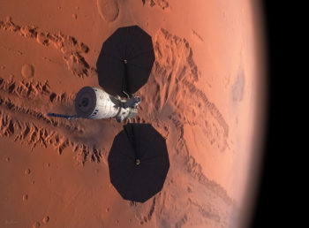
Credit: Elon Musk/SpaceX
This week at the International Astronautical Congress (IAC) in Adelaide, Australia, SpaceX CEO and Lead Designer Elon Musk provided an update to his 2016 presentation regarding the long-term technical challenges that need to be solved to support the creation of a permanent, self-sustaining human presence on Mars.

Credit: Elon Musk/SpaceX
Moon, Mars, Earth-to-Earth
Musk spotlighted his “BFR” plans, a vehicle capable of transporting satellites to orbit, crew and cargo to the space station and completing missions to the Moon and Mars.

Credit: Elon Musk/SpaceX
Also, the SpaceX BFR will be capable of taking people from any city to any other city on Earth in under one hour.
Credit: Elon Musk/SpaceX
“In Musk we Trust,” responded one viewer. “Maybe this presentation will be for Mars, what Kennedy’s speech was for the Apollo program,” said another.

Credit: Elon Musk/SpaceX
Resources
To view the Musk presentation, go to:
https://www.youtube.com/watch?time_continue=17&v=S5V7R_se1Xc
Go to SpaceX masterplan for Mars video at:
https://twitter.com/twitter/statuses/913634039545847808
Go to BFR – Earth to Earth video at:
For an expert review of Elon Musk’s talk go to this Australian Science Channel analysis straight after his SpaceX presentation.
Joining host and astronomer Alan Duffy is Adam Gilmour, CEO of Aussie space start up Gilmour Space Technologies, Michael Lopez-Alegria, NASA astronaut, and Beth Jens, propulsions engineer.
Go to:
https://www.facebook.com/RiAus/videos/10155810461416462/
Lastly, a critique of the SpaceX Interplanetary Transport System and Colonizing Mars by Robert Zubrin, leader of the Mars Society, is available here at:
http://www.thenewatlantis.com/publications/colonizing-mars
Credit: Elon Musk/SpaceX
This week at the International Astronautical Congress (IAC) in Adelaide, Australia, SpaceX CEO and Lead Designer Elon Musk will provide an update to his 2016 presentation regarding the long-term technical challenges that need to be solved to support the creation of a permanent, self-sustaining human presence on Mars.
You can watch the talk live on Thursday, September 28th at 9:30 p.m. PDT,
or Friday, September 29th at 2:00 p.m. ACST in Adelaide, Australia.
Go to: http://www.spacex.com/mars

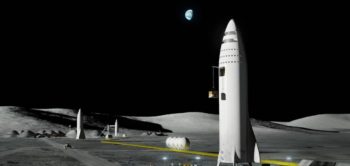
Credit: Lockheed Martin
Mars Base Camp is Lockheed Martin’s concept for sending humans to Mars in about a decade. Using NASA’s Orion spacecraft as the command deck, the orbiting outpost could give scientists/astronauts the ability to operate rovers and drones on the Red Planet’s in real time.
Lockheed Martin is rolling out new details of the concept at the International Astronautical Congress now underway in Adelaide, Australia.
Mission architecture
According to the company, Mars Base Camp is a vision of how to send humans to Mars in about a decade – a mission architecture centered around an orbital outpost where scientist-astronauts can perform real-time scientific exploration of Mars.
Mars Base Camp is aligned with NASA’s recently-announced lunar Deep Space Gateway approach for developing and testing systems, including Orion, in cis-lunar space before using them to go to Mars. The Gateway allows astronauts to live and work in orbit around the Moon for months at a time while gaining experience with extended operations far from Earth.
Credit: Lockheed Martin
First mission
“Mars Base Camp’s first mission is intended to be an orbiting mission around the Red Planet. Following this, the architecture allows for a surface lander. The concept is designed to be a reusable, single-stage lander capable of descending to the surface from Mars orbit,” states a company press statement. “Each surface mission could last two weeks with up to four astronauts, and then return to the orbiting Mars Base Camp where it would be refueled and readied for another mission.”
A webcast (live or replay) of the Mars Base Camp presentation from the Australian space gathering can be viewed on the Australia Science Channel web site:
https://www.australiascience.tv/live-from-the-68th-iac-lockheed-martins-mission-to-mars/
Here’s a video about Mars Base Camp:
https://www.youtube.com/watch?v=vLpZUMfIJX0
For more information on this innovative approach to human exploration of Mars, go to my older Space.com story at:
‘Mars Base Camp’: Lockheed Fleshes Out Red Planet Space Station Plan
By Leonard David, Space.com’s Space Insider Columnist
April 3, 2017 08:00am ET
http://www.space.com/36312-mars-base-camp-astronauts-2028.html

Curiosity Navcam Left B image taken on Sol 1828, September 27, 2017.
Credit: NASA/JPL-Caltech
NASA’s Curiosity rover on Mars is now in Sol 1829.
“We have officially left the ‘Bar Harbor’ quadrangle and are now into the ‘Kuruman’ quadrangle,” reports Abigail Fraeman, a planetary geologist at the NASA Jet Propulsion Laboratory in Pasadena, California.
Fraeman notes that during the first full sol in the Kuruman quad, the rover will be doing a touch-and-go.
Erosion-resistant outcrop
The robot is slated to investigate the target “Enon” with its Alpha Particle X-Ray Spectrometer (APXS) and the Mars Hand Lens Imager (MAHLI), the Chemistry and Camera (ChemCam) and use its Mastcam.
“We are also currently sitting in front of an erosion-resistant outcrop, ‘Mt. Hamden,’ which is providing us with a nice vertical exposure that we will image with Mastcam left and right eyes,” Fraeman says.
Curiosity Front Hazcam Left B image acquired on Sol 1828, September 27, 2017.
Credit: NASA/JPL-Caltech
Finally, another Mastcam image of target “Noisy” will be taken before the robot drives off to the northeast.
The day will end with some environmental science monitoring observations including a Mastcam tau measurement to assess the dust content of the atmosphere, and some Navcam images looking towards the sky and crater rim, Fraeman says.
Iron formation
Regarding the Kuruman quadrangle, Fraeman notes it is named after a charming town situated on the edge of the Kalahari desert in South Africa. Notably, the town of Kuruman is the namesake for the Kuruman Iron Formation, an ~2.46 billion year sedimentary rock that is rich in hematite.

Curiosity Navcam Right B photo taken on Sol 1828, September 27, 2017.
Credit: NASA/JPL-Caltech
“Hematite is the same mineral we can see is distributed throughout the Vera Rubin Ridge from orbital data! The target names we will use while in this quadrangle are pulled from famous geological features from South Africa and nearby Botswana and Zimbabwe,” Fraeman concludes.

This picture of the Curiosity arm’s shadow on the ground was taken just before a fault.
Front Hazcam Right B image taken on Sol 1826, September 25, 2017.
Credit: NASA/JPL-Caltech
Now in Sol 1827, NASA’s Curiosity rover has faulted itself and is staying put on Vera Rubin Ridge.
“Just when we thought we were going to leave this spot on Mars, we found ourselves stuck here for yet another sol,” reports Scott Guzewich, an atmospheric scientist at NASA’s Goddard Space Flight Center in Greenbelt, Maryland.
Recovery mode
This time, a fault during one of Curiosity’s arm activities caused scientists to toss out plans for the past two sols. Those plans included a drive of the robot to the next waypoint in the Vera Rubin Ridge science campaign.
Curiosity is in a recovery mode, Guzewich adds. For Sol 1827, “It’s déjà vu all over again.”

Curiosity Navcam Left B photo acquired on Sol 1827, September 26, 2017.
Credit: NASA/JPL-Caltech
Third attempt
The current plan calls for Curiosity controllers to make their third attempt to complete science activities at the rover’s current stop, including Chemistry and Camera (ChemCam) and Mastcam targets of nearby bedrock: “Sherwood Forest”, “Tableland”, and “Troll Valley.”
Curiosity Rear Hazcam Right B Sol 1827 September 26, 2017
Credit: NASA/JPL-Caltech
“We were also able to plan a Mastcam image of a target named “Elf Woods” that was originally intended for the weekend plan, but had to be removed for power consideration,” Guzewich concludes. “Following these science activities, Curiosity will drive approximately 10 meters [33 feet] closer to our third stop on Vera Rubin Ridge.”

