Archive for the ‘Space News’ Category

Cargo carrying Peregrine lander.
Credit: Astrobotic
To preserve and disseminate humanity’s most important knowledge across time and space feels like a Star Trek imperative.
Astrobotic and the Arch Mission Foundation have partnered to land the “Lunar Library” on Astrobotic’s first robotic lander mission to the Moon in 2020.
That Lunar Library will include the Wikipedia, and the Long Now Foundation’s Rosetta Project, a digital library of human languages. Additional content and data for the Lunar Library is to be announced in the coming year.
Analog microfiche
Astrobotic will carry the Lunar Library to the Moon on its Peregrine Lunar Lander and store it on the lunar surface. The Lunar Library consists of a set of tens of millions of pages of text and images stored as analog microfiche on thin sheets of nickel. Each page is etched by laser at 300,000 dpi using patented nanolithography technology provided exclusively to the Arch Mission Foundation by Stamper Technologies.

Commercial interest in returning to the Moon.
Photo Credit: NASA/GSFC
The content of the Library can easily be read via a 1000x magnification optical microscope, without needing a computer. Nickel is impervious to radiation as well as the changing temperatures on the Moon, and can last for millions to billions of years in space.
Cold storage
John Thornton, CEO of Astrobotic said in a press statement: “It’s humbling to think our mission to the Moon will deliver something that could be read millions of years from now. Arch’s Lunar Library will be a monument not only to human knowledge and culture, but also the first commercial mission to the Moon.”
Along with the library, the Peregrine Lunar Lander has a manifest of other payloads from governments, companies, universities, nonprofits, and individuals.
“Through massive replication around the solar system we will be able to guarantee that the Arch Libraries will never be lost even millions to billions of years in the future,” said Nova Spivack, cofounder and Chairman of the Arch Mission Foundation.
“We can definitely preserve our unique cultural heritage and biological record in a way that will survive for millions to billions of years,” Spivack adds, “and that has not been possible before. We see the Lunar Library as the ultimate in cold storage for human civilization.”

Credit: SpaceX
Long-term “arkives”
The Lunar Library follows the Arch Mission’s initial foray into space with the Solar Library, launched aboard SpaceX’s first Falcon Heavy flight earlier this year – yes, the one that hurled the Tesla roadster into space. The first books in the Solar Library are Isaac Asimov’s Foundation Trilogy.
The Arch Mission Foundation designs, builds, delivers and maintains curated longterm archives that are housed in specially designed devices called Arch Libraries (pronounced “Arks”). Arch Libraries are being developed with a variety of form factors to survive for long durations in space, as well as on the surfaces of planets, moons and asteroids.

The Red Planet as seen by Europe’s Mars Express.
Credit: ESA/D. O’Donnell – CC BY-SA IGO
Future plans
The Arch Libraries may last billions of years longer than the Pyramids. They may even last longer than our planet. In a million years the Arch Libraries may be the only remaining trace of our species and our civilization, states the group.
The Mars Library is planned, and will be designed to supply a future human settlement on Mars with a vast collection of important knowledge from Earth. This will form a backup of Earth on Mars, in the event that the connection between Mars and Earth is ever lost in the future. It will also provide colonists on Mars with a massive data set with which to seed a local Internet and Web on Mars.
For more information, visit Astrobotic at:
The Arch Mission Foundation is available at:
Take a look at this video at:

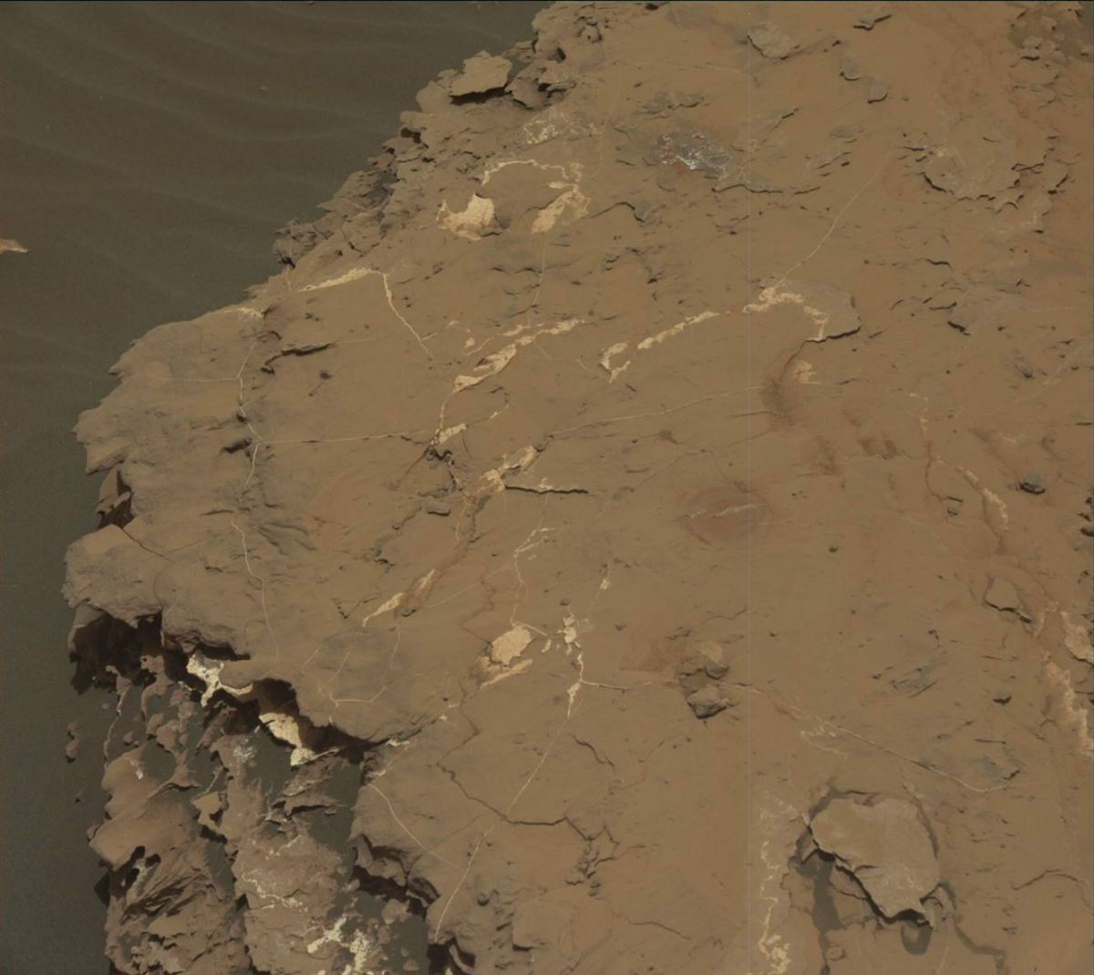
Curiosity Front Hazcam Right B image taken on Sol 2051, May 14, 2018.
Credit: NASA/JPL-Caltech
NASA’s Curiosity Mars rover is working Sol 2052 science duties. However, a recent drive did not wheel the rover into an expected spot.
“We’ve been here before,” reports Scott Guzewich, an atmospheric scientist at NASA’s Goddard Space Flight Center in Greenbelt, Maryland: “Rather than driving almost 11 meters, Curiosity only drove about 1/2 meter before stopping. So, we found ourselves looking at images of previous wheel tracks and contact science targets rather than a new location.”
Curiosity Mastcam Left image acquired on Sol 2050, May 13, 2018.
Credit: NASA/JPL-Caltech/MSSS
New drilling attempt
Scientists had expected to start examining a new location within the robot’s arm reach (or a very short drive’s reach) of a possible location for a next drilling attempt.
The priority now is to recover that drive, which left plenty of time for some additional targeted and untargeted science.
This included instrument looks at “Brownell” and “Mahtowa”, additional Mastcam images of “Munger” and “Itasca”, and taking a Navcam dust devil movie.
Dust devils
Following the drive, the plan calls for Curiosity to use Chemistry and Camera (ChemCam) specialized software – Autonomous Exploration for Gathering Increased Science (AEGIS). That software autonomously directs the robot’s cameras to interesting science targets.

Curiosity Mars Hand Lens Imager (MAHLI) photo produced on Sol 2050, May 13, 2018.
Credit: NASA/JPL-Caltech/MSSS
Along with AEGIS activity, the rover will make a longer version of a Navcam dust devil movie.
“We often schedule dust devil movies closer to midday, when dust devils are more common, but it’s important to also observe at other times of day to understand their frequency and patterns,” Guzewich explains.

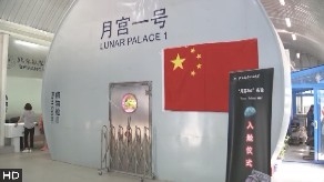
China’s Lunar Palace 1 – an experimental biosphere here on Earth.
Credit: CMSE
Chinese student volunteers have completed a one-year test living in a simulated space lab in Beijing on May 15, setting a new record for the longest stay in a self-contained cabin: Yuegong-1, or Lunar Palace 1.
The Moonlab program is staged at Beihang University.
As reported by the state-run Xinhua news agency, the total length of the test, which started on May 10 last year, was 370 days, with the third stage accounting for 110 days.
Co-existing in closed environment
Liu Hong, chief designer of Yuegong-1, said the test marked the longest stay in a bioregenerative life support system (BLSS), in which humans, animals, plants and microorganisms co-exist in a closed environment, simulating a lunar base. Oxygen, water and food are recycled within the BLSS, creating an Earth-like environment.
Eight student volunteers took turns living in the cabin, which measures around 150 square meters. The BLSS is a critical piece of technology required for long-term human stays on the Moon or other extraterrestrial bodies, Liu said.

Inside look at one area of China’s Lunar Palace 1.
Credit: CMSE
New starting point
The cabin consists of two plant cabins and a comprehensive cabin. Liu said the BLSS system had proven to function well over a long period of time. Researchers have also explored the mechanism in which light affects human’s biological rhythms and emotions. They also improved technology for vertical planting, the Xhinua story explains. “This is not the end, but a new starting point to continue to explore space,” Liu said.
Researchers will evaluate the physical and mental conditions of volunteers, study test results, and explore smaller BLSS equipment which could be loaded onto space labs, and Moon and Mars probes in the future.
“The test has important implications for human endeavors to achieve long-term stays outside Earth. The experience, technology and findings will be conducive for future space exploration efforts,” said Wang Jun, an academician from the Chinese Academy of Engineering.
Credit: CCTV-Plus
Integrative experimental facility
Lunar Palace 1 is short for the Integrative Experimental Facility for Permanent Astrobase Life-support Artificial Closed Ecosystem (PALACE) Research.
Construction on the Lunar Palace 1 capsule began in March 2013. The facility was unveiled in January 2014, and it was commissioned just prior to the first mission starting in February 2014.

Credit: Jilin Provincial Government
By 2030, there will be an estimated 11,631 launch demands for new constellation installations and replacement missions, which could take the market past the $62 billion mark.
That projection comes from the London-based Frost & Sullivan’s recent analysis, “Small-satellite Launch Services Market, Quarterly Update Q1 2018, Forecast to 2030.”
Launch demand
The evolution of small satellites from technology demonstrators to providers of low-cost operational services across distributed industry segments is attracting launch demand from organizations all over the world.

Credit: OneWeb
As the lifespan of these satellites is between two years and five years, there will be constant launch demand and participants will look to enhance their systems and infrastructure.
Business model
Observes Vivek Suresh Prasad, the group’s Space Industry Principal, Aerospace & Defense:
“While North American and European companies will be the leading developers of flexible, dedicated launch vehicles, players in Asia-Pacific are looking to follow suit,” he said in a press statement. “Many players are also analyzing the feasibility of the small-satellite spaceport business model to provide dedicated launch services to small-satellite operators.”
Rideshare insufficient
According to a Frost & Sullivan statement:
“The high volume of launch demand for small satellites is driving satellite operators to increase their launch capacity. The current rideshare capacity is insufficient to meet the upcoming launch demand. Most small satellites use the rideshare capacity as a secondary payload on existing launches. This makes their project schedule and mission requirements dependent on the primary payload. Many incumbent and emerging commercial operators are preparing for the impending capacity expansion by providing dedicated services and launch flexibility to small-satellite operators.”

Credit: Planet
Production challenges
Once the unit shipment needs are met, the market could grow impressively. Some key numbers are outlined below:
— The total projected launch capacity supply, including the success of multiple dedicated planned launch services, is 11,640 small satellites.
— In this case, a total payload mass of 2,473 tons can be potentially launched.
— Small satellites in the mass segments of 0 to 15 Kilograms and 150 to 500 Kg could account for as much as 65 percent of the small-satellite launch demand. Thirty-two small-satellite commercial operators will generate more than 90% of the launch demand.
“The key to resolving production challenges is to standardize, optimize and deploy low-rate serial production lines for small satellites and the launch hardware for the relevant launch vehicles,” added Vivek.
For further information on this analysis, please contact jacqui.holmes@frost.com
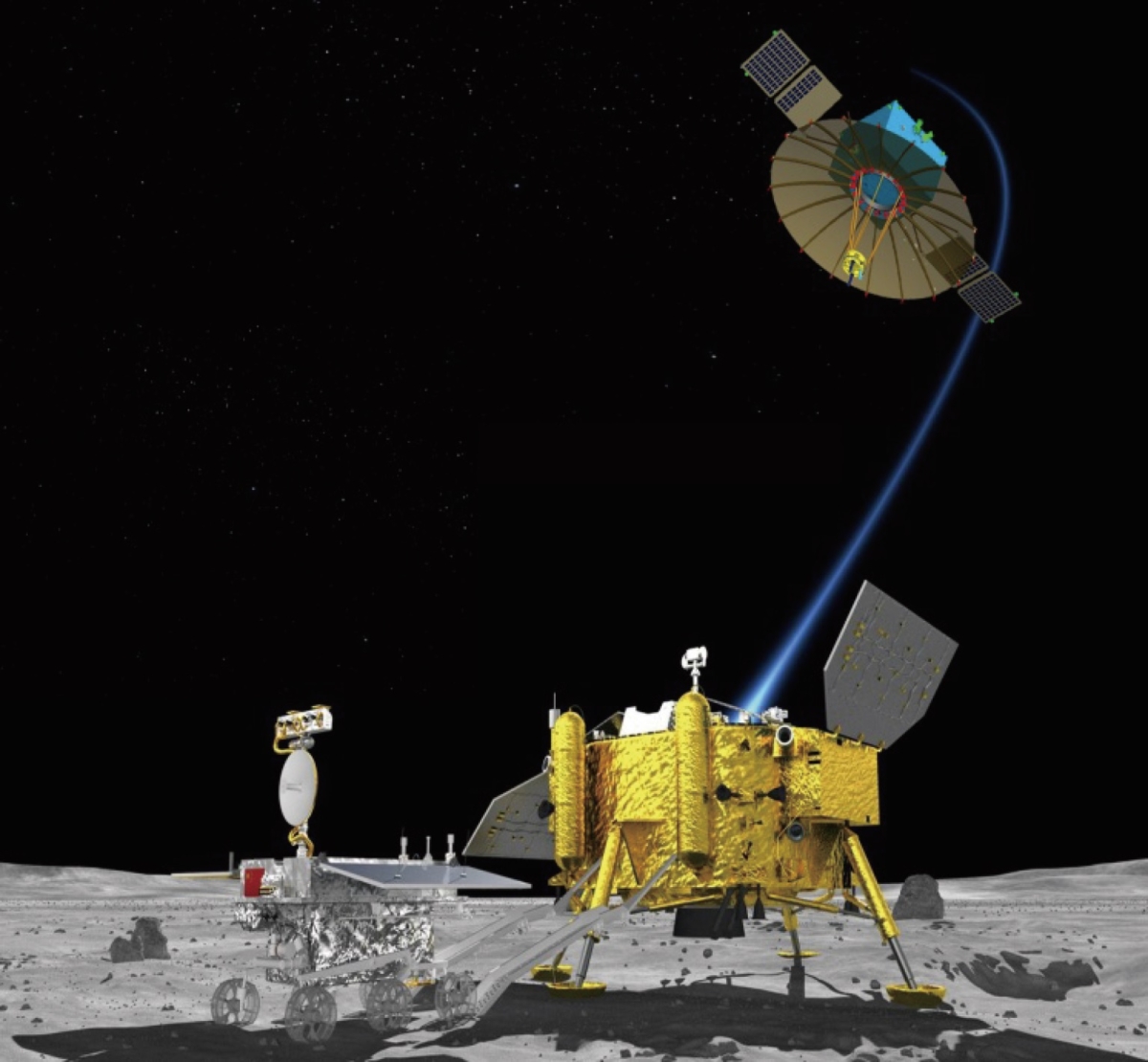
Chang’e-4 Moon lander and rover.
The first phase of China’s bid to land a robotic mission on the far side of the Moon is reportedly nearing launch.
A projected May 21 launch of a Long March-4C booster is topped by a relay satellite named Queqiao (Magpie Bridge). This spacecraft is to be dispatched into a halo orbit of the Earth-Moon Lagrange Point L2 and relay signals between the Earth and the Chang’e-4 far side lander which will deploy a rover.
Meanwhile, China’s tracking ship Yuanwang 6 recently departed from a port in East China’s Jiangsu province to monitor the trajectory of Queqiao, the Chang’e-4 relay satellite.
Together with Queqiao, two microsatellites — “Longjiang-1” and “Longjiang-2” developed by the Harbin Institute of Technology — will also be sent into orbit to conduct scientific research.
![]()
Radio astronomy
The relay spacecraft is multifaceted. It carries the Netherlands-China Low-Frequency Explorer (NCLE) built by a team of scientists and engineers from ASTRON (the Netherlands Institute for Radio Astronomy in Dwingeloo), the Radboud Radio Lab of Radboud University in Nijmegen, and the Delft-based company, ISIS.
NCLE is considered a pathfinder mission for a future low-frequency space-based or Moon-based radio interferometer.
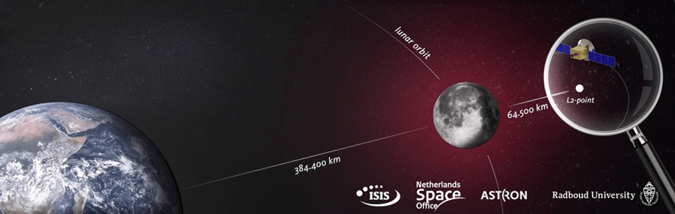
The constellation of three active NCLE antennas is mounted perpendicular to the upper side of the satellite body. The final assessment of the instrument took place early April in Beijing, clearing the way for the integration of the radio antenna package on the Chinese relay satellite.
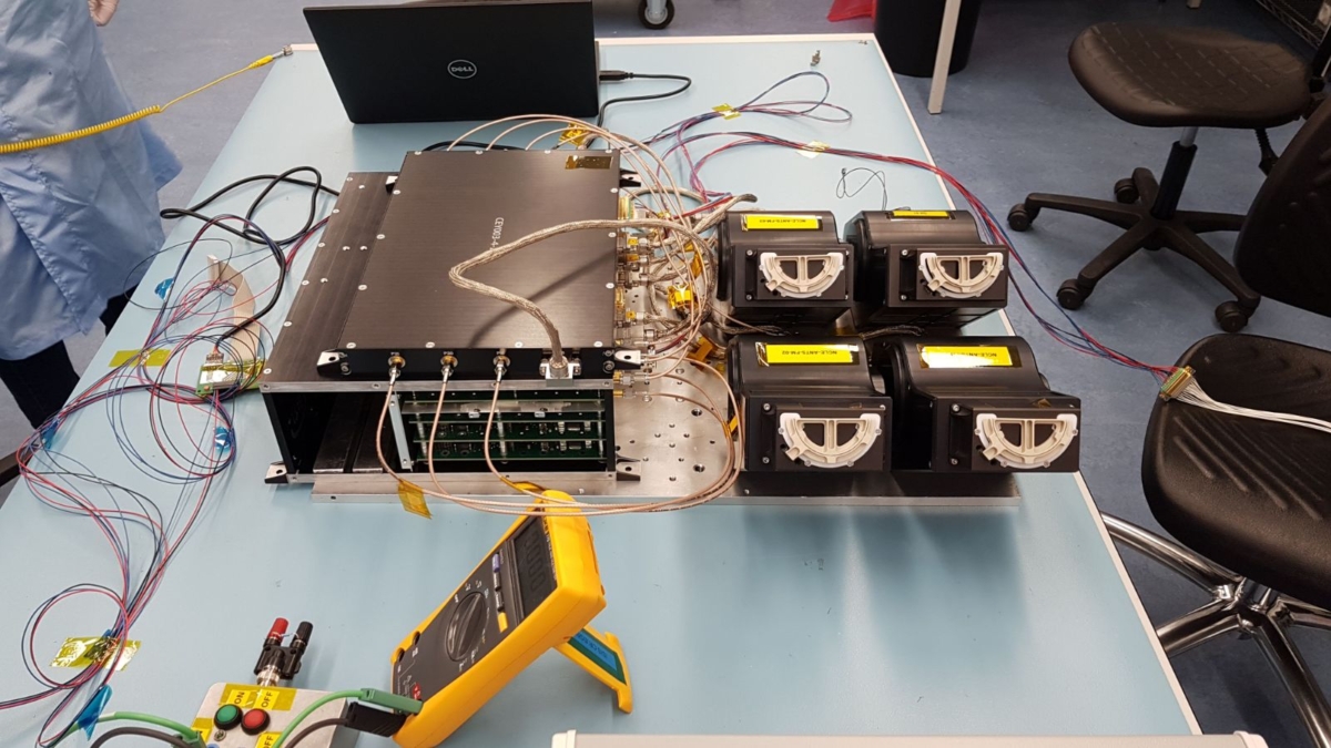
Netherlands-China Low-Frequency Explorer (NCLE) hardware undergoes testing.
Credit: Astron
The objective of the NCLE mission is two-fold. In addition to the characterization of the lunar radio environment, NCLE will allow for radio science and astronomy, including constraining the 21-cm line Dark Ages and Cosmic Dawn signal, measuring the auroral radio emission from the large planets in our Solar system, determining the radio background spectrum at the Earth-Moon L2 point, studying the Solar activity and space weather at low frequencies, creation of a new low-frequency map of the radio sky, and study the Earth’s ionosphere and its interaction.
Far side mission
Chang’e-4 is to be sent to the Moon atop a Long March 3B booster with liftoff expected in late December.
According to the state-run Xinhua news agency, the lander will carry a tin containing seeds of potato and arabidopsis, a small flowering plant related to cabbage and mustard. It may also tote along silkworm eggs to conduct the first biological experiment on the Moon.
Courtesy: Philip Stooke
This “lunar mini biosphere” experiment was designed by 28 Chinese universities, led by southwest China’s Chongqing University, The cylindrical tin, made from special aluminum alloy materials, weighs roughly 7 pounds (3 kilograms).
The tin also contains water, a nutrient solution, and air. A tiny camera and data transmission system allows researchers to keep an eye on the seeds and see if they blossom on the Moon.
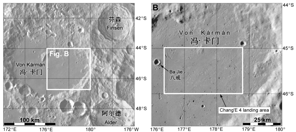
Candidate landing region
The candidate landing region for the Chang’e-4 lander mission – expected to be hurled moonward this December — is 45°S-46°S 176.4°E-178.8°E, which is in the southern floor of the Von Kármán crater, within the South Pole-Aitken (SPA) basin.
Chang’e-4 will carry payloads for Germany, the Netherlands, Saudi Arabia and Sweden.
China’s lunar exploration program is designed to be conducted in three phases. The first phase is to orbit the Moon, which was completed by Chang’e-1 in 2009. The second phase is to land on the Moon, which was done by Chang’e-3 in 2013. The third phase is to collect samples and return them to the Earth, which will be advanced by Chang’e-4, Chang’e-5 and Chang’e-6.
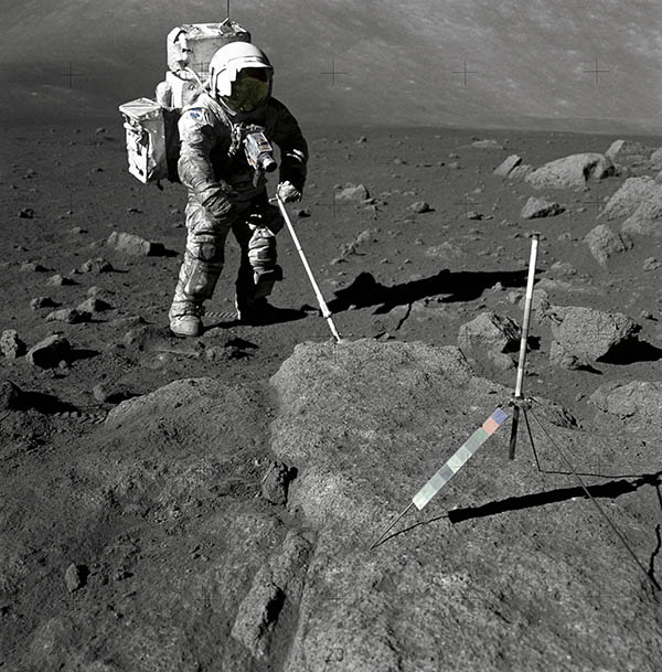
Geologist Harrison Schmitt performs Moon tasks during Apollo 17 mission in December 1972. Note suit covered by lunar dust.
Credit: NASA
New research finds breathing lunar dust could cause health problems for astronauts spending long periods of time on the Moon.
Researchers at New York’s Stony Brook University find simulated lunar soil is toxic to human lung and mouse brain cells. Up to 90 percent of human lung cells and mouse neurons died when exposed to dust particles that mimic soils found on the Moon’s surface, according to a press statement.
“If there are trips back to the Moon that involve stays of weeks, months or even longer, it probably won’t be possible to eliminate that risk completely,” said Bruce Demple, a biochemist at Stony Brook University School of Medicine and senior author of the new study.
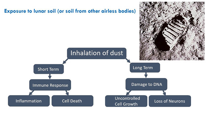
Flow chart shows the possible health effects of breathing lunar dust, in both the short- and long-term.
Credit: Rachel Caston
Hay fever-like reactions
Demple explains that Moon dust caused reactions similar to hay fever in astronauts who visited the lunar surface during the Apollo missions. Their experience coupled with the new study’s results suggest prolonged exposure to lunar dust could impair airway and lung function.
If the dust induces inflammation in the lungs, it could increase the risk of more serious diseases like cancer, Demple said.

Apollo 17 helmets and spacesuits stuffed inside lunar lander following the last human treks on the Moon in December 1972.
Credit: NASA
Lunar simulants
In the new study, Rachel Caston, a geneticist at Stony Brook University School of Medicine and lead author said human lung cells and mouse brain cells were exposed to several types of lunar soil simulants – soil found here on Earth that mimics the lunar highlands and the Moon’s volcanic plains. For example, JSC-1A simulant is low-titanium mare volcanic ash from Arizona that resembles lunar maria. Also used was a simulant from the Colorado School of Mines, developed from Colorado lava.
Caston grew the cells under controlled conditions and exposed them to the various types of dust. She counted how many cells were left and measured whether the simulants caused DNA damage. She and her colleagues found all the simulant types killed or damaged the cells’ DNA to some degree.
Simulants ground to a powder fine enough to be inhaled killed up to 90 percent of both cell types. The simulants killed the human lung cells so effectively the researchers couldn’t measure the DNA damage. The simulants also caused significant DNA damage in mouse neurons.
The study “Assessing Toxicity and Nuclear and Mitochondrial DNA Damage Caused by Exposure of Mammalian Cells to Lunar Regolith Simulants” was supported by a grant from NASA and appears in GeoHealth, a journal of the American Geophysical Union and can be found here:
https://agupubs.onlinelibrary.wiley.com/doi/epdf/10.1002/2017GH000125
Credit: NASA/JPL
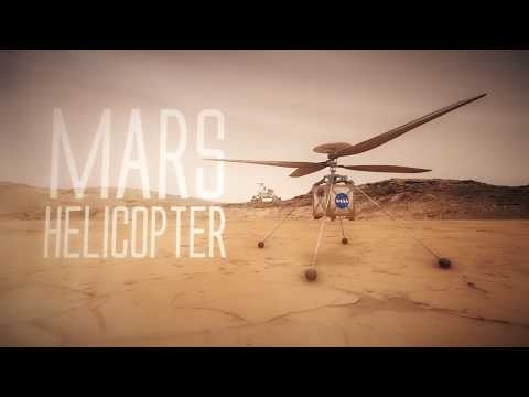
The Mars Helicopter, a small, autonomous rotorcraft, will travel with the agency’s Mars 2020 rover mission, currently scheduled to launch in July 2020, to demonstrate the viability and potential of heavier-than-air vehicles on the Red Planet.
Started in August 2013 as a technology development project at NASA’s Jet Propulsion Laboratory, the Mars Helicopter had to prove that big things could come in small packages. The result of the team’s four years of design, testing and redesign weighs in at little under four pounds (1.8 kilograms). Its fuselage is about the size of a softball, and its twin, counter-rotating blades will bite into the thin Martian atmosphere at almost 3,000 rpm — about 10 times the rate of a helicopter on Earth.
The helicopter also contains built-in capabilities needed for operation at Mars, including solar cells to charge its lithium-ion batteries, and a heating mechanism to keep it warm through the cold Martian nights. But before the helicopter can fly at Mars it has to get there. It will do so attached to the belly pan of the Mars 2020 rover.
As a technology demonstration, the Mars Helicopter is considered a high-risk, high-reward project. If it does not work, the Mars 2020 mission will not be impacted. If it does work, helicopters may have a real future as low-flying scouts and aerial vehicles to access locations not reachable by ground travel.
Go to video at:

Credit: NASA
Over a span of 20 years, the vision of an international orbiting outpost—one with continuous human presence, measuring the size of a football field, and orbiting the Earth every 90 minutes—became a reality.
The International Space Station (ISS) has been labeled an engineering miracle – a facility that also expresses vision, leadership, perseverance, political support, and funding.
The ISS enables world-class scientific research, forges pathfinders for future exploration travel, and unites 15 international partners working together with common goals to keep the ISS viable.
The ISS is part of NASA’s ongoing, deliberate, step-by-step approach for expanding the boundaries associated with human spaceflight exploration that will return humans to the Moon and eventually to inhabiting Mars.
A new NASA book – available for free as an e-book – is titled: The International Space Station: Operating an Outpost in the New Frontier. Robert Dempsey is the Executive Editor of this informative book.

International Space Station.
Credit: NASA
Real time, continuous
In the book’s preface, Dempsey explains: “This is an unusual book. Half the chapters are devoted to operations, meaning what we do in real time during a mission. For the International Space Station, real time is continuous 365 days a year, 24 hours a day. These chapters will describe different operational aspects of “flight control.” However to get the full context, the remaining chapters will provide technical descriptions of the primary space station systems. Although not strictly required to understand the operations, they are intended to provide more information for proper context.
Chapters include: Living and Working in Space and on the Ground; Debris Avoidance—Navigating the Occasionally Unfriendly Skies of Low-Earth Orbit; When Major Anomalies Occur; as well as Vital Visiting Vehicles—Keeping the Remote Outpost Crewed and Operating.
The 400-page book brings together the collective knowledge of the 10 space station flight directors who authored it, drawing on their combined 45,000 hours of experience at the helm of mission control. In addition to Dempsey, they are Dina Contella, David Korth, Michael Lammers, Courtenay McMillan, Emily Nelson, Royce Renfrew, Brian Smith, Scott Stover and Ed Van Cise.
This new NASA e-book is available at:
https://www.nasa.gov/sites/default/files/atoms/files/iss-operating_an_outpost-tagged.pdf

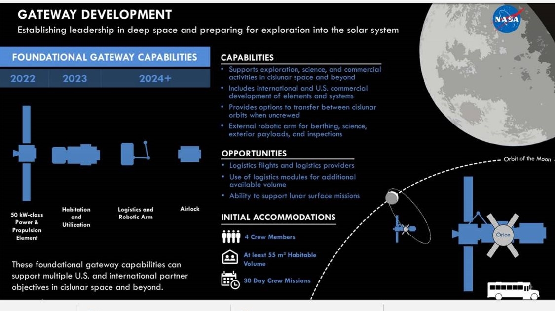
Notional design of Lunar Orbital Platform-Gateway.
Credit: Lockheed Martin
NASA’s Exploration Campaign calls for establishment of U.S. preeminence in cislunar space through the operations and the deployment of a U.S.-led Lunar Orbital Platform-Gateway.
Together with the Space Launch System (SLS) and the Orion spacecraft, the Gateway has been deemed central to advancing and sustaining human space exploration goals. NASA sees it as a unifying single stepping off point in creating architecture for human cislunar operations, lunar surface access and missions to Mars.
Credit: NASA
Directive 1
The gateway is necessary to achieving the exploration campaign goals set forth by the White House Space Policy Directive 1.
NASA has published a memorandum outlining the agency’s plans to collaboratively build the Gateway.
This document is available at:
Curiosity Navcam Left B image taken on Sol 2047, May 10, 2018.
Credit: NASA/JPL-Caltech
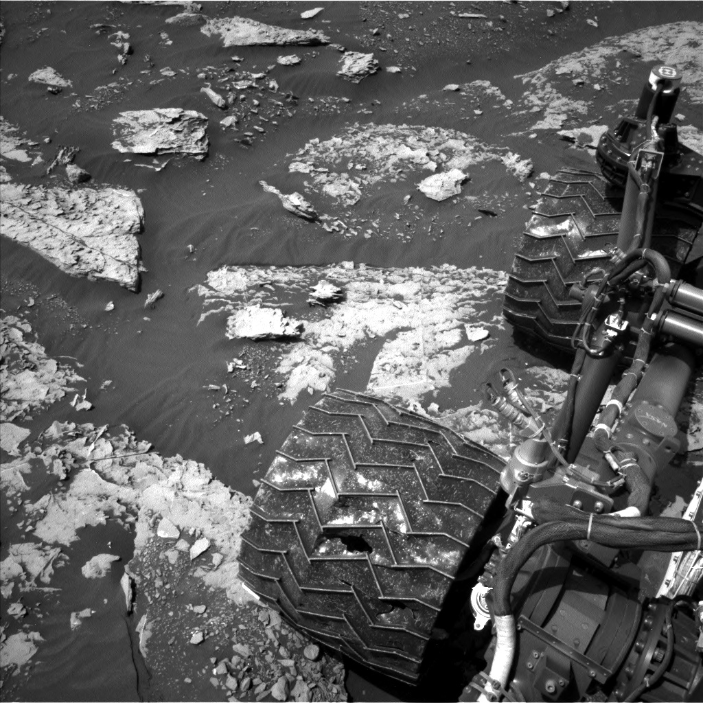
NASA’s Curiosity Mars rover is now in Sol 2048 after completing a successful bump, a short drive that was slated for Sol 2046, reports Ken Herkenhoff, a planetary geologist at the USGS in Flagstaff, Arizona.
The robot is now in a good position for contact science on a couple of bright blocks in front of the Mars machinery.
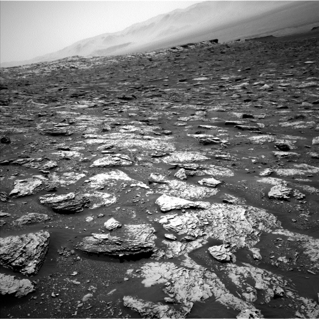
Curiosity Navcam Left B image acquired on Sol 2047, May 10, 2018.
Credit: NASA/JPL-Caltech
Two targets
The current plan, Herkenhoff explains, calls for Curiosity to brush two targets on the larger block, named “Bilbert” and “Giants Range,” before Mars Hand Lens Imager (MAHLI) images them and the Alpha Particle X-Ray Spectrometer (APXS) measures their chemistry at night.
Before the arm activities, the Chemistry and Camera (ChemCam) will shoot its laser at Giants Range and targets “Vermillion” and “Lac La Croix” on nearby blocks.

Curiosity Navcam Left B image taken on Sol 2047, May 10, 2018.
Credit: NASA/JPL-Caltech
Contact science
“Because the stowed arm partly blocks our view of the part of the arm workspace closest to the rover, we’ll acquire a Navcam stereo pair and a single Left Mastcam color image of that area after the arm is deployed,” Herkenhoff adds. “These images will be useful in planning more contact science this weekend.”

