Archive for the ‘Space News’ Category
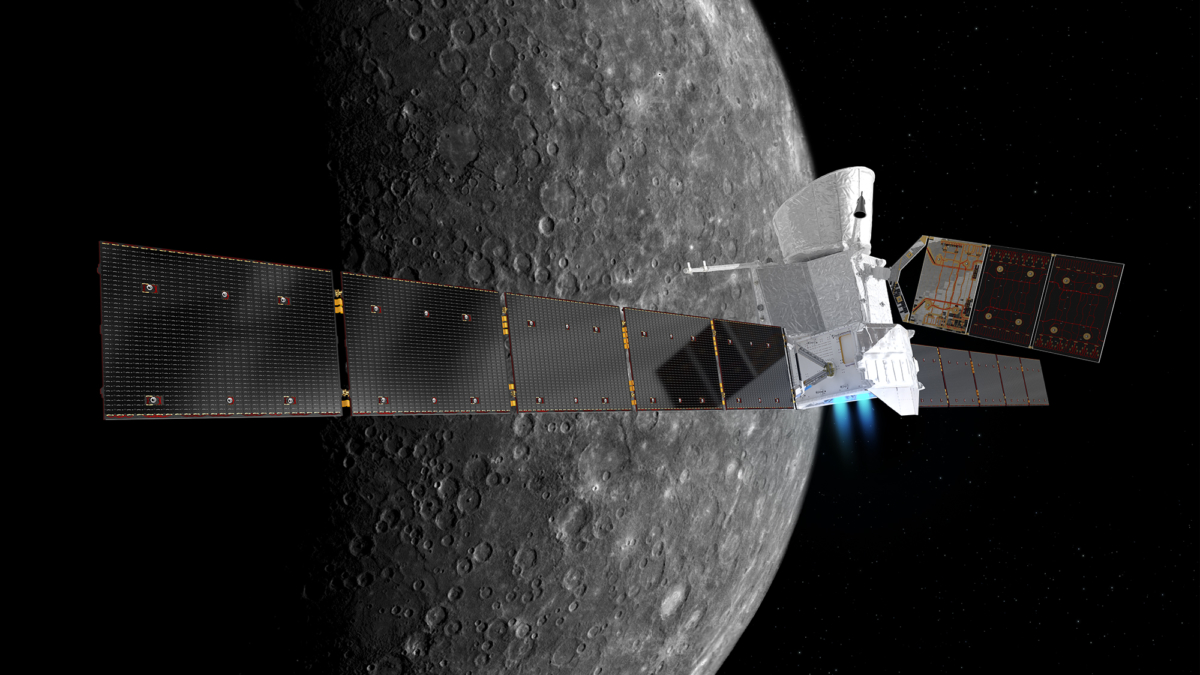
Artist’s impression of the BepiColombo spacecraft in cruise configuration, with Mercury in the background. The Mercury Transfer Module is shown with ion thrusters firing, and with its solar wings extended. The solar array of the Mercury Planetary Orbiter in the middle is seen extending to the top. The Mercury Magnetospheric Orbiter is hidden inside the sunshield in this orientation.
Credit: ESA/ATG medialab; Mercury: NASA/JPL
The European Space Agency’s BepiColombo mission to Mercury is scheduled to launch aboard an Ariane 5 from Europe’s Spaceport in Kourou, French Guiana on October 20.
BepiColombo is a joint endeavor between ESA and the Japan Aerospace Exploration Agency, JAXA. It’s an ambitious seven-year flight as the mission will make one flyby of Earth, two at Venus, and six at Mercury, before entering orbit.
Two orbiters
The mission comprises two science orbiters: ESA’s Mercury Planetary Orbiter (MPO, or ‘Bepi’) and JAXA’s Mercury Magnetospheric Orbiter (MMO, or ‘Mio’). Once at Mercury, the two orbiters will operate from different orbits to provide the most detailed study of the innermost planet date, from its interior to surface features, to its interaction with the solar wind.
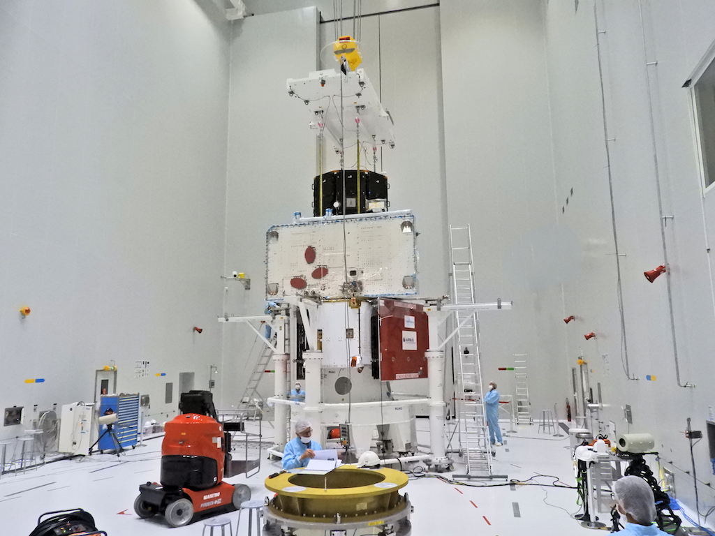
The BepiColombo spacecraft ‘stack’ is complete. ESA’s Mercury Transfer Module sits at the bottom, its two arrays folded for launch. It will use a combination of solar electric propulsion, chemical propulsion, and nine gravity assist flybys over seven years to deliver the two science orbiters to Mercury. On top is JAXA’s eight-sided Mercury Magnetospheric Orbiter. The sunshield that will protect the module during the cruise phase will be added about a week before launch.
Credit: ESA–B.Guillaume
The ESA-built Mercury Transfer Module (MTM) will carry the orbiters to Mercury using a combination of solar electric propulsion and gravity assist flybys.
Cruise phase science
BepiColombo is the first European mission to Mercury, the smallest and least explored planet in the inner Solar System.
The orbiters will be able to operate some of their instruments during the cruise phase, affording unique opportunities to collect scientifically valuable data at Venus, for example.
BepiColombo builds upon the discoveries and questions raised by NASA’s Messenger mission, which orbited the planet between 2011 and 2015, to provide the best understanding of the Solar System’s innermost planet to date.
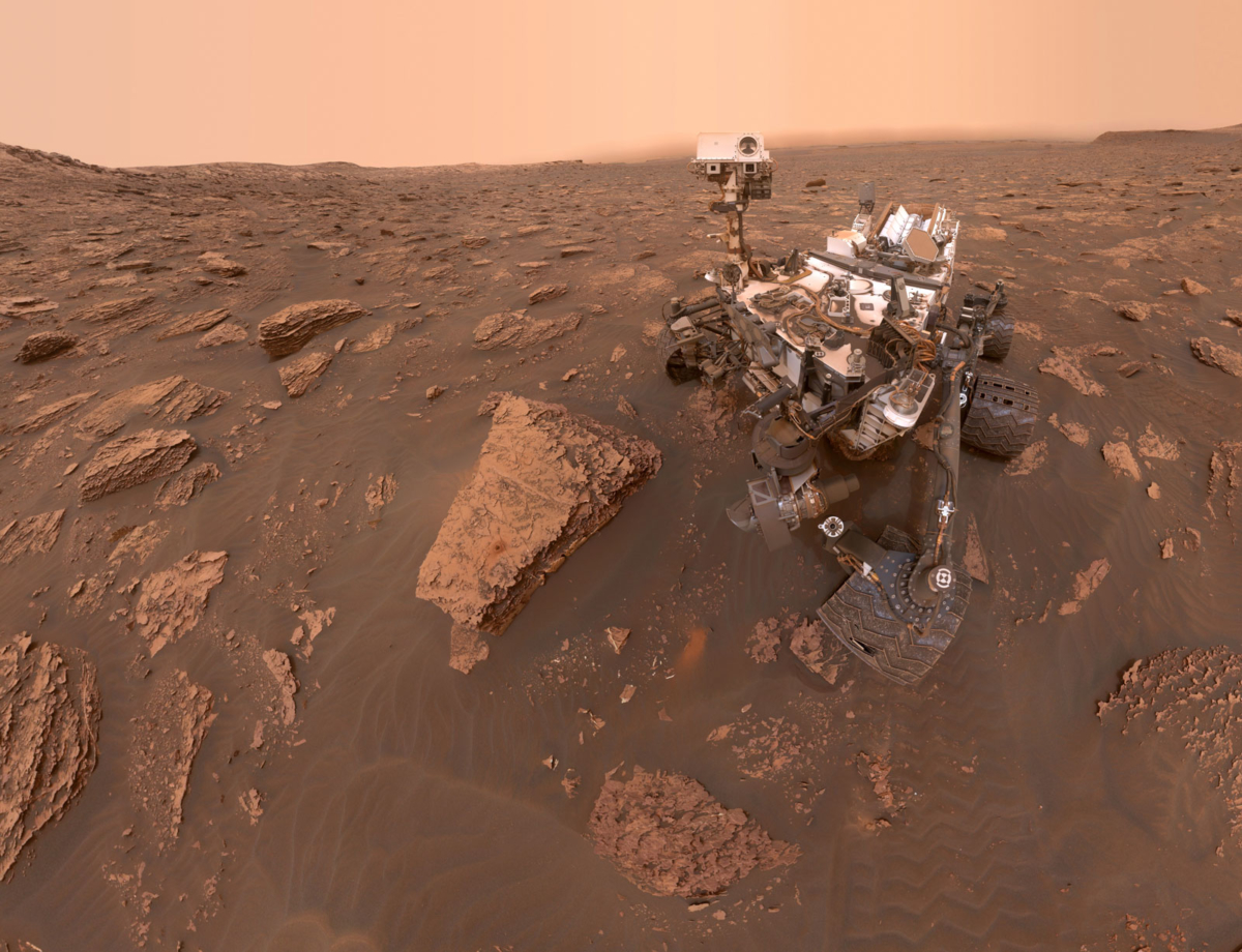
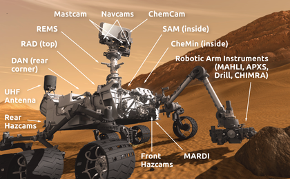
Curiosity Mars rover – on the prowl since August 2012.
Credit: NASA/JPL-Caltech/MSSS
NASA’s Curiosity Mars rover is now in Sol 2193.
The last images from the Mars machinery reached Earth back on Sol 2172, September 15th.
Engineers continue to wrestle with a glitch that prevents Curiosity from sending science and engineering data stored in its memory.
According to the Jet Propulsion Laboratory, the robot remains in its normal mode “and is otherwise healthy and responsive,” reported Ashwin Vasavada, the Mars Science Laboratory’s project scientist at JPL back on September 19th.
Geological crime scene
Meanwhile, in a new geological update from Susanne Schwenzer, a planetary geologist at The Open University in the United Kingdom: “Geology…it’s like investigating a crime scene.”
“Sometimes planetary geology is like forensics,” Schwenzer says. “We are presented with a crime scene: Something broke down the original igneous rock, and made all those clays, veins and hematite nodules. We know this something was a fluid, but in order to find out exactly what has happened, we need to examine all the evidence we have.”
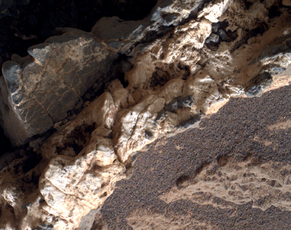
This view from the Mars Hand Lens Imager (MAHLI) on the arm of NASA’s Curiosity Mars rover shows a combination of dark and light material within a mineral vein at a site called “Garden City” on lower Mount Sharp. The image was taken on April 4, 2015, and covers an area roughly 1 inch wide.
Credit: NASA/JPL-Caltech/MSSS
That often starts with investigating the Curiosity images, and in great detail. Mastcam images for the geologic context, then Remote Micro Imager (RMI) photos and/or the Mars Hand Lens Imager (MAHLI) for the close-up details. But what about the chemistry?
Minerals with water
“We are a small team here in the UK, specializing in what is called “thermochemical modelling.” Thermochemical modelling uses mathematical equations that are based on known reactions of minerals with water,” Schwenzer explains. “The models combine many thousands of such reactions into equations, which can be solved iteratively to arrive at a reaction path for a known rock composition. And once we determine what reacted and how, we can also infer which chemical elements remained in the water because they were not included in the reaction products.”
In other words, Schwenzer adds, scientists can find out how the chemical elements are distributed between the fluid and the newly forming minerals. “Some of our French and American colleagues use this method too, and we always have great discussions to advance our work.”
Clays and veins
All the data — images and chemistry from Chemistry and Camera (ChemCam) and the Alpha Particle X-Ray Spectrometer (APXS) – is studied, and where available also mineralogy from the rover’s Chemistry & Mineralogy X-Ray Diffraction/X-Ray Fluorescence Instrument (CheMin).
“That’s the evidence at our crime scene,” Schwenzer adds. “But who broke the rock and left all those clays and white veins?”
We know it is “the fluid,” and the modelling allows us to find out what temperature and composition this fluid might have had, Schwenzer points out. “For example, we have looked at the veins Curiosity found very early in the mission – at Yellowknife Bay. They were very pure calcium-sulfate, especially compared to what Curiosity measured later at Garden City and now at Vera Rubin Ridge.”
Credit: NASA/JPL
A clue
The purity of the calcium-sulfate at Yellowknife Bay provided a clue:
“If we model a typical Yellowknife Bay rock with all chemical elements in the proportions available in this rock to react with water, then we will get veins that have more than just calcium-sulfate. We would therefore expect veins that have other minerals such as iron oxides and quartz,” Schwenzer reports.
But the veins at Yellowknife Bay did not have any of those additional minerals.
“Therefore, we concluded that they must have come from water selectively dissolving a pre-existing mixed-mineralogy layer,” Schwenzer says. “The dissolution of this pre-existing layer would have left the less soluble minerals – quartz, iron oxides – behind while transporting the calcium and sulfate. This would have allowed the formation of a very pure calcium-sulfate, which is what was observed! But how does that help us at Vera Rubin Ridge?”
Ongoing investigation
Curiosity is positioned now to investigate a very complex area, which has clearly seen the interaction of rocks with fluids.
“There are veins much more complex than the ones at Yellowknife Bay, and in addition there are iron nodules, crystal moulds and color changes,” Schwenzer notes. “We, the modellers, are working hard to understand how the fluid changed to produce all this new evidence… more later, as investigators rarely talk about ongoing investigations, right?”

Credit: 30th Space Wing
A SpaceX Falcon 9 rocket carrying the SAOCOM 1A satellite from California’s Vandenberg Air Force Base’s Space Launch Complex-4 is scheduled for Sunday, Oct. 7, at 7:21 p.m. Pacific Daylight Time.
SpaceX is attempting the secondary mission of landing the first stage of the Falcon 9 rocket at Landing Zone 4, which was previously called SLC-4W, at Vandenberg Air Force Base. This will be SpaceX’s first land landing attempt at Vandenberg Air Force Base.
SAOCOM 1A satellite
Credit: CONAE
SAOCOM (Satélite Argentino de Observación COn Microondas) is a spacecraft of the Argentine Space Agency, CONAE. This Argentine Microwaves Observation Satellite is the first of a planned Earth observation satellite constellation.
Boom town
As for the Falcon 9 booster stage come back at Landing Zone 4:
“Local residents may see the first stage of the Falcon 9 returning to Vandenberg AFB, including multiple engine burns associated with the landing,” according to 30th Space Wing Public Affairs.

Credit: 30th Space Wing
“During the landing attempt residents from Santa Barbara, Ventura and San Luis Obispo counties may hear one or more sonic booms. A sonic boom is the sound associated with the shock waves from an aircraft or vehicle traveling faster than the speed of sound. Sonic booms generate a sound similar to an explosion or a clap of thunder. The sonic boom experienced will depend on weather conditions and other factors.”
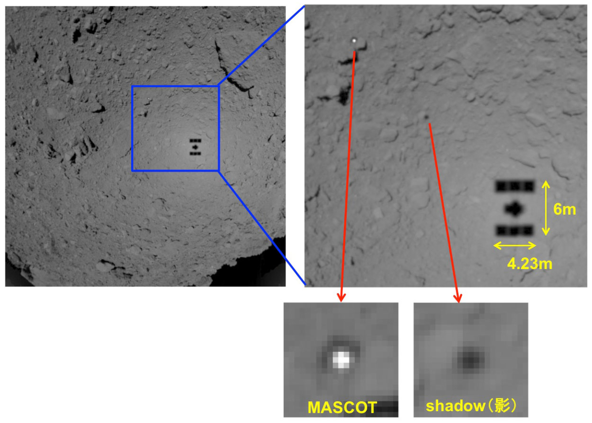
Image of MASCOT photographed with the optical navigation camera (ONC-W1), taken 2 minutes and 20 seconds after the lander separated from the spacecraft. The ONC-W1 is attached to the bottom of the spacecraft, so the view is directly below Hayabusa2. At this point, the spacecraft is rising slowly. MASCOT is the white dot and has not yet landed on the asteroid surface, so the lander casts a shadow that creates a black dot on the surface of Ryugu. Beside it is the shadow of Hayabusa2. If you enlarge the white dot of MASCOT it appears as if there is a white round dot inside a black square. It seems that it is the base (bottom) of MASCOT that is visible. The shining white dot is thought to be the antenna.
Credit: JAXA, University of Tokyo & collaborators
Japan’s Hayabusa2 successfully deployed the Mobile Asteroid Surface Scout (MASCOT), a lander developed in Germany and France.
The small asteroid lander separated from the Hayabusa2 spacecraft on October 3 and safely touched down on the surface of asteroid Ryugu. MASCOT operated for about 17 hours.
Caught on camera
After landing, MASCOT acquired scientific data on the asteroid surface, which was transmitted to the MASCOT team via the spacecraft for analysis.

MASCOT en route to asteroid’s surface photographed by an optical navigation camera onboard the Hayabusa2 spacecraft. The ONC-W2 is a camera attached to the side of the spacecraft and is shooting diagonally downward from Hayabusa2. MASCOT appears in the upper edge of the image.
Credit: JAXA, University of Tokyo & collaborators
From the Hayabusa2 spacecraft, the separated MASCOT was caught by two optical navigation cameras (ONC-W1, ONC-W2).
MASCOT came to rest on the surface approximately 20 minutes after the separation. MASCOT was ejected at an altitude of roughly 167 feet (51 meters) and descended in free fall – slower than an earthly pedestrian – to its space rock destination.
Swing arm
Upon landing, MASCOT relocated itself using a built-in swing arm. All instruments collected detailed data on the composition and nature of the asteroid. The on-board camera provided pictures of the landing, hopping maneuvers and various locations on the asteroid’s surface.
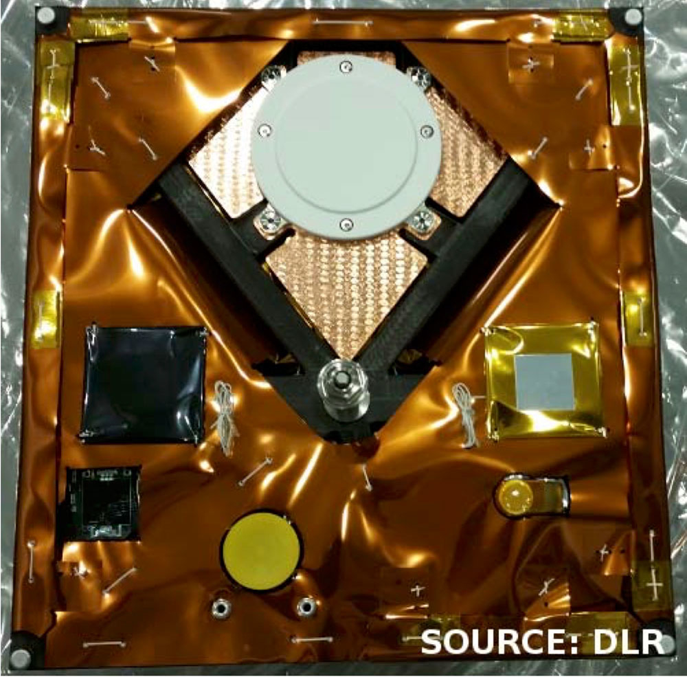
Underside base surface of MASCOT lander. The round white circle is the antenna.
Credit: DLR
MASCOT moved several meters to the next measuring point. Finally, and seeing that the lander still had battery power left, operators made a bigger jump.
Silent inhabitant
All in all, MASCOT explored Ryugu for three asteroid days and two asteroid nights. A day-night cycle on Ryugu lasts about 7 hours and 36 minutes. Three hops in three asteroid days – MASCOT successfully completed the exploration of the surface of asteroid Ryugu.
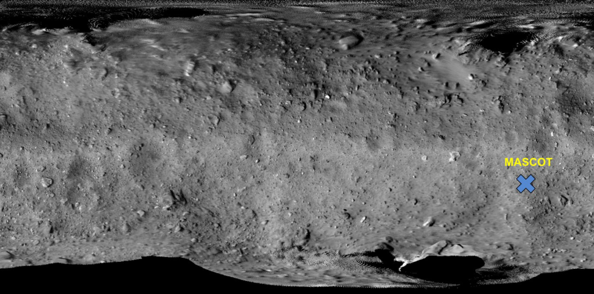
Estimated MASCOT landing point indicated on the Ryugu image taken from the home position of the Hayabusa2 spacecraft.
Credit: JAXA, University of Tokyo & collaborators
MASCOT is now a silent inhabitant of Ryugu. “The evaluation of the valuable data has just begun,” says MASCOT project manager Tra-Mi Ho from the DLR Institute of Space Systems.
Hayabusa2 is a Japan Aerospace Exploration Agency (JAXA) mission to the near-Earth asteroid Ryugu.
The German-French lander MASCOT was developed by the German Aerospace Center (Deutsches Zentrum für Luft- und Raumfahrt; DLR) and built in close cooperation with the French space agency CNES (Centre National d’Etudes Spatiales).

Credit: Obayashi Corporation of Tokyo, Japan
A novel trial-run to help design a space elevator is now at the International Space Station, tucked away within Japan’s HTV-7 resupply ship that berthed to the ISS on September 27.
The Japanese STARS-Me (Space Tethered Autonomous Robotic Satellite-Mini Elevator) was produced by researchers at Shizuoka University in Japan. Obayashi, a Japanese construction firm, is collaborating on the project.
While STARS-Me is an important experiment, the emplacing of an Earth-to-space elevator remains a “miles to go” task. Two critical problems stand in the way of a space elevator, but there are approaches to each problem
Meanwhile, there’s a plan is to create a permanent tether system on the Moon that is reusable, replaceable and expandable.
For more information on where things stand on elevating the status of the space elevator, go to my new Space.com story at:
Going Up? Waiting for the Space Elevator
By Leonard David, Space.com’s Space Insider Columnist
October 5, 2018 05:03pm ET
https://www.space.com/42041-space-elevator-test-stars-me.html
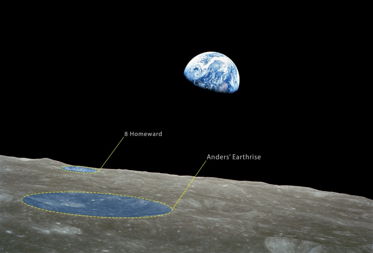
The newly named craters are visible in the foreground of the iconic Earthrise color photograph taken by astronaut William Anders. It depicts the moment that the shiny blue Earth came back into view as the spacecraft emerged out of the dark from behind the grey and barren Moon. This is arguably the most famous picture taken by Apollo 8. It became iconic and has been credited with starting the environmental movement.
Credit: NASA/IAU
That crater-pocked Moon has two new geological features: Anders’ Earthrise and 8 Homeward.
The Working Group for Planetary System Nomenclature of the International Astronomical Union has today officially approved the naming of two craters on the Moon to commemorate the 50th anniversary of the Apollo 8 mission.
Since the Moon is tidally locked to the Earth — it always has the same side facing the Earth — the Earth will never appear to rise above the surface to someone standing on the lunar far side.
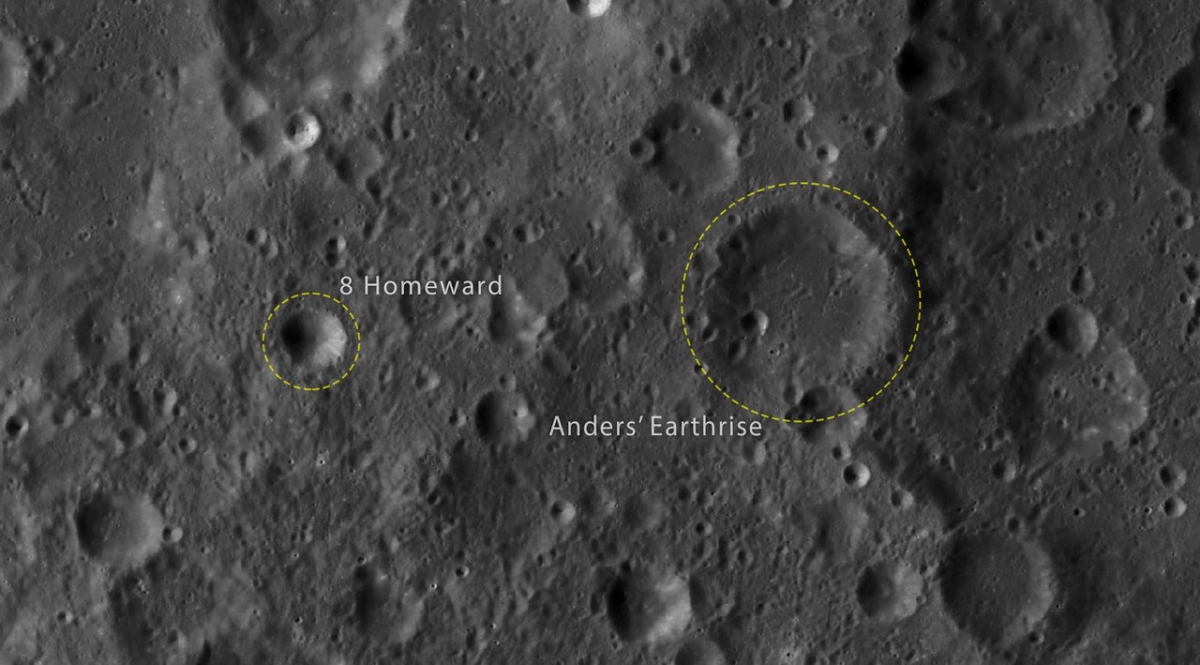
The Working Group for Planetary System Nomenclature of the International Astronomical Union has officially approved the naming of two craters on the Moon to commemorate the 50th anniversary of the Apollo 8 mission. The names are Anders’ Earthrise and 8 Homeward. These two craters are marked here.
Credit: IAU
Orbiting around the Moon, however, gave the Apollo 8 astronauts, Frank Borman, James Lovell, and William Anders a stunning view, before they safely returned home to Earth.
The Apollo 8 mission took place from 21 to 27 December 1968.
After completing 10 orbits around the Moon on Christmas Eve, broadcasting images back to Earth and giving live television transmissions, the crew returned to Earth and landed in the Pacific Ocean.
Overview of all landing sites considered in new study.
Credit: E.J. Allender et al./Advances in Space Research
An international team of lunar researchers has blueprinted an exploration scenario for humans and robots to investigate five sites on the Moon. The detailed plan for human lunar surface missions is shaped by science, strategies for surface campaigns, and a Mars-forward perspective.
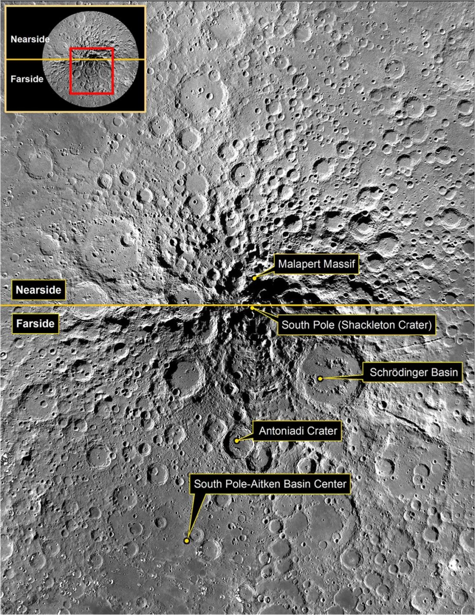
The proposed missions focus on the Moon’s south polar region and target five sites of diverse scientific interest: Malapert massif, the South Pole/Shackleton crater, Schrödinger Basin, Antoniadi crater, and South Pole-Aitken (SPA) basin.
This study is tied to release of the 2018 Global Exploration Roadmap (GER) developed by the International Space Exploration Coordination Group (ISECG). The focus of the study is how best to explore the south polar region of the Moon, a region that has not been visited by any human missions, yet exhibits a multitude of scientifically important locations – the investigation of which will address long standing questions in lunar research.
Selected sites would be visited in sequential years by crew, beginning in 2028. Two Lunar Electric Rovers are proposed to be tele-robotically operated between sites to rendezvous with crew at the time of the next landing.
The study – “Traverses for the ISECG-GER design reference mission for humans on the lunar surface” – is available online in the journal, Advances in Space Research.

Example of a landing site traverse: This image depicts Malapert massif to South Pole-Aitken basin center.
Credit: E.J. Allender et al./Advances in Space Research
Lunar goals
By visiting the proposed sites, the paper suggests that a suite of lunar investigative goals can be approached:
- The bombardment history of the inner solar system is uniquely revealed on the Moon.
- The structure and composition of the lunar interior provide fundamental information on the evolution of a differentiated planetary body.
- Key planetary processes are manifested in the diversity of lunar crustal rocks.
- Lunar volatiles increase our understanding of the composition state and distribution of volatiles in the lunar polar regions.
- Lunar volcanism provides a window into the thermal and compositional evolution of the Moon.
- The Moon is an accessible laboratory for studying the impact process on planetary scales.
- The Moon is a natural laboratory for regolith processes and weathering on anhydrous airless bodies.
- Processes involved with the atmosphere and dust environment of the Moon are accessible for scientific study while the environment remains in a pristine state.
Site selections
The South Pole-Aitken (SPA) basin is the largest and oldest recognized impact structure in the Solar System.
Malapert massif is a mountainous surface feature located on the lunar nearside. It also contains various small-scale permanently shadowed regions (PSR) which are accessible for exploration and will provide information about extreme conditions in lunar polar environment and volatile composition.
PSRs are ‘cold trap’ areas whose temperatures are cold enough to host water, carbon dioxide, and other volatiles.
Shackleton crater is at the South Pole and is a PSR that may contain icy deposits of volatiles suitable for in situ resource utilization (ISRU).
Schrödinger Basin is inside the SPA basin and formed at the end of the basin-forming epoch on the Moon. It is the best preserved basin of its size in the Earth-Moon system. Moreover, this basin contains pyroclastic material with a localized source vent making it a high-priority ISRU location.
The landing site within Antoniadi crater is noteworthy because it contains the lowest point on the Moon. Antoniadi crater contains both a central peak and a central peak ring structure and is, thus, sometimes classified as a “proto-basin.”
Oblique view of Schrödinger Basin exploration zone.
Credit: E.J. Allender et al./Advances in Space Research
Launches one year apart
The findings of the study, obtained through integration of multiple remotely-sensed lunar datasets, robotic asset capabilities, and communications feasibility, show that a human-assisted robotic mission to the lunar south polar region, including farside locations, can address key lunar science concepts, and would be a valuable resource for the early history and evolution of the Solar System.
For the study, five booster launches, one year apart, is assumed with each launch delivering a team of four crew to eDSH for subsequent surface exploration. The eDSH is a prototype habitat that builds on the expertise, capabilities, and lessons learned from the International Space Station. The plan is enabled by use of the Lunar Orbital Platform-Gateway (LOP-G).
Two Small Pressurized Rovers would be used to explore the lunar surface. Their design is assumed to be a flight-evolved version of the Lunar Electric Rover (LER) that has been field tested here on Earth in 3-day, 14-day, and 28-daylong mission simulations.
This paper led by Elyse J. Allender of the School of Earth and Environmental Sciences, University of St Andrews, St Andrews, UK – “Traverses for the ISECG-GER design reference mission for humans on the lunar surface” – can be found here:
https://www.sciencedirect.com/science/article/pii/S0273117718306604?via%3Dihub
Drop zone for MASCOT
Credit: JAXA, University of Tokyo & Collaborators
The Japan Aerospace Exploration Agency’s Hayabusa2 space probe is slated to deploy on October 3 the asteroid lander, the Mobile Asteroid Surface Scout (MASCOT).
Upon landing on asteroid Ryugu, MASCOT will only be reachable during a few time windows. Sending a command to the lander and receiving a response back on Earth will take more than 30 minutes.
MASCOT will thus be left largely to its own devices during the 16-hour-long measurement operation planned on the space rock’s surface.
Deployment time from Hayabusa2 is early in the morning, at 03:58:15 CEST.
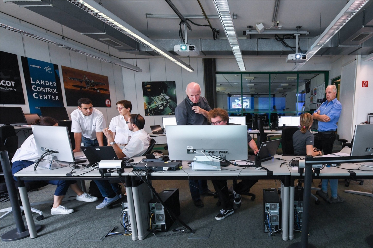
MASCOT control center
Credit: DLR (CC-BY 3.0)
Into the unknown
From MASCOT’s first moment of contact with the surface, this will be a journey into the unknown. The lander could come to rest almost anywhere within a radius of roughly 700 feet (200 meters) from the point of touchdown, after bouncing a few times.
It is planned that MASCOT will land in the southern hemisphere of the Ryugu asteroid. This location has a favorable day and night cycle and a temperature range neither too hot nor too cold for the lander. The rocks around the landing site are not too big, but there are numerous boulders measuring up to 100 feet (30 meters) in height, which present an additional challenge.
Lander control is at the German Aerospace Center (Deutsches Zentrum für Luft- und Raumfahrt; DLR) in Cologne. They will be expecting confirmation of the landing.
Landing concerns
At that time, MASCOT will have come to rest and will start taking comprehensive scientific measurements. The lander will remain there for about 16 hours before craft’s battery runs out.
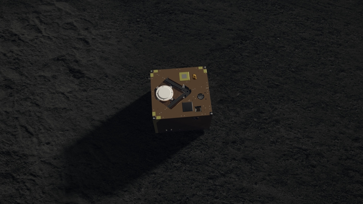
Artwork depicts MASCOT on asteroid surface.
Credit: DLR (CC-BY 3.0)
“We do not know in which direction and for how long MASCOT will bounce around after the initial touchdown, and we are of course hoping that it will not end up on terrain that is too soft or get stuck in a crevice, where it could not straighten itself,” explains DLR’s MASCOT Operations Manager Christian Krause.
“However, we are optimistic because we ran through numerous scenarios on the ground and have sent the corresponding command sequences to MASCOT,” said Krause in a press statement.
Want to follow?
The DLR Institute of Space Systems in Bremen was responsible for developing and testing the lander together with the French space agency, CNES.
Here’s an informative and good luck MASCOT video:
https://www.youtube.com/watch?time_continue=68&v=q4oenCRPFZA
Want to follow? Go to:
The Twitter account @MASCOT2018 will be posting the very latest information before and during the landing using the hashtag #asteroidlanding
Go to live feed on deployment day at:

Last image from Opportunity. Panoramic Camera photo taken on Sol 5111, June 10, 2018.
Credit: NASA/JPL/CALTECH
Due to a massive dust storm on the Red Planet, NASA’s Opportunity Mars rover has remained silent for well over three months.
No signal from the robot has been heard since Sol 5111 on June 10, 2018.
It is expected that solar powered Opportunity experienced a low-power fault. Perhaps, a mission clock fault and an up-loss timer fault, as well. The dust storm on Mars continues to subside. The science team has been listening for the rover over a broad range of times using the Deep Space Network (DSN) Radio Science Receiver. In addition, commanding “sweep and beeps” throughout the daily DSN pass is another avenue to address a possible complexity with certain conditions within the mission clock fault.
Memory issue
Meanwhile, now over two weeks ago, NASA’s nuclear powered Curiosity Mars rover also experienced a problem. Its last images were transmitted back on September 15, 2018.

One of last images from Curiosity Mars rover, taken by Front Hazcam Right B on September 15, 2018.
Credit: NASA/JPL-Caltech
In this case a memory storage issue preventing the robot from sending science and engineering data, although the Jet Propulsion Laboratory has stated that the rover remains in its normal mode and is otherwise healthy and responsive.
Engineers continue to better analyze the issue. Because the amount of data coming down to Earth from Curiosity is limited, it may take some time for the engineering team to diagnose the problem.

Mobile Asteroid Surface Scout is set for deployment from Japan’s Hayabusa2.
Credit: DLR (CC-BY 3.0)
The Japan Aerospace Exploration Agency’s (JAXA) Hayabusa2 asteroid probe is set to deploy on October 3 the MASCOT (Mobile Asteroid Surface Scout). MASCOT will join two previously deployed devices; the MINERVA-II1 consists of two rovers, 1A and 1B.
MASCOT is a mobile box-shaped landing device measuring 30 x 30 x 20 centimeters and weighing approximately 22 pounds (10 kilograms). The lander was built by the German Aerospace Center (Deutsches Zentrum für Luft-und Raumfahrt; DLR) in collaboration with the French space agency, CNES.
The lander accommodates four scientific instruments designed to study the surface of the asteroid Ryugu in detail.
Swing-arm

Christian Grimm of DLR’s Institute of Space Systems in the Department of Exploration Systems works with colleagues on MASCOT.
Credit: DLR
MASCOT includes a mechanism that enables movement on the asteroid surface – a swing-arm, made out of tungsten, which is accelerated and decelerated by a motor. That action causes the whole system to swing, so that MASCOT can move by ‘jumping’ and thus maneuver itself into the position required to conduct experiments.
MASCOT’s battery is sufficient for 16 hours of operating time. However, the actual operating time depends on the temperature and actual power consumption on site. During this time, Ryugu will go through about two full asteroid day-and-night cycles.

Pre-launch photo of MASCOT being placed on Japan’s Hayabusa2 asteroid probe.
Credit: DLR
Free-fall
MASCOT will be let loose by Hayabusa2, pushed out of its holding device by means of a spring mechanism behind a push-off plate.
The lander will free-fall from a height of roughly 200 feet (60 meters), at the falling speed of a sheet of paper, touching down on Ryugu after approximately 15 minutes. The hardware is expected to bounce at least once or several times over the surface. The final landing site and orientation are therefore uncertain.
In order to carry out the experiments, an ‘upright’ position is required: In order for MASCOT to be able to work, the on-board computer is informed of the orientation data by means of position sensors. The swing arm is then activated, making MASCOT change position if necessary, ensuring that it is in the correct position.

As Japan’s Hayabusa2 descended towards Ryugu to deploy the MINERVA-II1 rovers, a camera onboard the asteroid explorer snapped the highest resolution image yet of the space rock’s surface!
Credit: JAXA
Due to long signal propagation times to Earth, intervention from the ground station is not possible, meaning that all actions are autonomously carried out by MASCOT.
Go to this informative DLR video for more information on MASCOT:

