Archive for the ‘Space News’ Category

Chang’e-4 farside mission – lander and Yutu-2 rover
Credit: CNSA/CLEP
The lander and rover of China’s Chang’e-4 lunar farside mission have resumed operations for the 21st lunar day. A lunar day is equal to 14 days on Earth, and a lunar night is the same length.

China’s farside rover images Chang’e-4 lander in the distance.
Credit: CNSA/CLEP
Chinese news groups note that the lander woke up at 14:54 Thursday (Beijing Time) while the rover awoke at 20:34 Wednesday. Both are in normal working order, according to the Lunar Exploration and Space Program Center of the China National Space Administration (CNSA).
The Chang’e-4 mission was launched on December 8, 2018. It made the first-ever soft landing on the Von Kármán crater in the South Pole-Aitken Basin on the farside of the Moon on January 3, 2019.
The Yutu-2 rover will continue to move northwest toward the basalt area or the impact craters with high reflectivity, according to the center.

China’s Chang’e-5 robotic sample return mission.
Credit: CNSA/CLEP
Ambitious venture
If all goes according to plan, China is preparing the Chang’e-5 lunar mission by year’s end. This ambitious venture is focused on collecting and returning lunar specimens back to Earth by robotic means – a task last done in 1976 by the former Soviet Union.

Soviet Union’s last Moon sample mission, Luna 24 sits on the edge of a 60 meter diameter crater. Photo taken by NASA’s
Lunar Reconnaissance Orbiter Camera, or LROC.
Credit: NASA/GSFC/Arizona State University
The former Soviet Union successfully executed three robotic sample return missions: Luna 16 returned a small sample (101 grams) from Mare Fecunditatis in September of 1970; February 1972, Luna 20 returned 55 grams of soil from the Apollonius highlands region; Luna 24 retrieved 170.1 grams of lunar samples from the Moon’s Mare Crisium (Sea of Crisis) for return to Earth in August 1976.

China plans to launch the ambitious Chang’e 5 lunar sample return mission later this year. (Image credit: Used with permission: Loren Roberts/The Planetary Society at https://www.planetary.org/)
Apollo-like architecture
Reportedly, the Chinese mission will retrieve and return to Earth up to 4.4 pounds (2 kilograms) of lunar surface and subsurface samples.
The Chang’e-5 mission is comprised of four parts: the orbiter, lander, ascender, and Earth reentry module containing the lunar collectibles.
In many ways, but on a smaller scale, Chang’e-5’s step-by-step trek mirror those of the Apollo human landing program architecture– suggesting a scalable approach to planting Chinese footprints on the Moon.

Location of the Rümker region (black box). Yellow star represents the proposedChang’e-5 candidate landing sites.
Credit: Chikondi Chisenga, et. al
Landing region
The reported preferred candidate landing region for China’s Chang’e‐5 lunar sample return mission is the Rümker region, located in the northern Oceanus Procellarum. The touchdown area is geologically complex and known for its volcanic activity.
Detailed study of the Chang’e-5 landing region has narrowed down to four potential candidate landing sites within that region that would maximize the scientific return of the mission.
If successful, China would become the third nation to grab, stash, and haul back to Earth select lunar samples.

Welcome to the crowded and cluttered space skies above Earth…congested, contested, competitive, inspected, and dejected.
Orbiting riff-raff continues be a daunting problem – with a new study released on August 20 focused on space traffic management, or STM for short.
Space Traffic Management: Assessment of the Feasibility, Expected Effectiveness, and Funding Implications of a Transfer of Space Traffic Management – has been issued by the National Academy of Public Administration (NAPA).

In-orbit explosions can be related to the mixing of residual fuel that remain in tanks or fuel lines once a rocket stage or satellite is discarded in Earth orbit. The resulting explosion can destroy the object and spread its mass across numerous fragments with a wide spectrum of masses and imparted speeds.
Credit: ESA
Complex issues
“There is general agreement within the space community on actions that can address the complex underlying space traffic management issues facing the world of stakeholders deploying orbital assets. However, there are questions regarding where the responsibility for space traffic management should ultimately reside,” explains NAPA’s Teresa W. Gerton, President and Chief Executive Officer in a foreword to the report.

Chunk of junk zips by the International Space Station.
Credit: NASA
And the winner is…
The NAPA appraisal focused on four agency candidates “best suited” to take on the STM task: (1) the Office of Space Commerce (OSC), a part of National Oceanic and Atmospheric Administration (NOAA) inside the Department of Commerce (DOC); (2) Office of Commercial Space Transportation (AST), part of the Federal Aviation Administration (FAA) inside the Department of Transportation (DOT); (3) NASA; or (4) the Department of Defense (DoD).
The NAPA report utilized an evaluative criteria with an expert panel determining that the Office of Space Commerce (OSC) — a part of the National Oceanic and Atmospheric Administration (NOAA) inside the Department of Commerce – is “best suited” to perform STM tasks within the federal government.
Other agencies must continue to work collaboratively now, and in the future, to achieve a safer space domain, the NAPA study explains.

Clutter in the cosmos.
Credit: Used with permission: Melrae Pictures/Space Junk 3D
Actionable safety data
“The report contains a lot of good information about why Space Traffic Management (STM) matters, and why it is important for Congress to designate a Lead Agency for STM,” said George Nield, formerly the Associate Administrator for Commercial Space Transportation from 2008-2018. He is President of Commercial Space Technologies, LLC, which was founded to encourage, facilitate, and promote commercial space activities.
“In my opinion, the primary responsibility of the Lead Agency will be to develop a system that can provide timely and actionable safety data to all space operators,” Nield told Inside Outer Space. “The report doesn’t describe in detail how the Department of Commerce (DOC) would accomplish that, so Congress may have some questions for them along those lines.”
According to the report, Nield flags the fact that “OSC [the Office of Space Commerce] views its STM responsibilities as a data management function, rather than principally as a task of managing space traffic.” The report goes on to say that “OSC must find ways to leverage DoD [Department of Defense] data and capabilities.”

What’s up in space and what is that spacecraft doing?
Credit: Lockheed Martin
“Having access to DoD data and capabilities will certainly be helpful, but it will be crucial for DOC to collect and incorporate additional observations, and to use them to improve the quality of the products and services it provides,” Nield adds. “After all, it is important to recognize that the current DoD system no longer meets the needs of the user community in terms of completeness of the data, accuracy of the catalog, timeliness of the information, and the excessive number of false alarms.”

Credit: Net value? De-clutter concept.
Credit: ESA
Deploy fewer satellites
“I believe that space debris is a serious problem. But it is not a disaster, nor will it ever render space unusable or cascade into oblivion. Proving this is straightforward and irrefutable,” suggests Dave Finkleman, a member of the International Academy of Astronautics (IAA) Permanent Committee on Space Debris and other expert communities.
“But a community has grown that relies on debris funding. They continuously cite the Kessler Syndrome [a theoretical, self-sustaining cascading collision of space debris in low Earth orbit]. Deploying fewer satellites is the only assured approach to minimizing debris,” says Finkleman.
Mission impacts and cost
“Space traffic cannot be managed. No regulatory authority can force an operator to move his satellite, even if that operator is within its jurisdiction. Although many maneuvers consume little energy, there will be mission impacts and cost. Conjunction avoidance is notoriously and perhaps irretrievably imprecise and unreliable. The Air Force wishes not to be blamed for the consequences of the deficiencies,” Finkleman says.
Finkleman’s bottom line: “DoC does not have the skills for traffic management.”
Note: To read the full report — Space Traffic Management: Assessment of the Feasibility, Expected Effectiveness, and Funding Implications of a Transfer of Space Traffic Management — go to:
https://www.napawash.org/uploads/NAPA_OSC_Final_Report.pdf
Also, go to “The Dilemma of Space Debris,” by Dave Finkleman at:
https://www.americanscientist.org/article/the-dilemma-of-space-debris

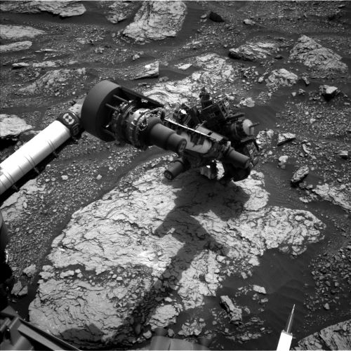
Curiosity Front Hazard Avoidance Camera Left B image taken on Sol 2861, August 23, 2020.
Credit: NASA/JPL-Caltech
NASA’s Curiosity Mars rover is now carrying out Sol 2862 tasks.
“Curiosity is still at the “Mary Anning” drill location, investigating the chemistry and sedimentary structures in this vicinity,” reports Lauren Edgar, a planetary geologist at the USGS Astrogeology Science Center in Flagstaff, Arizona.

Fossil hunter Mary Anning and faithful dog.
Courtesy: Biodiversity Heritage Library
“As we continue to dig into the science at this location, the team is having some fun with naming targets. Today the team decided to name a nearby ChemCam target ‘Tray,’ after paleontologist Mary Anning’s faithful dog who helped her with fossil hunting,” Edgar adds.

UAE’s Hope Mars orbiter.
Credit: UAE Space Agency
DSN support
It is actually the dog days of spring for Curiosity in the southern hemisphere of Mars.
A big last weekend plan involved 4 sols instead of the usual 3, due to Deep Space Network (DSN) support the Mars 2020 and Emirates Mars orbiter missions that are en route to Mars.
The first sol of a 4-sol plan — Sols 2860-2863 – was to kick off with a midday science block for Mastcam deck monitoring, a change detection observation of some nearby ripples, and a Mastcam mosaic to document local troughs and patterned ground.
Curiosity Left B Navigation Camera photo acquired on Sol 2861, August 23, 2020.
Credit: NASA/JPL-Caltech
In the evening, the rover’s Chemistry and Camera (ChemCam) was on tap to do a planned dark spectra experiment, which is a nighttime test for the CCD dark level.
Atmospheric opacity
“The second sol includes a ChemCam passive observation of the sky to assess water vapor and dust in the atmosphere, along with several other environmental monitoring activities to characterize atmospheric opacity, search for clouds, and constrain aerosol scattering,” Edgar explains.
Curiosity Chemistry & Camera Remote Micro-Imager (RMI) photo taken on Sol 2859, August 21, 2020.
Credit: NASA/JPL-Caltech/LANL
The third sol starts with a big science block, including a Mastcam multispectral observation of the second site that scientists plan to drill at Mary Anning, a few different change detection observations of ripples and troughs, ChemCam observations of bedrock targets “Tain” and “Tray,” and additional environmental observations.
Dark nodules
Also planned is use of the robot’s Mars Hand Lens Imager (MAHLI) to image some dark nodules at the target “Falkirk Wheel” and the rover’s Alpha Particle X-Ray Spectrometer (APXS) will investigate its chemistry.
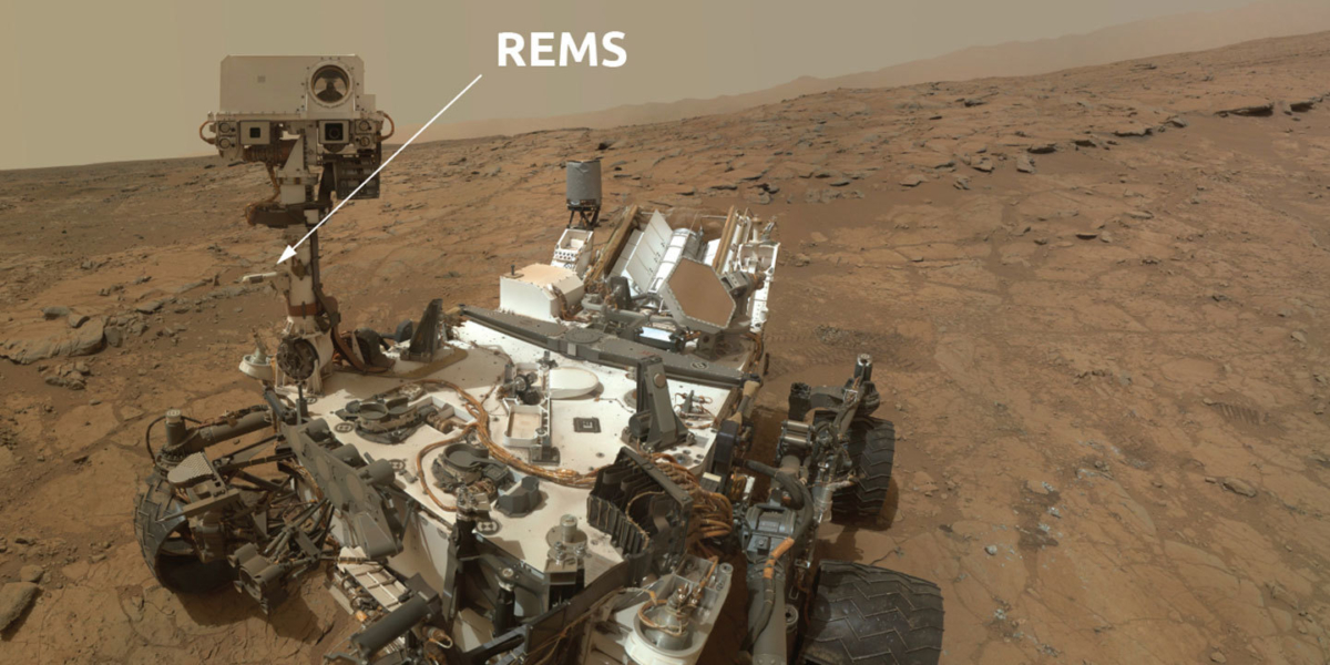
The Rover Environmental Monitoring Station is nicknamed REMS, and it contains all the weather instruments needed to provide daily and seasonal reports on meteorological conditions around the rover.
Spain’s Centro de Astrobiologia (CAB), a joint center of Consejo Superior de Investigaciones Cientificas – Instituto Nacional de Tecnica Aeroespacial (CSIC-INTA), provided a weather monitoring station contributed by the Spanish government.
Credit: NASA/JPL-Caltech
Early in the morning of Sol 2863 Curiosity will conduct more atmospheric monitoring with Mastcam and Navcam, and then most of the 4th sol will be devoted to Rover Environmental Monitoring Station (REMS) observations, Edgar reports.
Throughout the plan there are also a number of Mars Descent Imager (MARDI) change detection activities, Edgar concludes, to try to better constrain when the wind is moving sand grains around.
Credit: NASA
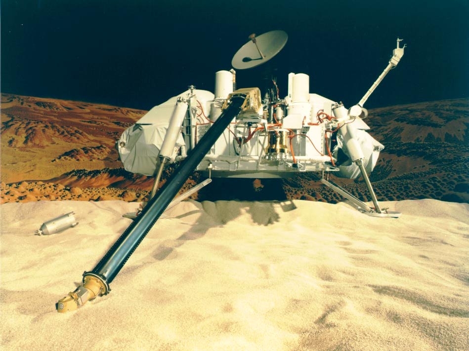
Back in 1976, the dual NASA Viking landers came to full stop on the Red Planet.
The assignment: Is there life on Mars?
Gilbert Levin was the principal investigator of the Viking Labeled Release (LR) life detection experiment and he maintains the investigation at both landing locales got positive responses.

Viking 2 Image of Mars Utopian Plain.
Credit: NASA/JPL-CalTech
That said, a consensus of scientists did not agree his results were proof of life. In 1997 Levin concluded that the experiment had, indeed, detected life on Mars – and he’s stuck to his guns ever since.
Strong evidence
In a recent issue of the American Association for the Advancement of Science (AAAS) Science Magazine, Levin once again championed his belief that the Viking LR experiment found strong evidence for extant microbial life on the Red Planet.

Gilbert Levin
Courtesy of G. Levin
Evidence
In an eLetters communiqué, tied to his review comments on a new book —The Sirens of Mars: Searching for Life on Another World — Levin assembled the following evidence supporting life on Mars:
— Amino acids and many other organics have been found all over the reachable cosmos.
— Biological fossils have been found in meteorites by many scientists.
— Liquid water, biologically complex organic compounds, all key elements of life, including CHNOPS [the six essential elements of life–carbon, hydrogen, nitrogen, oxygen, phosphorus and sulfur] have been found on Mars.
— Terrestrial microorganisms have been grown under Martian environmental conditions, and even harsher, even in naked space.
— Microbes on Earth could be impelled to Mars in bolides launched by meteoric impact, and land in viable form (all the parameters have been verified).

Credit: NASA/Ben Clark
— The Viking 1 Mission LR test and a series of increasingly decisive controls exceeded NASA’s pre-mission requirements for the detection of extant life.
— Then, as dictated by the scientific method, the Viking 1 LR repeated the test and imposed even more restrictive controls. This duplication verified the first test and its controls, thereby establishing the grounds for scientific proof.

Big Joe I at Viking landing site.
Credit: NASA/JPL
— In a separate mission, Viking 2 replicated the LR experiment and also duplicated it. All its results confirmed the presence of extant microbes.
— Viking 2 detected greenish patches on some rocks. Analyzed with the six channel Viking Imaging System, the spectrum of the patches completely matched that of terrestrial lichen when analyzed in the same system.
— Precise replicate images of the patches on the rocks taken at yearly intervals for three Martian years showed the shapes had changed, with no changes in the surrounding field, thereby eliminating wind and dust as an explanation.
NASA’s two Viking landers were designed and built by Martin Marietta (now Lockheed Martin) at its facility near Denver. This image shows some Martin Marietta employees in a Viking lander test center.
Credit: Lockheed Martin
— Chlorophyll was reported by spectral analysis of the Martian surface and on newly-appearing material on the lander deck. Although the respected scientist who made this claim withdrew the published peer-reviewed publication, coercion is suspected.
— Ultraviolet (UV) activation of the Martian surface material did not, as initially proposed by some, cause the LR reaction: a sample taken from under a UV-shielding rock was as LR-active as surface samples.
— Among complex organics reported on Mars by Curiosity’s scientists, kerogen, which is only of biological origin, was mentioned as possibly included.

NASA Phoenix Mars lander studied the Red Planet in 2008.
Credit: NASA
— Phoenix and Curiosity concluded that the ancient Martian environment was habitable. They did not conclude that it was still not so.
— The excess of carbon-13 over carbon-12 in the Martian atmosphere is strongly indicative of biological activity, which prefers ingesting the latter.
— The presence of O2 in the Martian atmosphere is also indicative of a disequilibrium, requiring constant replacement. This may be regarded as an indication of photosynthetic life as is the source of O2 on Earth.
— The seasonal cycle of O2 requires a rapid sink, which could be supplied by microorganisms.
— Methane has been measured in the Martian atmosphere both cyclically and locally; microbial methanogens could be the source.

NASA Curiosity rover on the Red Planet prowl since August 2012 and assessing the habitability of Mars.
Credit: NASA/JPL-Caltech/MSSS
— The rapid disappearance of methane from the Martian atmosphere requires a sink, possibly supplied by methanotrophs that could co-exist with methanogens on the Martian surface.
— Ghost-like moving lights, resembling will-O’-the-wisps on Earth that are formed by spontaneous ignition of methane, have been video-recorded on the Martian surface.
— Formaldehyde and ammonia, each possibly indicative of biology, are claimed to be in the Martian atmosphere.
— An independent complexity analysis of the positive LR signal identified it as biological.
— A worm-like feature was in an image taken by Curiosity.
— Large structures resembling terrestrial stromatolites (formed only by microorganisms) were found by Curiosity; a statistical analysis of their complex features showed the probability was less than 0.004 that the similarity could be caused by chance alone.

Curiosity self-portrait at “Windjana” drilling site. The Mars rover used the camera at the end of its arm in April and May 2014 to take dozens of component images combined into this space-based selfie.
Credit: NASA/JPL-Caltech/MSSS
— Images sent by Curiosity bear strong resemblances to metazoans (multiple-celled organisms) as assessed by experts.
— Images sent by Curiosity also bear features resembling mushrooms as assessed by experts. The “mushrooms” are seen to expand, and new ones pop up out of the ground in images taken several days apart.
— Nothing inimical to life, even as we know it on Earth, has been found on Mars.
Astonishing fact
In summarizing his point-by-point case for life on Mars, Levin emphasized the Viking positive result, from a test adapted from a standard test used by public health departments daily to test for microbial contamination of drinking water for billions of people in cities around the world.

Firm footing on Mars. Image taken by the first Viking Mars lander.
Credit: NASA
Those tests, Levin continued, confirmed by strong and varied controls; duplication of the LR results at each of the two Viking sites; replication of the experiment at the two Viking sites; with the above copious additional hard and circumstantial evidence for life on Mars – “and the failure for over 44 years of any experiment or theory to provide a scientifically supportable non-biological explanation of the Viking LR results.”
In a final thought, Levin asked: What is the evidence against the possibility of life on Mars?
“The astonishing fact is that there is none,” Levin concluded.

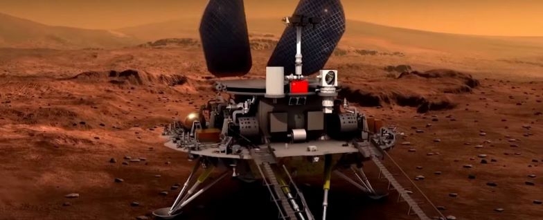
Credit: CCTV-Plus/Inside Outer Space screengrab
When China’s Tianwen-1 Mars probe settles down on the Red Planet next year, Chinese scientists will use a virtual reality system to monitor its movement on the planet.
The system can simulate the operation of the rover on Mars, including unfolding its aerials and solar array wings, climbing and changing directions.

Credit: CCTV/Inside Outer Space screengrab
“It mainly simulates the postures of the Mars rover, including its displacement, angles, information of upload and download, the rate of its signal, and temperature. We can upgrade our model according to the data we gain via remote sensing,” said Zhao Lingfeng, deputy director of the Information Center of China Academy of Space Technology in a recent China Central Television (CCTV-Plus) interview.

Credit: CCTV-Plus/Inside Outer Space screengrab
Layout of parts
The virtual reality system was also used to assemble the Tianwen-1 probe.
Chinese space engineers utilized the system to see the spacecraft’s interior design and layout of parts and to simulate the assembling process beforehand to reduce the risks during the actual assembly process.
“It can simulate various scenarios, including whether it is convenient for the workers to assemble or whether they can reach wherever they want,” Zhao said in the CCTV-plus interview. “There is a sensor inside the glasses they wear, and the sensor can locate the position of the users. For example, when he squats, he will automatically see the components in the lower parts,” said Zhao

Credit: NASA/JPL-Caltech
VR and Mars
Similar simulative systems have also been applied to other major space missions, including China’s BeiDou Navigation Satellite System and the upcoming Chang’e-5 lunar probe, expected to be launched later this year.
The use of VR and Mars is widespread. For example, when NASA scientists want to follow the path of the Curiosity rover on Mars, they can don a mixed-reality headset and virtually explore the Martian landscape.
For more information on the U.S. approach, go to:
https://youtu.be/0DvF5J6Evx4?list=PLTiv_XWHnOZqsp7on1ErHOTweF5eHzOTt
Credit: CCTV/Inside Outer Space screengrab
China’s Tianwen-1 probe en route to Mars will carry out its second orbital correction next month.
The spacecraft was launched on July 23, a probe that is a combination orbiter, lander, and rover and is due to reach the Red Planet around February 2021.
After entering Mars orbit, Tianwen-1 is slated to spend another two to three months surveying candidate landing sites before the orbiter unleashes the lander/rover.
Credit: CCTV/Inside Outer Space screengrab
The orbiter’s high definition camera will take photos of the landing zone “in order to confirm if the landing zone is the same as we expected,” Wang Chuang, chief designer of Tianwen-1, stated in a China Central Television (CCTV) interview.
Upon lander touchdown, it may take over a week for the rover to put its wheels on the Martian surface, said Jiasaid Jia Yang, deputy chief designer, Tianwen-1 Mars probe, in a recent CCTV broadcast.
Credit: CCTV/Inside Outer Space screengrab
Self-testing
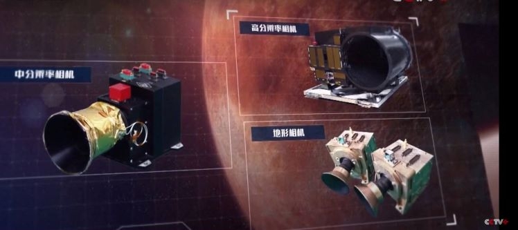
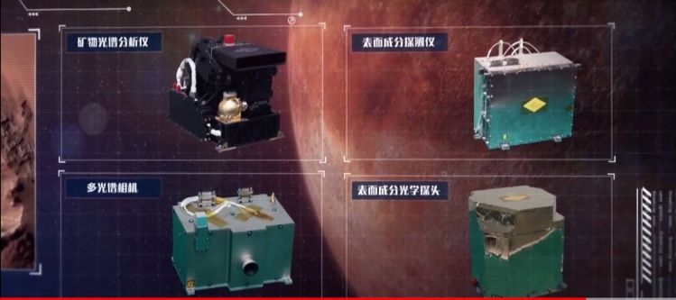
Meanwhile, according to the China National Space Administration (CNSA), Tianwen-1 completed last week self-testing of its scientific instruments, including Mars magnetometer, Mars mineralogy spectrometer and two remote-sensing cameras, which are all working in normal conditions, according to the CNSA.
Credit: CCTV/Inside Outer Space screengrab
Credit: CCTV/Inside Outer Space screengrab
According to CNSA, Tianwen-1 will perform four orbital corrections and one deep-space maneuver before reaching Mars. The probe completed its first orbital correction on August 2. The development team said it will proceed with the second orbital correction in September to ensure the probe will be flying accurately toward its target planet.
Go to this CCTV-Plus video detailing the mission at:
Credit: Ivan Vagner/Roscosmos/Inside Outer Space screengrab
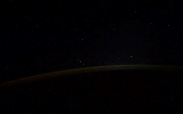
Russian cosmonaut Ivan Vagner released a video last week capturing what appears to be five objects zipping over Antarctica when the space traveler was trying to capture the southern lights from the International Space Station.
Vagner later tweeted that “the very peak of the Aurora Borealis over Antarctica is in the longitude of Australia, i.e. during the flight between them. But in the video you will see something different, not just the glow itself…at 9-12 seconds, 5 objects appear, flying in a parallel course and at the same distance from each other. What do you think it can be – meteors, satellites or…?”
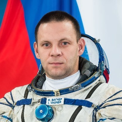
Cosmonaut Ivan Vagner.
Credit: Vagner/Roscosmos
Analysis underway
Frames were taken 1 time per second, Vagner notes, and then collected in a video of 25 frames / sec. “That is, the real time of observation of objects is 52 seconds.”
Roscosmos Flight Engineer Ivan Vagner aboard International Space Station.
Credit: NASA
Vagner adds that the information was brought to the attention of the Roscosmos State Corporation management. Materials were transferred to TsNIIMash and IKI RAS for analysis.
To view the video, go to:
https://twitter.com/i/status/1296029475164106752
Credit: Ivan Vagner/Roscosmos

Expansive plans are being blueprinted for a Moon Village, not just in the United States but in other nations as well. (Image credit: XTEND: Tomas Rousek, Katarina Eriksson, Yan Bilobrovenko, Vittorio Rossetti, Veronika Rabas, Adam Ctverak for Moon Village Association)
Permanently shadowed regions at the Moon’s poles have a story to tell. Not only could sun-shy polar ice patches yield an account about the Moon’s history, but may also offer astrobiological clues regarding the origin of life.
The floor of those craters in polar regions that have permanently shadowed floors are between 3.4 to 3.9 billion years old, based on cratering statistics.

The NASA Artemis program will send the first woman and the next man to the Moon by 2024 and develop a sustainable human presence on the Moon by 2028. The program takes its name from the twin sister of Apollo and goddess of the Moon in Greek mythology.
Credit: NASA
NASA’s Artemis program calls for landing the first woman and next man on the Moon by 2024. Also eyed is establishing sustainable exploration there by the end of the decade, fabricating an Artemis Base Camp perhaps near Shackleton Crater at the Moon’s south pole.

A South Pole landing site has not been determined, but this image shows sites of interest near permanently shadowed regions, which may contain mission enhancing volatiles. These sites may also offer long-duration access to sunlight, direct-to-Earth communication, surface slope and roughness that will be less challenging for landers and astronauts.
But how best to steer clear of contaminating these potentially ice-rich, permanently shadowed regions given human and robotic rocket landings and the growing interest in on-the-spot resource prospecting?
Go to my new Space.com story:
Cold as (lunar) ice: Protecting the moon’s polar regions from contamination – Exploration should be done thoughtfully, scientists say
https://www.space.com/moon-ice-mining-contamination-concerns.html
Clutter in the cosmos.
Credit: Used with permission: Melrae Pictures/Space Junk 3D
Year by year, as the issue of orbital trash continues to unfold, how best to deal with management of space traffic becomes problematic. But where should the responsibility of space traffic management reside?
A new study — Space Traffic Management: Assessment of the Feasibility, Expected Effectiveness, and Funding Implications of a Transfer of Space Traffic Management – has been released by the National Academy of Public Administration (NAPA).
In-orbit explosions can be related to the mixing of residual fuel that remain in tanks or fuel lines once a rocket stage or satellite is discarded in Earth orbit. The resulting explosion can destroy the object and spread its mass across numerous fragments with a wide spectrum of masses and imparted speeds.
Credit: ESA
Complex underlying issues
“There is general agreement within the space community on actions that can address the complex underlying space traffic management issues facing the world of stakeholders deploying orbital assets. However, there are questions regarding where the responsibility for space traffic management should ultimately reside,” explains NAPA’s Teresa W. Gerton, President and Chief Executive Officer in a foreword to the report.
The NAPA report provides “clear recommendations” on how Congress and the stakeholder community “should expeditiously proceed to address the looming crisis in space. Taking prompt action will serve to greatly enhance important commercial and research enterprises connected with the endless expanse that lies above us,” Gerton adds.
Chunk of junk zips by the International Space Station.
Credit: NASA
Independent review
Thanks to the appropriations act for Fiscal Year (FY) 2020 in the Senate Amendment to H.R. 1158, Division B (116th Congress) appropriations were provided to the Department of Commerce (DOC) to contract with NAPA to conduct this independent review.
As noted in the over 120-page report: “There is a consensus across industry, academia, government, and the commercial sector that Congress must appropriate adequate funding for STM [Space Traffic Management]. The expectation is that investments and costs associated with carrying out this work should reflect specific outcomes: a safer space orbit, accountability for behaviors, and less risk.”
Furthermore, the report underscores the fact that the market that supports this outcome should be enterprising, accessible, and affordable.

Dealing with debris is a cottage industry of concepts.
Credit: JAXA
Dynamic field
“Space commerce is a dynamic field,” the report stresses. “What it is today is not what it will be tomorrow and flexibilities regarding assuring appropriate funding requirements must also be fluid. The accelerated growth is at an aggressive pace as more actors enter into industry. The funding aspects for the civil agency to take a leading role in STM are just as critical.”
The NAPA appraisal focuses on four agency candidates “best suited” to take on the STM task: (1) the Office of Space Commerce (OSC), a part of National Oceanic and Atmospheric Administration (NOAA) inside the Department of Commerce (DOC); (2) Office of Commercial Space Transportation (AST), part of the Federal Aviation Administration (FAA) inside the Department of Transportation (DOT); (3) NASA; or (4) the Department of Defense (DoD).
What’s up in space and what is that spacecraft doing?
Credit: Lockheed Martin
Safer space domain
“In light of the complexities and diversity of STM tasks and functions, it is difficult to conclude in a simple manner that there is one agency to take on this function,” the NAPA review explains. “There is a clear emphasis throughout this report, based on this assessment, that these and other agencies must continue to work collaboratively now, and in the future, to achieve a safer space domain.”
All that as prelude, the NAPA report utilized an evaluative criteria with an expert panel determining that (enter drum roll here) the Office of Space Commerce (OSC) — a part of the National Oceanic and Atmospheric Administration (NOAA) inside the Department of Commerce – is “best suited” to perform STM tasks within the federal government.
Urgent call
In a recent tweet, Secretary of Commerce, Wilbur Ross, said: “The findings of the Senior Panel highlight the urgent call to action needed to ensure a safe and sustainable space environment to support a thriving U.S. and global space economy. We look forward to working with the Congress to quickly advance this critical space mission.”
To read the full report — Space Traffic Management: Assessment of the Feasibility, Expected Effectiveness, and Funding Implications of a Transfer of Space Traffic Management — go to:
https://www.napawash.org/uploads/NAPA_OSC_Final_Report.pdf
Also, go to this excellent overview of the report and its implications by Marcia Smith at SpacePolicyOnline.com at:

Curiosity Front Right Hazard Avoidance Camera image taken on Sol 2857, August 19, 2020.
Credit: NASA/JPL-Caltech
NASA’s Curiosity Mars rover is now carrying out Sol 2858 tasks.
Reports Michelle Minitti, a planetary geologist at Framework in Silver Spring, Maryland: “It was just a few short weeks ago that we acquired sample from the “Mary Anning” drill target.”
In those intervening weeks, Chemistry & Camera (ChemCam), the rover’s Chemistry & Mineralogy X-Ray Diffraction/X-Ray Fluorescence Instrument (CheMin), the Alpha Particle X-Ray Spectrometer (APXS) and the Mars Hand Lens Imager (MAHLI) “have all thoroughly investigated the resulting sample and drill hole, and found it compelling enough that we are ready to dig into the bedrock in our workspace again,” Minitti adds.

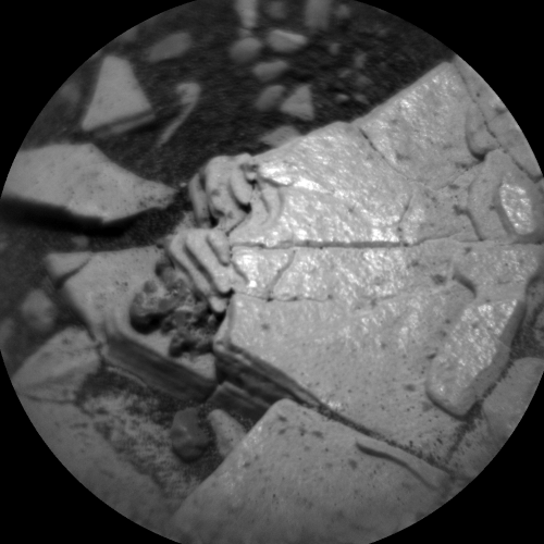
The Mars Hand Lens Imager, called MAHLI, is the rover’s version of the magnifying hand lens that geologists usually carry with them into the field. MAHLI’s close-up images reveal the minerals and textures in rock surfaces.
Credit: NASA/JPL-Caltech
Other observations
A recent plan is focused on analyzing the “Mary Anning 2” drill target, but Mars researchers had enough time to fit in other observations as well.
“MAHLI will start the fun by imaging the second Mary Anning target before the Dust Removal Tool (DRT) brushes it to hopefully better resolve the laser spots from when ChemCam shot the target on Sol 2831.

Curiosity Mars Hand Lens Imager photo produced on Sol 2857, August 19, 2020.
Credit: NASA/JPL-Caltech/MSSS
Newly-cleaned place
“After DRT brushing, MAHLI will image the target again to give APXS a look at the newly-cleaned place it will analyze,” Minitti says. “Next, the rover engineers will push the drill bit into the target to see how the rock responds ahead of drilling.”
MAHLI is slated to image the target yet again to see what kind of impression, if any, the drill bit made in the rock.
Next sample
APXS has its chance to acquire data from within the DRT-cleaned area overnight on Sol 2858.
CheMin will also be getting ready for the next Mary Anning sample by running an analysis of the empty cell that is waiting to receive the sample.
“With all this arm activity right in front of the rover, ChemCam selected a target off to rover right called “Falkirk Wheel.” Falkirk Wheel appears to be another collection of dark nodules like the “Ayton” target analyzed by ChemCam, MAHLI, and APXS in previous plans,” Minitti adds.

Curiosity Mars Hand Lens Imager photo produced on Sol 2857, August 19, 2020.
Credit: NASA/JPL-Caltech/MSSS
Disappearance of drill tailings
Comparing and contrasting these targets, Minitti continues, will hopefully help scientists understand more about their origin.
A recent MAHLI image of the first Mary Anning drill hole shows the disappearance of the drill tailings around the hole.
Minitti says that makes it abundantly clear that winds are moving material around.
Kicking up dust devils?
Also on the plan, both the robot’s Mastcam and the Mars Descent Imager (MARDI) will acquire images aimed at tracking wind-induced changes.
“Mastcam will image a patch of ripples at the “Skelmorlie” target for comparison to previous images of that area,” Minitti explains. “MARDI will image three times – twice in the early evening and once early in the morning – to figure out when the winds are at their strongest.”

The Rover Environmental Monitoring Station is nicknamed REMS, and it contains all the weather instruments needed to provide daily and seasonal reports on meteorological conditions around the rover.
Credit: NASA/JPL-Caltech
Are the winds kicking up dust devils? Navcam will acquire a movie to look for them.
Meanwhile, Curiosity’s Rover Environmental Monitoring Station (REMS), the Radiation Assessment Detector (RAD) and the Dynamic Albedo of Neutrons (DAN) dot the plan keeping their regular eyes on the state of the environment above and below the rover, Minitti concludes.

