Archive for the ‘Space News’ Category
 Author:
  August 4th, 2021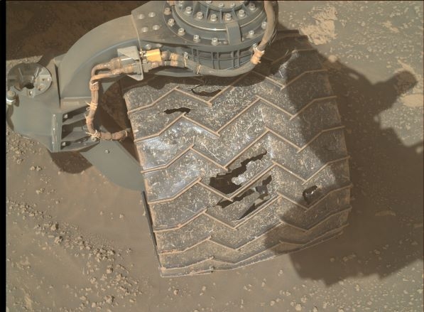
Curiosity operators have recently done full Mars Hand Lens Imager (MAHLI) wheel imaging. Image shows wheel, bedrock and some nodules.
MAHLI photo produced on Sol 3195, August 2, 2021.
Credit: NASA/JPL-Caltech/MSSS
NASA’s Curiosity Mars rover at Gale Crater has just begun performing Sol 3198 tasks.
Reports Susanne Schwenzer, a planetary geologist at The Open University; Milton Keynes, in the U.K.: A recently scripted two-sol (3197, 3198) plan focuses on what geologists call nodules, “little rounded things that stick out of the surrounding rock because they are just a little bit more resistant to weathering than the rock itself. The term nodule thereby does not say anything about how they formed; it’s just a description of what you see in the images.”
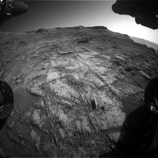
Curiosity Front Hazard Avoidance Camera Right B photo taken on Sol 3197, August 4, 2021.
Credit: NASA/JPL-Caltech
Curiosity is parked in an area that has lots of those nodules. Consequently, the robot’s Alpha Particle X-Ray Spectrometer (APXS) was set to look at target “Vendoire” in the workspace, and that target has lots of these nodules.
Fingers crossed
The Chemistry and Camera (ChemCam) instrument is also to join the effort, trying to hit some of the nodules also imaged by a Mastcam multispectral observation, “but they are tiny, so, fingers crossed,” Schwenzer adds. “Always remember, we are trying to hit something of the size of a dime or smaller at a distance from about 3 meters or more. Let’s see what target “Beleymas” brings, but we are confident to at least hit some!”
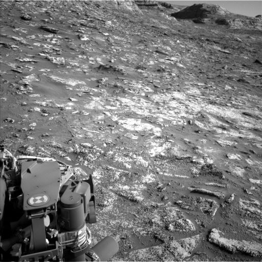
Curiosity Left B Navigation Camera image acquired on Sol 3197, August 4, 2021.
Credit: NASA/JPL-Caltech
ChemCam is also looking into the distance, where scientists have spotted an outcrop where there are changes in the textures – the upper part of the outcrop looks smoother from the rover’s vantage point than the lower part.
“What’s better than getting close by pointing the remote imager at it? That will help us decide what might be behind the patterns in the current images,” Schwenzer notes. “Mastcam is joining the distance-imaging and adding color to the ChemCam images, as well as looking right in front of the rover to support the nodule investigations and a butte in the ‘Sands of Forvie’ area. It is collecting two multispectral observations in support of the nodule observation on targets ‘Baneuil’ and the above named target ‘Beleymas.’”
Clast survey
After all this science there is a rover drive, more imaging, and more science.
“The imaging is mostly to get the data needed for the next planning, but also a little science as we are also getting an image for our regular clast survey,” Schwenzer explains.
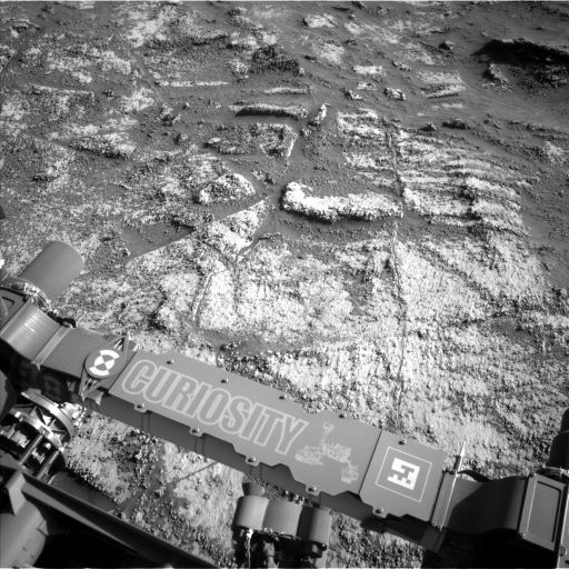
Curiosity Left B Navigation Camera image acquired on Sol 3197, August 4, 2021.
Credit: NASA/JPL-Caltech
Clast surveys are high angle monoscopic images acquired periodically of soil deposits in front of the rover.
The robot’s ChemCam will perform an Autonomous Exploration for Gathering Increased Science (AEGIS) observation, where it looks for its own target after the drive.
“Those investigations add important capabilities to our plans as they allow us to use ChemCam [Laser Induced Breakdown Spectroscopy] (LIBS) before we here on Earth have seen the new parking space,” Schwenzer concludes. “It’s an interesting area, especially for me as a mineralogist, as all those nodules usually also mean chemical and mineralogical changes. Well, we’ll soon find out!”
 Posted in
Credit: ESA
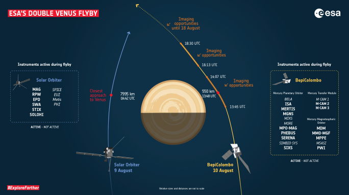
Venus is getting a once-over…no wait. Venus is getting a twice-over!
Two separate spacecraft are making dual flybys just 33 hours apart on August 9 and August 10.
The European Space Agency’s (ESA) Solar Orbiter and BepiColombo probes both need a gravitational swingby to reach their ultimate destinations
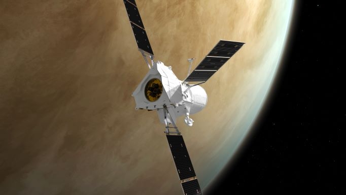
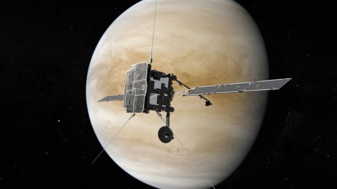
BepiColombo is on its way to Mercury; Solar Orbiter is en route to view the Sun’s poles.
BepiColombo
Credit: ESA/ATG medialab
Observations
It is not possible to take high-resolution imagery of Venus with the science cameras onboard either mission. However, two of BepiColombo’s three monitoring cameras will be taking photos around the time of close approach and in the days after as the planet fades from view. Furthermore, there may be an opportunity for Solar Orbiter’s SoloHI imager to observe the nightside of Venus in the week before closest approach.
Solar Orbiter
Credit: ESA/ATG medialab
Additionally, both Solar Orbiter and BepiColombo’s Mercury Planetary Orbiter and Mercury Magnetospheric Orbiter will collect data on the magnetic and plasma environment of Venus from different locations.
The data collected during the flybys will also provide useful inputs to ESA’s future Venus orbiter, EnVision, which was selected earlier this year and will launch to Venus in the 2030s.

China’s space station expected to be completed around 2022.
CMS/Inside Outer Space screengrab
At a quickening pace, China is blueprinting and carrying out a striking 21st space agenda, including a succession of robotic interplanetary missions to asteroids, Jupiter, and returning samples from Mars. Layered into the mix is a five year plan for Moon exploration, capped by inking a partnership with Russia to put in place an International Lunar Research Station to be visited by human crews.
In the meantime, nearer to Earth, China is presently constructing the country’s “Heavenly Palace.” A core segment of the multi-modular Tiangong space station is already up and operating, housing a three-person crew. A go-getting schedule of booster launches of more astronauts, supply ships, and add-on modules stretches into late next year to finish China’s orbital outpost. The China Manned Space Agency has reportedly given provisional approval to stuff the station with over a 1,000 experiments and is working with the United Nations to invite foreign participation.

Chinese President Xi Jinping inspects Chang’e-5 lunar sample return capsule.
Credit: CCTV/Inside Outer Space screengrab
All this activity is not going unnoticed by the United States. What impact China’s space schedule, along with the country’s joint ventures with Russia, will have on U.S. space exploration objectives is murky. Some suggest, perhaps, it’s time to search for common ground and shape a multi-nation space agenda. If so, how best to play the China space cooperation card?

China’s touchdown on Mars.
Credit: CNSA/Inside Outer Space screengrab
Take a read of my new Scientific American story on this topic at:
“Can the U.S. and China Cooperate in Space? – China’s meteoric rise in space science and exploration—along with its new partnership with Russia—is spurring U.S. experts to reconsider a long-standing prohibition on bilateral collaborations”
https://www.scientificamerican.com/article/can-the-u-s-and-china-cooperate-in-space/

Curiosity Front Hazard Avoidance Camera Right B image acquired on Sol 3193, July 30, 2021.
Credit: NASA/JPL-Caltech
NASA’s Curiosity Mars rover is now performing Sol 3194 tasks.
“Curiosity is continuing to climb through an area where orbital data show the layers of Mount Sharp are transitioning from clay-bearing to sulfate-bearing,” reports Abigail Fraeman, a planetary geologist at NASA’s Jet Propulsion Laboratory. “I continue to be dazzled by the textures we’re seeing, especially the prevalence of centimeter sized bumps and lumps poking out of the bedrock.”
Fraeman notes that the robot’s Chemistry and Camera (ChemCam) Remote Micro-Imager (RMI) has captured a particularly whimsical image of an interesting rock texture. The whole field of view is about 16.5 cm across, so this is a very tiny feature!

Curiosity Chemistry & Camera (ChemCam) Remote Micro-Imager (RMI) photo taken on Sol 3190, July 27, 2021.
Credit: NASA/JPL-Caltech/LANL
Scenic terrain
A recently scripted plan for sols 3192 and 3193 include contact science, remote sensing, and driving.

Curiosity Right B Navigation Camera image taken on Sol 3193, July 30, 2021.
Credit: NASA/JPL-Caltech
Curiosity was set to observe a nodular bedrock target named “Champeaux” with its Alpha Particle X-Ray Spectrometer (APXS) and Mars Hand Lens Imager (MAHLI) first thing in the morning on sol 3192.

Curiosity Right B Navigation Camera image taken on Sol 3193, July 30, 2021.
Credit: NASA/JPL-Caltech
Then the plan scripts capturing Mastcam and ChemCam RMI mosaics of some of the scenic terrain surrounding Curiosity, a ChemCam Laser Induced Breakdown Spectroscopy (LIBS) observation of “Manaurie,” and additional Mastcam images of surrounding outcrops.

Strategic route
“After wrapping up science at this site, we’ll drive along our strategic route up Mount Sharp and spend the second sol [3193] of the plan collecting observations that monitor the environment,” Fraeman says.

Also on tap is acquiring a ChemCam autonomously selected Autonomous Exploration for Gathering Increased Science (AEGIS) observation.

Complex terrain of rocks, impact craters and sand dunes.
Credit: CNSA
China’s Zhurong Mars rover has been operating on the Martian surface for 75 Martian days and has traveled over 2,322 feet (708 meters) within the Red Planet’s Utopia Planitia.
The robot has begun traversing “complex terrain” the China National Space Administration (CNSA) said on Friday. Rocks, impact craters and sand dunes characterize that exploration site.
The rover has completed a survey of a second sand dune and is wheeling southward. Zhurong arrived in the complex terrain area earlier this week, said the center.

China’s Zhurong Mars rover.
Credit: CCTV/Inside Outer Space screengrab
Terrain images
According to China Central Television (CCTV), ground operators will make visual positioning and movement path planning for the rover based on navigation terrain images they obtain every day, so as to ensure the rover’s safety in the area.
When Zhurong meets a target of interest, scientific payloads onboard the rover — such as the surface composition detector and multispectral camera — will carry out tasks. During the journey, the rover’s subsurface radar, meteorological measurement instrument, and subsurface detection radar will also be turned on for detection.

Credit: CCTV/Inside Outer Space screengrab
Data processing
China’s Tianwen-1 spacecraft, consisting of the orbiter and the rover as well as a lander, was launched on July 23, 2020. The lander carrying the rover touched down in the southern part of Utopia Planitia, a vast plain in the northern hemisphere of Mars, on May 15.
Zhurong drove down from its landing platform to the Martian surface on May 22, making China the second country after the United States to land and successfully operate a rover on Mars.
A newly issued CCTV video details the transmission and processing of data from Mars via China’s Tianwen-1 Mars probe mission.
Go to: https://youtu.be/FYhKBm0DjFQ

The United States government and commercial spaceflight providers have no plans in place to conduct a timely rescue of a crew from a distressed spacecraft in low Earth orbit, or anywhere else in space.
Without rescue plans in place, today’s space travelers will journey at their own risk.
The present posture, of not planning for in-space rescue and not having responsive in-space rescue capabilities, needs to be addressed before the need for a rescue materializes. The U. S. has the wherewithal to establish space rescue capabilities and to do so with a sense of urgency.
A new report — The In-space Rescue Capability Gap — seeks to raise awareness of the need to revisit space rescue policies and put in place measures to address this issue.
Author of the report, Grant Cates, is a senior project leader for The Aerospace Corporation’s Space Architecture Department.

USS Squalus and Diving Bell by John Groth/
Naval History and Heritage Command
Historical analogs
Issued by the corporation’s Center for Space Policy and Strategy and the organization’s Space Safety Institute, Cates uses historical analogs, such as the ancient maritime explorers that embarked upon epic journeys with multiple ships, effective submarine rescue operations, and the rich history of human spaceflight.
Potential solutions to improve safety during space travel are identified and policy options are discussed in the paper.
The paper offers a series of conclusions:
- The United States has no present capability or policy for conducting in-space rescues. This despite:
- Having studied space escape and rescue systems since 1959.
- Having demonstrated a self-rescue capability during the aborted Apollo 13 mission.
- Having put in place rescue capabilities for the Skylab mission.
- Experiencing the hard-learned revelation of the importance of in-space rescue options after the loss of space shuttle Columbia and her 7-person crew.
Columbia catastrophe
On February 1, 2003, Columbia broke up as it reentered Earth’s atmosphere, killing all onboard, with NASA suspending shuttle mission for more than two years as it looked into causes of the catastrophe.

Credit: NASA
Indeed, the report of the Columbia Accident Investigation Board concluded that if NASA had recognized the damage at the beginning of the mission, then a rescue by using the next space shuttle due for launch, Atlantis, would have been feasible.
That rescue would have entailed maneuvering Atlantis next to Columbia and then transferring the crewmembers via individual spacewalks. “This rescue was considered challenging but feasible,” as noted in the Columbia Accident Investigation board report volume 1.
First step
“A space rescue capability is likely to be highly synergistic with the long-sought-after capability of having responsive launch capability,” Cates writes. “Perhaps a good first step to achieve both would be for the U.S. Congress to establish a policy such as: “It should be the policy of the United States to develop and put in place rapid launch-on-need capability to support: timely rescue of astronauts in cis-lunar space; rapid reconstitution of nationally important space assets; and the ability to put in place new space capabilities in response to emerging threats in near real time.”

Credit: dearMoon
Imagine the public outcry, Cates adds, that could arise if an Inspiration4, Axiom, dearMoon or a similar mission were stranded in low Earth orbit or cislunar space by a disabled spacecraft.
Inspiration4 is the world’s first all-civilian mission to orbit. The mission will be commanded by Jared Isaacman, the 38-year-old founder and Chief Executive Officer of Shift4 Payments and an accomplished pilot and adventurer.
Axiom’s four-person Ax-1 crew is to fly to the International Space Station.
The dearMoon project is a lunar tourism mission and art project conceived and financed by Japanese billionaire Yusaku Maezawa.
To read the full report — The In-space Rescue Capability Gap – go to:
https://aerospace.org/sites/default/files/2021-07/Cates_SpaceRescue_20210728.pdf

After lifting off from the lunar surface, the Apollo 11 ascent stage docked with the Columbia command module, with Neil Armstrong and Buzz Aldrin rejoining Mike Collins. The ascent stage was then jettisoned in lunar orbit.
Credit: NASA
New research points to the prospect that the historic Apollo 11 “Eagle” Lunar Module ascent stage may still be orbiting the Moon.
James Meador has published his numerical analysis and simulations in the Planetary and Space Science journal, work that “provides evidence that this object might have remained in lunar orbit to the present day.”
Meador notes that the lunar modules were designed for 10-day missions, and little consideration was given to long-term reliability. “For this reason, fuel leaks might have resulted in propulsive events or even complete destruction at any time after the craft was jettisoned. Although catastrophic outcomes are possible, there exists some possibility that this machine might have reached an inert state, allowing it to remain in orbit to the present day. If so, it should be detectable by radar,” he writes.
Wanted: radar scans
A rough analysis indicates that the historic Eagle ascent stage that boosted Neil Armstrong and Buzz Aldrin off the Moon would be more than 78 miles (125 kilometers) above the lunar surface in about 25% of limb crossings.
“If one assumes radar is able to detect objects at this altitude, then four judiciously chosen 2-hour observation periods should provide sufficient coverage to possibly relocate one of the most important artifacts in the history of space exploration,” Meador writes.
To access the complete paper – “Long-term orbit stability of the Apollo 11 “Eagle” Lunar Module Ascent Stage” – go to:
https://www.sciencedirect.com/science/article/abs/pii/S0032063321001434
Note: Special thanks to skywatcher John Williams for calling my attention to this interesting research.

20th century French depiction of ball lightning flying through a window.
Credit: Louis Poyet/Wikimedia, Public Domain
Significant attention is now being given to Unidentified Aerial Phenomenon (UAP), recently bolstered by the Galileo Project, led by Harvard scientist Avi Loeb.
An upshot of such research is that UAP studies may foster the discovery of — or better scientific explanations for — potential new natural atmospheric phenomena.
For example, ball lightning is on the baffling phenomenon list, described as luminescent, spherical objects that vary from pea-sized to several meters in diameter. While ball lightning has been reported for centuries, this phenomenon has not been consistently observed by scientific instruments.
Eyewitness accounts
Enter a new website hosted by New Mexico Tech physicist Richard Sonnenfeld and Texas State University engineer Karl Stephan. Their goal is to collect eyewitness accounts to improve the basic understanding of the phenomenon. Reported accounts will be compared to weather radar systems to characterize the factors that may well trigger ball lightning.

Texas State University engineer Karl Stephan.
Stephan has conducted investigations of naturally occurring luminous spheroids, which include various phenomena such as ball lightning, even “earthquake lights.” Several of the researcher’s publications deal with laboratory phenomena that replicate or clarify various reported properties of ball lightning, including its degree of apparent opacity, its motion under the effects of a net charge, and its persistent glow.

Credit: Scientific Coalition for UAP Studies (SCU)
Sensor systems
“Ball lightning was an unexplained aerial phenomenon long before anyone heard of UFOs,” Stephan told Inside Outer Space. “There have been recent calls for increased scientific investigation of UAPs using all-sky cameras and sensor networks to acquire data in an organized way that would allow a systematic analysis of sighted objects.”
Stephan says the same kinds of sensor systems that would look for UAPs would also be useful for observing ball lightning, and similar kinds of data processing would be needed to filter out the explainable data (e. g. airplanes, balloons, meteorites, etc.) in order to focus on what you are looking for.
“I think a serious observational and experimental effort to explain ball lightning would take us far in the direction of explaining UAPs, with the advantage that we already have a rudimentary understanding of ball lightning, such as its association with thunderstorms,” Stephan adds.
“Perhaps if UAP research moves from the shadows of fringe science into the mainstream,” Stephan says, “the same thing can happen to ball lightning research, as similar methods are needed for both.”

FLIR
Credit: DOD/U.S. Navy/Inside Outer Space screengrab
Precise position and time information
Have You Seen Ball Lightning? If so, Sonnenfeld and Stephan are eager to hear from you.
That information would allow the scientists to answer the following questions:
1) How frequently ball lightning associated with natural lightning?
2) In cases where it is associated, how nearby does the lightning need to be?
3) Is there anything special (e.g. polarity, max current, structure, multiplicity, continuing currents) about the natural lightning or thunderstorm that is associated with ball lightning production.
Other elements of those filing reports are also of interest. In particular:
— What does the formation and destruction of the ball look like?
— Is the path consistent with hot buoyant gasses?
— Is the path consistent with a charged object inducing charge in other objects and tending to trace surfaces?
— How does the ball pass through windows? Does it ever pass through electrical conductors?
As their website explains, despite thousands of published reports of ball lightning and a scientific literature comparable in volume to the literature on conventional lightning, researchers still have no idea of what mechanisms create or power ball lightning. “Our hope with this site is to get reports that contain precise position and time information regarding ball lightning.”
Resources
Go to this website to file a ball lightning report at:
http://kestrel.nmt.edu/~rsonnenf/BL/#REPORT
Also, check out this article from the American Geophysical Union’s Eos.org: “Have You Seen Ball Lightning? Scientists Want to Know About It” at:
https://eos.org/articles/have-you-seen-ball-lightning-scientists-want-to-know-about-it

Curiosity Front Hazard Avoidance Left B Camera image taken Sol 3190, July 27, 2021.
Credit: NASA/JPL-Caltech
NASA’s Curiosity Mars rover at Gale crater is now performing Sol 3191 tasks.
Reports Michelle Minitti, a planetary geologist at Framework in Silver Spring, Maryland: “Our weekend drive completed successfully, landing us north of a roughly 15 meter [49 feet) tall butte that we had imaged the east side of over the weekend. The new parking position gave us a new angle on the butte. Seeing structures from multiple angles helps geologists unravel the story of their formation by revealing their layers in three dimensions.”

Curiosity Mast Camera Right images acquired on Sol 3188, July 25, 2021.
Credit: NASA/JPL-Caltech/MSSS
Butte imagery
A newly scripted plan offered a challenge; the large Mastcam mosaic scientists wanted to acquire of the butte was best taken early in the day, before the butte began to cover itself in its own shadow, and this window of time overlapped the best time to acquire Alpha Particle X-Ray Spectrometer (APXS) data before a drive.
“Rather than having to pit APXS against Mastcam, we were allowed to try something relatively unusual,” Minitti adds. Typically, when researchers analyze a target with APXS before a drive, they acquire Mars Hand Lens Imager (MAHLI) images of the same target immediately after APXS is done.
“Today, we broke up APXS and MAHLI, putting the desired Mastcam imaging and other remote science observations after APXS. MAHLI was then scheduled after the remote observations, but before the drive,” Minitti points out. “This allowed all the observations to occur at times that would benefit them – wins all around!”

Curiosity Front Hazard Avoidance Left B Camera image taken Sol 3190, July 27, 2021.
Credit: NASA/JPL-Caltech
Bedrock chemistry
APXS and MAHLI were to analyze a patch of relatively smooth bedrock, “Fressignas,” to systematically record bedrock chemistry as the rover climbs up Mount Sharp.
“In addition to the large butte mosaic, Mastcam acquired a small mosaic of a bedrock slab right of the rover, dubbed “Creysse,” which exhibited a combination of lineations and resistant features that added to the variety of textures we have seen over the last several weeks,” Minitti notes.
Resistant nodules
The robot’s Chemistry and Camera (ChemCam) acquired a small Remote Micro-Imager (RMI) mosaic of yet another wonderful structure, “Mescoules,” a delicate arch of rock that appeared to be made of a concentration of the resistant nodules so common in the local bedrock.
Curiosity Chemistry & Camera (ChemCam) Remote Micro-Imager (RMI) photo taken on Sol 3190, July 27, 2021.
Credit: NASA/JPL-Caltech/LANL
“ChemCam will analyze the chemistry of a linear horizon of resistant nodules at the target “Loubejac” to continue our investigation of what makes these nodules stand out from the bedrock that hosts them,” Minitti explains.
After a drive that we hope will be extended in distance by Curiosity’s autonomous navigation capabilities, ChemCam will acquire chemistry from an autonomously-selected target, and scientists will turn their attention to the atmosphere.

Curiosity Left B Navigation Camera image acquired on Sol 3190, July 27, 2021.
Credit: NASA/JPL-Caltech
Pulse of Gale crater
“APXS will acquire a measurement of argon in the Mars atmosphere, Navcam and Mastcam will measure the amount of dust in the atmosphere, and Navcam will shoot a movie in search of dust devils,” Minitti adds.
These dedicated atmospheric observations take place over a background of regular Radiation Assessment Detector (RAD), Rover Environmental Monitoring Station (REMS) and Dynamic Albedo of Neutrons (DAN) measurements that keep their finger on the pulse of the Gale crater environment,” Minitti concludes.

Curiosity’s location on Sol 3185. Distance driven to date is 16.06 miles (25.85 kilometers)
Credit: NASA/JPL-Caltech/Univ. of Arizona
NASA’s Curiosity Mars rover is now performing Sol 3188 tasks.
Ken Herkenhoff, a planetary geologist at USGS Astrogeology Science Center in Flagstaff, Arizona, reports that a Sol 3185 drive went well.
The robot is now near a low, linear ridge. “This ridge attracted the attention of the tactical science team so several observations of it are included in a 3-sol weekend plan,” Herkenhoff adds.

Following a Sol 3185 drive, the rover is near a low, linear ridge shown in the lower left part of image acquired by Curiosity’s Left Navigation Camera Sol 3185 July 22, 2021
Credit: NASA/JPL-Caltech
Weekend science
This weekend plan was slated to start with a Chemistry and Camera (ChemCam) Laser Induced Breakdown Spectroscopy (LIBS) raster on a dark, rough target named “Chalagnac” and a Mastcam 5×2 stereo mosaic of the area surrounding Chalagnac.
Mastcam was set to also take a 5×1 stereo mosaic of a nearby trough before arm activities begin.
The DRT will be used to brush dust off a bedrock target dubbed “Chauffour” and ChemCam’s Remote Micro-Imager (RMI) will be used to take pictures of the drill bit to look for changes.

Mars Hand Lens Imager photo produced on Sol 3187, July 24, 2021.
Credit: NASA/JPL-Caltech/MSSS
Herkenhoff points out that the rover’s Mars Hand Lens Imager (MAHLI) was to then take full suites of images of Chauffour and a nearby darker target called “Le Manet,” then the Alpha Particle X-Ray Spectrometer (APXS) was to be placed on Le Manet for an evening integration and on Chauffour for a longer overnight integration.
“The resulting data should be useful in measuring differences in the chemical composition of these targets,” Herkenhoff says.

Curiosity Front Left B Hazard Avoidance Camera image acquired on Sol 3187, July 24, 2021.
Credit: NASA/JPL-Caltech
Planned drive toward the southwest
On the second sol (3188), the plan called for Mastcam acquire a big stereo mosaic of a butte to the west of the rover, then ChemCam will fire its laser at a bedrock target named “Campsegret” and acquire a 10×1 RMI mosaic of layering exposed in a cliff face toward the south.
“Mastcam will then take a documentation image of the Campsegret laser spots, a multispectral observation of the Chauffour brushed spot, and measure the dust in the atmosphere above the rover by imaging the Sun,” Herkenhoff notes. “Navcam will then search for dust devils and clouds and measure the dust opacity within Gale Crater. A drive toward the southwest is then planned, followed by the standard post-drive imaging of the terrain surrounding new rover location.”

Curiosity Left B Navigation Camera photo taken on Sol 3187, July 24, 2021.
Credit: NASA/JPL-Caltech
Dust in the atmosphere
The third sol (3189) begins with a ChemCam LIBS observation of an autonomously-selected target and a Chemistry & Mineralogy X-Ray Diffraction/X-Ray Fluorescence Instrument (CheMin) maintenance activity.
Later that afternoon, Mastcam will acquire a 13×2 stereo mosaic of a butte toward the southeast of the expected post-drive location and Navcam will survey the sky.
“Early in the morning of Sol 3190, Navcam will again search for clouds and Mastcam will again measure the dust in the atmosphere above the rover and across Gale Crater,” Herkenhoff concludes. “Another busy weekend for our intrepid explorer!”

