Archive for the ‘Space News’ Category
 Author:
  September 27th, 2022
Lander and Zhurong Mars rover.
Credit: CNSA/Inside Outer Space screengrab
China’s Zhurong Mars rover has been radar-scanning the subsurface of the Red Planet.
Those scans reveal a multi-layered geological make-up below the ground of Mars, which was found to be far more complex than previously thought, according to Ling Chen, a researcher at the Institute of Geology and Geophysics under the Chinese Academy of Sciences. She is a co-author of new research just published in the journal, Nature.
The Zhurong rover of the Tianwen-1 Mars mission touched down on the southern Utopia Planitia – a vast plain on the northern hemisphere of Mars, in May last year and started to make ground-based detections.

Credit: CNSA
In-depth analyses
“The observation showed Mars has a layered subsurface. Such mission is the first of its kind. In the newest finding, radar detection disclosed the structure of layers up to [roughly 260-feet] 80 meters underground,” Ling told China Central Television (CCTV).
Chinese scientists have carried out in-depth analyses of the low-frequency radar data obtained by the rover within the first 113 Martian days it spent on Mars last year, during which it traveled a distance of 1,171 meters.
In doing so, researchers acquired high-resolution structural stratification images and stratum physical property information of Mars at a depth of 80 meters.

Ling Chen, a researcher at the Institute of Geology and Geophysics under the Chinese Academy of Sciences.
Credit: CCTV/Inside Outer Space screengrab
Meters thick
They found that there are two sedimentary strata with an upward-thinning pattern beneath the meters-thick Martian soil layer, indicating that there could have been water-driven Martian surface modifications made from between 3.2 to 3.5 billion years ago, according to CCTV.
But the low-frequency radar imaging results also showed that there was no water-rich layer down to the 80-meter depth range along the route that Zhurong rover had traveled during the study period.
“Mars is actually quite complex and each part is undergoing different changes at the time, which provides a new direction for our future research. That is to say, we have to consider the spatial and temporal variations of Mars in order to obtain a better understanding of the planet’s evolution and structure,” Ling said.

China’s Mars rover. Credit: Zou Yongliao, et al.
Layer upon layer
As detailed in the research paper, the first layer, no thicker than 33-feet (10 meters), is interpreted as the Martian regolith.
The second layer, from 10 to 30 meters in depth, contains rocky blocks. These presumably have taken shape in roughly the past 1.6 billion years, and their clast sizes increase with depth. A clast is a fragment of rock or mineral.

China’s Zhurong rover.
Credit: CNSA
The third layer, in the 30 to 80 meters depth range, is composed of larger rocky blocks, representing an older, probably more substantial geological event happening as early as 3.5 to 3.2 billion years ago, according to the study.
To access the research paper – “Layered subsurface in Utopia Basin of Mars revealed by Zhurong rover radar” – go to:
https://www.nature.com/articles/s41586-022-05147-5
 Posted in

Credit: APL
After 10 months flying in space, NASA’s Double Asteroid Redirection Test (DART), the world’s first planetary defense technology demonstration, successfully impacted its asteroid target on Monday — the agency’s first attempt to move an asteroid in space.
Mission control at the Johns Hopkins Applied Physics Laboratory (APL) in Laurel, Maryland, announced the successful impact at 7:14 p.m. EDT.
Impact imagery:

Asteroid Didymos (bottom right) and its moonlet, Dimorphos, about 2.5 minutes before the impact of NASA’s DART spacecraft. The image was taken by the onboard DRACO imager from a distance of 570 miles (920 kilometers). This image was the last to contain a complete view of both asteroids. Didymos is roughly 2,500 feet (780 meters) in diameter; Dimorphos is about 525 feet (160 meters) in length. Didymos’ and Dimorphos’ north is toward the top of the image.
Credit: NASA/Johns Hopkins APL

The last complete image of asteroid moonlet Dimorphos, taken by the DRACO imager on NASA’s DART mission from ~7 miles (12 kilometers) from the asteroid and 2 seconds before impact. The image shows a patch of the asteroid that is 100 feet (31 meters) across. Dimorphos’ north is toward the top of the image.
Credit: NASA/Johns Hopkins APL

This image was the last to contain all of Dimorphos in the field of view. Dimorphos is roughly 525 feet (160 meters) in length. Dimorphos’ north is toward the top of the image.
Credit: NASA/Johns Hopkins APL
Back here on Earth, ground observatories monitored the collision.
For example, video by the Asteroid Terrestrial-impact Last Alert System (ATLAS) shows the DART spacecraft impact at Didymos.
ATLAS is an asteroid impact early warning system developed by the University of Hawaii and funded by NASA. It consists of four telescopes (Hawaii ×2, Chile, South Africa), which automatically scan the whole sky several times every night looking for moving objects.

Credit: ATLAS

Credit: ATLAS

Credit: ATLAS

Credit: ATLAS
For video, go to:
Credit: APL
NASA’s Double Asteroid Redirection Test (DART) is to test and validate today a method to protect Earth in case of an asteroid impact threat.
DART is NASA’s first mission to demonstrate asteroid deflection by a kinetic impactor, one that aims to shift an asteroid’s orbit by smashing a spacecraft into the smaller member of the binary asteroid system Didymos.

Credit: APL
The countdown to DART’s Impact is underway, set for 7:14 p.m. Eastern Daylight Time. Earth will receive news of DART’s impact roughly 38 seconds after it occurs.
DART’s development was led by the Johns Hopkins University Applied Physics Laboratory (APL) in Laurel, Maryland. APL is the builder and manager of the DART spacecraft for NASA.
Robert Braun is APL head of the Space Exploration Sector, a division that involves both civilian space exploration as well as national security related space programs.
“Basically, the DART spacecraft is a bullet hitting another bullet. And in this case, a number of air and missile defense experts here at APL joined forces with our space folks to create this mission – the first test of planetary defense mission ever, for the benefit of humanity,” Braun told Inside Outer Space. “This is a huge deal. It’s going to be quite the occasion. One day this could be a game-saver for all of humanity,” he said.

LICACube deployment.
Credit Argotec via Xavier Bellanca
Ringside seat
To monitor DART’s impact, Agenzia Spaziale Italiana (ASI)-supplied LICIACube was deployed from the DART spacecraft on September 11. This Light Italian CubeSat for Imaging of Asteroids is to capture images of the event and its effects, such as the resulting ejecta cloud. LICIACube will potentially a catch a glimpse of the impact crater on the surface of Dimorphos.

LISACube’s mission control in Italy.
Credit: Argotec via Xavier Bellanca
The design of the LICIACube spacecraft is based on a 6U CubeSat platform developed by the aerospace company Argotec in Turin, Italy. LICIACube will be the first Italian object to go so far in the space, 14 million kilometers from the Earth.
“We do believe that the DART mission represents a turning point for the history of humanity, and we can’t wait to share unique insights with the rest of the world,” said Raffaella Rossi, an Argotec communications officer.
Confidence builder
Looking forward to the test is planetary defense expert, Bill Ailor of The Aerospace Corporation.
“It is a good test. It’s something that we can demonstrate that we can actually hit one of these objects…and also measure the effect on the object that we hit,” Ailor told Inside Outer Space.
Ailor sees DART as a confidence builder by showcasing this ability.

Credit: IAA
However, as a kinetic impact approach, it is limited in its utility, Ailor said. “You are going to use it for smaller objects, generally speaking. We also have nuclear explosives. People generally think that, if you’re going after something of any size, you are going to have to use those. A recommendation to test some of those [nuclear devices] against an asteroid…that’s going to be harder row to hoe,” he added.
Ailor is a key leader in organizing the 8th IAA Planetary Defense Conference to be held in Vienna April 3-7, 2023. The meeting is hosted by the United Nations Office for Outer Space Affairs (UNOOSA), in cooperation with the European Space Agency (ESA) and the host country, Austria.
While DART will go out with a bang, the need to maintain an international dialogue on planetary defense continues.
For more information and to watch the action, go to:

Credit: Andreas Treuer via ESA
The European Space Agency is proposing a research and development program to further explore the concept and critical technologies to make feasible Space-Based Solar Power.
The effort is called SOLARIS – a step in pursuit of detailing the potential of Space-Based Solar Power – providing Earth with clean energy from space.

Credit: ESA
The SOLARIS initiative would tackle the needed technical advancements in areas such as in-space manufacturing and robotic assembly, high-efficiency photovoltaics, high power electronics and radio frequency beam forming.
Further research to confirm benign effects of low-power microwaves on human and animal health and compatibility with aircraft and satellites would also be undertaken, according to an ESA statement.

Credit: ESA
Global interest
As a program proposal, SOLARIS comes at a point when global interest in Space-Based Solar Power is at its highest for decades, with in-orbit demonstrations being prepared in the US, China and Japan.

Naval Research Laboratory (NRL) has pioneered “sandwich” modules that are far more efficient for space solar power.
Credit: NRL/Jamie Hartman
To this point, an experiment is already flying aboard the U.S. Space Force X-37B robotic space plane. That investigation — the Photovoltaic Radio-frequency Antenna Module Flight Experiment (PRAM-FX) – is a Naval Research Laboratory (NRL) investigation into transforming solar power into radio frequency microwave energy.
Meanwhile, SOLARIS is being proposed for approval at ESA’s Council Meeting at Ministerial Level in November.
For more details on SOLARIS, go to:
https://www.esa.int/Enabling_Support/Space_Engineering_Technology/SOLARIS

Credit: Mars Guy
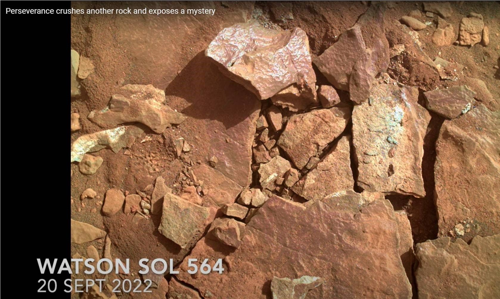
The NASA Perseverance rover crushed another rock on Mars and exposed a mystery.
Explains Mars Guy (Steve Ruff of Arizona State University), after returning to a location dubbed Enchanted Lake, NASA’s Perseverance Mars rover attempted an abrasion operation on a rock too weak to handle it. The rock shattered into pieces, revealing a paint-like purple coating that defies easy explanation.
Credit: Mars Guy
Go to this Mars Guy video for details at: https://youtu.be/00P7ZgrBfLc

Image acquired on Sept. 24, 2022 (Sol 567 of the Perseverance rover mission) using its navigation camera mounted in the helicopter’s fuselage and pointed directly downward to track the ground during flight.
Image Credit: NASA/JPL-Caltech
NASA Ingenuity Mars Helicopter looks to have carried out flight number 33.
According to JPL, the craft was targeted to head West; reach a maximum altitude of 33 feet (10 meters); the expected distance was to be roughly 365 feet (111.238 meters) flying at 10.6 mph (4.75 m/s); and an expected time aloft was slated for 55.61 seconds.
The goal of flight 33 was to reposition the helicopter.

Curiosity’s location as of Sol 3601. Distance driven on that sol: 17.83 miles/28.69 kilometers.
Credit: NASA/JPL-Caltech/Univ. of Arizona
NASA’s Curiosity Mars rover at Gale Crater is now performing Sol 3602 duties.
Some fresh new imagery spotlights the surrounding terrain:

Curiosity Right B Navigation Camera photo acquired on Sol 3600, September 22, 2022.
Credit: NASA/JPL-Caltech

Curiosity Mast Camera Right image taken on Sol 3600, September 22, 2022.
Credit: NASA/JPL-Caltech/MSSS

Curiosity Front Hazard Avoidance Camera Right B image taken on Sol 3601 September 23, 2022.
Credit: NASA/JPL-Caltech

Curiosity Left B Navigation Camera image taken on Sol 3601, September 23, 2022.
Credit: NASA/JPL-Caltech

Curiosity Left B Navigation Camera image taken on Sol 3601, September 23, 2022.
Credit: NASA/JPL-Caltech

Air Force Band members and guests sing the new U.S. Space Force service song during the 2022 Air, Space and Cyber Conference in National Harbor, Md., Sept. 20, 2022. (U.S. Air Force photo by Eric Dietrich)
The U.S. Space Force, the newest military branch established in 2019, has officially adopted its own song titled “Semper Supra.” It was unveiled during the 2022 Air & Space Forces Association Air, Space and Cyber Conference in National Harbor, Maryland, Sept. 20.
To listen to the song, go to:
https://www.dvidshub.net/video/857934/us-space-force-reveals-official-song

Map view with base dataset, clickable viewpoints are marked as droplets. (Image: HiRISE/CTX/HRSC)/Europlanet Society
Prospective Mars explorers can now take a walk around the landing site of NASA’s Perseverance rover.
An interactive map that can be accessed through a normal web browser is loaded with orbital imagery, terrain data as well as synthetic and real 3D panoramic views of Jezero crater and its surrounding area.
“The map is the perfect tool for planning a future visit to Mars, with an interactive interface where you can choose from different available base datasets,” explains Sebastian Walter of the Freie Universität Berlin. “Some of the slopes are pretty steep, so watch out for those if you want to avoid too much oxygen consumption!”

Virtual view from top of the western delta into the crater. Credit: HiRISE/CTX/HRSC/Europlanet Society
“To get a real feeling of what to expect on your future Mars trip, you can click on one of the waypoint marker symbols to enter either a full-screen 3D view or, if you have a Virtual Reality setup, to enter a fully immersive environment. You can even listen to the sounds of the rover if you stand close by, but please don’t touch it – otherwise you would contaminate the probes.”
The base layer of the map is a merged dataset derived from three different instruments currently orbiting Mars, carried by Europe’s Mars Express, and NASA’s Mars Reconnaissance Orbiter.
Go to this direct link to the interactive map (wait for map to fully unfold):
https://maps.planet.fu-berlin.de/jezero
Also, for more details, go to this Europlanet Society news release – “Virtual hiking Map for Jezero Crater, the Mars 2020 Perseverance Rover Landing Site” – at:
https://www.europlanet-society.org/virtual-hiking-map-for-jezero-crater/

Russia’s Igor Mitrofanov
Credit: ESA–Stephane Corvaja
Russia’s lunar exploration program faces delay, according to Igor Mitrofanov, head of the Department of Nuclear Planetology of the Space Research Institute (IKI) of the Russian Academy of Sciences.
The first robotic Moon mission, Luna-25 had been previously postponed to 2023. Now the launches of Luna-26, Luna-27 and Luna-28 may be postponed for up to two years, Mitrofanov told Russia’s TASS news agency.

Luna-25
Credit: NPO Lavochkin
The Luna-26 mission was to be launched in 2024, Luna-27 in 2025, Luna-28 in 2027-2028.
Supply chain issue
“Our main problem today, which has a fundamental impact, is import substitution. Because of this, the dates will be postponed, maybe each mission will be postponed for a year, maybe even for two,” Mitrofanov said.
According to Mitrofanov, supply chain issues of certain components have forced the delay of a string of Luna probes.

Luna-26
Credit: NPO Lavochkin
The suite of Moon probes are part of the Luna-Glob program by Roscosmos.
The Luna-25 spacecraft is a small-sized demonstration landing station for testing basic soft landing technologies in the circumpolar region and conducting contact studies of the south pole of the Moon.

Luna-27
Credit: NPO Lavochkin
Luna-26 is a lunar orbiter designed to carry out remote sensing of the lunar surface.
Luna-27 is intended to be a lander for testing the technology of high-precision and safe touchdown landing in the Moon’s south pole region, including drilling to a depth of 2 meters using a cryogenic deep drilling rig.

Luna-28
Credit: NPO Lavochkin
Luna-28 is designed for delivery back to Earth of lunar soil from the region of the south pole of the Moon.

