Archive for the ‘Space News’ Category
 Author:
  August 7th, 2023
Credit: NPO Lavochkin
Russia’s Roscosmos has posted the liftoff date/time for the country’s Luna-25 robotic Moon lander: August 11 at 02:10:57 Moscow time.

South pole landing areas.
Image credit: Roscosmos/Tass
Luna-25 is targeted for a south pole landing, with the probe testing out soft landing technology, analyze the soil, conduct long-term scientific research, as well as investigate the lunar exosphere.
Meanwhile, at the Vostochny Cosmodrome, booster preparation to hurl the craft skyward is underway. Final checks of the Soyuz-2.1b booster with its Fregat upper stage.

Image credit: Vostochny Space Center

Image credit: Vostochny Space Center

Image credit: Vostochny Space Center
 Posted in

Image credit: ISRO
India’s Chandrayaan-3 Moon lander/rover mission is in a lunar orbit of 102 miles (164 kilometers) by 11,230 miles (18,074 kilometers), as intended. The next maneuver by the Moon-orbiting spacecraft is scheduled for August 6, between 22:30 and 23:30 Indian Standard Time (IST).
According to the Indian Space Research Organization (ISRO), as the mission progresses, a series of maneuvers are to gradually reduce Chandrayaan-3’s orbit and position it over the lunar poles. At the appointed time, Chandrayaan-3’s propulsion module will separate from the lander while in orbit.

Image credit: ISRO
The propulsion module will carry the lander and rover configuration until a 62 miles (100 kilometers) lunar orbit above the Moon’s terrain is achieved. The propulsion module has a Spectro-polarimetry of HAbitable Planet Earth (SHAPE) payload to study the spectral and polarimetric measurements of Earth from lunar orbit.
Complex braking maneuvers
A series of complex braking maneuvers will be executed to facilitate a soft landing in the south polar region of the Moon on August 23, 2023.

Image credit: ISRO
ISRO notes that, throughout the mission, the health of the spacecraft is being continuously monitored from the Mission Operations Complex at ISRO Telemetry, Tracking, and Command Network, the Indian Deep Space Network antenna at Byalalu, near Bengaluru, with the support from the European Space Agency (ESA) and the NASA/Jet Propulsion Laboratory’s Deep space antenna.

Screengrab image from India’s Chandrayaan 3 from lunar orbit.
Image credit: ISRO/Inside Outer Space screengrab

Image credit: Mars Guy/NASA/JPL-Caltech
“On July 31, Perseverance spotted Ingenuity in a place far from its last known location but well short of where it was supposed to be based on the posted flight plan. Does this mean that Ingenuity had an emergency landing?”

Image credit: Mars Guy/NASA/JPL-Caltech
Mars Guy explores the altering of NASA’s Ingenuity helicopter’s flight plan in this new video at:

Perseverance took this August 3 image of Ingenuity via its Left Mastcam-Z Camera. Image credit: NASA/JPL-Caltech/ASU

Image credit: Visual Capitalist/Preyash Shah
Just how much human-made space garbage is currently circling the Earth? What countries are in the “space junk race” to clutter up the heavens?
The folks at Visual Capitalist have created the infographic: “Space Debris: The Earth’s Orbiting Threat,” an effort led by Preyash Shah, expert in technology, business and maps for the group.
Country culpability
Shah notes that, in July, an odd object washed up on a remote beach in Western Australia. This chunk of golden metal was later identified as a spent rocket stage.

most likely debris from an expended third-stage of a Polar Satellite Launch Vehicle (PSLV) – a medium-lift launcher operated by the Indian Space Research Organization (ISRO).
Image credit: Australian Space Agency
Earth is encircled by thousands of defunct satellites, spent rocket stages, metal shards from collisions, all orbiting our planet at breakneck speeds.
In this graphic, Preyash Shah uses tracking data from the Space-Track.org, maintained by the U.S. Space Force, to help visualize just how much debris is currently orbiting the Earth, while identifying the biggest contributors of this celestial clutter.
For further information, go to: https://www.visualcapitalist.com/cp/space-debris-by-country/
Also, visit Visual Capitalist at: https://www.visualcapitalist.com/

NASA’s Mars Perseverance rover is busy at work, on a roll to find evidence of past microbial life on the Red Planet. This older rover selfie captured Ingenuity, the Mars helicopter.
Image Credit: NASA/JPL-Caltech/MSSS
The Ingenuity helicopter flew its 54th time, a pop-up flight with the device achieving hovering mode to altitude of 16 feet (5 meters), staying aloft for 24.62 seconds.

Image Credit: NASA/JPL-Caltech

Image Credit: NASA/JPL-Caltech
These rotorcraft images were acquired on August 3, taken by its navigation camera mounted in the craft’s fuselage and pointed directly downward.
Meanwhile, NASA’s Mars Perseverance rover acquired this image of Ingenuity and its surroundings using its Left Mastcam-Z camera. Mastcam-Z is a pair of cameras located high on the rover’s mast.

Image Credit: NASA/JPL-Caltech/ASU

Mosaic of the Valles Marineris hemisphere of Mars composed of 102 Viking Orbiter images of this huge feature on the Red Planet.
Image credit: NASA, USGS, Viking Project
A just-issued report offers a new avenue for exploring Mars, one that would entail flying lower-costing missions to the Red Planet.
A Mars Concurrent Exploration Science Analysis Group has scoped out the highest priority science that should be conducted in parallel with the NASA/European Space Agency Mars Sample Return (MSR) program – the mega-billion dollar undertaking now being blueprinted.

Mars sample return to Earth – a major undertaking by NASA, the European Space Agency.
Image credit: NASA/JPL-Caltech
Interconnected network
Flinging less-costly missions to Mars in the next decade (2023-2032) is tagged the “Braided River” approach. The tactic is an interconnected network of low-cost missions working together to address major outstanding Mars questions, driven by the sheer dynamic nature of the planet itself.
Multiple small, low-cost missions, orbiters, soft and hard landers could work together to address larger outstanding Mars questions.

The Rakaia river, in Canterbury, New Zealand, illustrating the concept of a ‘Braided River’
with interconnecting, merging, and splitting tracks. Image by Andrew Cooper
(https://commons.wikimedia.org/wiki/User:Andrew_Cooper#/media/File:Rakaia_River_NZ_aeri
al_braided.jpg), licensed under CC BY 3.0 (https://creativecommons.org/licenses/by/3.0/)
Final five
The study group identified a “final five” Mars science objectives that can benefit by the Braided River approach: planetary evolution; early environmental change; recent climate evolution; dynamic modern environments and modern habitability – the search for currently or recently habitable environments and present-day life on Mars.
Although challenging, a lower-cost mission initiative as envisioned by the group offers the chance to augment or replace existing infrastructure, provide landing site evaluation, make on-the-spot resource utilization assessments, and perform weather monitoring, “all of which will be critical for both future robotic and human exploration,” the group’s study report notes.

Depiction shows Jezero Crater — the landing locale of the Mars 2020 Perseverance rover — as it might have appeared billions of years ago when it was perhaps a life-sustaining lake. An inlet and outlet are also visible on either side of the lake.
Image Credit: NASA/JPL-Caltech
Search for life
As for the search for modern/extant life on Mars, the report explains that accessing the deeper subsurface where liquid water could be stable will be crucial to accessing habitable modern ecosystems where the harsh surface conditions are minimized, such as radiation.
A first key investigation to better understand the habitability and likelihood of extant life in the subsurface today would be to confirm or refute the hypothesis of a global deep aquifer on Mars.
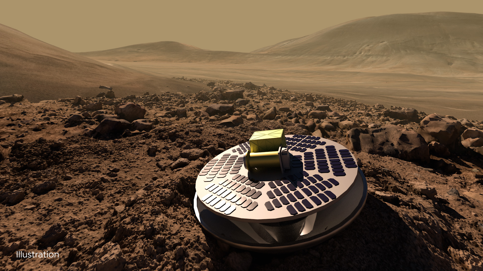
A current illustration of SHIELD that would allow lower-cost missions to reach the Red Planet’s surface by safely crash landing, using a collapsible base to absorb the impact. Image credit: California Academy of Sciences
Spotlighted in the report is subsurface sounding via a lander.
Also, a single lander or network of landers might make rapid, accurate measurements of the abundance of potentially biogenic gases like methane at the surface of Mars. Taken at hourly to annual timescales, data collected could help resolve many outstanding questions. Such a mission would also benefit from wind measurements to help further pinpoint the source of emitted gases.
Landing forces
One concept for a hard lander system able to deliver payloads to Mars is called SHIELD, short for Small High-Impact Energy Landing Device being developed at JPL. The SHIELD design omits heatshields, parachutes, and thrusters. It uses a basic impact attenuation system to help squelch much higher landing forces as contrasted to past Mars soft landings.
An ultra-compact ground penetrating radar is also under development as a Mars science helicopter payload.

The Red Planet as seen by Europe’s Mars Express.
Image credit: ESA/D. O’Donnell – CC BY-SA IGO
Such a high-flying radar could map layers in rock to a depth of approximately 65 feet (20 meters) and in ice to greater depths. By flying over troughs in the north polar layered deposits on Mars, this technique could potentially map a few hundred meters of ice layers spanning hundreds of thousands of years of deposition.
Business model
Highlighted in the report is need for adoption of a well-developed business model, one that “balances optimism and practicality through sound business acumen” and incorporates viable involvement of the commercial space industry.
To that end, the report points to NASA’s Commercial Lunar Payload Services (CLPS) program for the Moon as a possible model for low-cost Mars exploration.
“To date, however, no CLPS missions have flown, and so it remains to be seen the level of success attained by this program,” the report adds.

An expeditionary crew on Mars sets up drilling gear in a quest to utilize ice for sustaining a human presence on the Red Planet.
Image credit: NASA
Clear, cohesive, inspiring
The Braided River approach to investigating Mars in a less-costly manner can fill major knowledge gaps within a clear, cohesive, and inspiring program.
However, the report concludes that, for such a program to be successful and paradigm changing, “it would need to be well supported by frequent solicitations, regular launches, and robust technology development programs.”
It is the opinion of study group members that this Braided River proposal would be highly complementary to the existing Mars Exploration Program mission portfolio “and inject the excitement and novelty of a decidedly new approach to exploring the Red Planet.”
To review the full report by the Mars Concurrent Exploration Science Analysis Group, chartered by the Mars Exploration Program Analysis Group (MEPAG), go to:
https://www.lpi.usra.edu/mepag/reports/reports/MCE_SAG_Final_Report.pdf

View of Giordano Bruno crater on the far side of the Moon.
Image credit: NASA
How can you transport materials across the Moon’s surface and keep annoying, debilitating dust out of lunar habitats?
Enter a Caltech team that is designing a Lunar Architecture for Tree Traversal in-service-of Cable Exploration, space speak boiled down to LATTICE.
The LATTICE team is looking into a self-deploying modular robotic system for transporting ice and other assets in and out of craters.

Image: Caltech LATTICE team.
The ski lift-like system would work like a zip line on the Moon, complete with driving stakes in the ground, cables are then attached to the stakes, and cargo would be transporting by the cables in robotic shuttles.
Prototype tested
LATTICE was among seven finalists in NASA’s 2022 Breakthrough, Innovative, and Game-changing (BIG) Idea Challenge.

Testing of hardware underway at Caltech.
Image credit: Caltech/LATTICE Team
Last November, the LATTICE team tested a small-scale prototype of its system in a desert in California’s Lucerne Valley.
The Caltech team has also blueprinted HOMES – shorthand for Habitat Orientable & Modular Electrodynamic Shield.
Check out this video at: https://youtu.be/i8O0wPSCtjg

Kathy Sullivan, the first American woman to walk in space and a veteran of three shuttle missions, created the highly-informative Kathy Sullivan Explores podcast.
Since June 2021, the podcasts have focused on science, art, space, and the most memorable moments of Sullivan’s life so far.
Listen to her short “Farewell for Now” episode and also revisit the wellspring of past podcasts that embrace the spirit of curiosity, adventure, and discovery.
Go to: https://www.kathysullivanexplores.com/podcast/farewell-for-now
And while there, go to Sullivan’s “Seven Astronaut Tips for Improving your Life on Earth,” at

India’s Chandrayaan-3 Moon lander.
Image credit: ISRO
India’s ambitious Moon exploration spacecraft, the Chandrayaan-3, is now en route to its lunar target. The lander is to unleash a rover, both stuffed with scientific instruments to inspect the lunar surface in the southern lunar hemisphere.
“Next stop: the Moon,” declared an Internet posting from the Indian Space Research Organization (ISRO). All appears on track for the Chandrayaan-3 to swing into lunar orbit on August 5.

NASA-supplied laser retroreflector array is mounted atop India’s lunar lander. Device can help precisely pinpoint the whereabouts of a Moon lander.
Image credit ISRO/NASA
India’s lander will then head for a touchdown on August 23 within the southern region of the Moon’s near side, soft landing about 13 miles (20 kilometers) west of the Manzinus U crater rim.
Go to my new Multiverse Media SpaceRef story – “India’s Moon Shot Adds to Country’s Growing Space Endeavors” – at:
https://spaceref.com/science-and-exploration/indias-moon-shot-countrys-growing-space-endeavors/

China’s Chang’e-7 lander launches hopper craft to search for lunar ice.
Image credit: CCTV/CNSA/Inside Outer Space screengrab
China’s Moon exploration plans call for deep diving into permanently shadowed areas of the lunar south pole. The country’s Chang’e-7 mission is slated to take place around 2026 and utilize a mini-flying probe to investigate the permanently-shadowed bottom of an impact crater.
The Chang’e-7 mission consists of an orbiter, lander, the hopper and a rover and is targeted for a touchdown in a southeastern area of Shackleton crater.

In this multi-temporal illumination map of the lunar south pole, Shackleton crater (19 km diameter) is in the center, the south pole is located approximately at 9 o’clock on its rim. The map was created from images from the camera aboard the Lunar Reconnaissance Orbiter.
Credits: NASA/GSFC/Arizona State University
A drilling tool on the mobile probe will sample lunar soil water-ice before a mechanical arm moves that sample into a heating furnace for spectral analysis. A Lunar Water Molecular Analyzer (LWMA) on the mini-flyer will appraise lunar soil water-ice in the surface frost layer.
Different depths
According to Yingzhuo Jia of the National Space Science Center in Beijing, the LWMA has the ability to “analyze samples for many times and can take samples at different depths and locations for many times, so as to obtain the data of water-ice content varying with depth and region.”

NASA Administrator Bill Nelson discusses lunar landing sites as he testifies during an April House Science, Space and Technology Committee hearing.
One photo – multiple nations headed for lunar territory.
Image credit: NASA/Bill Ingalls
Yingzhuo and colleagues note that results from the on-the-fly hopper “can also provide evidence of the composition and content of direct volatile matter, whether it contains H₂O, H₂S, NH3, SO₂, and other volatile matter, and whether more volatile matter is deposited in the permanent shadow areas compared with the existing results of Apollo samples or lunar meteorites.”
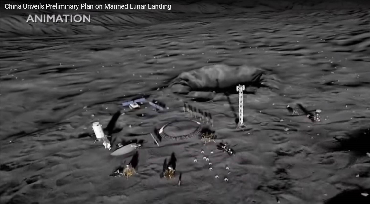
Artist’s view of International Lunar Research Station to be completed by 2035. Credit: CNSA
An overview of the Chang’e-7 mission objectives – “Research of Lunar Water-Ice and Exploration for China’s Future Lunar Water-Ice Exploration” has been published in the open access journal Space: Science & Technology at: https://spj.science.org/doi/10.34133/space.0026
In related Moon work, also published in the journal, go to – “Overview of the Lunar In Situ Resource Utilization Techniques for Future Lunar Missions” – at:

