Author Archive

Image of China’s Chang’e 3 lunar lander taken by Yutu rover.
Credit: Chinese Academy of Sciences
Chinese space officials have spotlighted the year-long scientific work of the still operating Chang’e 3 lander.
The spacecraft touched down on the Moon’s surface on December 14, 2013. It carried the Yutu rover that was deployed from the stationary lander to roam freely across the lunar terrain.
The state-owned news agency, the People’s Daily, quotes Cui Yan, chief designer of the Chang’e-3 lunar program at the Beijing Aerospace Control Center (BACC).
During its year on the lunar surface, which included 13 dormancies on lunar nights and awakenings on lunar days, the Chang’e 3 lunar lander endured the extreme cold environment and carried out more than 30 radio surveys, Cui says, adding that the lander will continue to carry out additional tasks.
“The Chang’e 3 lander has accomplished all its scheduled tasks in its expected lifetime,” Cui said. “But given its good condition, we plan to conduct further experiments to accumulate more technical experience for China’s deep space exploration.”
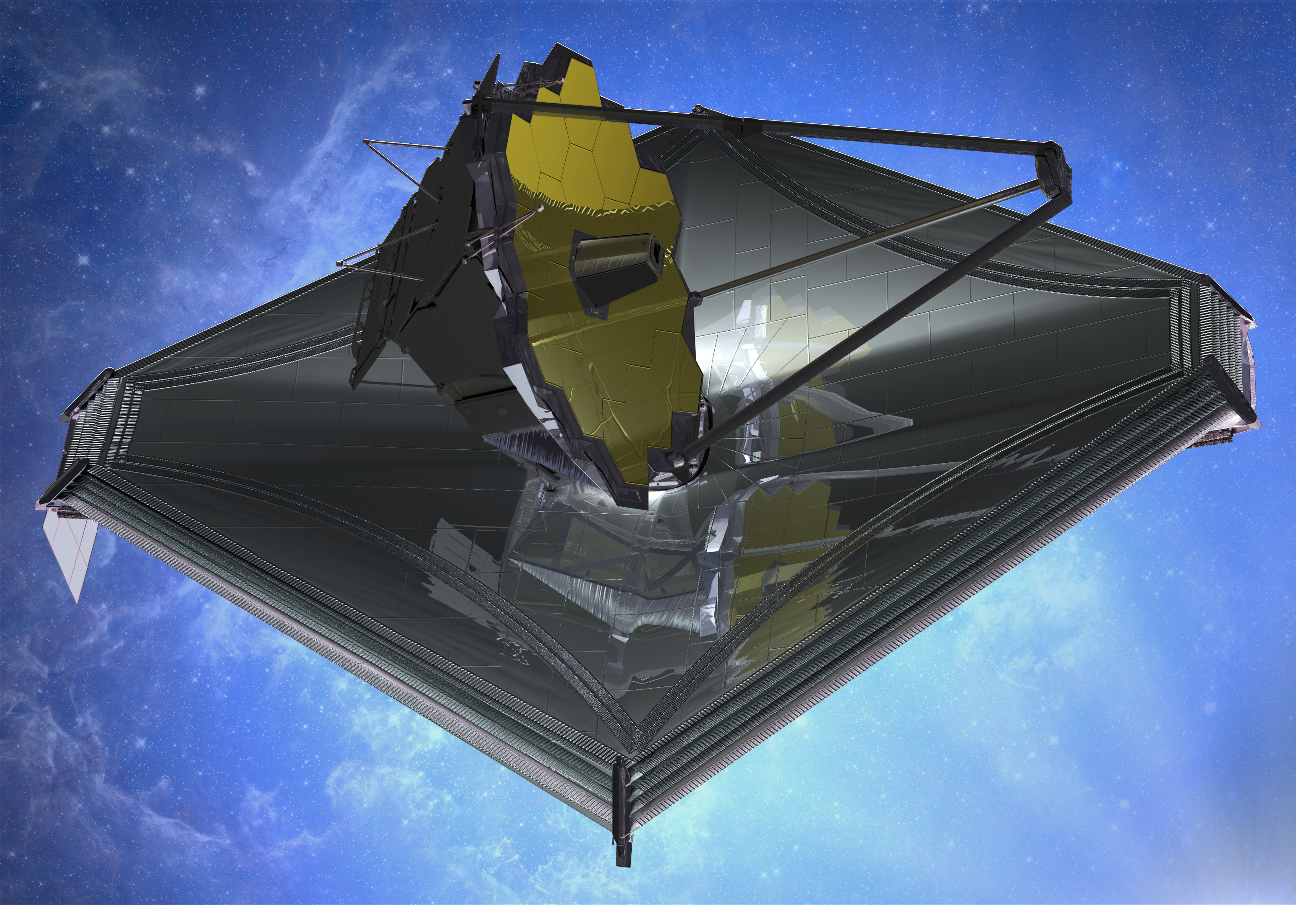
August 2013 artist’s impression of James Webb Space Telescope.
Credit: Northrop Grumman
A new study by the Government Accountability Office (GAO) has taken a look at the James Webb Space Telescope (JWST) project.
JWST is one of NASA’s most complex and expensive projects, at an anticipated cost of $8.8 billion.
The GAO has found that with just less than 4 years until its planned launch in October 2018, the JWST project reports the effort remains on schedule and budget.
However, the GAO reports, technical challenges with JWST elements and major subsystems have diminished the project’s overall schedule reserve and increased risk.
During the past year, the GAO reports that delays have occurred on every element and major subsystem schedule — especially with the cryocooler — leaving all at risk of negatively impacting the overall project schedule reserve if further delays occur.
 The cryocooler chills an infrared light detector on one of JWST’s four scientific instruments.
The GAO report assesses, among other issues, the extent to which (1) technical challenges are impacting the JWST project’s ability to stay on schedule and budget, and (2) budget and cost estimates reflect current information about project risks.
For your own review of the report, go to:
James Webb Space Telescope: Project Facing Increased Schedule Risk with Significant Work Remaining. GAO-15-100, December 15.
http://www.gao.gov/products/GAO-15-100
Highlights – http://www.gao.gov/assets/670/667527.pdf
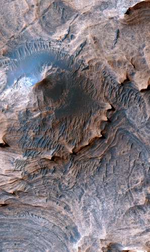
Enhanced color image of a hill in the Candor Colles region of Candor Chasma, Mars. Image is 1 km (0.62 miles) across.
Credit: USGS/NASA/JPL/University of Arizona
Want to stroll around on the Red Planet?
If so, you may put in your backpack a new U.S. Geological Survey (USGS) geologic map of Mars, billed as the most detailed representation of the Red Planet to date.
This new map provides geologic and structural information on layered sedimentary rocks at a scale comparable to what a field geologist would see on Earth, including a precise illustration of a portion of the “Grand Canyon of Mars,” or Valles Marineris.
The map provides new targets for continued scientific investigation of past potentially habitable environments on Mars.
The just released USGS geologic and structural map uses the highest-resolution, orbiter-based images currently available for Mars – data from the High Resolution Imaging Science Experiment (HiRISE) camera on board the NASA Mars Reconnaissance Orbiter.
The area analyzed, called western Candor Chasma, is one of the largest canyons in the Valles Marineris canyon system. The resulting map provides the most detailed information of the geology of Mars at a human scale over a broad area of terrain.
A unique feature of this map is that its resolution, or scale, is sufficiently detailed that USGS cartographic standards used in terrestrial, Earth-based geologic and structural maps were used. And that’s a first for a map of another planet.
The project was funded by the NASA Planetary Geology and Geophysics Program.
It’s available from the USGS for download online at:

After releasing a test return capsule, the service module is headed for Moon orbit.
Credit: China Space Website
China is prepared to move a spacecraft into lunar orbit next month – the service module involved in the country’s successful circumlunar return capsule test in November.
After the separation of the return capsule that parachuted into Inner Mongolia, the larger service module continued its mission back to the vicinity of the Moon.
Following two key maneuvers it arrived in a Lagrangian Point (L2) in late November.
Now that service module is slated to leave L2 at the beginning of January and head for the Moon, braking into lunar orbit in mid-January.

China’s Chang’e 5 mission is slated for 2017 and will land, collect, and return to Earth lunar samples.
Credit: China Space Website
The orbiter is outfitted with GPS, a high-resolution camera and a star sensor, among other equipment. That camera gear can survey areas where a follow-on Moon mission – Chang’e 5 – is to land, gather lunar surface samples, and then return the specimens to the Earth.
Chang’e 5 is reportedly headed for a 2017 liftoff.
As reported in the state-owned China Daily, Pei Zhaoyu, deputy director of the China National Space Administration said:
“To take maximum advantage of the capacity of the service module to test relevant technologies for Chang’e 5, we are conducting a series of experiments on the service module, including circling the Lagrangian Point L2 and carrying equipment for experiments in orbit.”
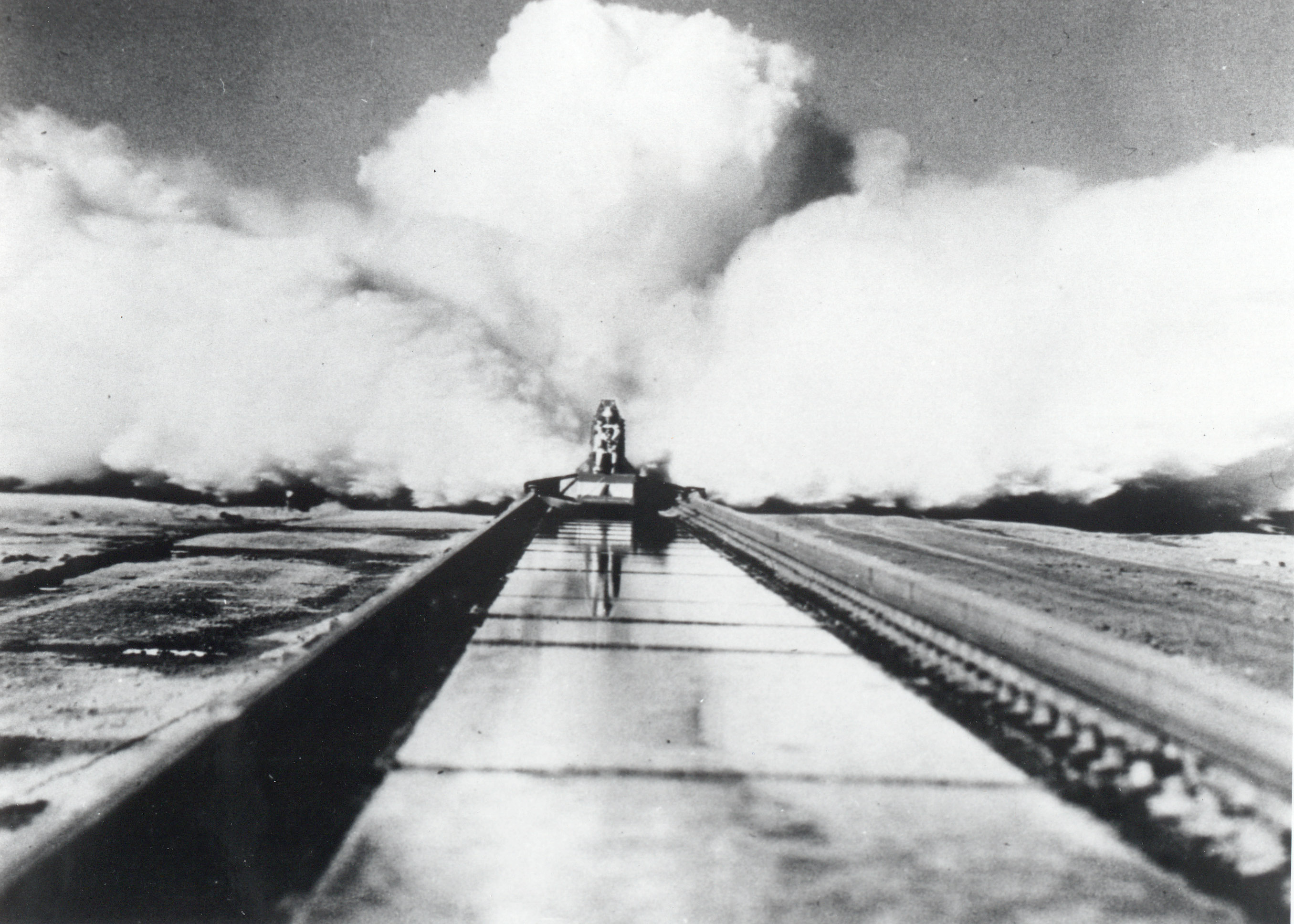
December 10, 2014 marks the 60th anniversary of Col. John P. Stapp’s record-breaking experiment at the Holloman High Speed Test Track.
Credit: U.S. Air Force/Courtesy Photo
It has been 60 years since Col. John P. Stapp sailed down a test track, strapped in tight onboard Sonic Wind Rocket Sled 1.
That pioneering ride on Dec. 10, 1954 earned Stapp the title, “The Fastest Man on Earth” – a speedy rocket-powered trip that propelled him to a rate of 632 miles per hour and subjected the test subject to more than 40 g’s given the rocket sled’s 1.4 second stop in motion.
The site of his adventure was the Holloman High Speed Test Track in New Mexico, an experiment to ascertain the impact on a pilot ejected at 35,000 feet at twice the speed of sound.

Full stop! A pioneering rocket sled ride. Even in black & white it hurts.
Credit: US Air Force
Stapp sustained bruises, blisters and temporary blindness.
Images of that experiment were publicized around the world. And for aspiring space cadets it was an early, albeit scary, introduction to rocket travel and g-force face time!
Sled on display
Visitors to the New Mexico Museum of Space History in Alamogordo, New Mexico can view the Sonic Wind Rocket Sled 1.
The sled is on display within The John P. Stapp Air & Space Park, named after International Space Hall of Fame Inductee and aeromedical pioneer.

Photo courtesy of NMMSH/The John P. Stapp Air & Space Park
Stapp retired from the U.S. Air Force in 1970 as a colonel and died at his home in Alamogordo, N.M. in 1999.
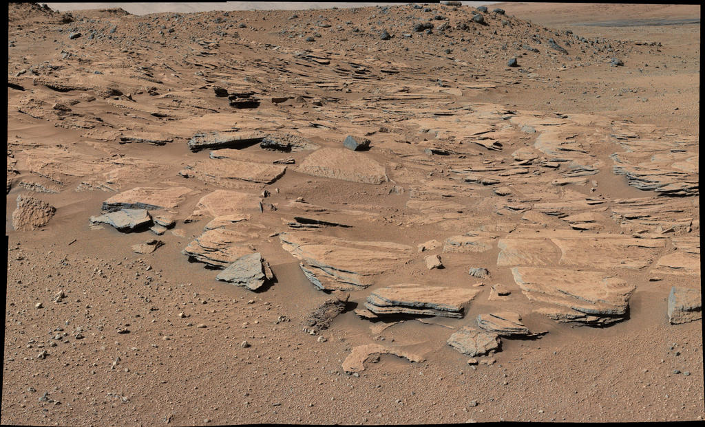
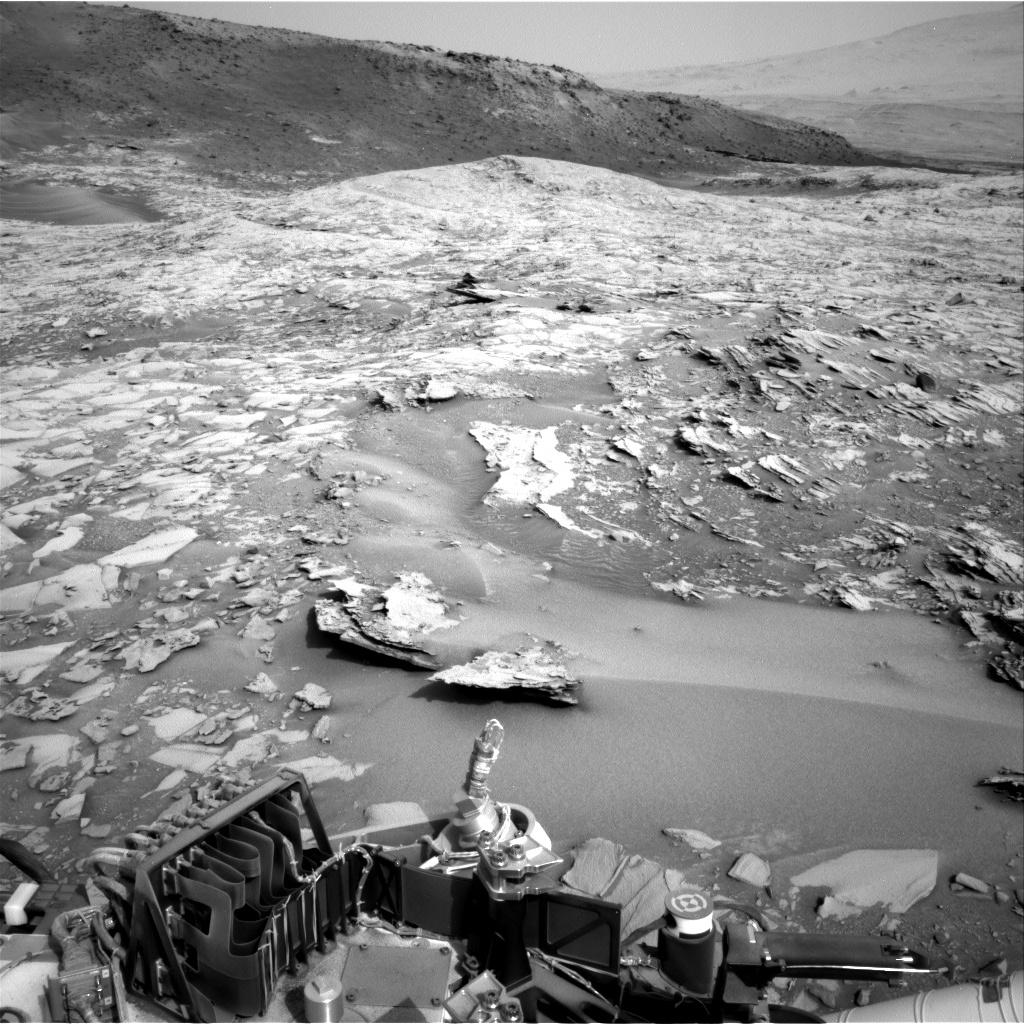
This image taken by the Mast Camera (Mastcam) on NASA’s Curiosity Mars rover just north of the “Kimberley” waypoint shows beds of sandstone inclined to the southwest toward Mount Sharp and away from the Gale Crater rim.
Image Credit: NASA/JPL-Caltech/MSSS
NASA’s Curiosity Mars rover continues on its 5 mile (8 kilometer) journey from its landing site in August 2012 to its current work site at the base of Mount Sharp.
The robot has uncovered clues about the changing shape of the crater floor during an era of lakes, according to research scientists.
Curiosity currently is investigating the lowest sedimentary layers of Mount Sharp, a section of rock 500 feet (150 meters) high, dubbed the Murray formation. Rivers carried sand and silt to the lake, depositing the sediments at the mouth of the river to form deltas similar to those found at river mouths on Earth. This cycle occurred over and over again.

NASA’s Mars rover Curiosity acquired this image on December 11, 2014 using its Mars Hand Lens Imager (MAHLI), located on the turret at the end of the rover’s robotic arm.
Image Credit: NASA/JPL-Caltech/MSSS
Meanwhile, attention is also being paid to the wear and tear on the rover’s set of wheels. Damage to the wheels due to drives over rough terrain is carefully monitored.
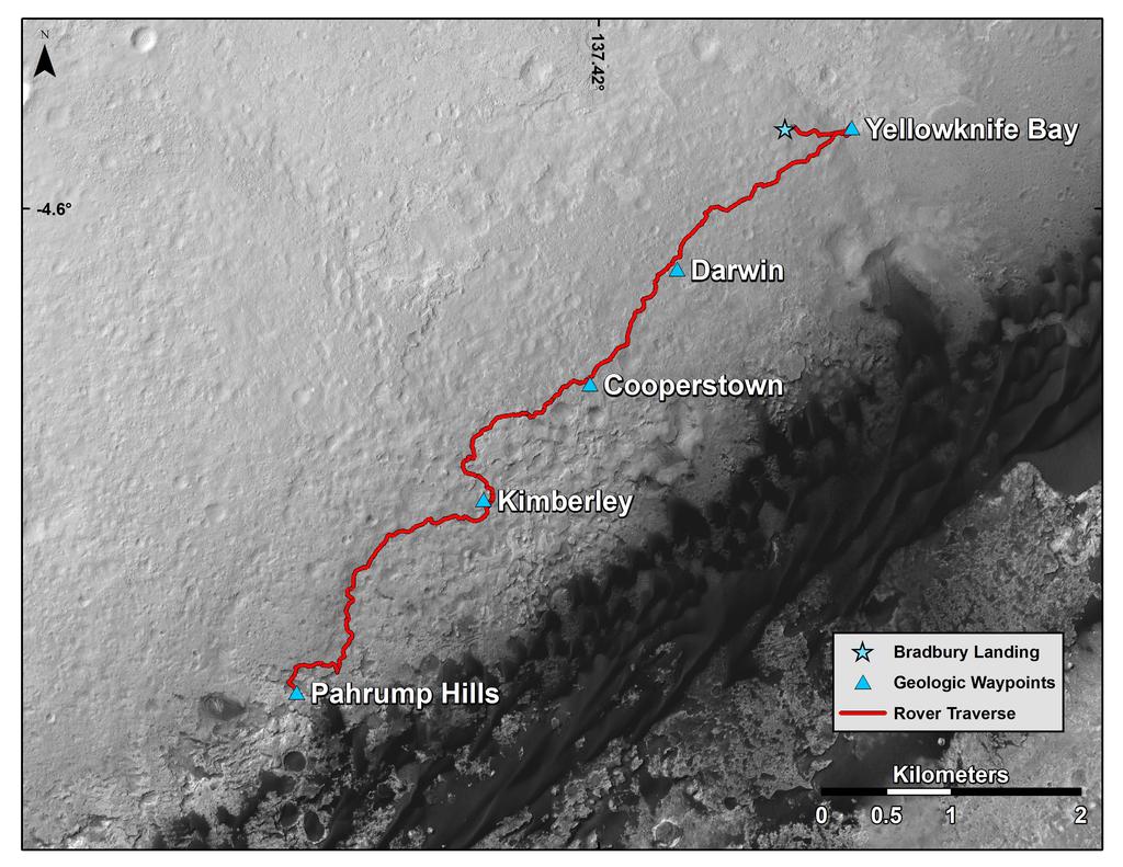
This map shows the route driven by NASA’s Curiosity Mars rover from the location where it landed in August 2012 to the “Pahrump Hills” outcrop, which is part of the basal layer of Mount Sharp.
The traverse line covers drives completed through the 817th Martian day, or sol, of Curiosity’s work on Mars (Nov. 23, 2014).
Image Credit: NASA/JPL-Caltech/Univ. of Arizona

Credit: ShareSpace Foundation
Foo Fighting Friends:
Apollo 11 moonwalker, Buzz Aldrin, and Dave Grohl, Foo Fighters front-man.
Shirts can be purchased at:
The proceeds for the sales of the shirts will go directly to the ShareSpace Foundation at:

Credit: ShareSpace Foundation

SHERPA, a hosted payload and in-space transportation platform.
Credit: Spaceflight Inc.
The Defense Advanced Research Projects Agency (DARPA) is pushing forward on its agenda to enable robotic servicing of spacecraft.
That work is being done under the Phoenix initiative – and one of its goals is to validate new satellite assembly architectures.
Never accused of skimping on innovation, DARPA is delving into “Satlets” – new low-cost, modular satellite architecture that can scale almost infinitely.
Independent modules
Satlets are small independent modules that weigh roughly 15 pounds (7 kilograms) that incorporate essential satellite innards, like power supplies, movement controls, sensors, etc.
Satlets share data, power and thermal management capabilities.
Satlets also physically aggregate (attach together) in different combinations that would provide capabilities to accomplish a range of diverse space missions with any type, size or shape payload.
Because they are modular, they can be produced on an assembly line at low cost and integrated very quickly with different payloads.
DARPA is keen on validating the technical concept of satlets in low Earth orbit.

“Satlets” – new low-cost, modular satellite architecture that can scale almost infinitely.
Credit: DARPA
In-space transportation platform
Seattle-based Spaceflight Inc., has announced its role in the concept of the new architecture based on the firm’s SHERPA, a hosted payload and in-space transportation platform.
On Dec. 9 the company announced it has signed NovaWurks, Inc., to a launch services agreement for the eXCITe spacecraft.
NovaWurks, located in Los Alamitos, California, is developing eXCITe as part of the DARPA Phoenix program. Earlier this year, DARPA awarded prime contracts for follow-on phase work on the Phoenix effort to NovaWurks and 7 other companies.
The eXCITe spacecraft would ride to low Earth orbit on Spaceflight’s SHERPA in-space transportation platform – scheduled for launch along with roughly 2,645 pounds (1,200 kilograms) of other small satellite rideshare customers in the third quarter of 2015.
eXCITe uses NovaWurks’ Hyper-Integrated Satlet, or HISat™ platform that can be configured as a Conformal Spacecraft™.
Trailblazing time
Curt Blake, President of Spaceflight, said in a press statement: “DARPA’s Phoenix program is a near perfect fit with SHERPA’s capabilities, which will open up additional access to space on commercial launch vehicles, as well as acting as an enabler for future missions to unique orbits.”
Blake added that the partnership with NovaWurks spotlights the exciting and cutting-edge trailblazing time today for “new business models and concepts in the satellite industry.”
For more information on this emerging work, go to these resources:
— DARPA’s Phoenix program at:
https://www.youtube.com/watch?v=OeKzdk0sWjI
— Spaceflight Inc., at:
http://spaceflightservices.com/
— NovaWurks’ HISat and Conformal Spacecraft technology at:
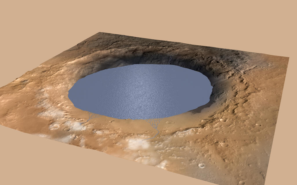
This simulation depicts a lake partially filling Mars’ Gale Crater, receiving runoff from snow melting on the crater’s rim. Evidence that NASA’s Curiosity rover has found of ancient streams, deltas and lakes suggests the crater held a lake such as this more than three billion years ago.
Image Credit: NASA/JPL-Caltech/ESA/DLR/FU Berlin/MSSS
NASA’s Curiosity Rover is chalking up “powerful new evidence” to how water helped shape the Martian landscape.
But the rumor mill is also flowing about a new finding that the robot has detected methane.
On-going observations by the robot indicate Mars’ Mount Sharp was built by sediments deposited in a large lake bed over tens of millions of years.
This interpretation of Curiosity’s finds in Gale Crater suggests ancient Mars maintained a climate that could have produced long-lasting lakes at many locations on the Red Planet.
That implies that there might have been enough time for things to get lively on Mars.
Spectrometer reading
According to informed sources, keep an eye on the December 15-19 American Geophysical Union’s annual gathering in San Francisco.
In particular, look for discussion of Mars Science Laboratory work using the tunable laser spectrometer. It is part of the Sample Analysis at Mars (SAM) Instrument Suite.

This picture shows a lab demonstration of the measurement chamber inside the Tunable Laser Spectrometer, an instrument that is part of the Sample Analysis at Mars investigation on NASA’s Curiosity rover.
Image credit: NASA/JPL-Caltech
Methane detection…who cares?
Whether the Martian atmosphere contains traces of the gas has been a question of high interest for years because methane could be a potential sign of life. But it also can be produced without biology.

This image was taken by Front Hazcam: Left B (FHAZ_LEFT_B) onboard NASA’s Mars rover Curiosity on Sol 831 on December 7.
Image Credit: NASA/JPL-Caltech
Part per billion
If indeed methane – CH4 — is “sniffed out” by Curiosity, the key question is how much and does it vary?
Curiosity may be seeing small local increases in CH4.
“Meteorite in-fall brings organic material to Mars and this organic material breaks down and is oxidized mostly to carbon dioxide but some CH4 is released,” explained Chris McKay, a Marsologist at NASA’s Ames Research Center in California.
“Once produced on Mars the lifetime of the CH4 is 300 years against destruction by ultraviolet sunlight,” McKay told me last week. “So calculations suggest that meteoritic input and sunlight destruction balance and the result is a steady level of about one part per billion (ppb) CH4. Curiosity results are consistent with this as the constant background level of CH4 on Mars. This is hardly surprising and not too interesting for astrobiology,” he said.
Bottom line: Just how the methane on Mars story plays out at the AGU meeting, stay tuned regarding Curiosity’s tunable laser spectrometer!
This image was taken by Navcam: Right B (NAV_RIGHT_B) onboard NASA’s Mars rover Curiosity on Sol 831 on December 8.
Image Credit: NASA/JPL-Caltech

Credit: U.S. Navy photo by Mass Communication Specialist 1st Class Gary Keen
Following its first test flight and ocean recovery on December 5, the NASA Orion crew module is seen in the well deck of the amphibious transport dock ship USS Anchorage (LPD 23). The EFT-1 flight of Orion was the fifth at-sea testing of the Orion crew module using a Navy well deck recovery method.
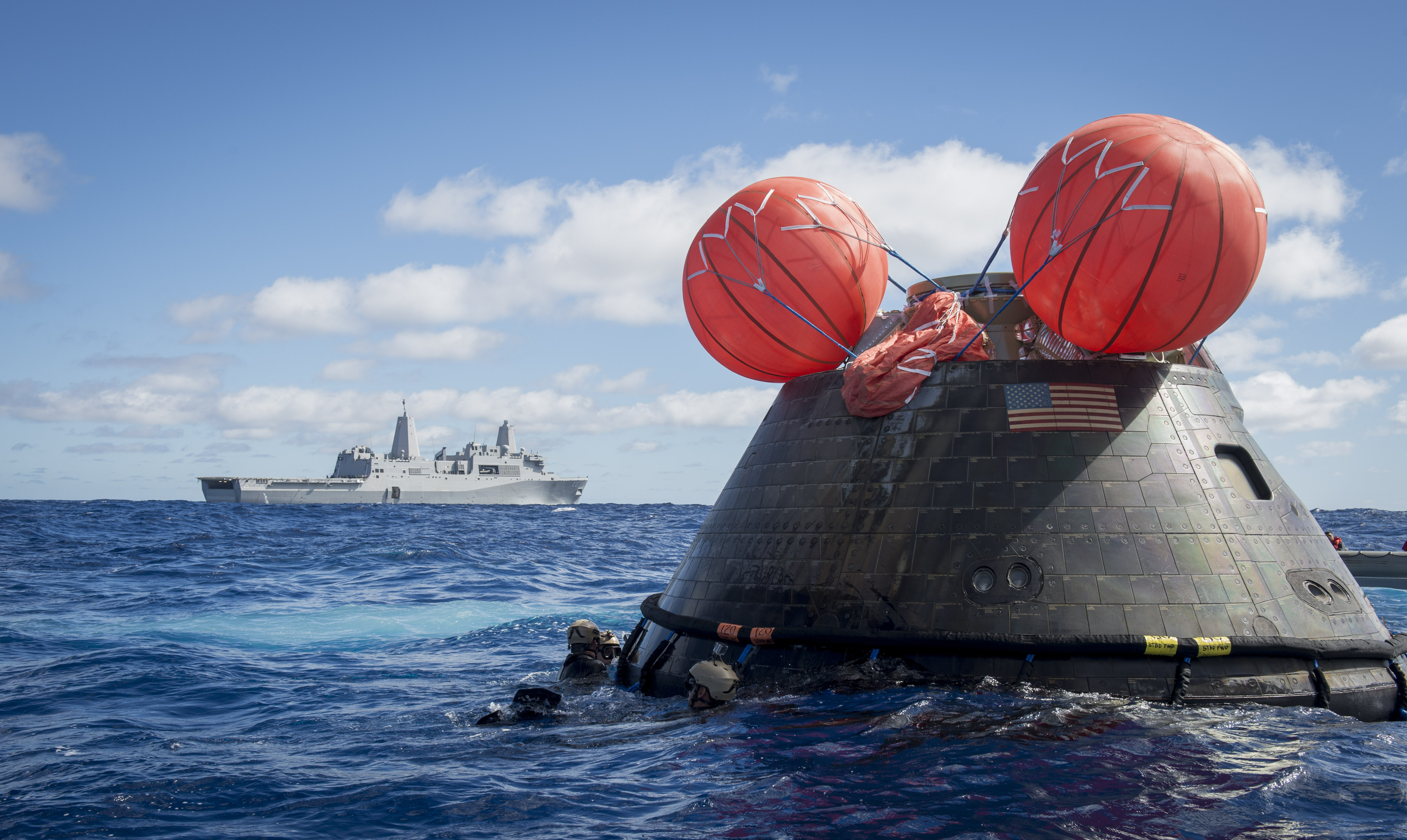
Credit: U.S. Navy photo by Mass Communication Specialist 1st Class Gary Keen
Navy divers assigned to Explosive Ordnance Disposal Mobile Unit (EODMU) 11 and Mobile Diving and Salvage Company 11‐7, recovered the module during the Orion Program’s first exploration flight test.

Credit: U.S. Navy photo by Mass Communication Specialist 1st Class Paul Seeber
The Military Sealift Command diving and salvage vessel USNS Salvor (T-ARS 52), Helicopter Sea Combat Squadron (HSC) 8, Explosive Ordnance Disposal Group 1, Fleet Combat Camera Pacific, and Fleet Weather Center San Diego were also in the Pacific Ocean supporting Orion crew module recovery operations.

Credit: U.S. Navy photo by Mass Communication Specialist 1st Class Corey Green

