Author Archive
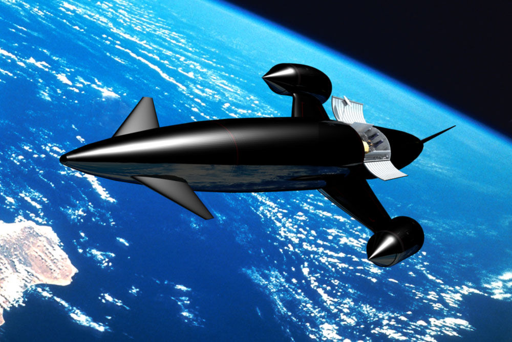
Artwork depicts Skylon space transportation.
Credit: Reaction Engines
The on-going revolution in access to Earth orbit is getting a boost by a new engine test facility.
The Synergistic Air-Breathing Rocket Engine (SABRE) project has been underway for many years, work undertaken by the UK firm, Reaction Engines Ltd.
Work began this week on building the UK’s latest rocket engine test facility, designed for firing the engine core of the SABRE propulsion system within three years.
Ground was broken on the new test facility at Westcott Venture Park in the UK, an historic site for rocket research over the past seven decades.
Test site
The new site will consist of a multipurpose propulsion test stand designed to accommodate various test engine configurations, an assembly building, workshops, offices and control room.

Ground was broken on the new test facility at Westcott Venture Park in the UK.
Credit: Reaction Engines
The location of workshops and other support facilities alongside the test stand will enable configuration changes to the engine to take place at the site, reducing the down time between testing phases and accelerating the engine’s development.
The big scoop
The promise of the SABRE propulsion system concept is to scoop up atmospheric air during the early part of its flight to orbit.
Doing so slashes the need for the vehicle to carry bulky onboard oxygen for this part of the ascent, before switching to rocket mode drawing on internal propellants for its final climb to space.
Single-stage-to-orbit
SABRE is a hybrid jet and rocket engine designed for a single-stage-to-orbit space plane. Incorporating innovative precooler technology able to chill superheated air in a fraction of a second, SABRE would use oxygen from the atmosphere until it reaches above Mach 5, after which it would shift to a closed-cycle rocket mode.
The concept paves the way for lighter and reusable spaceplanes able to fly from conventional runways.
Reaction Engines’ plan for SABRE is to power the over 275-foot long (84 meters) pilotless Skylon.
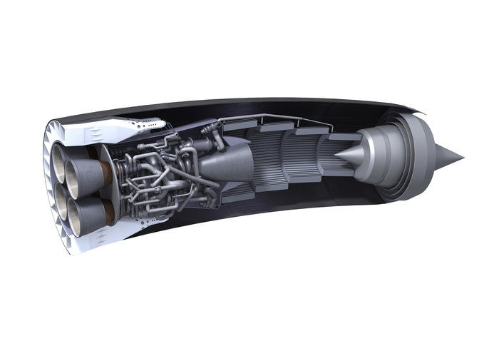
Synergistic Air-Breathing Rocket Engine (SABRE).
Credit: Reaction Engines
Cash flow
According to the European Space Agency, ESA has invested in SABRE, following a 2010 independent review of the engine’s viability, “opening the way” to UK government investment. Reaction Engines Ltd has subsequently received private investment from BAE Systems, focused on accelerating development.
Such engines have the potential to revolutionize space launches, powering vehicles that can take off and land like aircraft. Capable of airbreathing flight up to Mach 5 (five times the speed of sound) they could also lead to hypersonic air travel, according to an ESA press statement.
For more information on Reaction Engines Ltd. go to:
https://www.reactionengines.co.uk/

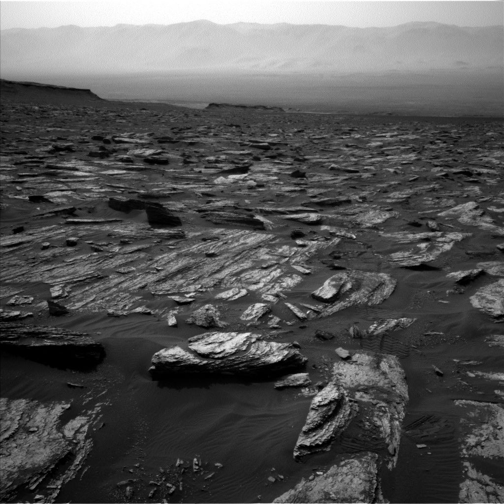
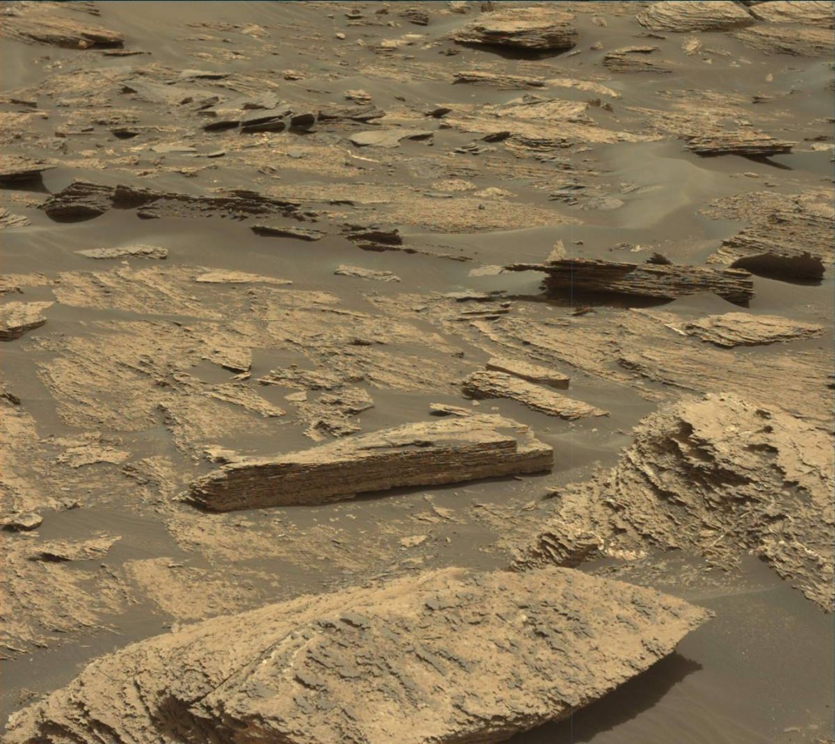
Curiosity Navcam Left B image taken on Sol 1685, May 3, 2017.
Credit: NASA/JPL-Caltech
NASA’s Curiosity rover is now performing Sol 1686 science duties, “continuing the steady march up Mt. Sharp,” reports Michael Battalio, an atmospheric scientist; from Texas A&M University.
Curiosity recently drove 60 feet (18.3 meters) to bring the robot closer to a series of features being called “megaripples” – darker and larger ripples than were seen on the Bagnold Dunes, Battalio adds.
Gauging grain size, distribution
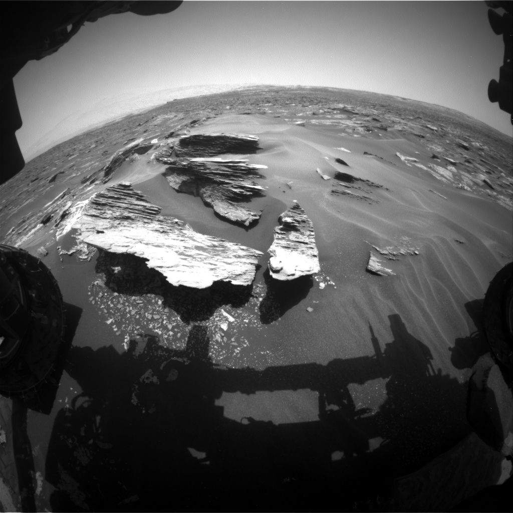
Touch-and-go was again the planning option, with Curiosity carrying out contact science on two targets: “Newport Ledge” and “Sugarloaf Mountain.” These two targets are the closest two rocks protruding above the sand a recent Navcam image.
Curiosity Navcam Left B image taken on Sol 1685, May 3, 2017.
Credit: NASA/JPL-Caltech
Curiosity’s Mars Hand Lens Imager (MAHLI) is scheduled to target Newport Ledge to gauge grain size and distribution.
A series of observations by the robot’s Alpha Particle X-Ray Spectrometer (APXS) and Chemistry & Camera (ChemCam) on Newport Ledge, Battalio adds, will continue to investigate the variations in the Murray bedrock over the course of the ascent up Mt. Sharp.
Stratification and layering
The rover’s Mastcam is slated to target Newport Ledge and Sugarloaf Mountain to look at stratification and layering.
After a drive that should take Curiosity to the edge of the megaripples, ChemCam will perform an Autonomous Exploration for Gathering Increased Science (AEGIS) activity, and Navcam will document the robot’s new surroundings.
Also planned is a pair of afternoon dust observations with Mastcam, looking in the direction of the sun and towards the crater rim (a line-of-sight extinction).
Curiosity Front Hazcam Left B image taken on Sol 1685, May 5, 2017.
Credit: NASA/JPL-Caltech
Environmental measurements
As usual, the Rover Environmental Monitoring Station (REMS) will capture the top of the hour five-minute observations and hour-long blocks of environmental measurements, Battalio reports. “In addition, a two-hour block of high-resolution data for the humidity sensor will be taken in the early morning.”
Curiosity Mastcam Left image taken on Sol 1684, May 2, 2017.
Credit: NASA/JPL-Caltech/MSSS
The high-resolution capture of humidity data, Battalio adds, “is only sparingly used because it requires the ground temperature and wind sensors to be turned off as the heat they generate interferes with the humidity measurements.”
Also, a Dynamic Albedo of Neutrons (DAN) passive and post-drive active measurement will be acquired as well.
New traverse map
Since landing in August 2012, Curiosity has driven 10.12 miles (16.29 kilometers) as of Sol 1685.
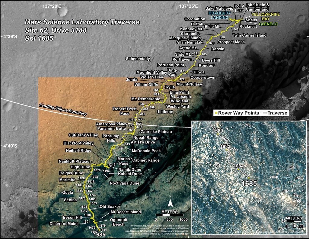
This map is periodically updated by the mission team as Curiosity drives on its way to the base of Mount Sharp.
Credit: NASA/JPL-Caltech
The base image from the map is from the High Resolution Imaging Science Experiment Camera (HiRISE) onboard NASA’s Mars Reconnaissance Orbiter.
Credit: NASA/JPL-CalTech/University of Arizona
A new map has been issued showing Curiosity’s traverse over Mars through Sol 1685.
This map shows the route driven by NASA’s Mars rover Curiosity through the 1685 Martian day, or sol, of the rover’s mission on Mars (May 03, 2017).
Numbering of the dots along the line indicate the sol number of each drive. North is up. The scale bar is 1 kilometer (~0.62 mile).
From Sol 1684 to Sol 1685, Curiosity had driven a straight line distance of about 60.01 feet (18.29 meters), bringing the rover’s total odometry for the mission to 10.12 miles (16.29 kilometers).

Credit: Lockheed Martin
Got an artistic pallet for the Red Planet? While placing humans on Mars is years off, what does the future hold for people surviving and thriving on that far flung world?
Here’s your chance to match your artistic bent with humankind’s future trajectory to Mars.
SMArt contest
The Mars Society is sponsoring a Student Mars Art (SMArt) Contest, inviting youth from around the world to depict the human future on Mars.
Young artists from grades 4 through 12 are invited to submit up to three works of art each, illustrating any part of our future on the Red Planet.
Mars art will consist of still images, which may be composed by traditional methods, such as pencil, charcoal, watercolors or paint, or by computerized means.
Deadline approaching
Artwork, for example, could spotlight the first landing, human field exploration, operations at an early Mars base, the building of the first Martian cities, terraforming the Red Planet and other related human settlement concepts.
The deadline for submissions: May 31, 2017, 5:00 pm, Mountain Standard Time (MST).

Credit: NASA
Categories
The SMArt Contest will be divided into three categories: Upper Elementary (grades 4-6), Junior High (grades 7-9), and High School (Grades 10-12).
Cash prizes of $1,000, $500 and $250, as well as trophies, will be given out to the first, second and third place winners of each section.
There will also be certificates of honorable mention for those artists who don’t finish in the top three, but whose work is nevertheless judged to be particularly meritorious.
Winning works
The winning works of art will be posted on the Mars Society web site and may also be published as part of a special book about Mars art.
Credit: Mars Society
Winners will also be invited to come to the 20th Annual International Mars Society Convention at the University of California, Irvine September 7-10, 2017 to display and discuss their art.
NOTE: Works of art must be submitted via a special online form:
http://nextgen.marssociety.org/mars-art in either PDF or JPEG format with a 10 MB limit per image.
By submitting art to the contest, participating students grant the Mars Society non-exclusive rights to publish the images on its web site or in Kindle paper book form.
All questions about the Mars Society’s SMArt Contest can be submitted to: Marsart@marssociety.org

Test bedding 3D manufacturing onboard the International Space Station.
Credit: NASA
A way to launch tiny, postage stamp-sized satellites called “Femtosatellites” is the winning design of an International Space Station Design Challenge.
The Femtosatellite launcher idea was chosen from 242 entries, and then digitally transmitted to the ISS where it was 3D-printed on April 3 by Made In Space’s Additive Manufacturing Facility (AMF) – the first commercially available off-world manufacturing service.
Mouser Electronics Inc. and inventor Grant Imahara today released official footage (below) of the winning design.
Last-minute modifications
“Mouser brought together engineers, students and makers from around the world in this exciting design challenge. All the designs were excellent, but in the end there was one design that stood above the rest,” said Glenn Smith, President and CEO of Texas-based Mouser Electronics, underscoring engineer Andy Filo’s winning design.
Made In Space and Filo made last-minute modifications after the ISS received the original design, rounding the handle to increase usability and comfort and further editing the design to increase printing speed.
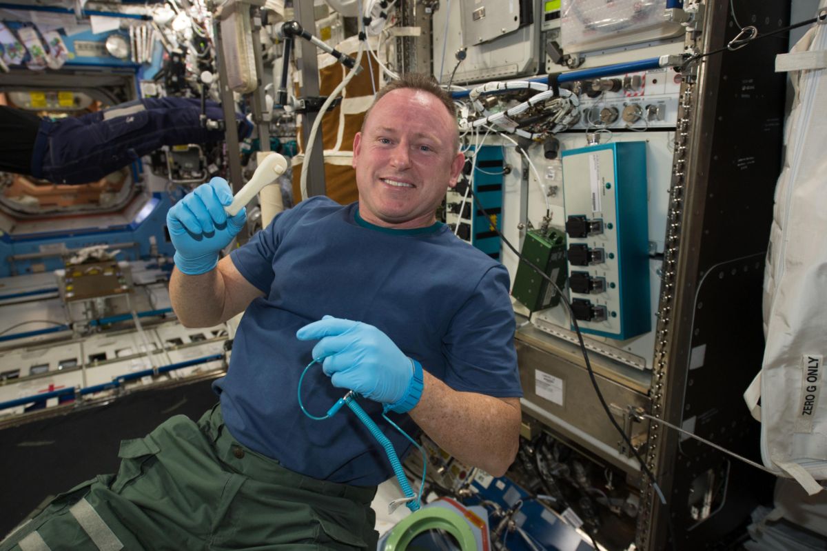
Ratcheting up use of 3D printing onboard the International Space Station. NASA Astronaut Barry (Butch) Wilmore holds a 3-D printed ratchet wrench from the new 3-D printer aboard the International Space Station. The printer completed the first phase of a NASA technology demonstration by printing a tool with a design file that was transmitted from the ground to the printer.
Credit: NASA
Missions and applications
Femtosatellites weigh less than 100 grams and researchers can use them for a variety of missions and applications, including monitoring disasters, cosmic rays and coronal events, according to a Mouser statement.
Mouser suppliers, Amphenol and Intel®, were co-sponsors of the space station design challenge, and also partnered with the Institute of Electrical and Electronics Engineers, Made In Space and MacroFab.
To video view this winning design, go to:
https://www.youtube.com/watch?v=-3-c0eJS4-Y&feature=youtu.be
Also, take a look at this video:
https://www.youtube.com/watch?v=c_3TangcGnM&feature=youtu.be

Mars true-color globe showing Terra Meridiani.
Credits: NASA/Greg Shirah
An international flotilla of new spacecraft — orbiters and landers — is slated to arrive at Mars in 2021, creating an unprecedented telecommunications challenge for NASA’s Deep Space Network (DSN).
These spacecraft all need to communicate with Earth en route to Mars, requiring large amounts of telemetry and tracking after launch and then on approach to the red planet. The sheer number of Mars-bound craft, launched by multiple nations, may stress NASA’s ground tracking network and capabilities of international partners.
For more information, please go to my new SpaceNews story at:

Credit: NASA, ESA, and the Hubble Heritage Team (STScI/AURA)
Acknowledgement: William Blair (Johns Hopkins University)
Here on Earth, researchers are on the lookout for microbial or, at best, unintelligent life.
But finding leftover technological artifacts by prior technological, perhaps spacefaring, species could be easier to locate.
Be prepared to detect unambiguous “technosignatures” is the advice of Jason Wright at the Pennsylvania State University’s Department of Astronomy & Astrophysics and Center for Exoplanets and Habitable Worlds.
Archeology of space
“While all geological records of prior indigenous technological species might be long destroyed, if the species were spacefaring there may be technological artifacts to be found throughout the Solar system,” Wright explains in a recent research paper, now in the production phase after being accepted for publication in the International Journal of Astrobiology.

Outward bound Voyager records with photos, messages, sounds.
Credit: NASA
Indeed, technosignatures could be in the form of artifacts beneath the surface of Mars, the rocky moons and asteroids, or in orbit in the outer Solar System where they could be discoverable.
“Such discoveries might occur using the tools of the burgeoning field of the archeology of space, which includes searching for, finding, and interpreting human artifacts in space,” Wright adds. “Such work includes the rediscovery and identification of lost probes and other space-borne human artifacts either for forensic purposes, or even accidentally.”
Buried structures
Wright suggests that more likely is revealing traces of buried structures or other artifacts via imagery and subsurface radar used to study the geology of planetary surfaces.
“Photometry and spectra of asteroids, comets, and Kuiper Belt Objects might reveal albedo, shape, rotational, compositional, or other anomalies because the targets host, or are, artifacts,” Wright explains.
Mars true-color globe showing Terra Meridiani.
Credits: NASA/Greg Shirah
The origins and possible locations for technosignatures of a prior indigenous technological species, Wright says, might be found on ancient Earth or another body, such as a pre-greenhouse Venus or a wet Mars of long ago.
Unambiguous technosignatures
“Remaining indigenous technosignatures might be expected to be extremely old, limiting the places they might still be found…beneath the surfaces of Mars and the Moon, or in the outer Solar System,” Wright suggests.
“The question is not how long the past we might be able to detect the fossil remains of the species — we don’t know how to measure intelligence reliably from fossils of bones — but to detect unambiguous technosignatures,” he writes.
Wright’s research was partially supported by Breakthrough Listen, part of the Breakthrough Initiatives sponsored by the Breakthrough Prize Foundation.
For the full research paper, go to Prior Indigenous Technological Species at:

U.S. Senator Ted Cruz (R-Texas) chaired on April 26th the first of a series of planned hearings to explore the reopening of the American frontier in space.
The hearing was titled “Reopening the American Frontier: Reducing the Regulatory Barriers and Expanding American Free Enterprise in Space,” and examined the U.S. Commercial Space Launch Competitiveness Act signed into law in November 2015, potential regulatory barriers to address in future legislation, and ways to expand commercial opportunities for American firms in space.

Space entrepreneur, Robert Bigelow, explains his expansive plans for space.
Credit: Space Foundation
Four witnesses testified at the hearing, including:
- Robert Bigelow, founder, Bigelow Aerospace
- Rob Meyerson, President, Blue Origin
- George Whitesides, CEO, Galactic Ventures
- Andrew Rush, CEO, Made in Space
Investment and innovation
According to Senator Cruz, Congress needs to work to ensure that investment and innovation within the commercial space sector isn’t effectively chilled by obsolete regulations or overly burdensome requirements that may not naturally apply to new business models.

Virgin Spaceship Unity is unveiled in Mojave, California February 19th, 2016. VSS Unity is the first vehicle to be manufactured by The Spaceship Company, Virgin Galactic’s wholly owned manufacturing arm, and is the second vehicle of its design ever constructed. VSS Unity was unveiled in FAITH (Final Assembly Integration Test Hangar), the Mojave-based home of manufacturing and testing for Virgin Galactic’s human space flight program.
Credit: Mark Greenberg/Virgin Galactic
“As we look at the future of American free enterprise and settlement in space we should also thoroughly review of the United Nations’ Outer Space Treaty which was written and enacted during a different time and era in 1967. It’s important that Congress evaluate how a treaty that was enacted 50 years ago will impact new and innovative activity within space as well as potential settlement throughout the galaxy,” Cruz said.

Space entrepreneur, Jeff Bezos.
Credit: Blue Origin
“Finally, we would be remiss if we didn’t explore ways that the commercial space sector, academia and NASA can look to build upon current partnerships and create new ones that can advance human spaceflight, research and discovery,” Cruz said.
Testimony and video
Witness panel testimony is available at:
Robert Bigelow, Founder, Bigelow Aerospace
Rob Meyerson, President, Blue Origin
George Whitesides, CEO, Galactic Ventures
Andrew Rush, CEO, Made in Space
To video view the entire Cruz Hearing: “Expanding American Free Enterprise in Space,” go to:

Artist’s view of Space Launch System/Orion spacecraft on the launch pad.
Credit: NASA
A newly released U.S. Government Accountability Office (GAO) report has found that the countdown for the first exploration mission of the Space Launch System/Orion spacecraft is likely to face delay.
The GAO report issued last week notes that NASA is working towards a November 2018 launch date for the first test flight of its three related human space exploration programs: the Orion crew vehicle, the Space Launch System, and the Exploration Ground Systems.
However, the GAO found that all three programs face challenges and have little time or money set aside to address potential issues, a situation that will likely delay the launch date, the report explains.

Credit: NASA
No schedule reserve
“All three programs face unique challenges in completing development, and each has little to no schedule reserve remaining between now and the [Exploration Mission – 1] EM-1 date, meaning they will have to complete all remaining work with little margin for error for unexpected challenges that may arise.
To view the full GAO report to Congressional Committees — NASA Human Space Exploration: Delay Likely for First Exploration Mission — issued April 27, 2017/GAO-17-414, go to:
http://www.gao.gov/assets/690/684360.pdf

At their fingertips: Adult participants getting a feel for solar eclipses at a recent Vision Rehabilitation & Assistive Technology Expo.
Credit: David Hurd
The total eclipse of the sun this August that sweeps across the continental United States is an eye-catching celestial occurrence. But what about a coworker, friend or family member who is totally blind or visually impaired?
Over the last couple of decades, there has been notable work done by NASA, educators and the National Federation of the Blind to make space science accessible for all.
To memorialize the forthcoming total solar eclipse event, a tactile guide has been created. Tactile graphics provides an illustration of the interaction and alignment of the sun with the moon and the Earth. Along with the guide, associated activities clarify the nature of eclipses.
For more information, go to my new Space.com story at:
Braille Guide Gives Users a Feel for 2017 Solar Eclipse
http://www.space.com/36553-total-solar-eclipse-2017-braille-guide.html

Curiosity Front Hazcam Right B image taken on Sol 1680, April 28, 2017.
Credit: NASA/JPL-Caltech
The Curiosity Mars rover continues its exploration trek, wheeling past the 10 mile mark since landing in August 2012.
Now in Sol 1681, the robot accomplished a drive of almost 95 feet (29 meters). The rover parked at a site suitable for a busy plan full of contact science on the Murray formation, reports Michael Battalio, an atmospheric scientist at Texas A&M University.
Flagstone
The rover focused mainly on characterizing nearby flagstone — “Duck Brook Bridge” — like the typical Murray formation that was tan in color, and “Cliffside Bridge” and “Waterfall Bridge” that were more coarse-grained and gray, Battalio adds.
Curiosity’s Chemistry & Camera (ChemCam ) is on tap to observe all of those targets, and its Alpha Particle X-Ray Spectrometer (APXS) is to measure both Duck Brook Bridge and Waterfall Bridge, with a long integration on Duck Brook Bridge.
Mastcam observations by the robot are slated to support that targeted science in addition to obtaining mosaics of fine-scale laminations on the “Stanley Brook Bridge” contact and alternating layering on “Chasm Brook Bridge.”

Curiosity Mastcam Right image acquired on Sol 1680, April 28, 2017.
Credit: NASA/JPL-Caltech/MSSS
Wheel inspection
In the final targeted science block on Sol 1682, ChemCam will observe “Amphitheater Bridge” and nodule-rich “Cobblestone Bridge.”
A major component of the plan is the Mars Hand Lens Imager (MAHLI) full-wheel imaging that is periodically done to ascertain the state of the rover wheels.

Curiosity ChemCam Remote Micro-Imager photo acquired on Sol 1680, April 28, 2017.
Credit: NASA/JPL-Caltech/LANL
This wheel inspection is being done slightly earlier than usual in preparation for traction control driving. Finally, after a drive, ChemCam will perform an Autonomous Exploration for Gathering Increased Science System (AEGIS). That software provides automated targeting for remote sensing instruments on the Marsauto-software activity, and the usual post-drive imaging will be performed.
Search for clouds
Battalio notes that there’s a busy plan for a morning imaging suite in Sol 1683.
In the suite, Navcam will search for clouds looking both directly above (zenith movie) and across the horizon (supra-horizon movie). Mastcam will measure the amount of dust in the atmosphere in two directions: in the direction of the sun and towards the crater rim – called a line-of-sight (LOS) extinction.

Curiosity Navcam Left B image taken on Sol 1680, April 28, 2017.
Credit: NASA/JPL-Caltech
“Each of these measurements will be repeated in the afternoon to determine what, if any, diurnal changes occur,” Battalio reports. A 360 degree dust devil search looking towards Mt. Sharp will be captured on Sol 1681.
Finally, a Navcam LOS extinction measurement will be taken for comparison with Mastcam. Normal Rover Environmental Monitoring Station (REMS) and Radiation Assessment Detector (RAD) measurements as well as several Dynamic Albedo of Neutrons (DAN) passive measurements and one DAN active are in the plan.

