Author Archive

Mars 2020 rover is a first step in bringing back specimens from the Red Planet to Earth.
Credit: NASA/JPL
A new sweeping assessment from the National Academies regarding future space exploration planning has noted its concern about the aging infrastructure orbiting Mars, which is vital for communicating with the landers and rovers, on the surface of the Red Planet.
NASA currently operates Mars Odyssey, Mars Reconnaissance Orbiter (MRO), and Mars Atmosphere and Volatile Evolution mission (MAVEN) around Mars, all of which have exceeded their design lifetimes. In addition to performing science, these missions also provide vital telecommunications support with surface assets.

Old, but still on duty: Mars Reconnaissance Orbiter yields unmatched views of layered materials, gullies, channels, and other science targets and also characterizing possible future landing sites for robotic and human missions.
Credit: NASA
The loss of one or more of these spacecraft could make it difficult for NASA to support the return of samples from the surface of Mars, the report explains.
Technologically difficult
NASA’s Mars 2020 rover is to collect samples for eventual return to Earth, but the return portion of that effort will be technologically difficult. The committee concluded that the space agency’s Planetary Science Division’s Mars sample return technology development plan is on the right track, and endorsed its proposed “focused Mars sample return” strategy.
The report also notes that going forward beyond Mars 2020, NASA is focused entirely on sample return.

NASA Mars 2020 rover is designed to collect samples, store the specimens in tubes, then deposit the tubes on the surface for later pick-up.
Credit: NASA/ESA
“There is currently no vision for a program beyond sample return, either for scientific investigation or to prepare for future human exploration,” the report advises.
Wanted: strategic plan
NASA’s Mars Exploration Program “has not yet put forward a complete architecture and attendant strategic plan that addresses the long-term goals of Mars exploration and optimizes science return across the spectrum of past, current, and future missions,” the report states.

Credit: NASA
While Mars plans are evaluated, the Academies report looks at a wide array of planetary science missions, including investigation of Europa and other worlds, and the needed technological developments necessary to further NASA’s exploration agenda.
To read the entire report and recommendations — “Visions into Voyages for Planetary Sciences in the Decade 2013-2022: A Midterm Review” — go to:
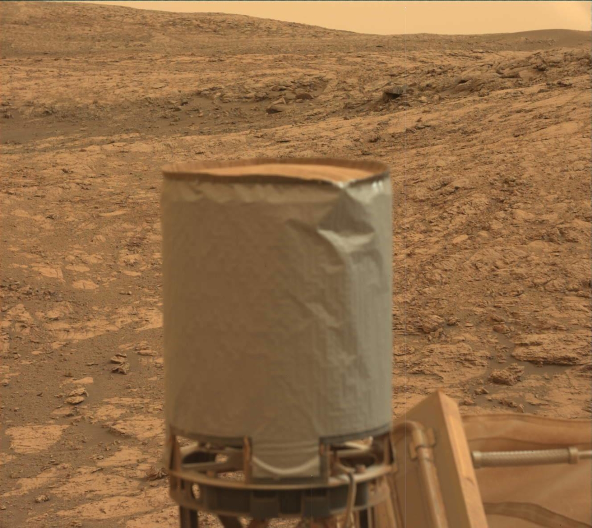
Curiosity Mastcam Left image acquired on Sol 2132, August 5, 2018.
Credit: NASA/JPL-Caltech/MSSS
Now in Sol 2134 Third time’s a charm? That’s the question posed by Rachel Kronyak, a planetary geologist at the University of Tennessee in Knoxville.
Curiosity Mastcam Left image acquired on Sol 2132, August 5, 2018.
Credit: NASA/JPL-Caltech/MSSS
“After a weekend full of contact science, remote science, and driving, Curiosity arrived at her next drill site within the Pettegrove Point member,” Kronyak adds. “Our previous two drilling attempts within the Pettegrove Point member haven’t been as successful as we’d have hoped; the rocks in this area are much harder than we’re used to – all the more reason to acquire and analyze a drill sample. We’re hopeful that our third drilling attempt does the trick!”
Drilling campaign
Curiosity planning for two sols was to kick off the robot’s drilling campaign.

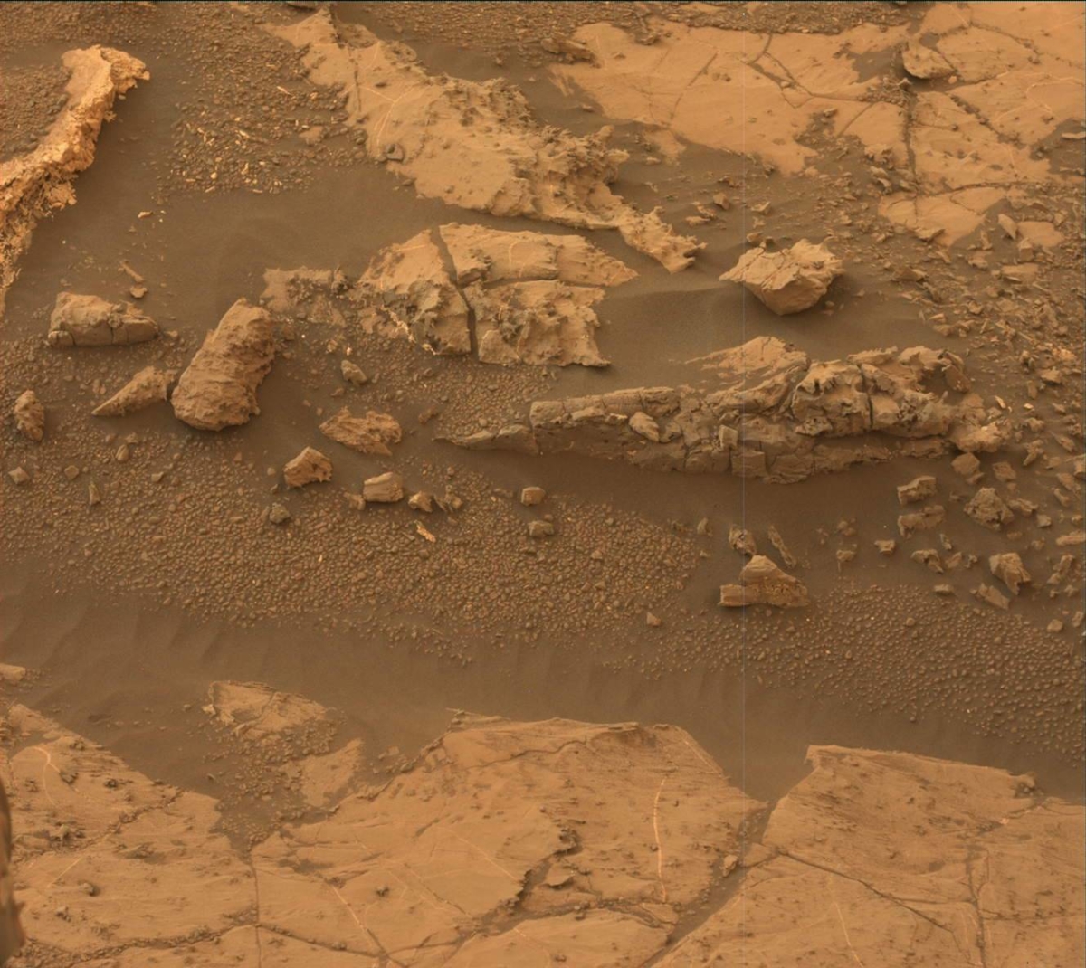
Curiosity Mars Hand Lens Imager (MAHLI) photo acquired on Sol 2132, August 5, 2018.
Credit: NASA/JPL-Caltech/MSSS
On Sol 2134, the schedule calls for performing triage contact science observations to document the new drill target which has been named “Stoer.”
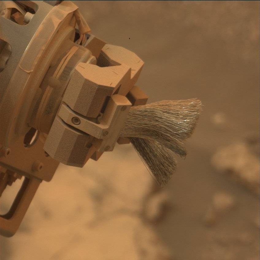
First the robot’s Dust Removal Tool (DRT) is to brush away some of the surface dust over Stoer before imaging it with the Mars Hand Lens Imager (MAHLI) camera and performing chemical analyses with the Alpha Particle X-Ray Spectrometer (APXS) instrument.

Curiosity Mars Hand Lens Imager (MAHLI) photo acquired on Sol 2132, August 5, 2018.
Credit: NASA/JPL-Caltech/MSSS
Stable rock?
“To prepare for drilling, we’ll then perform a ‘pre-load’ test, where we position the drill in contact with the Stoer rock surface and press down,” Kronyak points out. “This allows our mission engineers to verify that the rock is stable enough for drilling.”
Later in the afternoon, researchers will assess the Stoer area with a Mastcam mosaic and perform environmental monitoring observations with Navcam. They will then place the APXS instrument on Stoer overnight to get a long chemical observation.
Environmental observations
On Sol 2135, the script calls for a suite of remote science observations, including Rover Environmental Monitoring Station (REMS), Dynamic Albedo of Neutrons (DAN), and Navcam atmospheric observations.
After Curiosity’s robotic arm is moved out of the way, Kronyak explains that the rover is to perform two Chemistry and Camera (ChemCam) laser-induced breakdown spectroscopy (LIBS) analyses: one on Stoer, the other on the target “Strontian,” a nearby darker gray bedrock target.
“We’ll document both targets with Mastcam images and use additional camera filters to analyze Stoer; we call this observation a “multispectral” observation,” Kronyak notes.
That Sol ends with a Sample Analysis at Mars (SAM) Instrument Suite electrical baseline test (EBT), which is periodically performed to monitor the SAM instrument’s electrical functions.

Credit: NASA/JPL-Caltech/Univ. of Arizona
New road map
Meanwhile, a new Curiosity traverse map through Sol 2132 has been issued.
The map shows the route driven by NASA’s Mars rover Curiosity through the 2132 Martian day, or sol, of the rover’s mission on Mars (August 06, 2018).
Numbering of the dots along the line indicate the sol number of each drive. North is up. The scale bar is 1 kilometer (~0.62 mile).
From Sol 2128 to Sol 2132, Curiosity had driven a straight line distance of about 12.50 feet (3.81 meters), bringing the rover’s total odometry for the mission to 12.18 miles (19.60 kilometers).
The base image from the map is from the High Resolution Imaging Science Experiment Camera (HiRISE) in NASA’s Mars Reconnaissance Orbiter.

Curiosity Front Hazcam Left B image taken on Sol 2132, August 5, 2018.
Credit: NASA/JPL-Caltech
NASA’s Curiosity Mars rover is now performing Sol 2133 duties.
Curiosity is ready to bump to a new drill site in the Pettegrove Point member, but not before gathering many observations at the rover’s current location.

Curiosity Navcam Right B photo taken on Sol 2132, August 5, 2018.
Credit: NASA/JPL-Caltech
Reports Vivian Sun, a planetary geologist at NASA/JPL in Pasadena, California: “There are interesting color variations in today’s workspace, with grey, tan, and red gradients across the outcrop.”
The robot is set to document these color variations in detail with images from Mastcam and the Mars Hand Lens Imager (MAHLI) and chemical measurements from the Chemistry and Camera (ChemCam) and Alpha Particle X-Ray Spectrometer (APXS) instruments.

Curiosity Navcam Left B photo acquired on Sol 2132, August 5, 2018.
Credit: NASA/JPL-Caltech
“This is a lot of data to relay, but we expect downlinks from both the Mars Odyssey and the ExoMars Trace Gas Orbiter spacecrafts” – an action that was to take place over last weekend, Sun adds.
Laser shots
On Sol 2131, the geology theme group planned ChemCam measurements of the targets “Shiant Isles” and “Inchnadamph,” which are grey-toned rocks.
“The observation on Inchnadamph is especially interesting because ChemCam will shoot two sets of 150 laser shots into the rock to see if there are chemical variations with depth,” Sun points out. The APXS instrument will also make chemical measurements on a darker grey target “Mount Battock” and a lighter grey target “Scourie More,” in addition to a red target “Dobbs Linn” which will be brushed beforehand with the Dust Removal Tool (DRT).
Curiosity Mastcam Right image taken on Sol 2131, August 4, 2018.
Credit: NASA/JPL-Caltech/MSSS
All of these targets will be documented with high-resolution Mastcam and MAHLI images.
Color variations
On Sol 2132, Curiosity is scheduled to acquire a Mastcam multispectral observation of all these targets to enable a detailed assessment of these color variations. Mastcam will also image the “Bullers of Buchan” target, which is an outcrop that may expose layering and nodules. Curiosity will then drive a few meters to our drill site.
Sun reports that Sol 2133 is packed with three science blocks filled with activities from the environmental theme group: Mastcam tau and crater rim extinction observations, Navcam zenith, suprahorizon, and dust devil movies, and Navcam line of sight observations. Curiosity will also make ChemCam passive measurements and an APXS atmospheric measurement.
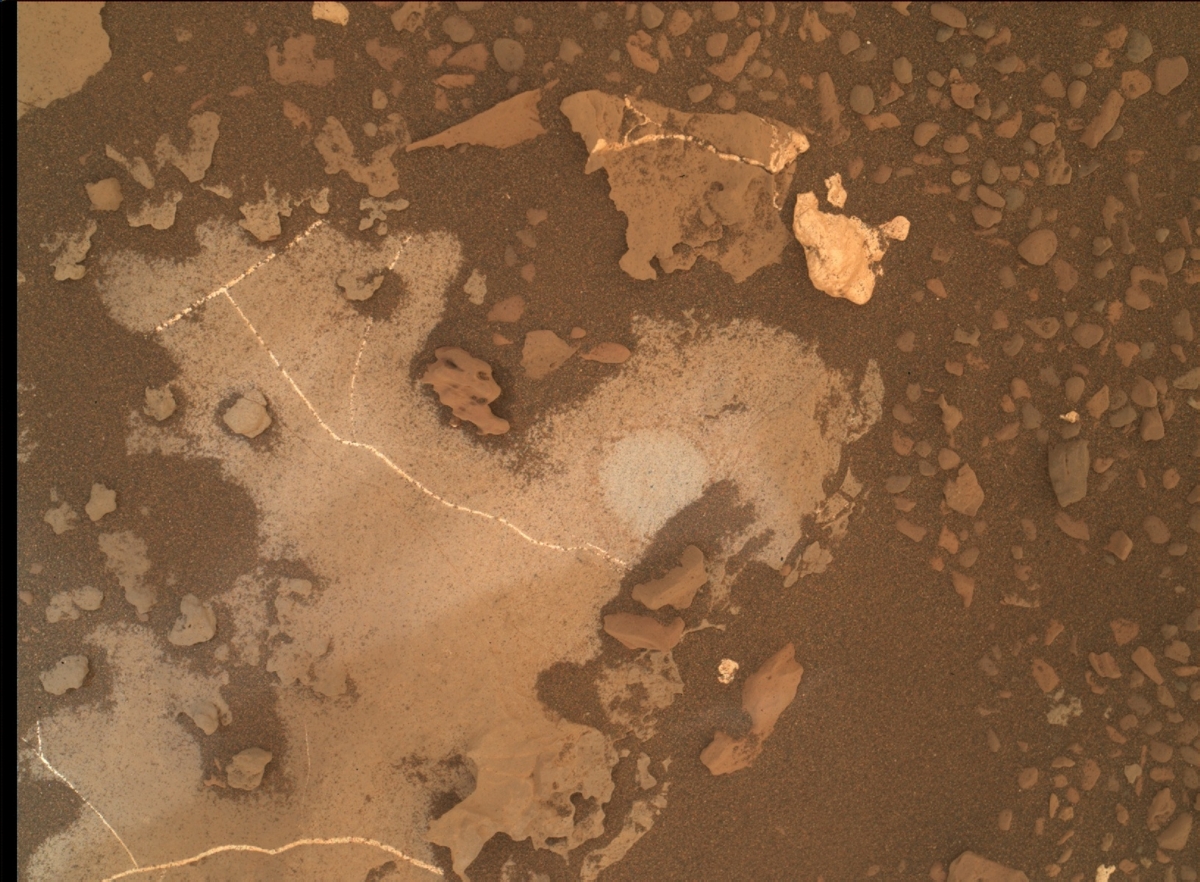
Curiosity Mars Hand Lens Imager (MAHLI) image produced on Sol 2132, August 5, 2018.
Credit: NASA/JPL-Caltech/MSSS
“All of these observations will help with our ongoing monitoring of the atmosphere as the dust storm settles,” Sun concludes. “After all of this, we look forward to seeing our drill workspace on Monday!”
Credit: Euroconsult
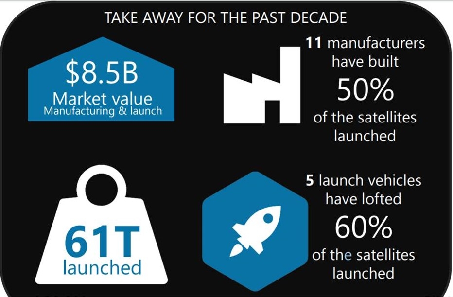
About 7,000 smallsats are due to be launched over the next ten years, i.e. a six-fold increase from the 1,200 units launched over the past decade. About 50 constellations, two of which are mega constellations, account for over 80% of the smallsat count.
That’s the news from Euroconsult, an independent, privately-owned firm.
Other revelations in their assessment include:
- By 2022, an average of 580 smallsats will be launched every year as a result of initial constellation deployment
- The average will then jump to 850 satellites per year on subsequent years up to 2027 because of the deployment of one mega constellation
- Smallsats are now able to perform missions that were only achievable in the past by satellites heavier that 500 kilograms
- Broadband communication is by far the largest application with close to 3,500 satellites expected from 2018 to 2027 (of which 92% for two mega constellations)
- Earth observation will almost triple, from 540 satellites in the past to 1,400 anticipated from 2018 to 2027. Three constellations alone plan to launch more than 800 satellites during this period, of which two are cubesat-based
- The 7,000 smallsats that are due to be launched over 2018-2027 are valued at $38 billion for satellite manufacturing and launch, almost a quintupling decade-to-decade
- The launch services of smallsats are expected to generate $16 billion in the next ten years i.e. strong growth over that of the past decade
For more information on this appraisal by Euroconsult, go to:
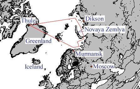
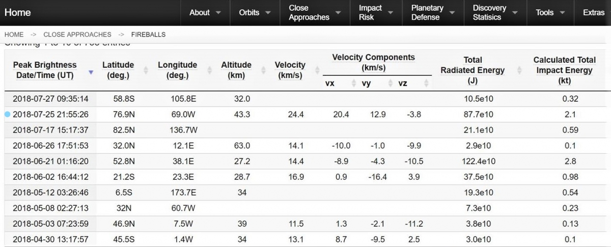
Report: Meteor made 2.1 kiloton explosion over Air Force Space Command Base, Thule, Greenland on July 25, 2018. The high-altitude explosion at 27 miles (43.3 kilometers) was detected by US Government sensors at an altitude of 43.3 km.
The Jet Propulsion Laboratory’s Center for Near Earth Object Studies lists the incident in its Fireball and Bolide Data section.
21st Space Wing
Thule Air Base is home to the 21st Space Wing’s global network of sensors providing missile warning, space surveillance and space control to North American Aerospace Defense Command and Air Force Space Command.
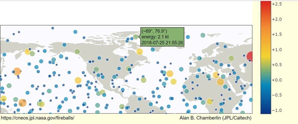
Credit: JPL Center for Near Earth Object Studies
Thule Air Base is the United States Department of Defense’s northernmost installation at (76 32′ North latitude, 68 50′ West longitude) located 750 miles north of the Arctic Circle, and 947 miles south of the North Pole on the northwest side of the island of Greenland. It is approximately 550 miles east of the North Magnetic Pole.
Go to this informative report by The Aviationist at:

Credit: Copenhagen Suborbitals
Copenhagen Suborbitals reports a successful August 4 flight of its suborbital Nexø II rocket, the most advanced rocket built and launched by the group so far.
Credit: Copenhagen Suborbitals
The launch took place from ESD139 in the Baltic Sea 35 kilometers off the coast of the Danish island Bornholm. The rocket lifted off from a sea-based launch platform.
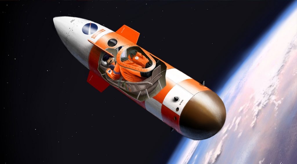
Spica: astronaut-carrying rocket
The Nexø rocket class is a technology demonstrator in advance of building a significantly bigger Spica rocket that will take an astronaut to the edge of space.
Credit: Copenhagen Suborbitals
Space is defined by the Kármán line at 100 km above Earth, so the plan is to fly a space capsule with an astronaut straight up to just over that altitude, from where it will free fall straight back and land by parachute in the sea.

Credit: Copenhagen Suborbitals
Go to this video of the launch at:
For more information on Copenhagen Suborbitals, go to:
![]()
The Congressional Research Service (CRS) has issued an overview on Iran’s Ballistic Missile and Space Launch Programs
As noted by the CRS report, Iran has been acquiring, developing, and testing its ballistic missile capabilities for decades. The United Nations Security Council in 2015 adopted resolution 2231, calling on, but not requiring, Iran to not develop nuclear-capable ballistic missiles and to halt other ballistic missile activity.
Nevertheless, Iran continues to invest in developing ballistic missiles and in building an extensive network of facilities, although missile inventory information is scarce.
Go to this informative August 1 CRS document at:
https://fas.org/sgp/crs/nuke/IF10938.pdf

Curiosity Mastcam Left image taken on Sol 2126, July 30, 2018.
Credit: NASA/JPL-Caltech/MSSS
NASA’s Curiosity Mars rover is now performing 2130 duties.
The robot is currently on its way to a potentially softer rock target to drill in the Pettegrove Point member of Vera Rubin Ridge, reports Lauren Edgar, a planetary geologist at the USGS in Flagstaff, Arizona.

Curiosity Navcam Left B image acquired on Sol 2129, August 2, 2018.
Credit: NASA/JPL-Caltech
Bedrock workspace
The geology theme group planned several autonomously targeted Autonomous Exploration for Gathering Increased Science (AEGIS) observations of bedrock in the workspace. In addition, plans called for producing a Mastcam mosaic of the workspace and a Navcam mosaic of the Chemistry and Camera (ChemCam) targetable region to prepare for targeting in the weekend plan.

Curiosity Mastcam Left image taken on Sol 2126, July 30, 2018.
Credit: NASA/JPL-Caltech/MSSS
The environmental theme group was also to perform two Mastcam tau and crater rim extinction observations, a Navcam line of sight and dust devil movie, and Navcam suprahorizon and zenith movies.
Dust storm assessment
“All of this great environmental monitoring data will help as we continue to assess the ongoing dust storm,” Edgar says.
“Looking ahead, we hope to proceed with science activities and driving in the weekend plan with the help of the Mars Odyssey spacecraft to relay data,” Edgar concludes.

Credit: NASA/JPL-Caltech/Univ. of Arizona
Road map
Meanwhile, a new Curiosity traverse map through Sol 2128 has been issued.
The map shows the route driven by NASA’s Mars rover Curiosity through the 2128 Martian day, or sol, of the rover’s mission on Mars (August 02, 2018).
Numbering of the dots along the line indicate the sol number of each drive. North is up. The scale bar is 1 kilometer (~0.62 mile).
From Sol 2126 to Sol 2128, Curiosity had driven a straight line distance of about 146.88 feet (44.77 meters), bringing the rover’s total odometry for the mission to 12.18 miles (19.60 kilometers).
The base image from the map is from the High Resolution Imaging Science Experiment Camera (HiRISE) in NASA’s Mars Reconnaissance Orbiter.

Credit: OMB
July 31, 2018 Memo from Mick Mulvaney, Director, Office of Management and Budget
FY 2020 Administration Research and Development Budget Priorities: American Space Exploration & Commercialization
“Research and innovation in space have a direct impact on Earth, generating advancements in our basic understanding of the universe and our own planet, and inspiring the next generation of scientists and engineers.

Credit: White House
Research investments should be focused on ensuring American leadership in space for long-duration spaceflight, in-space manufacturing, in-situ resource utilization, longterm cryogenic fuel storage and management, and advanced space-related power and propulsion capabilities.
Agencies should prioritize demonstrations and flight tests to ensure an industrial base for commercial activity in space and on celestial bodies.
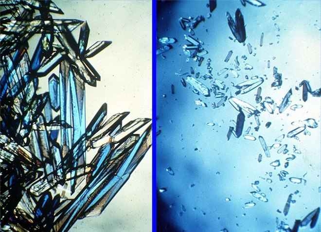
Protein crystals grown in microgravity.
Credit: NASA
One area of potential scientific and commercial importance is microgravity-related research that has the potential for near-term breakthroughs in biopharmaceuticals and materials science.
Finally, agencies should seek opportunities to work with advanced materials, additive manufacturing, optical communications, and machine learning-capabilities that have broad potential applications in space and on Earth.”
Credit: UNOOSA
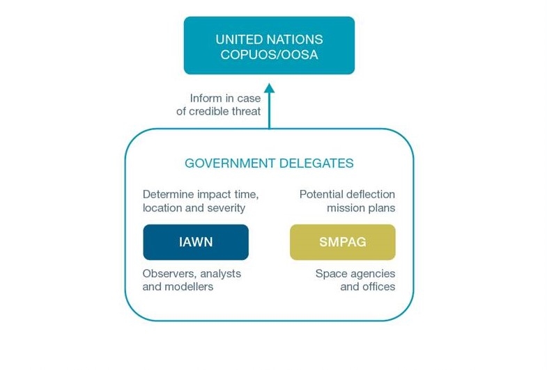
The United Nations Office for Outer Space Affairs has issued a document: “Near-Earth Objects and Planetary Defence.”
“Addressing such a hazard, including the identification of objects that pose a risk of impact, and planning a corresponding mitigation campaign, require cooperative action in the interest of public safety on the part of the global community,” explains Simonetta Di Pippo, Director of the United Nations Office for Outer Space Affairs in the document’s foreword.
Warning network
The Office supports and cooperates with two entities established in 2014: the International Asteroid Warning Network (IAWN) and the Space Mission Planning Advisory Group (SMPAG).
These two entities came into being through a series of recommendations for an international response to the risk of near-Earth object impact, endorsed by the United Nations Committee on the Peaceful Uses of Outer Space.
Credit: UNOOSA
Emergency response
The goal of planetary defense is to ensure that all countries, in particular developing nations with limited capacity for predicting and mitigating a Near Earth Object (NEO) impact, are aware of potential risks as well as to ensure effective emergency response and disaster management in the event of a NEO impact.
As this area is crucial to ensuring human security, the United Nations continues to facilitate the processes for developing an international response to a NEO-impact threat, with the Office for Outer Space Affairs playing an active role.
The report is available at:
http://www.unoosa.org/res/oosadoc/data/documents/2018/stspace/stspace73_0_html/st_space_073E.pdf

