Author Archive

Source: NASA Exoplanet and Exploration Program
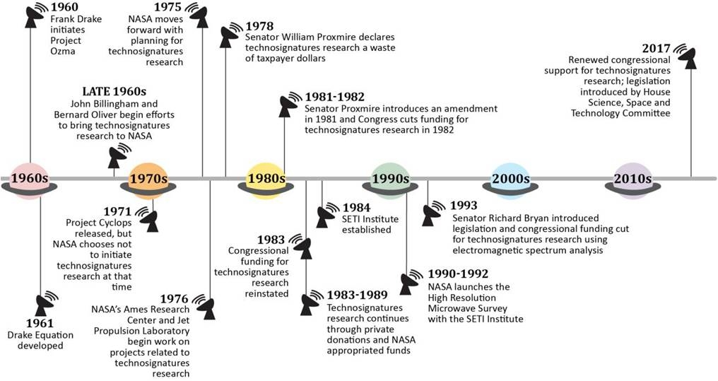
An audit of the SETI Institute has been performed by the NASA Office of Inspector General.
Over the past 25 years, NASA has, according to Agency officials, provided only three grants totaling $1.6 million for research associated with the direct search for extraterrestrial intelligent life through the use of electromagnetic signals, the OIG report explains.
“It is not clear whether this limited funding is simply because technosignatures research has not been an Agency priority or whether it is due to confusion related to a 1-year congressional prohibition on such research in 1993. The broader scientific community has expressed interest in the search for extraterrestrial intelligent life in the past, as did a House of Representatives NASA authorization bill voted out of Committee in April 2018.”
Technosignatures 101
As noted in the report, technosignatures research is a collective term for scientific searches for intelligent extraterrestrial life and includes—but is not limited to—monitoring electromagnetic radiation for signs of transmissions from civilizations on other planets.
The SETI Institute is only one organization within a broader community of practitioners that conduct technosignatures research. Moreover, the Institute conducts wide-ranging scientific research in multiple disciplines that goes well beyond the search for intelligent life outside of Earth.
Source: NASA OIG presentation of information from “Searching for Good Science: The Cancellation of NASA’s SETI Program,” written by Stephen J. Garber of the NASA History Office and published in the Journal of The British Interplanetary Society, Vol. 52 (1999).
Strong partnership
The upshot from the audit: “The research conducted by the SETI Institute through its 85 awards with NASA has played an important role in advancing understanding of stars, planets, planetary satellites, and astrobiology, all of which reflect the Agency’s science goals and objectives.”
The reports further states: “We found that NASA followed its policies and federal guidelines when it solicited and selected the SETI Institute for these awards, and in turn, the Institute properly accounted for expenditures and complied with federal requirements. As a result, NASA and the Institute have forged a strong partnership and produced valuable data and research benefitting the scientific community.”
To review this interesting and informative document, go to:

Credit: PSI
Taking the plunge to map potential water resources on Mars is the SWIM project.
The Subsurface Water Ice Mapping (SWIM) effort is cross-cutting. Results can help the ongoing search for signs of life on Mars, as well as identify future landing sites for human expeditions.
Mapping products
SWIM is a project led by Planetary Science Institute (PSI) scientists in Tucson, Arizona.
“The goal of the SWIM project is to provide a set of mapping products using existing spacecraft data that delineate subsurface ice in the mid-latitudes of Mars,” said Gareth Morgan, a leader of the PSI SWIM team.

The Subsurface Water Ice Mapping project is currently studying large expanses of the northern hemisphere of Mars to identify potential shallow water-ice resources. Work is focused in the four outlined regions, all of which exhibit evidence of ice such as Lineated Valley Fill (LVF) and Lobate Debris Aprons (LDA).
Credit: Gareth Morgan
The SWIM team is producing new maps of the likelihood of subsurface ice deposits over such locales as “Arcadia Planitia” and other low elevation regions across the Martian Northern Hemisphere: “Acidalia,” “Onilus,” and “Utopia.”
To chart these regions a combination of radar, thermal, neutron, altimetry, and image data from several Mars-orbiting spacecraft will be used.
Radar returns
The team is also employing newly developed techniques that include using radar returns to infer the presence of ice within the top 16 feet (5 meters) of the crust and applying advanced radar processing to improve resolution at depth and to estimate the purity of ice in the subsurface.
“Water ice will be a critical resource for human explorers on Mars, not only for life support but also for generating fuel to power equipment on the ground and rockets for the return journey to Earth,” said PSI’s SWIM team leader, Nathaniel Putzig.

Candidate SpaceX Red Dragon landing spot – Arcadia Planitia, a smooth plain on Mars that appears to have large quantities of ice near the surface.
Credit: University of Arizona/Mars Reconnaissance Orbiter’s High Resolution Imaging Science Experiment (HiRISE).
“Maps that identify the nature and availability of potential water resources will help determine where humanity will establish its first outposts on Mars,” Putzig added in a PSI press statement.
SpaceX landing site?
Interestingly, Arcadia Planitia has been identified by SpaceX as a potential landing site for the firm’s proposed Red Dragon program. Paul Wooster, lead in the technical development of SpaceX’s Mars architecture and vehicles — including both Red Dragon and human-scale systems — has said that choosing a site is driven by the quantity of water the firm is looking for…and that’s thousands of tons.

SpaceX Red Dragon on Mars.
Credit: SpaceX
One such Red Dragon touchdown place that is “quite promising” Wooster has stated in the past, is Arcadia Planitia, a smooth plain on Mars that appears to have large quantities of ice near the surface.
Meanwhile, results from each of the SWIM team study regions will be integrated into a single northern hemisphere ice consistency map by the end of April 2019. Funding for this project came to PSI from the Caltech Jet Propulsion Laboratory, supported by NASA.
For more information on the SWIM project, go to:

A frame-by-frame showing how gravity causes asteroid fragments to reaccumulate in the hours following impact. Credit: Charles El Mir/Johns Hopkins University
Incoming asteroids may be harder to break than scientists previously thought, finds a Johns Hopkins study that used a new understanding of rock fracture and a new computer modeling method to simulate asteroid collisions.
The findings, to be published in the March 15 print issue of Icarus, can aid in the creation of asteroid impact and deflection strategies, increase understanding of solar system formation, and help design asteroid mining efforts.

Business plan for asteroid mining.
Credit: Joel Sercel/ICS Associates Inc. and TransAstra
Tonge-Ramesh model
This new work was led by El Mir, a recent PhD graduate from the Johns Hopkins University’s Department of Mechanical Engineering and his colleagues, K.T. Ramesh, director of the Hopkins Extreme Materials Institute and Derek Richardson, professor of astronomy at the University of Maryland.
The researchers entered the same scenario into a new computer model called the Tonge-Ramesh model, which accounts for the more detailed, smaller-scale processes that occur during an asteroid collision. Previous models did not properly account for the limited speed of cracks in the asteroids.
End result
“Our question was, how much energy does it take to actually destroy an asteroid and break it into pieces?” says El Mir.
The research team found that the end result of their impact work was not just a “rubble pile” – a collection of weak fragments loosely held together by gravity.
Instead, the impacted asteroid retained significant strength because it had not cracked completely, indicating that more energy would be needed to destroy asteroids.
Meanwhile, the damaged fragments were now redistributed over the large core, providing guidance to those who might want to mine asteroids during future space ventures.

Chelyabinsk sky rendering is a reconstruction of the asteroid that exploded over Chelyabinsk, Russia on Feb. 15, 2013. Scientific study of the airburst has provided information about the origin, trajectory and power of the explosion. This simulation of the Chelyabinsk meteor explosion by Mark Boslough was rendered by Brad Carvey using the CTH code on Sandia National Laboratories’ Red Sky supercomputer. Andrea Carvey composited the wireframe tail. Photo by Olga Kruglova.
Credit: Sandia National Laboratories.
When the time comes
“We are impacted fairly often by small asteroids, such as in the Chelyabinsk event a few years ago,” says Ramesh in a Hopkins Extreme Materials Institute press release. The Institute is located in Baltimore, Maryland.
“It is only a matter of time before these questions go from being academic to defining our response to a major threat,” Ramesh adds. “We need to have a good idea of what we should do when that time comes – and scientific efforts like this one are critical to help us make those decisions.”
For a visual view of this new work, go to:
The first phase of a new asteroid collision model, which shows the processes that begin immediately after an asteroid is hit—processes that occur within fractions of a second.
https://www.youtube.com/watch?time_continue=7&v=Vt_xwQYafOY
The second phase of a new asteroid collision model, which shows the effect gravity has on the pieces that fly off an asteroid’s surface after impact. This phase occurs over many hours.
https://www.youtube.com/watch?time_continue=12&v=ZjBgljnCtWk
To access the Icarus paper — A new hybrid framework for simulating hypervelocity asteroid impacts and gravitational reaccumulation – go to:
https://www.sciencedirect.com/science/article/abs/pii/S001910351830349X
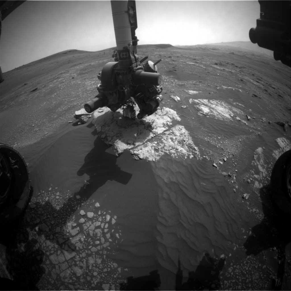
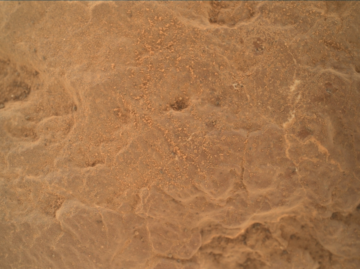
Curiosity Front Hazcam Left A photo acquired on Sol 2338, March 5, 2019.
Credit: NASA/JPL-Caltech
NASA’s Curiosity Mars rover is now engaged in Sol 2339 science tasks.
The robot has performed a full menu of science activities, finishing observations at the “Midland Valley” outcrop, reports Rachel Kronyak, a planetary geologist at the University of Tennessee in Knoxville.
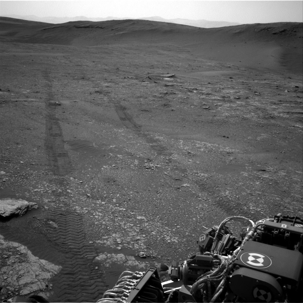
Curiosity Navcam Left A image taken on Sol 2338, March 5, 2019.
Credit: NASA/JPL-Caltech
Workspace rock targets
Curiosity has primarily used its Mastcam and Chemistry and Camera (ChemCam) instruments to take a closer look at some interesting rock targets in its workspace.
Planned Sol 2338 activities included a Mastcam mosaic looking ahead of the rover, where the team identified an interesting area of fractured bedrock, naming this target area “Longhope.”
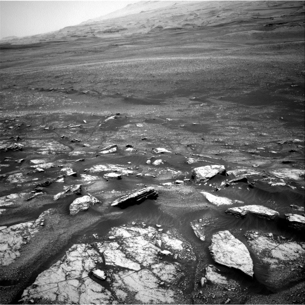
Curiosity Navcam Left A image taken on Sol 2338, March 5, 2019.
Credit: NASA/JPL-Caltech
New parking spot
After that, the plan calls for use of the ChemCam laser to analyze rock targets “Miller” and “Cuttyhill,” then take multispectral Mastcam images of targets Cuttyhill and another interesting rock named “Leslie,” Kronyak explains.
“After our science observations, we’ll hit the dusty trail and drive towards our next bedrock-rich destination, an area called ‘Milltimber.’ To finish up the plan, we’ll take some post-drive images to survey our new parking spot and prepare for more science observations! We’ll also perform an atmosphere monitoring activity with Navcam to look for dust devils,” Kronyak adds.
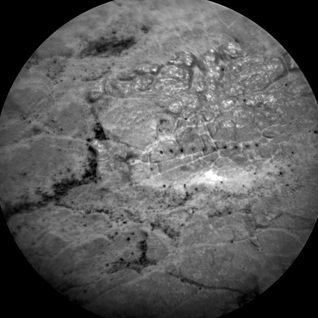
Curosity Mars Hand Lens Imager (MAHLI) image produced on Sol 2333, February 28, 2019.
Credit: NASA/JPL-Caltech/MSSS
Laser zapping. Curiosity ChemCam Remote Micro-Imager photo taken on Sol 2339, March 6, 2019.
Credit: NASA/JPL-Caltech/LANL
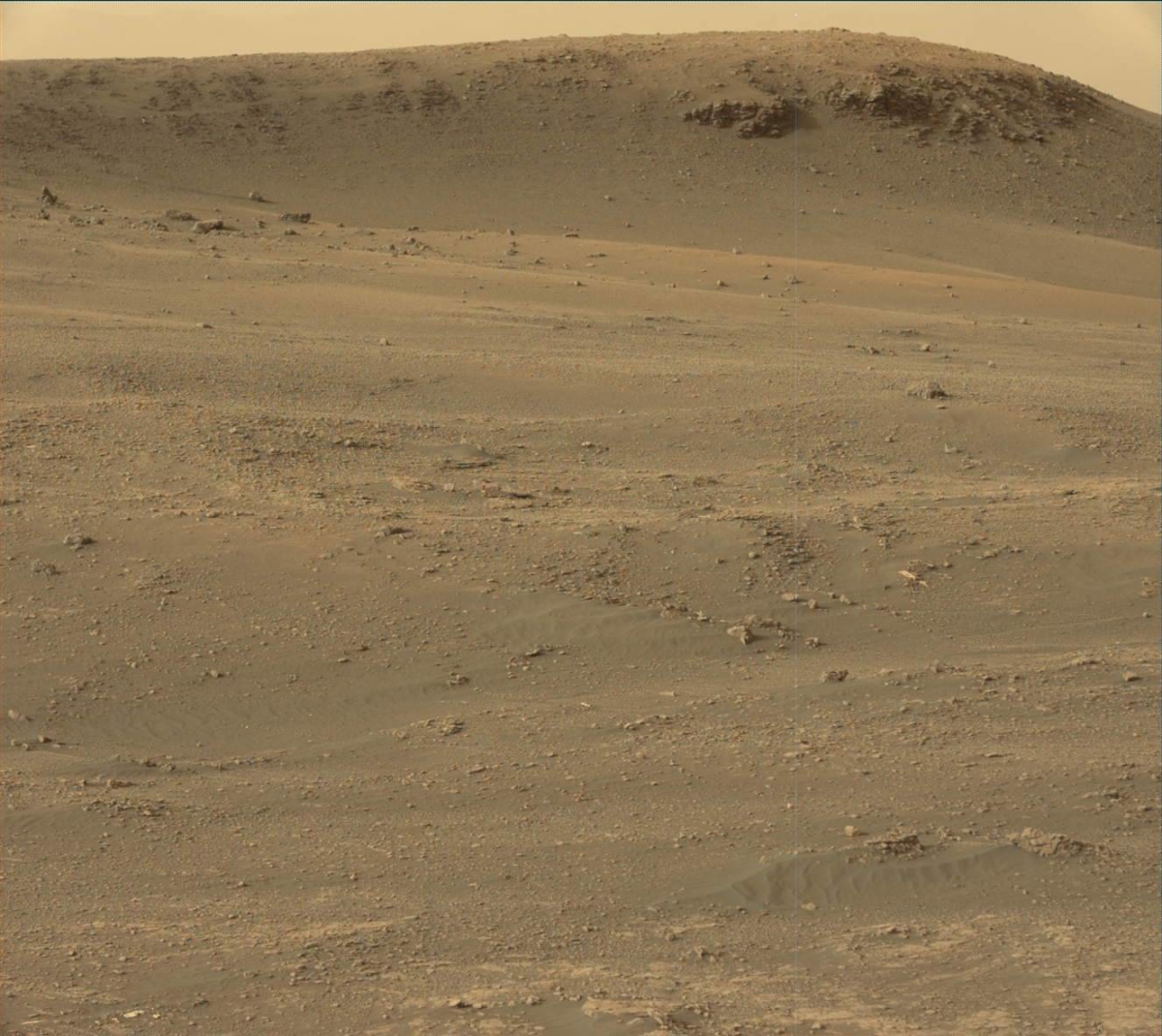
Curiosity Mastcam Left photo acquired on Sol 2320, February 15, 2019.
Credit: NASA/JPL-Caltech/MSSS

Farside photo from Yutu-2 rover.
Credit: CNSA/CLEP
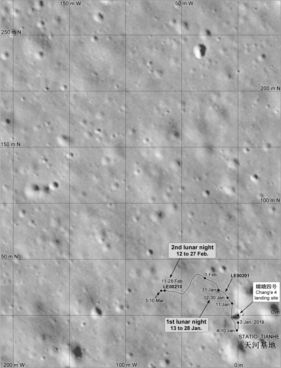
China’s Yutu-2 farside lunar rover has traveled about 416 feet (127) meters within the Von Kármán crater in the South Pole-Aitken (SPA) Basin.
Yutu-2, or Jade Rabbit-2, is now taking a “noon break” as the temperature on the lunar surface rises extremely high, reports China’s Xinhua’s news service. The robot is slated to resume work on March 10 and switch to its dormant mode on March 13, according to the Lunar Exploration and Space Program Center of the China National Space Administration.
The Yutu-2, or Jade Rabbit-2 rover, was sent to the farside of the Moon on Jan. 3 as part of the Chang’e-4 mission.

On a roll. China’s Yutu-2 rover on the Moon’s farside.
Credit: CNSA/CLEP
Nearby stones
Experts from the National Space Science Center (NSSC) under the Chinese Academy of Sciences (CAS) stated that the rover has conducted scientific detection on its tracks and nearby stones. The largest stone detected has a diameter of about 20 centimeters, and the rover came as close as 4 feet (1.2 meters) to this stone.
Researchers are engaged in understanding the origin of the stones, whether they are aboriginal on the Moon, or meteorites from outer space. If they are aboriginal, what is the physical process of their formation?

NASA’s Lunar Reconnaissance Orbiter (LRO) captured China’s Chang’e-4 farside lander/rover.
Image shows lander (near tip of left arrow) and rover (near tip of right arrow) nestled among craters on the floor of Von Kármán crater.
Credit: NASA/GSFC/Arizona State University
Bombardment clues?
Ping Jinsong, a researcher with the National Astronomical Observatories under CAS, said that the rocks on the lunar surface might be sputtered body as a result of meteorite impact.
Scientists have found evidence indicating a heavy asteroid bombardment event in the solar system around 3.9 billion years ago. And the SPA Basin might be an impact from that period. The exploration might offer clues as to why the bombardment occurred, said Zou Yongliao, director of the lunar and deep space exploration division of CAS, according to the Xinhua news story.

Pre-launch prepping of Yutu-2 rover.
Credit: China Central Television (CCTV)/China National Space Administration (CNSA)/Screengrab/Inside Outer Space
Difficult driving
From the images sent back from Chang’e-4, scientists found the area surrounding the probe dotted with craters of different sizes, and it’s very difficult for the rover to drive in the region.
According to the rover’s designers from the China Academy of Space Technology, the 298-pound (135-kilograms) — the lightest rover ever sent to the Moon — the machine is capable of avoiding some obstacles. If there are obstacles in front of it, it can stop and plan a new route on its own. It can also climb some slopes and cross rocky terrain.
Credit: Philip Stooke

Credit: Zero Gravity Corporation
You want your own set of Moon legs?
Zero Gravity Corporation (ZERO-G) will partner with Space Florida to take fans onboard a special-purpose aircraft to demonstrate the feeling of exploring the Moon’s surface.
This parabolic flight will recreate lunar gravity and allow riders to float with the ease of carrying one-sixth their normal body weight.
Arch-etypes
ZERO-G pilots will perform a series of parabolic arcs while flying in a FAA designated airspace.
At the top of each arc, flyers will soar through the plane in a floating playground, perform effortless tricks and flips and share a world known only by a small fraction of the population.
Love the Moon, but Mars is in your sights? The flight will also include several zero gravity and Martian gravity parabolas.

Credit: Zero Gravity Corporation
Elite group
Taking off July 20 (Apollo 11’s Eagle landing day on the Moon) from Space Florida’s Launch and Landing Facility (formerly the NASA Shuttle Landing Facility) at the Cape Canaveral Spaceport, ZERO-G is offering Apollo enthusiasts the chance to join an elite group of individuals who have experienced weightlessness high above the Earth’s surface.
Zero Gravity Corporation is a privately held space entertainment and tourism company dedicated to make the excitement and adventure of space accessible to the public.
A limited number of tickets for this exclusive flight are now on sale to the general public. For ticket and flight information, go to:

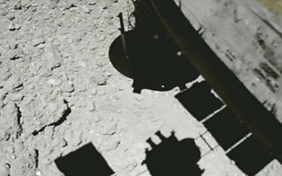
Hayabusa2 image captured near the touchdown site roughly a minute after touchdown. The photograph was taken at roughly 80 feet (25 meters) with the Optical Navigation Camera – Wide angle (ONC-W1) on February 22, 2019 (JST).
Credit: JAXA, University of Tokyo, Kochi University, Rikkyo University, Nagoya University, Chiba Institute of Technology, Meiji University, University of Aizu, AIST
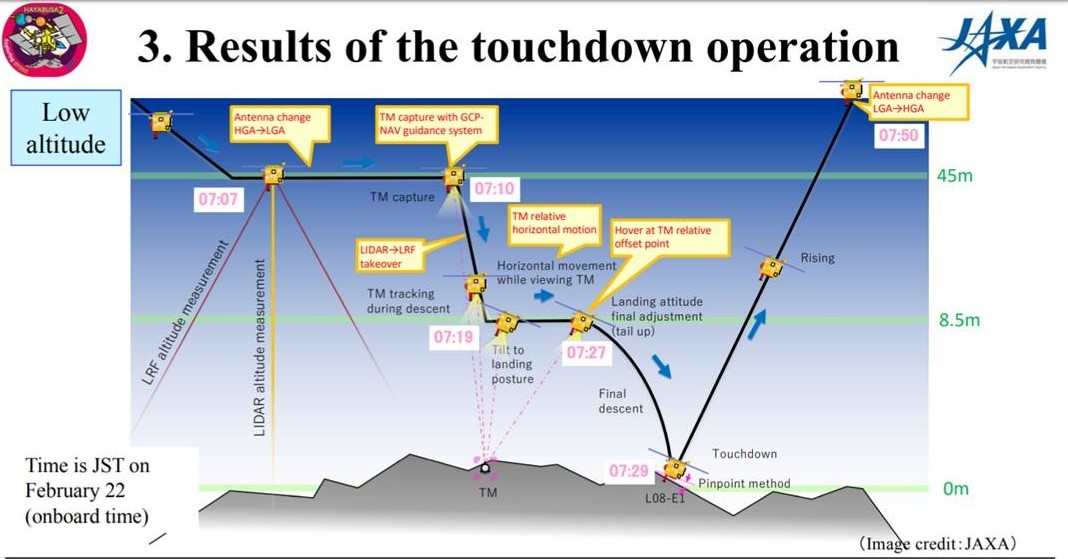
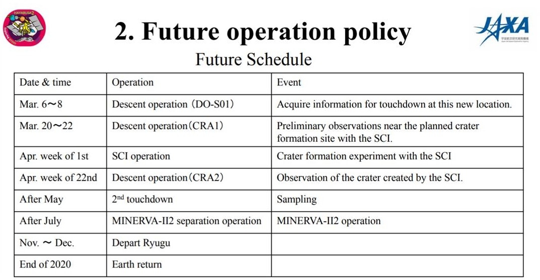
Japan’s Hayabusa2 made a successful first touchdown and sampling operation February 22, 2019 (JST) at asteroid Ryugu. Mission planners are moving forward with the next event – the experiment to form an artificial crater using the Small Carry-on Impactor (SCI).
Credit: JAXA
A second touchdown will be done inside or outside the artificial crater formed with the SCI. There is a high probability that a third touchdown will not be performed.
Sufficient sample collected
A Japan Aerospace Exploration Agency (JAXA) Hayabusa2 Project media briefing on March 5th reports that the first touchdown has been judged to have collected a “sufficient sample.”
During the first touchdown, some of the optical sensors in the spacecraft base received a reduced amount of light. There is no problem during normal operations, but this effect means that careful preliminary investigation is necessary ahead of touchdown operations. As this preparation takes time, the SCI operation will be performed first.
Credit: JAXA
After Hayabusa2 ascended following the touchdown, and checking the telemetry on the ground, it was confirmed from the status and temperature change of the projector that the spacecraft’s bullet-like projectile had indeed fired.
Touchdown point
A nickname for the spacecraft’s touchdown point has been selected: “Tamatebako.”
While not an official name it was the most popular suggestion when requesting names from Project Members. In the story of Urashima Taro (where Ryugu takes its name), smoke emerges from the tamatebako (treasure box) which is like the ejected asteroid material flying upwards at touchdown. Also because this is the point where the sample (= treasure of Ryugu) was collected.
Credit: JAXA
Initial impressions
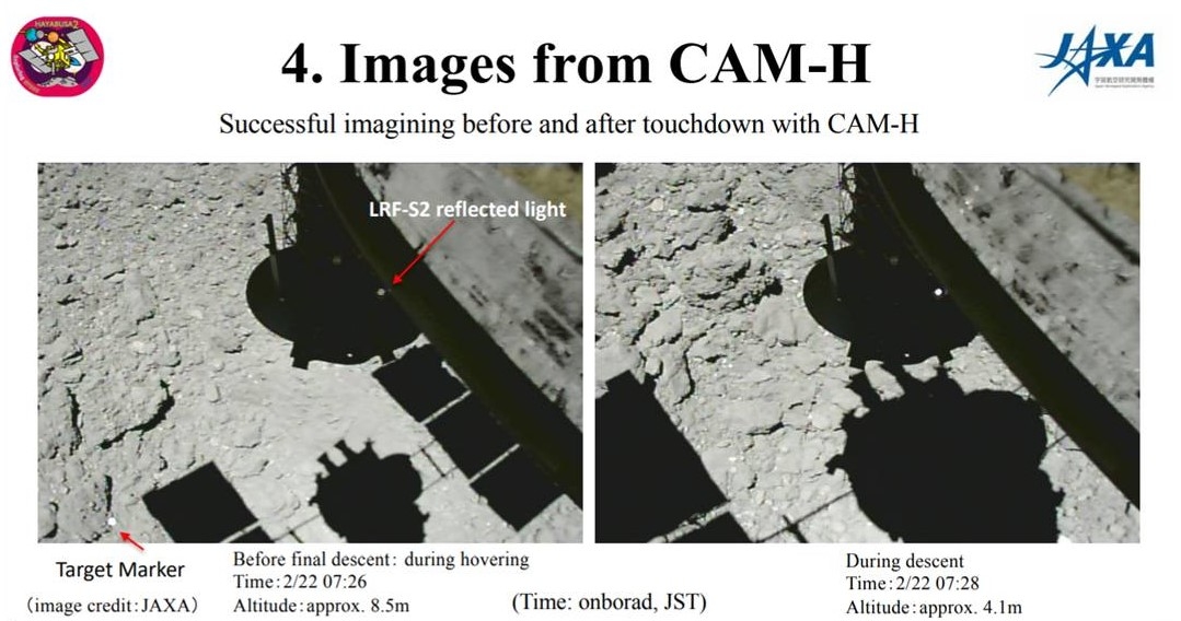
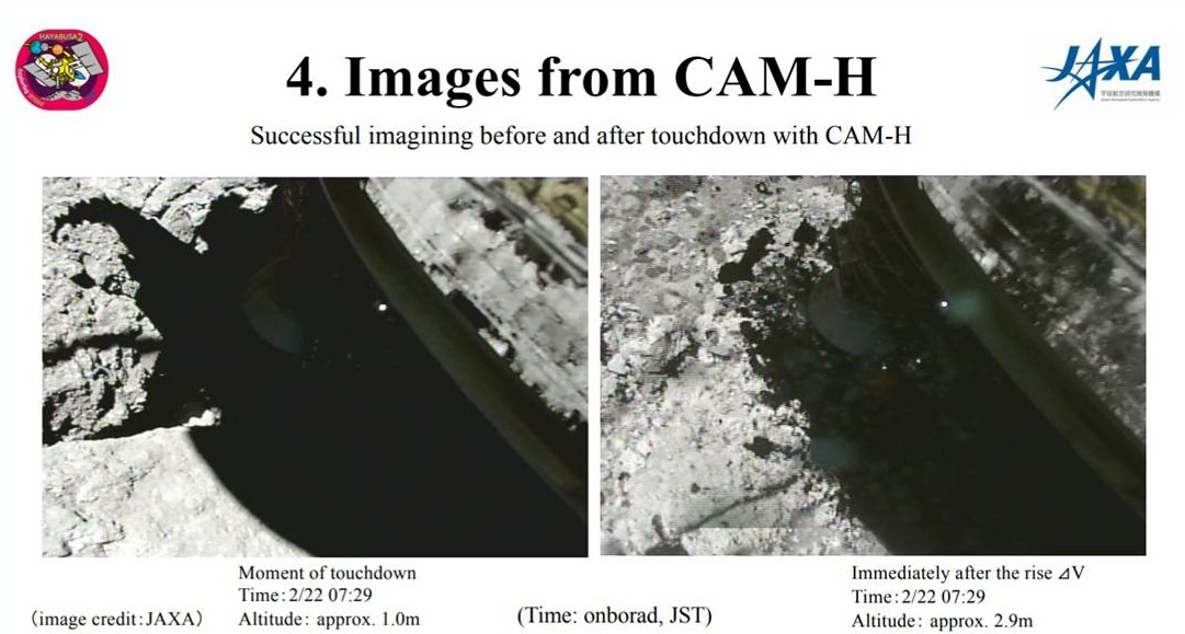
Noted within the press briefing, scientific analysis is in progress, but the following describes initial impressions from imagery taken by Hayabusa2.
- There seems to be an area containing a lot of debris/particle scattering / floating material just above Ryugu’s surface.
- There also seems to be abrasions on the ground made with the sampling bullet and thruster firing.
- A large quantity of scattered particles/debris can be seen: the potential for sample collection is high.
- Fine particles may have adhered to the lens of the ONC-W1 camera.
- The sampler horn seemed able to make contact with the ground without striking any large rocks.
- Surface images are similar to those captured by the Hayabusa2-deployed landers: the surface is covered with rocks of average size about 10 centimeters.
- After touchdown, rocks reaching sizes of several tens of centimeters in diameter were ejected.
- Many chips of this released debris are flattened plate-shaped and appear to reach quite a high altitude.
Credit: JAXA
Credit: JAXA
Credit: Michaela Musilova
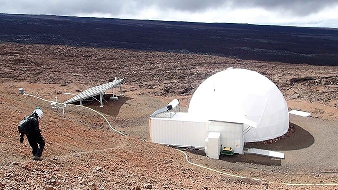
An international crew of six engaged in a Moon/Mars simulation is set to end their work on Wednesday, March 6th – a two-week mission to perform scientific experiments and test technological instruments needed for the future exploration of the Moon or Mars.
Credit: Michaela Musilova
The effort began on February 20 at the University of Hawaiʻi at Mānoa’s Hawaiʻi Space Exploration Analog and Simulation (HI-SEAS) habitat on the slopes of Mauna Loa on Hawaiʻi Island.
The mission is under the EuroMoonMars initiative, led by the International Lunar Exploration Working Group (ILEWG) of the European Space Agency (ESA).

Credit: Michaela Musilova
This simulation has been done in collaboration with the International Moonbase Alliance (IMA), European Space Research and Technology Centre, Vrije Universiteit (VU) Amsterdam and HI-SEAS.
Prototype moonbase
It is part of a series of projects led by IMA, which is planning on building a moonbase on the Moon and a prototype moonbase on Hawaiʻi Island.
Credit: Michaela Musilova
“These missions can be of much shorter duration than the previous missions that took place at HI-SEAS,” said University of Hawaiʻi at Mānoa’s Michaela Musilova, chief investigator for HI-SEAS and the International Moonbase Alliance. “These missions are open to researchers around the world to take part in, provided their research will help contribute to the exploration and colonization of the Moon and Mars,” Musilova said in a university press statement.
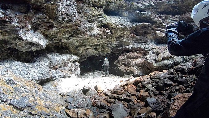
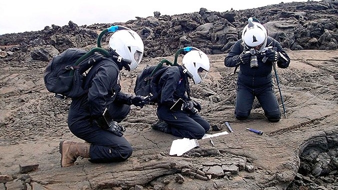
Musilova said that the crew’s research included geological and drone surveys, lava tube exploration and space technology testing.
They have also been cooking with shelf stable ingredients and passing some of their free time playing cards.
Mission control
The mission control center for these missions is based at the Blue Planet Research laboratory on the Big Island, which is owned by the IMA founder Henk Rogers.
Bernard Foing of the European Space Agency and executive director of ILEWG has been serving as the space-crew communicator at the mission control center.
Musilova, who is also serving as crew commander, previously stated that the mission was off to a “very good start,” in spite of some challenges with power cycling on and off and a temporary “disconnection from Earth.”

Shoot for the Moon – The Space Race and the Extraordinary Voyage of Apollo 11 by James Donovan; Little, Brown and Company (2019); 454 pages, $30.00.
This impressive book is a must-read this year given that it’s the 50th anniversary of the Apollo 11 mission – humankind’s first high-stepping trek to Earth’s Moon.
As a space aged old-timer I found author Donovan’s account a memory-jarring read, chock full of details that my fellow page-turners will truly enjoy.
The book is divided into 4 parts that add up to 17 chapters of brilliant reading. Be it “Cossacks in Space,” “Of Monkeys and Men,” to “You’re go, and “Descent to Luna,” Donovan doesn’t skimp on the triumph that was Apollo, how American spunk and spirit made it happen, and how the achievement was sparked by the U.S.-Soviet Union space race.
The connective tissue to Apollo – the single-seat Mercury and Gemini two-seater missions – is expertly detailed and is a solid contribution to the overall book. As the author also points out in the book’s early pages: “Rockets exploded. Systems malfunctioned. Men died. The murder of a visionary president whose bold challenge had fired the program only reaffirmed their dedication to finishing the job.”
Shoot for the Moon carries a number of fresh interviews with space controllers and engineers, as well as Apollo astronauts, further adding to this engaging and very well-researched volume. The book includes three segments of black and white/color images that provide a visual ramp-up to the Apollo 11 adventure.
Donovan is author of the bestselling books A Terrible Glory- Custer and the Little Bighorn, The Last Great Battle of the American West and The Blood of Heroes: The 13-Day Struggle for the Alamo – and the Sacrifice that Forged a Nation.
Being a Wild West historian, I’m thankful Donovan wrote this book of pioneering the space frontier.
For more information on this book, on sale March 12th, go to:
https://www.littlebrown.com/titles/james-donovan/shoot-for-the-moon/9780316341783/
Also, go to this informative video at:

Artist view of China’s space station. Credit: CMSE
The China Manned Space Agency has stated the country will start launching preparatory tests for its manned space station mission in the second half of this year.
According to a report in China Daily, the agency said in a statement on Monday that the core module of the space station, a Long March 5B carrier rocket and payloads to be carried by the rocket’s maiden flight will be transported to the Wenchang Space Launch Site in the island province of Hainan in the second half of 2019 to conduct joint tests and drills.

Long March-5 booster’s first liftoff occurred in early November 2016. Mishap on launcher’s second flight in July 2017. A return-to-flight Long March-5 mission is slated for this year.
Credit: CASC
After those tests and drills, the Long March 5B rocket will carry out its debut flight at the Wenchang site at a proper time, the agency said. However, no time for the launch has been detailed.
Currently, the space station’s core module and a Long March 5B are under construction, the agency said, adding that it is also selecting and training astronauts for this mission.
Under construction
According to government plans previously made public, China will start putting together its first manned space station around 2020 and in the first step, a Long March 5B will put the station’s core module into orbit that year. Next, other components and astronauts will be ferried to the core module to assemble the station.
The space station is expected to be built and become fully operational around 2022 and is set to operate for about 15 years, according to the China Academy of Space Technology, contractor of the station’s development and construction.

