Author Archive

The candy-pink Laguna de Peña Hueca derives its colour from the red cells of the salt-loving algae Dunaliella salina EP-1.
Credit: Europlanet/F Gómez/R Thombre
A candy-pink lagoon here on Earth has implications for the search for life on Mars.
A microorganism has been discovered that provides new evidence for how life could survive on a “high-salt” diet on Mars and perhaps beneath Europa’s icy façade.
Dunaliella salina EP-1 is one of the most salt-tolerant extremophiles that has been found. The microorganism has implications for how algae might be used to terraform Mars.
Findings from a study of microorganisms found in Laguna de Peña Hueca, part of the Lake Tirez system in La Mancha, Spain, is being presented this week at the European Planetary Science Congress 2018 in Berlin.

Credit: Europlanet/F Gómez/R Thombre
Lagoon water
Presenting their research: Rebecca Thombre of the Department of Biotechnology, at the Modern College of Arts, Science and Commerce in Shivajinagar, Pune, India, and Felipe Gómez of the Centro de Astrobiología, Madrid, Spain.
The research team collected samples of lagoon water and studied the physical characteristics and genetic sequence of the isolated microorganisms. They found that the lagoon’s pink color derives from the red cells of a sub-genus of the salt-loving algae Dunaliella.
The lagoon has very high concentrations of salt and sulphur and is a good analogue for chloride deposits found in the southern highlands of Mars and briny water beneath Europa’s icy crust.

This extremophilic algal strain from Laguna de Peña Hueca has been named Dunaliella salina EP-1 after the Europlanet 2020 Research Infrastructure.
Credit: Europlanet/F Gomez/R Thombre
Industrial applications
The cells of Dunaliella algae are used in many countries for the industrial production of carotenoids, ß-carotene, glycerol, bioactives, biofuel and antioxidants, so the strain EP-1 may have applications for a range of biotechnologies.
“Considering the commercial and economic significance of this organism, future studies are warranted to gain a complete picture of its physiology, ecology and biotechnological potential,” Thombre said in a press statement.
The resilience of extremophiles to the conditions of Mars analogues on Earth demonstrate their potential to thrive in martian soils, Gómez added. “This has implications for planetary protection, as well as how algae might be used to terraform Mars.”
The abstract for the meeting — Extremophiles from Tirez and Peña Hueca: Implications for exploring habitability of Mars and Europa — is here:
https://meetingorganizer.copernicus.org/EPSC2018/EPSC2018-1180.pdf

NASA Curiosity rover on the Red Planet prowl since August 2012 and assessing the habitability of Mars.
Credit: NASA/JPL-Caltech/MSSS
Issues have cropped up with NASA’s Curiosity Mars rover – something akin to robotic Alzheimer’s disease.
“Over the past few days, engineers here at JPL have been working to address an issue on Curiosity that is preventing it from sending much of the science and engineering data stored in its memory,” reports Ashwin Vasavada, the Mars Science Laboratory project scientist at NASA/JPL in Pasadena, California.
Meanwhile, the rover remains in its normal mode and is otherwise healthy and responsive. Vasavada adds.
Diagnose the problem
The issue first appeared Saturday night while Curiosity was running through the weekend plan.
Besides transmitting data recorded in its memory, the rover can transmit “real-time” data when it links to a relay orbiter or Deep Space Network antenna. These real-time data are transmitting normally, and include various details about the rover’s status, Vasavada adds. “Engineers are expanding the details the rover transmits in these real-time data to better diagnose the issue. Because the amount of data coming down is limited, it might take some time for the engineering team to diagnose the problem.”

Curiosity Front Hazcam Left B image taken back on Sol 2172, September 15, 2018.
Credit: NASA/JPL-Caltech
Backup computer
Vasavada adds that on Monday and Tuesday, engineers discussed which real-time details would be the most useful to have. “They also commanded the rover to turn off science instruments that were still on, since their data are not being stored. They’re also preparing to use the rover’s backup computer in case they need to use it to diagnose the primary computer. That backup computer was the rover’s primary one until Sol 200, when it experienced both a hardware failure and software issue that have since been addressed.”
Another drill attempt
While engineers work to understand the problem, Vasavada points out that Curiosity’s science team is using the time to pore over data gathered on Vera Rubin Ridge “and come up with the best location for another drilling attempt.”
“We’re looking at any clues that tell us the rocks are weaker and better for drilling. As the JPL-based project scientist, I really enjoy watching our scientists from all over the world take on these challenges,” Vasavada says. “And, I also get to witness the brainpower that JPL brings to bear when the rover has a technical issue. We’re rooting for the engineering team 100%!”
Meanwhile, just a touch of the dire: “This blog may be less frequent until science operations resume,” Vasavada concludes.
No new imagery has come in from Curiosity since Sol 2172. The rover is now in Sol 2176.
Meanwhile, not a peep from the only other active rover on Mars, NASA’s Opportunity robot.

China Mars lander
Credit: CCTV America
China is shaping a deep space exploration plan, including launch of two Mars missions, one in 2020 and a return sample mission in 2028.
According to the China News Service, the country will launch its first Mars probe in 2020. After ten months of flight, the probe will orbit, land and deposit a rover on the Red Planet in 2021.

NASA Mars 2020 rover is designed to collect samples, store the specimens in tubes, then deposit the tubes on the surface for later pick-up.
Credit: NASA/ESA
If successful, that mission will join NASA’s Mars 2020 rover, as well as the European Space Agency’s ExoMars 2020 rover.
China’s second Mars probe is scheduled for 2028 to bring samples back to Earth.
In addition, China’s deep space to do list includes asteroid exploration and undertaking a mission to the Jupiter system around 2030.
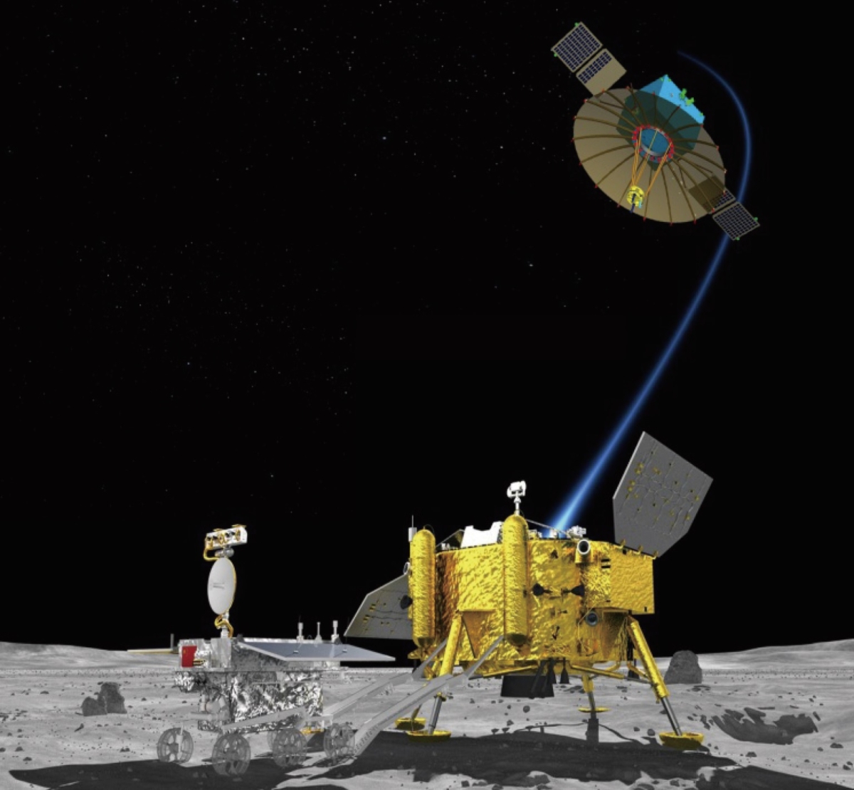
Chang’e-4 Moon lander and rover.
Credit: Chinese Academy of Sciences
In December of this year, China’s Chang’e-4 lunar probe is to launch, headed for a landing in Aitken Basin of the lunar south pole region on the far side of the Moon.

Astrobotic is developing navigation technologies to allow free-flying spacecraft to explore subterranean environments on the Moon, such as lava tubes.
Credit: Astrobotic Technology/RIS4E/SSERVI/Stony Brook University

Skylights on the Moon are collapses that occur over subsurface voids. Skylights occur in many terrestrial lava tubes, providing access, although sometimes requiring shimming down a rope. Shown here is a skylight in the Moon’s Marius Hills.
Credit: NASA/GSFC/Arizona State University
By tapping robotic and sensor technologies, a small free-flying spacecraft is being demonstrated to autonomously investigate lava tubes on the Moon.
Astrobotic Technology of Pittsburgh, Pennsylvania is partnering with scientists from the RIS4E node of NASA’s Solar System Exploration Research Virtual Institute (SSERVI), led by Stony Brook University.
High-priority targets
Lunar lava tubes are high-priority targets for scientific research because they provide access to geologic formations that have been shielded from space weathering for billions of years.
These features may contain a preserved record of the conditions present during the formation of the lunar mare.
While these tubes are rich in scientific samples, an Astrobotic statement explains that they could also be ideal locations for future human settlements because they provide natural protection from radiation and micrometeoroids.

The city of Philadelphia is shown inside a theoretical lunar lava tube. A Purdue University team of researchers explored whether lava tubes more than one kilometer wide could remain structurally stable on the Moon.
Credit: Purdue University/courtesy of David Blair
Lunar skylights
“While lava tubes are difficult to access because they are buried below the lunar surface, roof collapses, known as skylights, offer a tantalizing way to access the subsurface,” the Astrobotic statements adds. “Long hypothesized to exist, only in the past decade have numerous lunar skylights been detected from orbital imagery, and scientists have recently discovered that the Moon may host massive networks of lava tubes.”

Astrobotic field-tested their autonomous navigation in Aden Crater in the Potrillo Lava Fields, New Mexico. The geologic features in the field are an analog environment for the Moon or Mars. The team deployed with the SSERVI RIS4E team in March 2018. Credit: Astrobotic Technology/RIS4E/SSERVI/Stony Brook University
Sensing modalities
Under a research contract with NASA, Astrobotic has developed a custom navigation software product, known as AstroNav.
To explore sub-surface environments on the Moon, Astrobotic’s AstroNav employs both stereo vision- and LiDAR-based navigation, works without GPS or previously stored maps (neither of which exist in the target environment), and can operate in real-time.
Combining sensing modalities allows a spacecraft to perform a seamless traverse over the lunar surface before dropping into a skylight from above.

The Potrillo Lava Fields in New Mexico contain features that are thought to be analogous to the lava flows Moon and Mars, including skylights that could offer access to subsurface lava tubes.
Credit: Astrobotic Technology/RIS4E/SSERVI/Stony Brook University
Field testing
This past April, Astrobotic’s Future Missions and Technology team joined the RIS4E SSERVI team at a field test site in New Mexico to demonstrate a number of key technologies required for these Moon missions.
The field site — known as the Potrillo Volcanic Field — has volcanic features analogous to those found on the Moon and Mars, and the collaboration between the teams sought to address the challenges of conducting extra-planetary geologic data and sample collection from autonomous aerial science platforms.

RIS4E team members deploy a portable hyperspectral infrared camera to investigate the mineralogy of volcanic rocks at Kilbourne Hole in the Potrillo Lava Fields.
Credit: Astrobotic Technology/RIS4E/SSERVI/Stony Brook University
Astrobotic’s research was funded in part by NASA’s Small Business Technology Transfer (STTR) program. Under this contract, Astrobotic will perform a field demonstration of AstroNav technology in lava tubes in the coming months.
Go to this video showing RIS4E team members deploying a portable hyperspectral infrared camera to investigate the mineralogy of volcanic rocks at Kilbourne Hole in the Potrillo Lava Fields, available at:
https://www.youtube.com/watch?v=wZfidjKQrko&feature=youtu.be

Curiosity’s Mars Hand Lens Imager (MAHLI) photo produced on Sol 2172, September 15, 2018. MAHLI is located on the turret at the end of the rover’s robotic arm.
Credit: NASA/JPL-Caltech/MSSS
NASA’s Curiosity Mars rover is now carrying out Sol 2175 duties.
Curiosity’s latest drill attempt was not successful, reports Vivian Sun, a planetary geologist at NASA/JPL in Pasadena, California. “Who’d have thought that ridge rocks could be so hard.”
Drilling into the target rock, “Inverness,” the rover equipment reached only 4 millimeters into the rock.

Curiosity ChemCam Remote Micro-Imager photo acquired on Sol 2172, September 15, 2018.
Credit: NASA/JPL-Caltech/LANL
Next drive
Scientists have been discussing where to drive the robot next.
“The grey Jura member is a top priority for sampling and understanding the geologic history of the Vera Rubin Ridge, so we felt it was imperative to try again,” Sun adds. “We ultimately decided to return to the “Lake Orcadie” region, where we previously attempted to drill on Sol 1977.”

Curiosity Mastcam Right image acquired on Sol 2172, September 15, 2018.
Credit: NASA/JPL-Caltech/MSSS
In the past attempt, Curiosity was able to reach 10 millimeters depth using rotary only, “so we are hopeful that this next attempt will reach sampling depths with the new percussion-enhanced drill capabilities,” Sun explains.
Before driving off, Curiosity wrapped up at the Inverness site with Alpha Particle X-Ray Spectrometer (APXS) and Chemistry and Camera (ChemCam) spectral measurements to characterize the composition of the drill tailings and the mini drill hole.
Possible meteorite targets
“We additionally targeted ‘Clune,’ a gray Jura bedrock, with ChemCam to continue our documentation of compositional heterogeneities in bedrock. Some science team members also identified two possible meteorite targets, so we obtained a ChemCam measurement of ‘Stoneyburn’ and a Mastcam multispectral observation of ‘Rockend’ to see if they have meteorite compositions,” Sun explains.

Curiosity Mastcam Left photo taken on Sol 2172, September 15, 2018.
Credit: NASA/JPL-Caltech/MSSS
New drill site
On Sol 2173, the plan called for a long drive of over 210 feet (65 meters) to get Curiosity close to the new drill site in the Lake Orcadie region.
A Sol 2174 plan also included ChemCam calibration and sky observations, as well as taking Mars Descent Imager (MARDI) twilight imagery to document the terrain beneath the rover.
“If all goes well,” Sun concludes, “we should be at our next drill site in no time!”

Credit: Mattel, Inc. Dream Chaser toy.
Sierra Nevada Corporation’s (SNC) Dream Chaser spacecraft has shrunk – but to just the right size to become a toy in the Matchbox Sky Busters® line. That line showcases America’s best and most groundbreaking aircraft and spacecraft, including NASA’s space shuttle.
To be sold in stores starting this month, the full-scale Dream Chaser spacecraft is a reusable and versatile vehicle for low-Earth orbit that is scheduled to service the International Space Station starting in late 2020 for NASA cargo missions under the Commercial Services Resupply 2 (CRS-2) contract 2.
All Dream Chaser CRS2 cargo missions are planned to land at Kennedy Space Center’s Shuttle Landing Facility.
The vehicle’s unique winged design and runway landing make it the only spacecraft of its kind in the commercial space industry.

Credit: SpaceX
SpaceX has signed the world’s first private passenger to fly around the Moon aboard their Big Falcon Rocket launch vehicle – an important step toward enabling access for everyday people who dream of traveling to space, according to the SpaceX website.

Credit: SpaceX
Only 24 humans have been to the Moon in history. Twelve humans walked across the lunar landscape, and no one has traveled to the vicinity of the Moon since the last Apollo mission in 1972.

Credit: SpaceX
Find out who’s flying, why, and hopefully when, on Monday, September 17 at 6pm Pacific Time.
Go to:

Credit: Astrobotic Technology, Inc.
It’s a good day for privately-backed lunar landers.
NASA’s Science Mission Directorate (SMD) has released a Request for Information (RFI) so the space agency can assess proposals for Lunar Surface Instrument and Technology Payloads.
This NASA program element would solicit flight payloads that do not require significant additional development.
Science goals, knowledge gaps, tech demos
Investigations are being sought that address the science goals of any of four SMD space agency divisions: Planetary, Earth Science, Heliophysics, and Astrophysics.
Also being eyed are flight payloads for tackling Strategic Knowledge Gaps of the Human Exploration and Operations Mission Directorate (HEOMD) or any technology demonstration goals of the Space Technology Mission Directorate (STMD) that advance capabilities for science, exploration, or commercial development of the Moon.

Private sector Moon rover.
Credit: Carnegie Mellon/Mark Maxwell
Flight opportunity
The first lander flight opportunity could occur as early as 2020. As such, proposals should “convincingly demonstrate” that the proposed payload will be ready to support an aggressive launch schedule.
The deadline for this RFI is September 27, 2018.
“This is yet another important development for our community,” said Dan Hendrickson, Vice President of Business Development at Astrobotic Technology, Inc. in Pittsburgh, Pennsylvania. They are among several groups striving to give the Moon the business. “NASA highly encourages payload teams to reach out to commercial lander service providers directly,” Hendrickson added in an Astrobotic statement.
For detailed information, go to:

Curiosity Front Hazcam Left B image acquired on Sol 2168, September 11, 2018.
Credit: NASA/JPL-Caltech
NASA’s Curiosity Mars rover is performing Sol 2169 tasks.
The robot’s drill campaign at “Inverness” is starting, reports Kristen Bennett, a planetary geologist at the USGS in Flagstaff, Arizona.
“In the weekend plan Curiosity drove to an area that the team thought would be a good location for the next drill site on Vera Rubin Ridge. The drive was a success, and there is a block named ‘Inverness’ in the center of the workspace that was selected to be the next drill target,” Bennett explains.

Curiosity Navcam Left B photo taken on Sol 2168, September 11, 2018.
Credit: NASA/JPL-Caltech
Two-sol plan
The two-sol plan (Sol 2168-2169) focuses on characterizing Inverness in preparation for the drill campaign. This includes removing dust from the surface of the rock with the Dust Removal Tool, as well as taking Mars Hand Lens Imager (MAHLI) images, Alpha Particle X-Ray Spectrometer (APXS) measurements, a Chemistry and Camera (ChemCam) Laser Induced Breakdown Spectroscopy (LIBS) observation, and a Mastcam multispectral observation of Inverness.
“In addition to all of the measurements of Inverness, Curiosity will begin taking change detection images,” Bennett adds. “The rover will be sitting in one spot for some time during the drill campaign, so this is a good opportunity to see if any of the sand around Curiosity is being moved around by the wind.”

Dust Removal Tool readies targeted rock for drilling. Curiosity Mars Hand Lens Imager (MAHLI) image produced on Sol 2168, September 11, 2018. MAHLI is located on the turret at the end of the rover’s robotic arm.
Credit: NASA/JPL-Caltech/MSSS
The current plan also includes a Mars Descent Imager (MARDI) twilight image and Mastcam images of “Sandend” and “Skene.”
Putting holes in rocks
“But wait! There’s more! This plan also includes a Mastcam image of the target “Stoneyburn,” a Navcam dust devil survey,” Bennett adds, along with MAHLI night time images of the Chemistry & Mineralogy X-Ray Diffraction/X-Ray Fluorescence Instrument (CheMin) inlet.

Chemistry & Mineralogy X-Ray Diffraction/X-Ray Fluorescence Instrument (CheMin) inlet.
Curiosity Mars Hand Lens Imager (MAHLI) photo taken on Sol 2168, September 12, 2018.
Credit: NASA/JPL-Caltech/MSSS
“This full 2-sol plan will set Curiosity up to start drilling into the next target on Vera Rubin Ridge later this week,” Bennett concludes. “Just another day planning to put holes in rocks on Mars!”

Credit: Baker Institute for Public Policy
Making high-quality satellite imagery available to the broader global energy research community can help crack open China’s “Great Wall of Secrecy” and improve data transparency and insights into the inner workings of the world’s second-largest crude oil market.
A new study — Using Satellite Data to Crack the Great Wall of Secrecy Around China’s Internal Oil Flows – has been issued by Rice University’s James A. Baker III Institute for Public Policy.
Data gathering sensors
Even if data gatherers on the ground in China can be constrained by the risk of severe physical penalties, Chinese officials can do little to prevent remote sensors in space from gathering data on energy sector activities.
They suggest that better data transparency would benefit oil producers and consumers both within and outside of China.

Satellite imagery of oil activity in China.
Credit: Baker Institute for Public Policy/DigitalGlobe, Google Earth
Time-lapse imagery
“Satellites passing repeatedly over the same area can provide a time-lapse image series that can help identify the construction of roads and pipelines, well completions, drilling rig movement, and other important energy-related activities,” the authors explain.
The new study was written by Gabriel Collins, J.D., Baker Botts Fellow in Energy & Environmental Regulatory Affairs, Center for Energy Studies and Shih Yu (Elsie) Hung, Research Associate, Center for Energy Studies.
To view a copy of the document — Using Satellite Data to Crack the Great Wall of Secrecy Around China’s Internal Oil Flows — go to:
https://www.bakerinstitute.org/media/files/files/5b820dd5/bi-report-090718-ces-satellitechinaoil.pdf

