Archive for September, 2022

Credit: Mars Guy
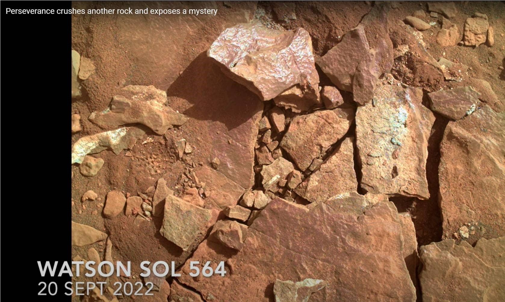
The NASA Perseverance rover crushed another rock on Mars and exposed a mystery.
Explains Mars Guy (Steve Ruff of Arizona State University), after returning to a location dubbed Enchanted Lake, NASA’s Perseverance Mars rover attempted an abrasion operation on a rock too weak to handle it. The rock shattered into pieces, revealing a paint-like purple coating that defies easy explanation.
Credit: Mars Guy
Go to this Mars Guy video for details at: https://youtu.be/00P7ZgrBfLc

Image acquired on Sept. 24, 2022 (Sol 567 of the Perseverance rover mission) using its navigation camera mounted in the helicopter’s fuselage and pointed directly downward to track the ground during flight.
Image Credit: NASA/JPL-Caltech
NASA Ingenuity Mars Helicopter looks to have carried out flight number 33.
According to JPL, the craft was targeted to head West; reach a maximum altitude of 33 feet (10 meters); the expected distance was to be roughly 365 feet (111.238 meters) flying at 10.6 mph (4.75 m/s); and an expected time aloft was slated for 55.61 seconds.
The goal of flight 33 was to reposition the helicopter.

Curiosity’s location as of Sol 3601. Distance driven on that sol: 17.83 miles/28.69 kilometers.
Credit: NASA/JPL-Caltech/Univ. of Arizona
NASA’s Curiosity Mars rover at Gale Crater is now performing Sol 3602 duties.
Some fresh new imagery spotlights the surrounding terrain:

Curiosity Right B Navigation Camera photo acquired on Sol 3600, September 22, 2022.
Credit: NASA/JPL-Caltech

Curiosity Mast Camera Right image taken on Sol 3600, September 22, 2022.
Credit: NASA/JPL-Caltech/MSSS

Curiosity Front Hazard Avoidance Camera Right B image taken on Sol 3601 September 23, 2022.
Credit: NASA/JPL-Caltech

Curiosity Left B Navigation Camera image taken on Sol 3601, September 23, 2022.
Credit: NASA/JPL-Caltech

Curiosity Left B Navigation Camera image taken on Sol 3601, September 23, 2022.
Credit: NASA/JPL-Caltech

Air Force Band members and guests sing the new U.S. Space Force service song during the 2022 Air, Space and Cyber Conference in National Harbor, Md., Sept. 20, 2022. (U.S. Air Force photo by Eric Dietrich)
The U.S. Space Force, the newest military branch established in 2019, has officially adopted its own song titled “Semper Supra.” It was unveiled during the 2022 Air & Space Forces Association Air, Space and Cyber Conference in National Harbor, Maryland, Sept. 20.
To listen to the song, go to:
https://www.dvidshub.net/video/857934/us-space-force-reveals-official-song

Map view with base dataset, clickable viewpoints are marked as droplets. (Image: HiRISE/CTX/HRSC)/Europlanet Society
Prospective Mars explorers can now take a walk around the landing site of NASA’s Perseverance rover.
An interactive map that can be accessed through a normal web browser is loaded with orbital imagery, terrain data as well as synthetic and real 3D panoramic views of Jezero crater and its surrounding area.
“The map is the perfect tool for planning a future visit to Mars, with an interactive interface where you can choose from different available base datasets,” explains Sebastian Walter of the Freie Universität Berlin. “Some of the slopes are pretty steep, so watch out for those if you want to avoid too much oxygen consumption!”

Virtual view from top of the western delta into the crater. Credit: HiRISE/CTX/HRSC/Europlanet Society
“To get a real feeling of what to expect on your future Mars trip, you can click on one of the waypoint marker symbols to enter either a full-screen 3D view or, if you have a Virtual Reality setup, to enter a fully immersive environment. You can even listen to the sounds of the rover if you stand close by, but please don’t touch it – otherwise you would contaminate the probes.”
The base layer of the map is a merged dataset derived from three different instruments currently orbiting Mars, carried by Europe’s Mars Express, and NASA’s Mars Reconnaissance Orbiter.
Go to this direct link to the interactive map (wait for map to fully unfold):
https://maps.planet.fu-berlin.de/jezero
Also, for more details, go to this Europlanet Society news release – “Virtual hiking Map for Jezero Crater, the Mars 2020 Perseverance Rover Landing Site” – at:
https://www.europlanet-society.org/virtual-hiking-map-for-jezero-crater/

Russia’s Igor Mitrofanov
Credit: ESA–Stephane Corvaja
Russia’s lunar exploration program faces delay, according to Igor Mitrofanov, head of the Department of Nuclear Planetology of the Space Research Institute (IKI) of the Russian Academy of Sciences.
The first robotic Moon mission, Luna-25 had been previously postponed to 2023. Now the launches of Luna-26, Luna-27 and Luna-28 may be postponed for up to two years, Mitrofanov told Russia’s TASS news agency.

Luna-25
Credit: NPO Lavochkin
The Luna-26 mission was to be launched in 2024, Luna-27 in 2025, Luna-28 in 2027-2028.
Supply chain issue
“Our main problem today, which has a fundamental impact, is import substitution. Because of this, the dates will be postponed, maybe each mission will be postponed for a year, maybe even for two,” Mitrofanov said.
According to Mitrofanov, supply chain issues of certain components have forced the delay of a string of Luna probes.

Luna-26
Credit: NPO Lavochkin
The suite of Moon probes are part of the Luna-Glob program by Roscosmos.
The Luna-25 spacecraft is a small-sized demonstration landing station for testing basic soft landing technologies in the circumpolar region and conducting contact studies of the south pole of the Moon.

Luna-27
Credit: NPO Lavochkin
Luna-26 is a lunar orbiter designed to carry out remote sensing of the lunar surface.
Luna-27 is intended to be a lander for testing the technology of high-precision and safe touchdown landing in the Moon’s south pole region, including drilling to a depth of 2 meters using a cryogenic deep drilling rig.

Luna-28
Credit: NPO Lavochkin
Luna-28 is designed for delivery back to Earth of lunar soil from the region of the south pole of the Moon.

European Space Agency astronaut Samantha Cristoforetti gives the Vulcan salute aboard the International Space Station.
(Image credit: NASA/ESA)
Space life scientists are pushing for the development of an international database on long-term health effects of spaceflight. They feel it is essential for protecting the health and performance of current and future crew members of all nationalities, as well as defining the long-term health consequences for retired crew members across the globe.
That said there are thorny legal and privacy challenges ahead.

NASA astronaut Christina Koch pauses as she helps replace equipment on the International Space Station. She and her fellow astronauts faced a suite of health effects while in space. (Image credit: NASA)
(opens in new tab)
Given that there are now roughly 120 international retired space crew members still alive, collecting medical/health data on these crew members has the potential to expand the total “n” for health outcomes in space explorers by 40 percent.
Understanding the long-term human health impact of space exploration missions is exceptionally challenging.
Why so?
For more information, go to my new Space.com story – “Can we live long and prosper in space? The astronaut health dilemma – Relatively few humans have ever been exposed to the space environment” – at:
https://www.space.com/live-long-prosper-long-term-spaceflight-health-risks

Credit: CMSA/CCTV/Inside Outer Space screengrab
On September 17, during the second extravehicular activity of the Shenzhou-14 mission, astronauts verified an extravehicular rescue capability, the first spacewalk rescue exercise during the construction period of China’s space station.
With the aid of the small mechanical arm, two astronauts conducted a series of extravehicular tasks, including the installation of extravehicular assistance handles.
The astronauts also installed additional pumps, the core equipment of the space station’s thermal control system, and carry out the challenging task of extravehicular rescue for the first time, according to China Central Television (CCTV).

Credit: CCTV/Inside Outer Space screengrab
Assist handle
Chen Dong and Cai Xuzhe performed the tasks, with Liu Yang providing support inside the cabin. The Shenzhou-14 twosome completed their tasks during a roughly five hour period.
The taikonauts opened the airlock cabin of the Wentian lab module making their exit into space. The extravehicular activities included installing foot-stop b, which will facilitate work on the bulkhead, and an assist handle that can help astronauts open the hatch door from outside in emergency.
For videos detailing the rescue exercise, go to:

Credit: Astrobotic
LunaGrid is the first-ever commercial power service for the lunar surface. It will enable space agencies, companies, and nonprofit systems to survive the lunar night and operate indefinitely on the Moon.
Pittsburgh, Pennsylvania-based Astrobotic is offering LunaGrid, a power generation and distribution service that will deliver power by the watt to landers, rovers, habitats, science suites, and other lunar surface systems.
The company plans to begin deploying and demonstrating LunaGrid elements as early as 2026 with the goal of the first operational LunaGrid by 2028 at the lunar south pole.

Illustration of NASA astronauts on the lunar south pole carrying out early work to establish an Artemis Base Camp. Credit: NASA
According to a company statement, the service will enable space agencies’, companies’, and nonprofits’ systems to survive the lunar night and operate indefinitely on the Moon starting at the lunar south pole.
No policy hurdles
LunaGrid makes use of the company’s landers, rovers, and wireless chargers as well its Vertical Solar Array Technology (VSAT), which is in development at Astrobotic in concert with NASA’s Space Technology Mission Directorate. Astrobotic was awarded in August a follow-on $6.2 million contract by to further advance its VSAT systems.

LunaGrid makes use of Astrobotic’s existing landers, rovers, and wireless chargers as well its Vertical Solar Array Technology (VSAT).
Credit: Astrobotic
LunaGrid systems can be delivered on a single Griffin lander and placed at multiple locations at the poles of the Moon. LunaGrid can also be scaled over time, the company states, increasing the service coverage with additional VSATs, and incorporating other power source types in the future.
“Solar power is affordable, commercially friendly, technically mature, and deployable now. LunaGrid’s solar-based system offers the world the fastest, most economical means of establishing sustained lunar presence with no policy hurdles,” said Astrobotic CEO, John Thornton.

InSight’s first full selfie on Mars.
Credit: NASA/JPL-Caltech
In a Jet Propulsion Laboratory release, NASA’s InSight lander on Mars detected seismic waves from a meteoroid and was able to capture the sound of the space rock striking the surface of Mars for the first time.
The meteoroid – the term used for incoming space rocks before they hit the ground – entered Mars’ atmosphere on Sept. 5, 2021, exploding into at least three shards that each left craters behind.
Mars’ atmosphere is just 1% as dense as Earth’s, allowing far more meteoroids to pass through and impact the Red Planet’s surface.

InSight’s Instrument Deployment Camera (IDC) acquired this image showing the HP3 experiment and SEIS seismometer (Seismic Experiment for Interior Structures) on Sol 99, March 8, 2019.
Credit: NASA/JPL-Caltech
Bloop!
This event marks the first time seismic and acoustic waves from an impact were detected on the Red Planet. Why does this meteoroid impact sound like a “bloop” in the video? It has to do with a peculiar atmospheric effect that’s also observed in deserts on Earth.
After sunset, the atmosphere retains some heat accumulated during the day. Sound waves travel through this heated atmosphere at different speeds, depending on their frequency. As a result, lower-pitched sounds arrive before high-pitched sounds. An observer close to the impact would hear a “bang,” while someone many miles away would hear the bass sounds first, creating a “bloop.”

Location confirmation
NASA’s Mars Reconnaissance Orbiter flew over the estimated impact site to confirm the location. The orbiter used its black-and-white Context Camera to reveal three darkened spots on the surface.
After locating these spots, the orbiter’s team used the High-Resolution Imaging Science Experiment camera, or HiRISE, to get a color close-up of the craters.

InSight Detects an Impact for the First Time: These craters were formed by a Sept. 5, 2021, meteoroid impact on Mars, the first to be detected by NASA’s InSight. Taken by NASA’s Mars Reconnaissance Orbiter, this enhanced-color image highlights the dust and soil disturbed by the impact in blue in order to make details more visible to the human eye. Credits: NASA/JPL-Caltech/University of Arizona.
Because HiRISE sees wavelengths the human eye can’t detect, scientists change the camera’s filters to enhance the color of the image. The areas that appear blue around the craters are where dust has been removed or disturbed by the blast of the impact. Martian dust is bright and red, so removing it makes the surface appear relatively dark and blue.
Credit for the research goes to NASA/JPL-Caltech/University of Maryland/University of Arizona/CNES/IPGP/Manchu/Bureau 21/ETH Zurich/Kirschner/van Driel.
Give an ear and eye to this video at:

