Archive for September, 2021

Blood Falls seeps from the end of the Taylor Glacier into Lake Bonney. The tent at left provides a sense of scale for just how big the phenomenon is. Scientists believe a buried saltwater reservoir is partly responsible for the discoloration, which is a form of reduced iron.
Photograph by Peter Rejcek/United States Antarctic Program
Taylor Glacier in Antarctica’s McMurdo Dry Valleys features Blood Falls.
Researchers first thought the red color came from algae. Later work unveiled that the glacier is a natural time capsule, containing an ancient community of microbes.
The existence of the Blood Falls ecosystem shows that life can exist in the highly extreme conditions here on Earth – but perhaps elsewhere in the form of extraterrestrial life.

Moon of Jupiter, Europa, is about 90 percent the size of Earth’s Moon. Perhaps Europa is a promising place in our solar system to find present-day environments suitable for some form of life beyond Earth.
Go to this intriguing story in Atlas Obscrua: “Blood Falls Antarctica -Natural time capsule containing an alien ecosystem” at:
https://www.atlasobscura.com/places/blood-falls
Also, go to this paper “MICROBIAL LIFE IN BLOOD FALLS: AN ANCIENT ANTARCTIC ECOSYSTEM” at:
https://www.lpi.usra.edu/meetings/earlymars2004/pdf/8023.pdf
As well as this Arizona State University press release “Unlikely life thriving at Antarctica’s Blood Falls” at:
https://news.asu.edu/content/unlikely-life-thriving-antarctica%E2%80%99s-blood-falls

Credit: ISS/NASA
A lunar resources ecosystem having a $32 billion economic impact after 20 years is plausible – but there are critical uncertainties and several variables.
New research delves into a rosy “Moonopolis” scenario and a low-resources, “Apollo 2.0” future.
Appearing in the journal, Acta Astronautica, the research paper is titled: “The cis-lunar ecosystem – A systems model and scenarios of the resource industry and its impact,” authored by Marc-Andre Chavy-Macdonald, Kazuya Oizumi, Jean-Paul Kneib, and Kazuhiro Aoyama.

Credit: Marc-Andre Chavy-Macdonald, et al.
Complex trade-off
“Lunar resources is one of the many new putative business models that may transform space logistics. Yet it competes with Earth-based resources, in a complex trade-off involving both tech development & socioeconomic dynamics,” the paper states.
The study models the size versus time of a future resource ecosystem focused on water for exploration and satellite refueling – in cis-lunar space.
Top critical uncertainties include the accessibility of resource finds on the Moon, and government investment in lunar resources. Three variables are crucial, the research team notes: government support to production development, production firms’ re-investment, and growth of the Geosynchronous Earth Orbiting (GEO) telecom satellite industry.

Credit: Marc-Andre Chavy-Macdonald, et al.
Well-placed near Earth
The Moon and cis-lunar space, the paper explains, is a far more accessible target than Mars colonization, and has drawn the attention of diverse public and private players in a nearer time horizon: space agencies, large firms, start-ups etc.
“Indeed the Moon is well-placed near Earth, and its much shorter transit time is crucial for human operations. It has a relatively favorable geography for resources: a large, diverse geological body at an energetically advantageous location for space transport.”
In summary, the research has combined societal and technical variables and captured knowledge from dozens of experts to create a holistic model of a future, complex ecosystem around lunar resources.
This work was supported by the Ministry of Education, Culture, Sports, Science and Technology (MEXT) of Japan (GSDM program), and by the Swiss Space Office (Research Initiative on Sustainable Space Logistics).
To access “The cis-lunar ecosystem – A systems model and scenarios of the resource industry and its impact” go to:
https://www.sciencedirect.com/science/article/pii/S0094576521003143?via%3Dihub
NASA’s Curiosity Mars rover at Gale Crater is now performing Sol 3231 tasks
Newly relayed imagery shows the robot’s #33 hole, drilling at “Maria Gordon” on sol 3229.

Curiosity Mast Camera Left image taken on Sol 3229, September 5, 2021.
Credit: NASA/JPL-Caltech/MSSS

Curiosity Mast Camera Right photo acquired on Sol 3229, September 5, 2021.
Credit: NASA/JPL-Caltech/MSSS

Curiosity Front Hazard Avoidance Camera Left B image taken on Sol 3229, September 5, 2021.
Credit: NASA/JPL-Caltech

Curiosity Front Hazard Avoidance Camera Left B image taken on Sol 3229, September 5, 2021.
Credit: NASA/JPL-Caltech

Curiosity Left B Navigation Camera image taken on Sol 3229, September 5, 2021.
Credit: NASA/JPL-Caltech

Credit: Taiwan Innovative Space (tiSPACE)
In the next few days, Australia is set to enter the global space services market.
The Hapith I rocket is to depart the Whalers Way Orbital Launch Complex, located on the tip of the Eyre Peninsula in South Australia
The Launch Complex covers approximately 1200 Ha (2965 acres) of open land with over 6 km (3.72 miles) of ocean frontage.

Credit: Southern Launch
Space company — Southern Launch — is carrying out the maiden flight of a two-stage suborbital rocket using Taiwan Innovative Space (tiSPACE) hybrid propulsion technology. The launch window is September 9–23.
Southern Launch is providing the infrastructure and logistics support for orbital and suborbital launches from the organization’s two sites in South Australia: Whalers Way Orbital Launch Complex and the Koonibba Test Range.

Credit: Southern Launch
Commercially attractive
On March 25 the Australian government announced the first ever license for a space launch facility, legally permitting rockets to fly into space from Australian territory.

Credit: Southern Launch
The license was granted to wholly Australian-owned company Southern Launch for its Koonibba Test Range in the South Australian outback. The Koonibba Test Range is located 25 miles (40 kilometers) north-west of Ceduna on the West Coast of the Eyre Peninsula, South Australia
The significance of the Koonibba Test Range is that Australia can now host private satellite operators and rocket manufacturers from around the world to come and test their space technologies in a safe and commercially attractive manner from Australia.
For more information, go to:
https://www.southernlaunch.space/
Video at: https://youtu.be/y26ZIdxVI3E

Credit: ESA/SOM
It is described as the most desirable real estate in the Solar System: the rim of Shackleton crater at the lunar south pole.
Toss in for good measure a semi-inflatable habitat design which could be part of a long-term vision for an international Moon settlement.

Credit: ESA/SOM
Avoiding the crippling temperature extremes of the Moon’s two-week days and nights, Shackleton crater’s rim offers near-continuous sunlight for solar power, an ongoing view of Earth and potential access to suspected lunar water ice deposits in adjacent permanently-shadowed craters.
European Space Agency experts have teamed with leading architects at Skidmore, Owings and Merrill (SOM) on a Moon Village project. The results of the work are being exhibited at the 17th International Architecture Exhibition of La Biennale di Venezia in Venice, Italy.
Shell structure
Moon Village is a hypothetical concept for lunar settlement through an alliance of private and public, space and non-space partners.

Model of settlement at Shackleton crater rim.
Credit: Laurian Ghinitoiu
SOM architects designed a four story, semi-inflatable shell structure to offer the highest possible volume to mass ratio. Once inflated on the lunar surface, it would reach approximately double its original internal volume.
After landing, the habitat would be inflated either locally by astronauts or via rovers teleoperated from the Gateway station around the Moon. It would keep its four person crew alive and comfortable for up to 300 days at the time.

Credit: ESA/SOM
Modular configurations
The Moon Village relies on modular configurations of habitable structures, integrated with numerous systems including docking capability, environmental control, and life support systems (ECLSS), health equipment, radiation shielding, and other critical features.
A single unit offers a net habitable volume of up to 390 cubic meters (13,773 cubic feet) and a net usable area of up to 104 cubic meters (1,120 cubic feet) distributed between multiple levels.
The primary structure is projected to the perimeter, maximizing the functions of centralized spaces and increasing free volume. Modules are designed to be interconnected, enabling seamless mobility throughout the settlement.
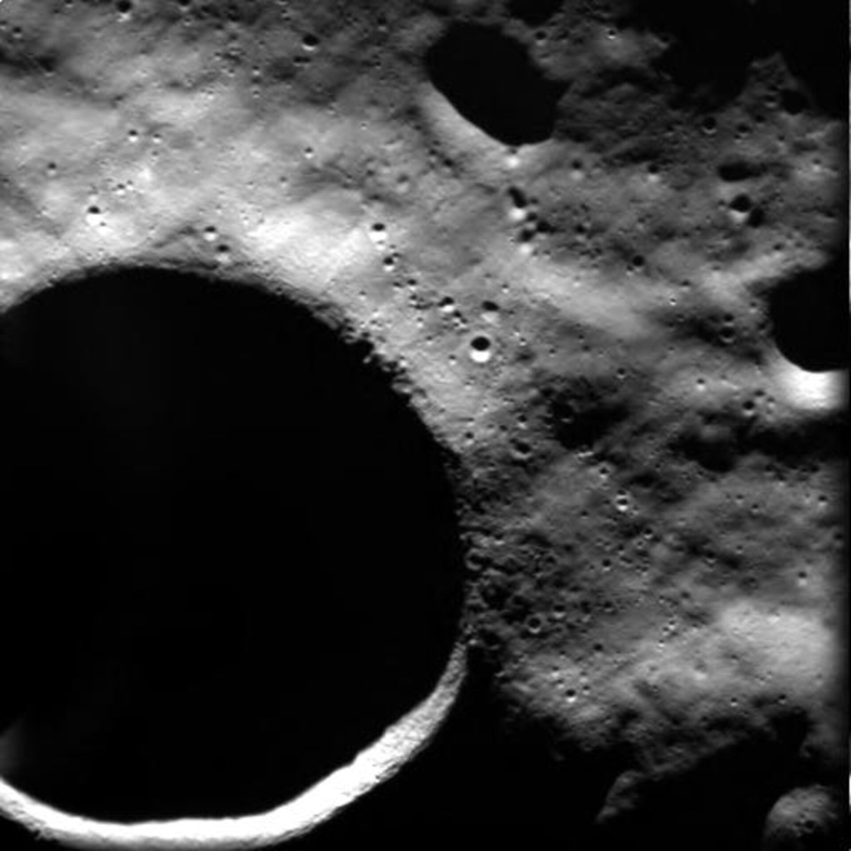
This image, taken by the advanced Moon Imaging Experiment (AMIE) on board ESA’s SMART-1 spacecraft, shows crater Shackleton on the Moon.
Credit: ESA
Master plan
The master plan envisions a Moon Village sited on the rim of Shackleton Crater in the south polar region, on the “peaks of eternal light” which receive near-continuous daylight throughout the lunar year.
This strategic location supports the goal of a self-sufficient settlement. Sunlight can be harnessed for energy, while on-the-spot resources can be used to generate consumables and other life-sustaining elements.
Suspected frozen volatiles and water stored in the permanently shadowed craters near the South Pole would be extracted to create breathable air and rocket propellant for transportation and industrial activities. The settlement would be clustered and expanded along strategic sites, rich in resources and scientific interest.
Shackleton crater lies at the lunar South Pole, at 89.54° South latitude and 0° East longitude, and has a diameter of 12 miles (19 kilometers).
Go to these SOM videos at:

Curiosity Mast Camera Left photo taken on Sol 3225, September 1, 2021.
Credit: NASA/JPL-Caltech/MSSS
NASA’s Curiosity Mars rover at Gale Crater is now performing Sol 3228 duties.
Susanne Schwenzer, a planetary geologist at The Open University, Milton Keynes, in the U.K., reports that the robot is surveying a spectacular landscape. “The higher we climb the more spectacular and rugged the scenery appears.”
Four-sol plan
A recent two-sol plan for sols 3226-3227 was not uplinked, so the rover had a two-sol break.

Curiosity Mast Camera Left photo taken on Sol 3225, September 1, 2021.
Credit: NASA/JPL-Caltech/MSSS
“The next plan is a four-sol plan because of Monday being the Labor Day holiday in the US. As a consequence, the plan now has drill preparations,” Schwenzer adds, such as doing a Chemistry and Camera (ChemCam) raster, the Dust Removal Tool and Mastcam multispectral observation of the drill site on sol 3228, and getting Chemistry & Mineralogy X-Ray Diffraction/X-Ray Fluorescence Instrument (CheMin) ready, too.

Curiosity Mast Camera Left photo taken on Sol 3225, September 1, 2021.
Credit: NASA/JPL-Caltech/MSSS
Drill plan
“Curiosity will drill at “Maria Gordon” on sol 3229, followed by portion characterization, and Mastcam multispectral investigation and ChemCam passive spectral investigation of the drill tailings,” Schwenzer points out. “So, when we come back from our holiday here on Earth, we shall see images of drill hole #33 on Mars. Second time lucky!”

Curiosity Mast Camera Left photo taken on Sol 3225, September 1, 2021.
Credit: NASA/JPL-Caltech/MSSS
With a four-sol plan to come, there is a lot more to do for Curiosity.

Curiosity Mast Camera Left photo taken on Sol 3225, September 1, 2021.
Credit: NASA/JPL-Caltech/MSSS
Frost investigation
“We are back in the season where frost events are likely. Therefore, a frost detection investigation on the target ‘Mangersta Sands’ is in the plan, whereby the target will be investigated twice, once very early in the morning and once during daytime for a comparison of the hydrogen, a proxy for water content at different times,” Schwenzer reports.
Curiosity’s Mastcam is taking two large mosaics to document the spectacular landscape – “because spectacular to look at is not just an aesthetic judgment, there is a lot of geology to see, too, with different layers, textures and structures,” Schwenzer says.
Last but not least, the rover will also make the standard atmospheric observations, Dynamic Albedo of Neutrons (DAN) and Rover Environmental Monitoring Station (REMS) investigations.

Among the sites now surrounding Curiosity is a steep, shadowed cliff visible in the upper left corner of this image taken by Left Navigation Camera on Sol 3222.
Credit: NASA/JPL-Caltech
NASA’s Curiosity Mars rover at Gale Crater is now performing Sol 3225 tasks.
Michelle Minitti, a planetary geologist at Framework in Silver Spring, Maryland, reports the robot’s short drive over last weekend took it within half a meter of a desired parking elevation – a prelude for the next attempt at drilling in Gale Crater.
Steep shadowed cliff
Among the sites surrounding Curiosity is a steep, shadowed cliff.

Curiosity Front Hazard Avoidance Camera Left B photo taken on Sol 3224, August 31, 2021.
Credit: NASA/JPL-Caltech
“That cliff marks the western wall of our narrow passageway up Mount Sharp,” Minitti notes, “which the team has named “Maria Gordon Notch.””

Maria Ogilvie Gordon, Scottish scientist
Credit: Wachtler – http://historyofgeology.fieldofscience.com/2011/06/women-geoscientist-in-dolomites-maria.html, Public Domain
Maria Ogilvie Gordon was a Scottish scientist in the late 19th and early 20th centuries with expertise in geology, paleontology, and zoology, Minitti adds.
“She combined her knowledge of modern and fossil corals and extensive fieldwork campaigns to describe the geologic history and stratigraphy of the Dolomite Mountains of Italy. Her work earned her the first Doctor of Science awarded to a woman in the United Kingdom. While Curiosity might not find corals on her way up Mount Sharp, she will certainly strive to follow Maria Gordon’s example of careful, thorough and important geologic work!”
As the rover sits within view of Maria Gordon Notch, the science team thought it only natural to name its next drill site after her, too.

Brushing off target. Curiosity Mars Hand Lens Imager (MAHLI) photo produced on Sol 3224, August 31, 2021.
Credit: NASA/JPL-Caltech/MSSS
Load testing
Thus, a recently scripted plan focused on brushing the candidate drill target, “Maria Gordon,” followed by Mars Hand Lens Imager (MAHLI) imaging, Alpha Particle X-Ray Spectrometer (APXS) analyses, and load testing of the target.
Also run was a Chemistry & Mineralogy X-Ray Diffraction/X-Ray Fluorescence Instrument (CheMin) empty cell analysis to make sure that vessel is ready to receive sample, Minitti explains. “Those activities and the next anticipated activity – drilling itself – require a lot of power, so there was not much time for additional science observations.”

Curiosity Right B Navigation Camera photo acquired on Sol 3224, August 31, 2021.
Credit: NASA/JPL-Caltech
Rover Environmental Monitoring Station (REMS), Dynamic Albedo of Neutrons (DAN), and Radiation Assessment Detector (RAD) are slated to run at their regular cadence across the two sols of the plan, Minitti adds, “but the only additional environmentally-focused observation we added was a Navcam dust devil survey.”

Curiosity Right B Navigation Camera image taken on Sol 3223, August 30, 2021.
Credit: NASA/JPL-Caltech
Mastcam mosaic
The geology working group managed to squeeze in a survey of their own, a 360 degree Mastcam mosaic acquired early in the morning.

Curiosity Right B Navigation Camera image taken on Sol 3223, August 30, 2021.
Credit: NASA/JPL-Caltech
“The early morning time was desired to get lighting on the east-facing cliffs – including Maria Gordon Notch – rising from the terrain around us,” Minitti concludes. “The mosaic will surely provide a great overview of this site, and will help guide our subsequent observations among our own mountains of exploration.”

