Archive for June, 2018
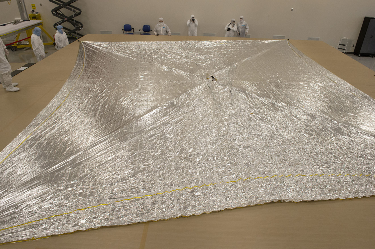
Solar sail test to be utilized by the Near-Earth Asteroid Scout (NEA Scout).
Credit: NASA/Emmett Given
A solar sail to be used in NASA’s Near-Earth Asteroid Scout has been deployed in a ground test facility.
The test was performed in an indoor clean room at the NeXolve facility in Huntsville, Alabama.
The Near-Earth Asteroid Scout (NEA Scout) is a small satellite designed to study asteroids close to Earth. The successful deployment test took place on June 28.
Six-unit cubesat
NEA Scout is a six-unit CubeSat that relies on a solar sail for propulsion. It is one of 13 secondary science payloads NASA selected to fly on NASA’s Exploration Mission-1 (EM-1).
EM-1 will be the first integrated test of NASA’s Space Launch System rocket, NASA’s Orion spacecraft and the newly upgraded Exploration Ground Systems at Kennedy Space Center in Florida.

Deep space destination
In addition to testing these integrated systems, EM-1 will also provide the opportunity for these small experiments to reach deep space destinations, conducting science missions and testing key technologies beyond low-Earth orbit.
NEA Scout will deploy from the rocket after the Orion spacecraft is separated from the upper stage. When deployed, the sail, which is square in shape, with each side about the length of a school bus, will harness the light of the sun to use as propulsion to move through space.
Curiosity Navcam Right B image acquired on Sol 2095, June 28, 2018.
Credit: NASA/JPL-Caltech
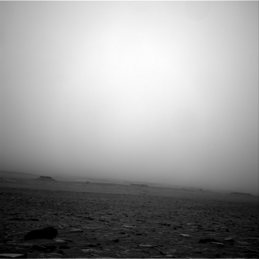
Now performing Sol 2096 duties, NASA’s Mars Curiosity rover has made a steep drive on Sol 2094 and is back over the crest of Vera Rubin Ridge and enjoying the view of flatter terrain ahead.
That’s the report from Lauren Edgar, a planetary geologist at the USGS in Flagstaff, Arizona.
“Everything was going smoothly and we were excited to plan some potential contact science, until we found a rock under the left front wheel that might make Curiosity unstable during arm activities,” Edgar explains.
Weekend plan
At the last minute Mars scientists swapped out Mars Hand Lens Imager (MAHLI)
MAHLI and Alpha Particle X-Ray Spectrometer (APXS) activities for some additional remote sensing.
“We still packed a lot of science into the two-sol plan, and we’ll have another opportunity to do contact science in the weekend plan,” Edgar explains.
The first sol plan included a Chemistry and Camera (ChemCam) and Mastcam observations of “Crosby” and “Hekkla Lake” to characterize the bedrock at this location.
“This plan is also full of atmospheric observations to monitor the ongoing dust storm, which will provide some great data from the surface regarding this unique event,” Edgar adds.
Curiosity Mastcam Left image acquired on Sol 2094, June 27, 2018.
Credit: NASA/JPL-Caltech/MSSS
Rover deck
“We also planned Mastcam imaging of the rover deck to monitor the accumulation and movement of fine material,” Edgar continues, “as well as a number of ChemCam calibration activities under high atmospheric opacity conditions.”
The plan calls for the robot to continue driving to the south and it will acquire post-drive imaging to prepare for the weekend plan.
Curiosity Navcam Right B image acquired on Sol 2095, June 28, 2018.
Credit: NASA/JPL-Caltech
Hoping for clear skies
Overnight, the rover’s Chemistry & Mineralogy X-Ray Diffraction/X-Ray Fluorescence Instrument (CheMin) was slated to carry out the last analysis of the Duluth drill sample.
A second sol plain outlined more atmospheric monitoring and calibration activities, along with a ChemCam Autonomous Exploration for Gathering Increased Science (AEGIS) observation to autonomously target bedrock in the rover’s new location.
“Hoping for clearer skies,” Edgar concludes, “and fewer loose rocks under our wheels!”
New map!

Credit: NASA/JPL-Caltech/Univ. of Arizona
Meanwhile, a new Curiosity Rover location map for Sol 2094 has been issued.
The map shows the route driven by NASA’s Mars rover Curiosity through the 2094 Martian day, or sol, of the rover’s mission on Mars (June 28, 2018).
Numbering of the dots along the line indicate the sol number of each drive. North is up. From Sol 2092 to Sol 2094, Curiosity had driven a straight line distance of about 114.27 feet (34.83 meters).
Since touching down in Bradbury Landing in August 2012, Curiosity has driven 11.91 miles (19.17 kilometers).
The base image from the map is from the High Resolution Imaging Science Experiment Camera (HiRISE) in NASA’s Mars Reconnaissance Orbiter.

Artist’s view of the James Webb Space Telescope (JWST) in space, up and operating tackling a full agenda of space science conquests.
Credit: Northrop Grumman
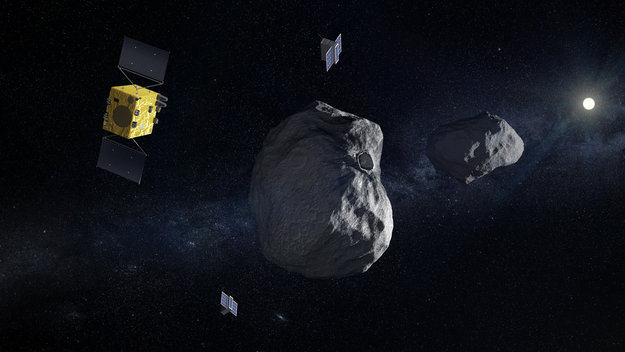
Hera mission is part of an international cooperation aimed at testing whether the orbit of an asteroid can be shifted by smashing into it.
Credit: ESA
The European Space Agency is working with NASA on a double-spacecraft mission – a test of how to deflect an asteroid.
Called Hera, named for the Greek goddess of marriage, this candidate mission is up for consideration during the Agency’s Council of Ministers at European Level in late 2019.
Dart
In 2022, NASA’s Double Asteroid Redirection Test (DART) spacecraft will first perform a kinetic impact on the smaller of the two bodies of the Didymos binary near-Earth asteroids. Then Hera will follow-up with a detailed post-impact survey that will turn this grand-scale experiment into a well-understood and repeatable planetary defense technique.
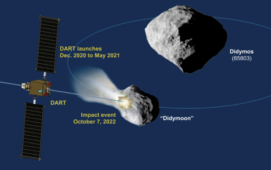
These objects will come a comparatively close 7 million miles (11 million kilometers) to Earth in 2022.
Didymoon
The 800-meter diameter Didymos is orbited by a 170-meter “moonlet” informally called “Didymoon.” That smaller object is more typical of the size of asteroids that could pose a more common hazard to Earth.
Hera will also gather crucial scientific data on asteroids as a whole by carefully studying the exterior and interior properties of both bodies in the system.
The ESA-provided spacecraft will also host two 6-unit cubesats that will be deployed near Didymos to perform, for the first time ever, multi-point measurements in a “mother-daughter” configuration.
Close-proximity operations
A novel intersatellite link will be used to establish a flexible communications network supporting the close-proximity operations in very low-gravity conditions, a crucial step for future exploration activities around small bodies.
For a video of this asteroid deflection mission, go to:
http://www.esa.int/spaceinvideos/Videos/2018/06/Hera_mission2
Asteroid Day is a UN-sanctioned global awareness campaign. This year thousands of self-organized events will be hosted around the world. Join our Asteroid Day LIVE broadcast, 48 hours of content and commentary from around the world.
Stellar lineup
Hosted by Professor Brian Cox, he will be joined by astronauts, experts and celebrities. Asteroid Day is a global program supporting thousands of independently organized events on June 30th, provides online educational asteroid resources 365 days a year and produces a 24-hour global broadcast with an all-star lineup called Asteroid Day LIVE from Luxembourg.

Asteroid Day is held on June 30 each year to mark the date of Earth’s largest asteroid impact in recorded history, the Siberia Tunguska event, which devastated over 2,000 km2 of forest in 1908
Check out these websites at:
https://asteroidday.org/#guests
Also, go to this informative video at:
In case all you bright-eyed sky watchers missed it, a verdict on the James Webb Space Telescope via an external independent review board now finds the JWST a tad behind: Now March 2021.
Rejoice in this overview by the NASA chief, Bridentstine:
Background resources
To read a recent Government Accountability Office (GAO) review of JWST, go to this Highlights Page at:
https://www.gao.gov/assets/700/690412.pdf
No doubt, Webb will be the world’s premier infrared space observatory and the largest astronomical space science telescope ever built.
But it has been a long saunter down the infrared carpet for the telescope.
Integration delays
NASA has previously announced that JWST’s launch would be delayed several months, from October 2018 to no later than June 2019, because components of the telescope are taking longer to integrate than planned.
Take a look at my Scientific American story for details about the JWST:
Is the James Webb Space Telescope “Too Big to Fail?” – Backers of NASA’s next great observatory contemplate its worst-case scenarios
https://www.scientificamerican.com/article/is-the-james-webb-space-telescope-too-big-to-fail/
For a video look at JWST, go to the Northrop Grumman overview published on Jan 24, 2017 at:
Credit: Black Swift Technologies
Black Swift Technologies, a Boulder, Colorado-based firm, has been awarded a NASA contract to develop an aerial vehicle for atmospheric observations of Venus.
“Black Swift Technologies has provided aerial solutions for wild land fires, volcanic observations, tornadoes, and hurricanes—some of the most extreme phenomena on Earth,” explains Jack Elston, CEO of the company. “This mission is a natural extension of our focus, only now we are concentrating on the extreme conditions of Venus.”
Dynamic soaring
As a specialized engineering firm, Black Swift Technologies (BST) provides purpose-built scientific aerial platforms. BST is proposing a planetary aerial vehicle based on dynamic soaring, a proven method to extract energy from atmospheric shear that has propelled the fastest small-scale aircraft in the world, and provided the energy necessary for long-endurance low-level flights of birds across oceans.

A composite image of the planet Venus as seen by the Japanese probe Akatsuki. The clouds of Venus could have environmental conditions conducive to microbial life.
Credit: JAXA
“Our solution will be designed to not only survive in the harsh wind environment, but also simultaneously perform targeted sampling of the atmosphere while continuously extracting energy, even on the dark side of the planet,” Elston points out in a press statement.
Upper atmosphere
Despite the fact that the surface temperature of Venus is hotter than any other planet in the Solar System at 467°C, the atmospheric pressure and temperature at about 30 miles (50 kilometers) to 40 miles (65 kilometers) above the surface of the planet is nearly the same as that of the Earth.
That makes the planet’s upper atmosphere the most Earth-like area in the solar system, even more so than the surface of Mars.

Don Mitchell, a retired researcher, matched his computer science skills with a passion for old spacecraft data to reveal never-before-seen details in Soviet Union Venera-13 lander images.
Credit: Don Mitchell
Super rotation
The atmosphere of Venus is composed primarily of carbon dioxide and nitrogen and is much denser and hotter than that of Earth. The upper layer of Venus’ atmosphere exhibits a phenomenon of super-rotation, where the atmosphere circles the planet in just four Earth days.
The resulting winds blow at speeds up to 100 m/s (360 km/h or 220 mph). On the other hand, the wind speed becomes increasingly slower as the elevation from the surface decreases, with the breeze barely reaching the speed of 2.8 m/s (10 km/h) on the surface.
Founded in 2011, Black Swift Technologies offers unmanned aircraft systems (UAS) capable of flying scientific payloads in demanding atmospheric environments (high-altitude, corrosive particulates, and strong turbulence).

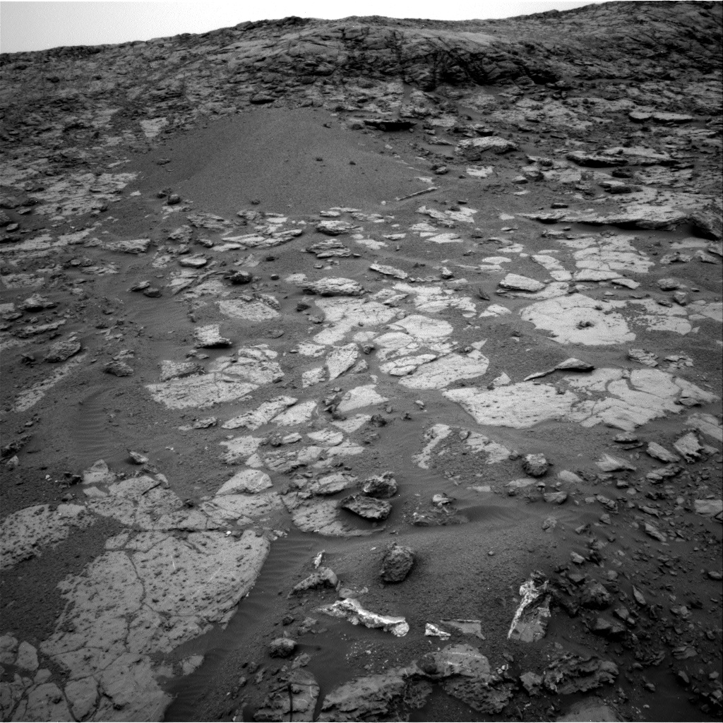
Curiosity Front Hazcam Left B image acquired on Sol 2093, June 26, 2018.
Credit: NASA/JPL-Caltech
NASA’s Curiosity Mars rover is now performing Sol 2094 duties.
Reports Lauren Edgar, a planetary geologist for the USGS in Flagstaff, Arizona: a recent two-sol plan kicked off with the good news that the rover’s power state exceeded predictions, so Mars researchers were able to add in some extra science activities.
Dust storm
The first sol called for several remote sensing activities to continue monitoring the ongoing dust storm.

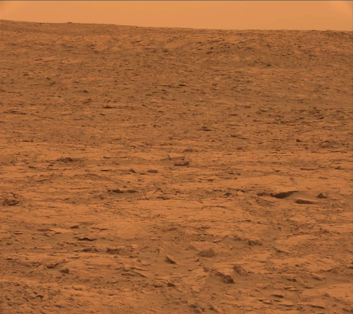
Curiosity Mastcam Left photo taken on Sol 2092, June 25, 2018.
Credit: NASA/JPL-Caltech/MSSS
Then the team planned several Chemistry and Camera (ChemCam) observations of “Mudhole Lake,” “Jacobs Lake,” and “Monker Lake” to assess the bedrock chemistry and search for evaporites, Edgar explains, followed by Mastcam documentation.
In the afternoon, Curiosity was slated to acquire a short multispectral tau observation to measure the optical depth of the atmosphere and constrain aerosol scattering properties.

Curiosity Mastcam Left photo taken on Sol 2092, June 25, 2018.
Credit: NASA/JPL-Caltech/MSSS
Driving south
Given the extra power, but without many appealing contact science targets, the team decided to get an Alpha Particle X-Ray Spectrometer (APXS) calibration target observation overnight.
On the second sol Curiosity was to continue driving up the steep slope to the south, followed by post-drive imaging and further atmospheric observations, Edgar concludes.

Curiosity Mastcam Left photo acquired on Sol 2092, June 25, 2018.
Credit: NASA/JPL-Caltech/MSSS

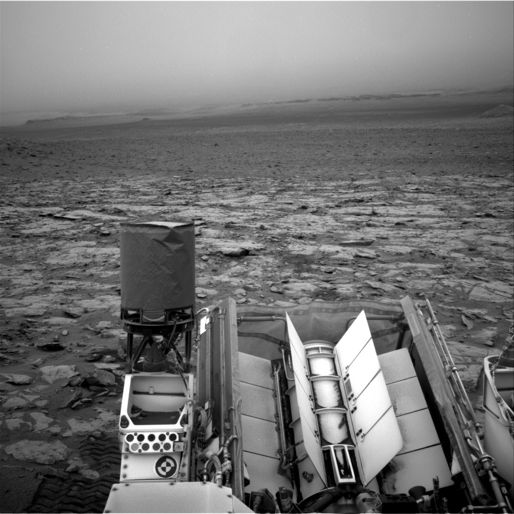
Curiosity Front Hazcam Right B image taken on Sol 2092, June 25, 2018.
Credit: NASA/JPL-Caltech
NASA’s Curiosity Mars rover is now performing Sol 2093 duties.
Notes Ryan Anderson, a planetary geologist for the USGS in Flagstaff, Arizona: “Despite the global dust storm — more correctly known as a ‘planet encircling dust event’ — darkening the skies, our nuclear-powered rover continues to do good science.”
Curiosity Navcam Right B photo acquired on Sol 2091, June 24, 2018.
Credit: NASA/JPL-Caltech
Veins and layers
A Sol 2090 plan called for the first of several Navcam observations of the dusty atmosphere over last weekend, followed by Chemistry and Camera (ChemCam) observations of the targets “Caribou Lake,” “Simar,” and “Arlberg”. ChemCam also will image the target “Young Lake” again.

Curiosity Navcam Left B image taken on Sol 2092, June 25, 2018.
Credit: NASA/JPL-Caltech
The rover’s Mastcam will take individual pictures of the ChemCam targets on Arlberg and Caribou Lake, plus small stereo mosaics of Simar and “Hawk Ridge” to help measure the orientation of the veins and layers seen there, Anderson reports.
MAHLI dust check
Mastcam will then make some observations of the Sun and the distant crater rim to measure the dust in the atmosphere and the robot’s Mars Descent Imager (MARDI) was set to take an image of the ground underneath the rover.
Later in the afternoon on Sol 2090, Anderson adds, Mastcam was slated to take images of the rover’s Mars Hand Lens Imager (MAHLI) to make sure it isn’t getting too dusty. APXS will then make two measurements: one on “Hunter Lake” and another on Caribou Lake.

Curiosity Navcam Left B image acquired on Sol 2092, June 25, 2018.
Credit: NASA/JPL-Caltech
Rover drive
On Sol 2091, the plan was to start first thing in the morning with Mastcam and Navcam atmospheric measurements of dust and searches for clouds. Later in the morning, Curiosity was to repeat some of the dust observations and Mastcam was on tap to take pictures of “Clappers,” Hunter Lake, and Caribou Lake.
On Sol 2092, the plan called for use of the Sample Analysis at Mars (SAM) Instrument Suite to make a measurement of the atmospheric composition, and then Navcam was to measure the dust in the atmosphere before a rover drive.
Anderson explains that the drive should go about 92 feet (28 meters), heading back up the slope toward the top of Vera Rubin Ridge.

Checking on Mars Hand Lens Imager (MAHLI) and dust. Curiosity Mastcam Right photo acquired on Sol 2090, June 23, 2018.
Credit: NASA/JPL-Caltech/MSSS
After the drive, Mastcam is scheduled to take another round of atmospheric dust measurements plus normal post-drive imaging, including a documentation image of the ground near the rover.
MARDI was also to take a documentation image, Anderson concludes.

Curiosity Navcam Left B image acquired on Sol 2092, June 25, 2018.
Credit: NASA/JPL-Caltech

Asteroid Ryugu from a distance of about 40 kilometers. Details of the asteroid surface are now clear, giving food for thought about the best locations for surface operations. Credit: JAXA, University of Tokyo & collaborators.
Japan’s Haybusa2 is imaging asteroid Ryugu – and revealing a host of engineering challenges ahead for spacecraft operations.
“The shape of Ryugu is now revealed,” explains Hayabusa2 Project Manager, Yuichi Tsuda for the Japan Aerospace Exploration Agency (JAXA).

Japan’s Hayabusa2 is pulling up to Ryugu – a C-type asteroid – for detailed study.
Artwork: Akihiro Ikeshita
“From a distance, Ryugu initially appeared round, then gradually turned into a square before becoming a beautiful shape similar to fluorite [known as the ‘firefly stone’ in Japanese]. Now, craters are visible, rocks are visible and the geographical features are seen to vary from place to place. This form of Ryugu is scientifically surprising and also poses a few engineering challenges,” Tsuda adds.
Rotation axis
According to Tsuda, first of all, the rotation axis of the asteroid is perpendicular to the orbit. This fact increases the degrees of freedom for landing and the rover decent operations.
On the other hand, there is a peak in the vicinity of the equator and a number of large craters, which makes the selection of the landing points both interesting and difficult, Tsuda points out.
Formulate plans
“Globally, the asteroid also has a shape like fluorite (or maybe an abacus bead?). This means we expect the direction of the gravitational force on the wide areas of the asteroid surface to not point directly down. We therefore need a detailed investigation of these properties to formulate our future operation plans,” Tsuda explains in a Hayabusa2 posting.
“The Project Team is fascinated by the appearance of Ryugu and morale is rising at the prospect of this challenge,” Tsuda notes. “Together with all of you, we have become the first eyewitnesses to see asteroid Ryugu. I feel this amazing honor as we proceed with the mission operations.”

