Archive for September, 2017

Discovery of SMART-1 impact site thanks to an eagle-eyed researcher and high resolution Lunar Reconnaissance Orbiter images.
Credit: P Stooke/B Foing et al 2017/ NASA/GSFC/Arizona State University
In the lost and now found category of Moon probes add the European Space Agency’s first lunar mission, SMART-1 to the list.
Thanks to the sharp-eyed Phil Stooke, of Western University, Ontario, using high-resolution images from NASA’s Lunar Reconnaissance Orbiter (LRO), the spacecraft’s impact site has been discovered.
The spacecraft was sent into a controlled impact with the lunar surface 11 years ago.

European Space Agency’s SMART-1 lunar orbiter.
Credit: ESA
Hard, grazing, bouncing landing
Explains Bernard Foing, ESA SMART-1 Project Scientist: “SMART-1 had a hard, grazing and bouncing landing at two kilometers per second on the surface of the Moon. There were no other spacecraft in orbit at the time to give a close-up view of the impact, and finding the precise location became a ‘cold case’ for more than 10 years.”
The next steps will be to send a robotic investigator, Foing adds, “to examine the remains of the SMART-1 spacecraft body and ‘wings’ of the solar arrays.”

Another view of SMART-1 crash site, as spotted within high resolution Lunar Reconnaissance Orbiter images.
Credit: P Stooke/B Foing et al 2017/ NASA/GSFC/Arizona State University
Ricochet rocketry
Images from LRO show white ejecta, over 20 feet (seven meters) across, from the first contact.
A north-south channel has then been carved out by the SMART-1 spacecraft body, before its bouncing ricochet.
“We can make out three faint but distinct ejecta streams from the impact, about 40 meters long and separated by 20-degree angles,” Foing reports in a paper delivered this week at the European Planetary Science Congress (EPSC) 2017 in Riga.
The crash scene of SMART-1 is 34.262° south and 46.193° west, consistent with the coordinates of impact calculated initially, according to a EPSC press statement.

So long, goodbye trajectory of ESA’s SMART-1 spacecraft that ended with impact on the lunar surface.
Credit: ESA – C.Carreau, CC BY-SA 3.0 IGO
Tested new technology
SMART stands for Small Missions for Advanced Research in Technology.
SMART-1 is the first of ESA’s Small Missions for Advanced Research in Technology. It traveled to the Moon using solar-electric propulsion and carrying a battery of miniaturized instruments.
As well as testing new technology, SMART-1 did the first comprehensive inventory of key chemical elements in the lunar surface. It also investigated the theory that the Moon was formed following the violent collision of a smaller planet with Earth, four and a half thousand million years ago.
The operational mission of the SMART-1 orbiter ended on September 3, 2006 when the craft ended its journey in Lacus Excellentiae – the “Lake of Excellence” plain.

Image from first refueling test as craft approached space lab in April.
Credit: CGTM
China’s first resupply craft – Tianzhou-1 – has been deorbited under orders from ground controllers.
Following a set of braking maneuvers, the cargo ship was purposely destroyed late Friday (Beijing time) as it plunged into the Earth’s atmosphere.
Repeat dockings
Tianzhou-1 operations involved repeat dockings and refueling of Chinas Tiangong-2 space lab after the resupply vehicle entered Earth orbit on April 20th.

China’s cargo ship right approaches Tiangong-2 space lab in artist’s view.
Credit: CMSE
The space lab was unoccupied during the link-ups.
For the past five months, reports the Xinhua news agency, Tianzhou-1 and Tiangong-2 accomplished a trio of refueling sequences: On April 27, a second refueling on June 15 and a final one on September 16.
Chinese space officials view the refueling and repeat dockings as prelude to the country’s building of a larger space station in the mid- 2020s.

Arizona-based Biosphere 2.
Courtesy: University of Arizona
The iconic Biosphere 2 is largely remembered by its housing of crews — dubbed “Biospherians” — sealed inside the large facility in the early 1990s – built to learn more about self-sustaining space habitats.
Two missions, between 1991 and 1994, sealed Biospherians inside the huge terrarium-like glass enclosure to measure survivability.
One-of-a-kind
Thanks to an endowment from American businessman, Edward P. Bass – a key founder in creating Biosphere 2 – it will tackle some of the century’s most critical questions in food, water and energy security.
The University of Arizona (UA) received the multi-million dollar gift to support the one-of-a-kind facility. UA researchers are probing questions about environmental change, management of finite and dwindling natural resources, and policies to protect the Earth’s fragile ecosystems.

Biosphere 2 layout.
Credit: University of Arizona
In 2016, the UA reaffirmed its commitment to Biosphere 2 as a University-wide hub for environmental research and public engagement when the facility and its operations were moved to the Office for Research, Discovery & Innovation.
The University of Arizona has supported Biosphere 2 research since it took over management of the facility in 2007. More than 900,000 people have visited Biosphere 2 since 2007, according to a UA press statement.
Earth sciences
Based in Oracle, Arizona, Biosphere 2 houses the Landscape Evolution Observatory, or LEO, the world’s largest laboratory experiment in earth sciences.
LEO consists of three identical hill slopes, each measuring 100 feet long and 40 feet wide. A network of more than 1,800 sensors embedded in the soil tracks the flow of water, helping scientists answer questions about how physical and biological processes control the evolution of landscapes and how time and climate change affect water flowing through landscapes.
Biosphere 2’s simulated rainforest is being utilized to study how plants cope with high temperatures and drought to better understand how climate change may affect forests from the Amazon to Arizona.

Visitors explore Biosphere 2.
Credit: Steven Meckler
Other work includes experimenting with agrivoltaics, which involves growing plants beneath solar panels, pairing renewable energy with agriculture to increase energy efficiency and reduce evaporation.
New research heights
“As one of our nation’s top 25 public research institutions, we are poised to take Biosphere 2 to new heights in the coming decade,” explains Kimberly Andrews Espy, the UA’s senior vice president for research.
“We are committed to its continuing success,” Espy adds, “the place where researchers from a variety of disciplines at the UA and across the world will come together to uncover the systems-level mechanisms that support complex ecosystems to evaluate new solutions for adaptation to the changing conditions.”
To learn more and to plan a visit to Biosphere 2, go to:
Also, go to this aerial overview of Biosphere 2 from Southeast Hoverworks at:

Curiosity Front Hazcam Right B image taken on Sol 1821, September 20, 2017.
Credit: NASA/JPL-Caltech
NASA’s Curiosity Mars rover is carrying out science duties in Sol 1822. It’s “onward and upward” for the robot, reports Lauren Edgar, a planetary geologist; at the USGS in Flagstaff, Arizona.
On Sol 1821, Curiosity successfully completed contact science activities at “Pennessewassee” and “Passadumkeag,” Edgar notes. “Perhaps in an effort to get to more easily pronounceable rock targets, today’s tactical team planned a nice long drive towards our next waypoint on Vera Rubin Ridge.”
Clouds above
The scripted Sol 1822 plan begins with a Navcam movie to look for clouds above the northern rim of the crater. Then Curiosity will turn its attention towards nearby bedrock targets, using both Mastcam and its Chemistry and Camera (ChemCam) instrument to assess the spectral character of a recent dust removal target called “Passadumkeag” and to assess the composition and sedimentary structures exposed at “Hypocrites Ledge.”
“We’ll also use Mastcam to monitor the movement of fines on the rover deck,” Edgar explains.

Curiosity Navcam Left B photo taken on Sol 1819, September 18, 2017.
Credit: NASA/JPL-Caltech
Gearing up for drive
Then Curiosity will gear up for a drive of roughly 130 feet (40 meters), as the robot works its way towards the next waypoint.
Downlink data volume was a recent challenge, so the team had to think carefully about the priorities of post-drive imaging to prepare for possible touch-and-go contact science and other remote sensing in the next plan.

Curiosity Rear Hazcam Right B image acquired on Sol 1821, September 20, 2017.
Credit: NASA/JPL-Caltech
Mountain-climbing robot
The afternoon post-drive imaging block also contains some extended Navcam coverage for additional geologic context and targeting, as well as two Navcam observations to search for clouds and monitor the wind direction near the zenith, Edgar notes.
“With drives like these,” Edgar concludes, “we’re really reminded that we have a mountain-climbing robot on Mars!”

Curiosity Mastcam Right image of rover brushes, taken on Sol 1818, September 17, 2017. Credit: NASA/JPL-Caltech/MSSS

Earth’s Moon as seen from the International Space Station taken by ESA British astronaut, Tim Peake.
Credit: NASA/ESA
The European Space Agency (ESA) has issued an announcement of opportunity centered on the advancement, maturation and demonstration of lunar In-Situ Resource Utilization (ISRU) technologies.
ESA wants to demonstrate critical technologies in the end-to-end ISRU process chain for production of oxygen at the lunar surface.

In-Situ Resource Utilization
Credit: ESA–K. Oldenburg
Also they want harness expertise to characterize the ISRU feedstock at a location which is representative of those which will be visited by future human missions.
Objectives
The objectives of this activity are:
- to identify a candidate ISRU payload, payload suppliers and partners interested in jointly enabling research and development
- to identify commercial providers for lunar surface delivery and communications services
- to study two mission concepts and their implementation feasibility.
- select one successful mission concept in a final ESA review.
In a statement released today, ESA wants a return to the Moon to be sustainable and based on partnerships – not only with international space agencies but also with business. “A commercial approach may just be the ticket – literally and figuratively – to making it happen.”

Lunar base made with 3D printing
Credit: ESA/Foster + Partners
Roaming charges
“ESA wants to buy a ride on a commercial lander to deliver our precious research equipment safely to the surface. Once there, we are ready to pay the ‘roaming charges’ to talk to our hardware,” explains the statement.
“We are looking to invest in the development and pay for the use of technology that can turn indigenous lunar material into oxygen and water, critical resources for sustaining future human operations in deep space.”
Service providers
ESA is inviting service providers with the right ideas to take part in a one-year study that will shape this In-Situ Resource Utilization Demonstrator Mission.
For more information and details on how to submit proposals, go to:
http://www.esa.int/About_Us/Business_with_ESA/How_to_do/Open_Invitations_to_Tender
http://emits.sso.esa.int/emits/owa/emits_online.showao?typ1=7377&user=Anonymous

Credit: Barbara David
The ability to make Mars on Earth is being accomplished by a specialized simulation chamber looking into the prospect of detecting life on the Red Planet.
Work is underway to investigate how hitchhiking microorganisms on spacecraft might survive, grow, and possibly adapt to the harsh environmental conditions on Mars.
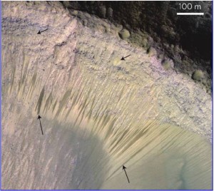
NASA Mars Reconnaissance Orbiter’s HiRISE image of Recurring Slope Lineae (RSL) in Melas Chasma, Valles Marineris. Arrows point out tops and bottoms of a few lineae.
Credit: NASA/JPL-Caltech/University of Arizona
Enigmatic features
New research is underway to mimic sites on Mars that could harbor microbiota today, places on the planet that contain transient or permanent liquid water near the martian surface – such as those enigmatic Recurring Slope Lineae. RSL could be shallow, subsurface liquid brines that slowly move down slope.
For more details, go to my new Space.com story:
Cold World, Hot Topic: Can Microbes Survive on Mars?
https://www.space.com/38193-can-microbes-survive-on-mars.html

Credit: ESA – P.Carril
What do we need to know to mine an asteroid?
To make this concept a reality there’s need to increase knowledge regarding the very diverse population of accessible Near Earth Asteroids (NEA).
Last year, dozens of the world’s leading asteroid scientists and asteroid mining entrepreneurs came together in Luxembourg to discuss key questions and identify scientific knowledge gaps.
A just-issued White Paper outline the results of that discussion — “Answers to Questions from the Asteroid Miners” – and has been presented at the European Planetary Science Congress (EPSC) 2017 in Riga now underway.

Hand over hand contact with asteroids – part of our future?
Credit: NASA
Roadmap
The White Paper covers questions surrounding the need for asteroid surveys in preparing for mining missions, the asteroid’s surface and interior, implications for astrobiology and planetary protection and other questions relating to policy and strategy for developing a roadmap for advancing asteroid in-space resource utilization.
For example, asteroid miners looking for water to use in rocket fuel or life support systems, being able to identify the class of asteroid is vital.
Furthermore, comprehensive knowledge of regolith properties at asteroids’ surface and subsurface will be vital for developing strategies for landing and extracting materials. However, as yet, no mission has explored how asteroid regolith might vary with depth.

Asteroid Ida
Credit: NASA/PL
Potential targets
“Aside from samples returned from a handful of missions, the only way we can study the composition of asteroids is by analyzing light reflected from their surfaces, or by examining fragments that have landed on Earth in the form of meteorites,” says lead White Paper author, Amara Graps of the University of Latvia and the Planetary Science Institute, Tucson, Arizona.
A number of knowledge gaps were identified: the asteroid miners need access to a map of known NEAs with an orbit similar to the Earth so that they can fine-tune their selection of potential targets.
Many objects are – as yet – undiscovered or very little is known about them, so there is also a need to develop a dedicated NEA discovery and follow-up program.

Business plan for asteroid mining.
Credit: Joel Sercel/ICS Associates Inc. and TransAstra
Action-reaction

We have never seen inside of an asteroid. Which is it?
Credit: Walker et al., 2006 and Murdoch, 2016
“Asteroid mining techniques will need to adapt to the low-gravity environment. Possible solutions include cancelling out action-reaction forces by digging in opposite directions at the same time, or by producing a reaction force, such as by strapping a net around the asteroid for robots to grab onto while they dig,” says J. L. Galache of Aten Engineering, an asteroid “astropreneur” and contributor to the White Paper. “It’s a challenge! But answering the questions posed in this White Paper will be an important first step.”
Resources
Questions from the asteroid mining companies have been sorted into the three asteroid science themes: 1) survey, 2) surface and 3) subsurface and 4) Other.
The answers to those questions have been provided in the Asteroid Science Intersections with In-‐Space Mine Engineering (ASIME) 2016 White Paper: In-Space Utilization of Asteroids: “Answers to Questions from the Asteroid Miners”
Go to:
https://arxiv.org/abs/1612.00709

Blue Origin’s crew capsule – a suborbital six-seater craft.
Credit: Blue Origin
Question: “As you may know, a number of private companies are experimenting with individual space travel. If you could afford it, how likely would you be to travel to space?”
Taking a new public pulse regarding this question is a Sept. 7-11 Morning Consult/POLITICO poll.
Explains Edward Graham, a reporter at Morning Consult covering tech policy: Forty-one percent of registered voters said they were likely to travel to space if they could afford it. A 48-percent plurality said they were not too likely or not at all likely to do so, even if they had the means.
Eleven percent didn’t know or had no opinion, according to the national sample of 1,975 voters. The survey has a margin of error of plus or minus 2 percentage points.

Sir Richard Branson, founder of Virgin Galactic takes flight. Will public space travel?
Credit: Virgin Galactic
Underwhelming prospect
Graham points out that Elon Musk’s Space Exploration Technologies Corp., Jeff Bezos’ Blue Origin and Richard Branson’s Virgin Galactic are pursuing expensive private space travel efforts.

Public pulse on space travel – sample page from new poll.
Credit: Morning Consult/POLITICO poll.
“Some Americans seem underwhelmed by the possibility of affordable private-sector space travel,” Graham explains, “even as the industry sets its sights on loftier goals than shepherding wealthy clients into outer space.”
Of those poll respondents with yearly incomes of $100,000 or more, 40 percent said they were likely to travel to space if they could afford it, Graham reports. “Fifty-five percent of respondents in that income bracket said they were unlikely or not too likely to make the journey, even if it was within their budget.”
Resources
For Graham’s full story on the poll findings, go to:
For the poll questions that were asked, including the public space travel query, go to:
https://morningconsult.com/wp-content/uploads/2017/09/National-Tracking-Poll-170904.pdf

Credit: NASA
They are dubbed “vibrotactile boots.”
New work at Draper Labs in Cambridge, Massachusetts makes use of sensors at the front of the boot to detect obstacles and alert the user through a combination of visual signals and vibrations applied to the feet.
Alison Gibson of Draper says her “booted” system of knowing the position of your legs on Mars can be challenging while wearing a bulky pressurized suit. Also, altered gravity high-stepping across Mars certainly doesn’t help.
Footnote: task at hand
According to Andrea Webb of Draper, “the system allows astronauts to focus on the task at hand instead of watching the ground,” she said in a press statement.
Solid footing on Mars can be a real challenge, where reduced gravity and the constraints of a bulky pressured suit limit sensory feedback.

Credit: Dan Durda
Also, the protective helmet further limits an astronaut’s peripheral vision, forcing space explorers to lean forward and look down to see tripping hazards. In this environment, a punctured suit or damaged life support system can be fatal.
New approach
Point is, Draper researchers studied this problem and developed a new approach for how astronauts see and feel the terrain around them. By equipping a special boot with built-in sensors and tiny haptic motors that vibrate, the research team aims to give astronauts the information they need to stay safe.
“The boots have built-in sensors and vibration motors, all connected to a small microcontroller that processes the sensor data and determines which cue to send to the user,” says Alison Gibson, a Draper Fellow and former graduate student in MIT’s Department of Aeronautics and Astronautics.
Credit: Bob Sauls – XP4D/Explore Mars, Inc. (used with permission)
Vibratory feedback
Gibson further advises that the front of each boot contains an ultrasonic range-finder, a proximity sensor and a six degree-of-freedom Inertial Measurement Unit. The vibratory feedback delivered to the feet is supplemented with an augmented reality visual display that also indicates the location and proximity of approaching obstacles.
Draper and MIT research in this area could have applications in the design of navigation systems for the visually impaired, and serve as an added safety measure for first responders and firefighters as they navigate smoke-filled rooms, according to the Draper press statement.

Curiosity image of wheel – coated with Mars mud?
Credit: NASA/JPL
There is increasing discussion and debate concerning the exploration of Mars and how best to search for past/present life on the Red Planet.
One element of the deliberation is what constitutes a “Special Region” on Mars.

This series of images spans a period of 15 weeks shows a pair of fresh, middle-latitude craters on Mars. The bright material is water ice that was uncovered by the meteorite impact. Sublimation of the ice during the Martian summer leaves behind a dust layer that gradually thickens to the point where it obscures the ice. The impact responsible for these craters had not yet occurred by June 4, 2008, but had occurred by Aug. 10, 2008.
Credit: NASA/JPL-Caltech/University of Arizona
A Special Region is a region classified by the Committee on Space Research (COSPAR) where terrestrial organisms might readily propagate, or thought to have a high potential for existence of Martian life forms. This is understood to apply to a region on the Red Planet where liquid water occurs, or can occasionally happen, centered on our current understanding of requirements for life.
Impact craters
“I think many of the recent Martian meteorite impact craters imaged by Mars Reconnaissance Orbiter showing white ice in the interior of freshly exposed craters and their ejecta blanket should give us pause as to what ‘Special Regions’ on Mars are,” says Barry E. DiGregorio, director for the International Committee Against Mars Sample Return (ICAMSR). “In fact, every time I look into the night sky and see Mars,” he adds, “I think I am looking at a ‘Special Region.’”

The bright material conspicuous in this image was excavated from below the surface and deposited nearby by a 2008 impact that dug a crater about 8 meters (26 feet) in diameter. The extent of the bright patch was large enough for the Compact Reconnaissance Imaging Spectrometer for Mars, an instrument on NASA’s Mars Reconnaissance Orbiter, to obtain information confirming the material to be water ice.
Credit: NASA/JPL-Caltech/University of Arizona
DiGregorio suggests that no one at NASA can be sure that a rover or lander has not been inadvertently sent to a Special Region where wet zones persist.
“That’s because we apparently can’t detect the nearness of small amounts of evaporating water ice moving through the top soil or regolith,” DiGregorio notes.

Credit: NASA/JPL
Wheel proof – wet soil?
To enhance his case, DiGregorio points to images relayed from NASA’s Curiosity Mars rover. The images were acquired via the robot’s Mastcam camera on Sol’s 528-532.
“As you can see, the ‘soil’ adhering to the wheels is mud-like and wet – similar to a wet clay. So here you have an incident where Curiosity drove right over the top of a Special Region zone and it went unreported – until now,” DiGregorio concludes.
Clingons!

Murray Buttes and Mars explorer.
Artwork credit: Sean Doran
Resources
The pages of the Astrobiology journal have served as the epicenter of new, on-going dialogue regarding future exploration of Mars and the search for life on that distant world.
Go to:
Searching for Life on Mars Before It Is Too Late
http://online.liebertpub.com/doi/full/10.1089/ast.2017.1703
Four Fallacies and an Oversight: Searching for Martian Life
http://online.liebertpub.com/doi/pdfplus/10.1089/ast.2017.1749

