Archive for 2015

You could consider them trial balloons, in the juggernaut jargon of Washington, D.C. politics.
The prospect that China may be invited to climb onboard the International Space Station seems airborne for discussion.
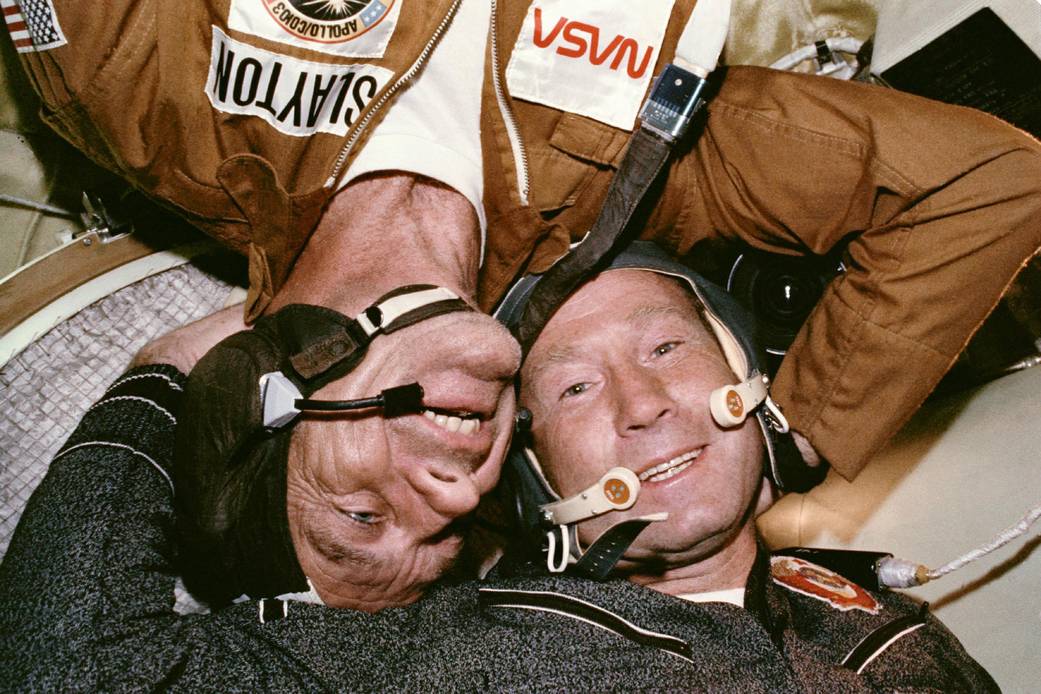
Apollo-Soyuz link-up: On July 17, 1975 two Cold War-rivals met in space.
Credit: NASA
No telling, but perhaps the overtures are just in time for the 40th anniversary of the joint Apollo-Soyuz (U.S.-Russia) mission in 1975 this coming July?
My colleague, co-author of Mission to Mars: My Vision for Space Exploration, Apollo 11’s Buzz Aldrin, is a firm supporter of this idea. Check out the just-released paperback with a new, special essay.
Inside Space City
There are a number of opinion pieces, broadcasts, and reports worth reading about such a possibility.
For example, take a view of “Inside Space City,” a world exclusive CNN interview with three of China’s top astronauts with one Chinese astronaut calling for cooperation, access to International Space Station.
Go to:
http://www.cnn.com/2015/05/28/asia/china-space-mckenzie/index.html
Also, take a read of “The Silly Reason the Chinese Aren’t Allowed on the Space Station,” by Jeffrey Kluger, Editor at Large for TIME magazine.
Go to:
http://time.com/3901419/space-station-no-chinese/#3901419/space-station-no-chinese/

Chinese space travelers in training.
Credit: CMSE
Divergent views
Should the United States cooperate with China in Space? That question is explored by a recent paper, authored by Ronald Turner of Analytic Services Inc.
This paper explores the rationales behind the two divergent views on U.S.-China cooperation in space, and suggests that limited engagement with the Chinese, through NASA, would benefit the United States.
Turner flags two specific near-term objectives that should be considered by the United States:
— Join the European Space Agency in ongoing discussions with the Chinese for joint space science in the next five years
— Invite a Chinese astronaut to the International Space Station
This paper is available at:
http://www.anser.org/babrief-us-china-space-coop

The International Space Station: Open airlock for Chinese space travelers?
Credit: NASA
China Dream, Space Dream
China’s progress in space technologies and implications for the United States is explored in a study by the University of California’s Institute on Global Conflict and Cooperation (IGCC).
Authored by Kevin Pollpeter, Eric Anderson, Jordan Wilson, and Fan Yang of the IGCC, they point out that “although China’s space program may pose challenges for the United States and its space power neighbors, it may also present opportunities for scientific collaboration on the Earth’s environment and outer space. In addition, it may make human spaceflight safer by providing additional capabilities to rescue stranded or imperiled astronauts through the use of common docking apparatus.”
This paper can be found here:
http://origin.www.uscc.gov/sites/default/files/Research/China%20Dream%20Space%20Dream_Report.pdf
Bottom line
Meanwhile, China is readying the Tiangong-2 space lab to be lofted around 2016, say Chinese space officials.
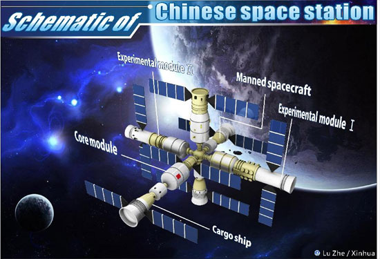
China’s space station in the 2020s.
Credit: CASC
Once that facility is in Earth orbit it will be followed by a piloted Shenzhou-11 spacecraft and first use of the Tianzhou cargo craft to rendezvous with and support lab operations.A core module for a larger space station is also on China’s agenda, to be lofted around 2018. That station is expected to be completed around 2022.
Back to orbiting olive branches between two space powers.
There’s a possible bottom line to all this: A convergence of coincidence or a lead-lined trial balloon that’s DOL – “doomed on liftoff?”
You be the judge and please share your opinions!

The Low-Density Supersonic Decelerator (LDSD) test vehicle is seen during the full mission dress rehearsal, Friday, May 29, 2015, at the U.S. Navy Pacific Missile Range Facility (PMRF) in Kauai, HI. The LDSD crosscutting technology demonstration mission will test breakthrough entry, descent and landing technologies that will enable large payloads to be landed safely on the surface of Mars.
Credit: (NASA/Bill Ingalls)
The second flight test of NASA’s Low-Density Supersonic Decelerator (LDSD) now will launch no earlier than 10:30 a.m. PDT (1:30 p.m. EDT, or 7:30 a.m. HST) Tuesday, June 2, from the U.S. Navy’s Pacific Missile Range Facility (PMRF) on Kauai, Hawaii.
NASA Television coverage will begin at 10 a.m. PDT (1 p.m. EDT, or 7 a.m. HST) and go to:
http://www.nasa.gov/multimedia/nasatv/
NASA’s LDSD project is designed to investigate and test breakthrough technologies for landing future robotic and human Mars missions and safely returning large payloads to Earth.

The Moon sets during the full mission dress rehearsal for the Low-Density Supersonic Decelerator (LDSD), Friday, May 29, 2015, U.S. Navy Pacific Missile Range Facility (PMRF) in Kauai, HI. The LDSD crosscutting technology demonstration mission will test breakthrough entry, descent and landing technologies that will enable large payloads to be landed safely on the surface of Mars.
Credit: (NASA/Bill Ingalls)
The test, performed over the Pacific Ocean, will simulate the supersonic entry and descent speeds at which the spacecraft would be traveling through the Martian atmosphere.
NASA’s LDSD program is part of the agency’s Space Technology Mission Directorate in Washington, which innovates, develops, tests and flies hardware for NASA’s future missions.

A United Launch Alliance (ULA) Atlas V rocket successfully launched the U.S. Air Force X-37B space plane on May 20.
Credit: ULA
A global team of vigilant satellite watchers has spotted the Air Force’s unpiloted winged craft, the X-37B space plane, now circling the Earth on its fourth Orbital Test Vehicle mission (OTV-4).
Operated by the U.S. Air Force’s Rapid Capabilities Office, the secretive robotic spacecraft was orbited on May 20 by a United Launch Alliance Atlas V 501 booster from Cape Canaveral Air Force Station, Florida.

Previous mission photo shows launch processing of a Boeing-built X-37B Orbital Test Vehicle.
Credit: Boeing
The rapid discovery of OTV-4 in orbit has already led to some interesting facts.
For my new story on sighting the space plane, go to:
Air Force’s Mysterious X-37B Space Plane Spotted by Amateur Astronomers
by Leonard David, Space.com’s Space Insider Columnist
May 29, 2015 07:00am ET
http://www.space.com/29516-x37b-space-plane-amateur-photos.html

This image was taken by Curiosity’s Mastcam: Right on May 27, 2015 on Sol 997.
Credit: NASA/JPL-Caltech/MSSS
NASA’s Curiosity Mars rover has wheeled into position to investigate several different rock units in Marias Pass.
The robot is to use a number of instruments on its arm, notes Lauren Edgar, Mars Science Laboratory science team member and research geologist at the U.S. Geological Survey’s Astrogeology Science Center in Flagstaff, Arizona.

Curiosity’s Navcam: Left B shows outstretched and instrumented robot arm on May 28, 2015, Sol 998.
Credit: NASA/JPL-Caltech
“We are parked in front of a beautiful outcrop that shows the contact between the underlying Pahrump unit and the overlying Stimson unit,” she explains.
Sounds of silence
Curiosity will be parked for the next few weeks, Edgar adds. That’s due to the upcoming solar conjunction. Mars will be on the opposite side of the Sun from the Earth. That alignment means there will be no contact with the rover for most of June.
Similarly, NASA’s Opportunity Mars rover will enter radio silence.
The rover’s recent drive of 8 feet (2.5) meters brings its total odometry to 34,774 feet (10,599 meters) or roughly 7 miles since the Mars machinery landed in August 2012.
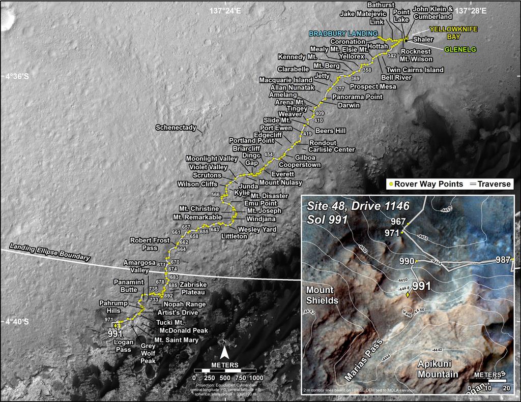
This map shows the route driven by NASA’s Mars rover Curiosity through the 991 Martian day, or Sol, of the rover’s mission on Mars (May, 21, 2015).
Numbering of the dots along the line indicate the sol number of each drive. North is up. The scale bar is 1 kilometer ( roughly 0.62 mile). From Sol 990 to Sol 991, Curiosity had driven a straight line distance of about 61.85 feet (18.85 meters).
The base image from the map is from the High Resolution Imaging Science Experiment Camera (HiRISE) in NASA’s Mars Reconnaissance Orbiter.
Credit: NASA/JPL-Caltech/Univ. of Arizona

Credit: Virgin Galactic
Sir Richard Branson’s Virgin Galactic team in Mojave, California is reporting progress in building the second SpaceShipTwo.
It has been over six months since the tragic mishap involving the first SpaceShipTwo – VSS Enterprise – took the life of pilot Michael Alsbury as the craft broke apart during its 55th test flight on October 31, 2014.
Virgin Galactic reports that the new vehicle — not yet been formally named — is coming along “at a steady pace, thanks to the efforts of the women and men in our manufacturing organization, The Spaceship Company.”

Second SpaceShipTwo taking shape.
Credit: Virgin Galactic
Work is underway on the second craft in three shifts, spanning days, nights, and weekends, the company reports.
In recent weeks, workers have completed the final cure cycle of the main cabin, closed out the main portions of the wings, and completed other key steps in the build plan.
Test plan
A milestone has been recently met: taking the new spaceship off of the construction fixtures and placing the craft on its own landing gear.
The spaceship will remain in the hangar for some time after that, occasionally moving back onto and back off the fixture as workers continue to install new items and testing and verifying every piece of the craft.

On its wheels for the first time – second SpaceShipTwo.
Credit: Virgin Galactic
“Our hope is that the second SpaceShipTwo will enter into testing later this year,” Virgin Galactic’s website adds, “beginning with ground testing, then progressing through captive carry flights, glide flights, and eventually powered flights to progressively higher speeds and altitudes.”
For a video look at aspects of the Virgin Galactic SpaceShipTwo program and pursuing public space travel, go to:
Virgin Galactic – Introducing our Spaceship Propulsion Team at:
https://www.youtube.com/watch?v=euCsIwAoElI#t=11
Virgin Galactic Space Tourism – an informative documentary by Science & Technology 4U, published on Dec 29, 2014 at:

Curiosity Mars rover made use of its Mastcam: Left camera to take this image on May 25, Sol 995.
Image Credit: NASA/JPL-Caltech/MSSS
NASA’s Curiosity Mars rover has been characterizing the terrain and bedrock exposed in Marias Pass.
The robot’s recent drive has set in motion up close study of the contact between two different types of bedrock: the underlying Pahrump unit and the overlying Stimson unit.
That’s the word from Lauren Edgar, Mars Science Laboratory science team member and research geologist at the U.S. Geological Survey’s Astrogeology Science Center in Flagstaff, Arizona.
Curiosity draws closer to explore two different types of bedrock, as seen in this Navcam Left B image taken on May 27 on Sol 997.
Image Credit: NASA/JPL-Caltech
Edgar said the plan now is focused on characterizing the contact in this new location, “and then bumping even closer to the outcrop to prepare for contact science” this week.
Dust devils, Phobos and Deimos
Curiosity’s ChemCam instrument is slated to assess the chemistry on either side of the contact.
The plan also includes some Mastcam mosaics to document the sedimentary structures, Edgar adds. Using Navcam observations, the search is also on for whirling dust devils in the area.
By Curiosity bumping up ever-closer to the outcrop the Mars machinery will acquire images for future targeting.
In an overnight duty, Curiosity is to acquire Mastcam images of Phobos to study aerosols in the atmosphere of Mars. Earlier, on Sol 995, Curiosity was to acquire several Mastcam observations of Deimos and stars to assess the nighttime atmospheric opacity.
A United Launch Alliance (ULA) Atlas V rocket successfully launched the U.S. Air Force X-37B space plane on May 20.
Credit: ULA
The U.S. Air Force’s Rapid Capabilities Office is flying the fourth mission of the X-37B Orbital Test Vehicle (OTV) – the military’s secretive robotic space plane.
The reusable and unpiloted winged craft was orbited on May 20 by a United Launch Alliance Atlas V 501 booster on an AFSPC-5 mission from Cape Canaveral Air Force Station, Florida.

Credit: ULA
The X-37B is built by Boeing Network & Space Systems, the same unit that designs and delivers satellites used for communications, navigation, intelligence, and weather monitoring.
Only two X-37B vehicles have been confirmed as being built.
The first OTV mission began April 22, 2010, and concluded on Dec. 3, 2010, after 224 days in orbit. The second OTV mission began March 5, 2011, and concluded on June 16, 2012, after 468 days on orbit. The X-37B program completed its third mission on October 17, 2014 landing after 674 days on-orbit.

A third mission of the Boeing-built X-37B Orbital Test Vehicle was completed on Oct. 17, 2014, when it landed and was recovered at Vandenberg Air Force Base in California following a successful 674-day space mission. The upcoming space plane flight – on the program’s fourth mission — may land at the Kennedy Space Center in Florida.
Credit: Boeing
How many days the currently flying OTV-4 mission will chalk up is unknown.
The recent Atlas V mission also included use of the Aft Bulkhead Carrier (ABC) carrying the National Reconnaissance Office’s (NRO’s) Ultra Lightweight Technology and Research Auxiliary Satellite (ULTRASat).
ULTRASat is composed of 10 CubeSats managed by the National Reconnaissance Office (NRO) and NASA.
The ABC contained 8 P-Pods that released 10 CubeSats developed by the U.S Naval Academy, the Aerospace Corporation, Air Force Research Laboratory, The Planetary Society and California Polytechnic, San Luis Obispo.
NOTE: A new and informative video on the Boeing-built X-37B has been released and can be viewed here:
http://www.space.com/29479-x-37b-space-plane-s-capabilities-explained-by-boeing-video.html

The lunar far side as imaged by NASA’s Lunar Reconnaissance Orbiter using its LROC Wide Angle Camera.
Credit: NASA/Goddard/Arizona State University
Recent word from Chinese space officials is that the country’s Chang’e-4 lunar probe will likely be targeted for a far side Moon landing.
Wu Weiren, the chief engineer for China’s Lunar Exploration Program was quoted as telling Chinese Central Television: “We probably will choose a site on which it is more difficult to land and more technically challenging…Our next move will probably see some spacecraft land on the far side of the moon,” Wu said.
Some reports say that Chang’e-4 will orbit the Moon before sending a rover to the surface, possibly on the so far unexplored far side for the first time. Space project officials add that the “dark” side of the Moon is not dark. Rather, the far side receives sunlight as does the hemisphere that can be seen from Earth.
Chang’e-4 began as a backup probe for Chang’e-3. Since Chang’e-3’s lander and rover successfully landed on the moon in 2013, Chang’e-4 was to be given a new mission, which was to be decided after more study.
Pilot program
Last March, the State Administration of Science, Technology and Industry for National Defense (SASTIND) explained that China will launch its Chang’e-4 lunar probe before 2020.
Furthermore, that lunar mission will pilot a program that uses private investment from individuals and enterprises for the first time, said SASTIND.
Doing so is aimed at accelerating aerospace innovation, cutting production costs and promoting military-civilian relationships, said SASTIND, as reported by China’s state-run Xinhua News Agency.

Logo for the Chinese Lunar Exploration Program (CLEP)
Credit: CLEP
Track record
China’s lunar exploration program is divided into three stages: orbiting, landing and return.
China launched its first lunar probe, Chang’e-1, in October 2007, completing a 16-month imaging mission and was crashed into the Moon’s surface.
Chang’e-2 was launched in October 2010. After wrapping up its primary Moon-orbiting duties, the probe left lunar orbit for the Earth–Sun L2 Lagrangian point. It departed L2 and flew by asteroid 4179 Toutatis, one leg of a long-term mission to verify China’s deep-space tracking and control systems.

Group shot…China’s Chang’e 3 lander and Yutu rover.
Credit: Chinese Academy of Sciences
Chang’e 3was launched in December 2013 and marked the completion of the second stage of the country’s lunar program. A hefty lander touched down on the Moon, deploying the Yutu lunar rover.
Lunar sampling
A test capsule – mounted on a service module spacecraft and labeled by some as Chang’e 5-T1 — was hurled moonward in October 2014 and placed on a circumlunar trajectory.

Following circumlunar voyage, return capsule parachuted to Earth.
Courtesy: China Space
The Chang’e 5-T1 craft chalked up nearly 196 hours of flight before releasing its capsule companion to make a fiery, skip re-entry and parachute landing on Earth. The capsule verified its use for China’s future lunar sample return effort, Chang’e-5, slated for flight in 2017.
The service module – after dropping off the test capsule — was then guided to the Earth-Moon Lagrangian (L2) position, completing three circles around that point and was later maneuvered into lunar orbit.
China/Russia space plans?
In a May 25 story from Russia’s TASS news agency, China and Russia have agreed to cooperate on future space endeavors, including a human mission to the Moon.
Citing an unnamed source, TASS reported that the two countries would develop common standards for docking hardware, electrical connectors and spacecraft atmospheres.

Credit: Mohammed bin Rashid Space Centre
The United Arab Emirates’ UAE Space Agency will launch its official strategy and operational plan in Abu Dhabi on May 25.
The strategy puts in motion developing the space sector, creating space policy and regulation, and directing national space programs that will benefit the UAE’s economy and develop human capital.

Credit: UAE Space Agency
Also to be staged in Abu Dhabi is a Global Space and Satellite Forum, to be held May 26-27. That event is hosted by the Mohammed Bin Rashid Space Center with the endorsement of the UAE Space Agency and aims to gather key regional and international stakeholders and decision makers from the space and satellite industry.
A major element of UAE Space Agency is to send a robotic space probe – called “Hope” — to Mars by 2021- the UAE’s 50th anniversary.
The UAE government has already invested 5.4 billion U.S. dollars in space technologies, and about 150 Emirati scientists and engineers will participate in the mission.
Science at Mars
The probe will create mankind’s first integrated model of the Red Planet’s atmosphere. The spacecraft will collect and send back to earth over 1,000 gigabytes of new Mars data. This information will be received in the Science Data Centre in the UAE through different ground stations spread around the world.

The spacecraft will carry to the Red Planet a suite of science Instruments:
— Imager: a digital camera that sends back high-resolution color images
— Infrared Spectrometer: to examine temperature patterns, ice, water vapor and dust in the Martian atmosphere
— Ultraviolet Spectrometer: to study Mars’ upper atmosphere and traces of oxygen and hydrogen further out into space.
Strategic partnership
In a related development, France and the UAE, the UAE Space Agency and the Centre National d’EtudesSpatiales, (the National Centre of Space Studies of France) also known as CNES, recently signed a Memorandum of Understanding (MoU) to create a strategic space partnership between the two entities.

Credit: Mohammed bin Rashid Space Centre
The agreement represents the UAE Space Agency’s first international Memorandum of Understanding with a foreign agency for partnership and cooperation in space.
For an informative video regarding the UAE Space Agency’s Mars mission, go to:
https://www.youtube.com/watch?v=ZHen3W3g0K0#t=22
Also, go to this special website:

The Optical Orbital Debris Spotter is capable of detecting debris with sizes as small as about 0.01 centimeters in the vicinity of a host spacecraft for near real-time damage attribution and characterization of dense debris fields.
Credit: Naval Research Laboratory (NRL)
Earth orbiting clutter comes in all sizes: upper stages to paint chips to small shards of spacecraft leftovers.
The number of human-made debris objects orbiting the Earth continues to increase at a worrisome rate, with objects smaller than one centimeter (cm) exceeding 100 million.
Put at risk from some high-speed flotsam are operating satellites and human-carrying vessels like the International Space Station.
Enter researchers at the U.S. Naval Research Laboratory (NRL) that have received a U.S. patent for the Optical Orbital Debris Spotter. The small sensor can potentially provide additional data to complement existing debris models such as the Space Surveillance Network (SSN).
The Optical Orbital Debris Spotter is a compact, low power, low cost, local space debris detection concept that can be integrated into larger satellite designs, or flown independently on-board nano-satellite platforms.
Light sheet
According to a NRL press statement, the key idea of this concept is to form a permanently illuminated light sheet rather than scanning a beam. Doing so — to create a continuous light sheet – makes use of a collimated light source, such as a low power laser, and a conic mirror.
“When the flight path of an orbital debris object intersects the light sheet, the object will scatter the light, and a portion of that scattered light can be detected by a wide angle camera,” explains Christoph Englert, research physicist at NRL. Assimilating that data, the Spotter could divine the size, and shape information about the debris particle, he adds.

Clutter in the cosmos.
Credit: Used with permission: Melrae Pictures/Space Junk 3D
Lots of litter
The Optical Orbital Debris Spotter would be a busy piece of equipment.
The SSN now tracks more than 16,000 objects orbiting Earth. About five percent of those being tracked are functioning payloads or satellites, eight percent are rocket bodies, and about 87 percent are debris and/or inactive satellites, notes NRL.
This newly patented idea is a small, stand-alone sensor system and could also be deployed within a debris cloud to provide in-situ measurements of debris density, distribution and evolution.
“Using a dedicated nano-satellite, or CubeSat, the system could be used for the gathering of more comprehensive debris field data,” Englert says.
These data sets could then be incorporated into global space tracking tools such as the Space Surveillance Network (SSN), NASA’s Orbital Debris Engineering Model (ORDEM), and the European Space Agency’s Optical Ground Station.

