Archive for 2015

This composite image looks toward the higher regions of Mount Sharp within Gale Crater,
Credit: NASA/JPL-Caltech
This composite image looking toward the higher regions of Mount Sharp within Gale Crater was taken on September 9, 2015 by NASA’s Curiosity Mars rover and released by the Jet Propulsion Laboratory (JPL) last week.
In the foreground — about 2 miles (3 kilometers) from the rover — is a long ridge teeming with hematite, an iron oxide. Just beyond is an undulating plain rich in clay minerals. And just beyond in this photo re a multitude of rounded buttes – all high in sulfate minerals.
Further back in the image are striking, light-toned cliffs in rock that may have formed in drier times and now is heavily eroded by winds.
“The changing mineralogy in these layers of Mount Sharp suggests a changing environment in early Mars, though all involve exposure to water billions of years ago,” explains the JPL Curiosity website.
Grey Mars
It may not be 50 shades of grey.

Grey Mars as imaged by Curiosity’s Mastcam Right, snapped on September 30, 2015, Sol 1120.
Credit: NASA/JPL-Caltech/MSSS
But I asked noted Marsologist, Chris McKay at the NASA Ames Research Center in California about “the greying of Mars” – what’s going on?
“I list the ‘grey Mars’ as one of the four major results of Curiosity – nitrates, fluoride, meteroritic-like organics are the other three,” McKay told Inside Outer Space.
McKay said that virtually all other Mars missions have only accessed the surface of “red Mars.”
Mars stinks!
“The non-porous mudstone at Gale Crater has provided a way to easily reach ‘grey Mars’…even with the rather wimpy drill on Curiosity,” McKay said.
As expected, McKay points out, grey Mars releases Hydrogen sulfide (H2S) when heated and it smells like rotten eggs.
“Unexpectedly it is low in organics — although some are found in Cumberland and has perchlorate,” McKay notes. “I think this is due to cosmic radiation and implies that we need to drill deeper to find pristine grey Mars – probably 16 feet (5 meters) deep at the Yellowknife Bay site.”
Methane measurement
In related news about the new drill hole and tailings: The weekend plan called for an after dusk use of the Mars Hand Lens Imager (MAHLI). That instrument will make use of its LEDs to look inside of the drill hole and image the drill tailings.

This image was taken by ChemCam: Remote Micro-Imager onboard NASA’s Mars rover Curiosity on October 4, 2015, Sol 1123.
ChemCam fires a laser and analyzes the elemental composition of vaporized materials from areas smaller than 1 millimeter on the surface of Martian rocks and soils.
Credit: NASA/JPL-Caltech/LANL
That operation is to be followed by use of the Alpha Particle X-Ray Spectrometer (APXS) and placing that device over the tailings for an overnight measurement.
MAHLI is also slated to image the pre-sieve dump pile and APXS will be placed over it for another overnight integration.
The Sample Analysis at Mars (SAM) Instrument Suite is to be used for an atmospheric methane measurement. SAM is being put to use because Mars recently went through the path of comet Damocles.
“Dust ejected from comets is often carbon-rich, and therefore is a possible source of the elevated methane concentration that has occasionally been observed by SAM,” explains Ken Herkenhoff of the USGS Astrogeology Science Center in Flagstaff, Arizona.

Credit: Space Telescope Science Institute
Survey information by YouGov research reveals that majorities of the public in Britain, Germany and the U.S. believe that living creatures who have the ability to communicate and do not come from Earth do exist.
“You are not alone: most people believe that aliens exist” is the title of the YouGov data set posted last month by the group’s Will Dahlgreen.

Fermi Paradox: Where are they?
YouGov notes that Stephen Hawking has described the search for extra-terrestrial life as “the most exciting quest in 21st-century science” and backed a new project, the Breakthrough Initiative. It is the largest effort yet to search for alien intelligence.
A particularly interesting aspect of the research focuses on the Fermi Paradox.
The Fermi Paradox explores the idea that the lack of evidence for intelligent life contradicts the incredibly low chance that ours is the only planet where it exists in the 1,000,000,000,000,000,000,000,000 planet universe.
Among Americans who believe in extra-terrestrial life, backwards human technology (42%) is the reason why we have not contacted other intelligent life forms, YouGov finds.

Concealing contact
As noted in the research, one conspiratorial possibility is that we have contacted intelligent life but the government has covered it up.
Nearly a third of Americans (30%) believe that the government has deliberately concealed contact with aliens from us.
The research also looks into the recently announced project by the Breakthrough Initiative that aims to send a digital message describing life on Earth to other intelligent civilizations distant from our planet.
“Scientists are now unsure on whether they should contact extra-terrestrial intelligent life,” observes YouGov.
Digital message
“The question still remains of whether it’s a good idea to even try to contact alien life – Hollywood at least would suggest it probably is not,” the YouGov research explains.

Green Bank Telescope (GBT) will join in the search, receiving roughly $2 million per year for 5 years. The 100-meter GBT is the world’s largest fully steerable radio telescope, located in West Virginia.
Credit: NSF
The YouGov question asked: On balance, do you think the digital message should be sent?
Their finding: Americans tend to say we should send a digital message describing life on Earth to other civilizations.
However, (43% say we should, 31% say we should not) and men (48%) are more supportive on the idea than women (39%).
Resources
YouGov is a leading online market research company based in the UK.
“Our mission is to supply a live stream of continuous and accurate data and insight into what people are thinking and doing all over the world, all of the time, so that companies, governments and institutions can better serve the people that sustain them.”
The new research on ET contact involved a sample of 1,000 adult interviews carried out September 14 – 16, 2015.
For full details on this intriguing YouGov ET survey, go to:
https://today.yougov.com/news/2015/09/28/you-are-not-alone-most-people-believe-aliens-exist/
Also go to:
Breakthrough Search for ET: A “Major Escalation” in Looking for Other Starfolk
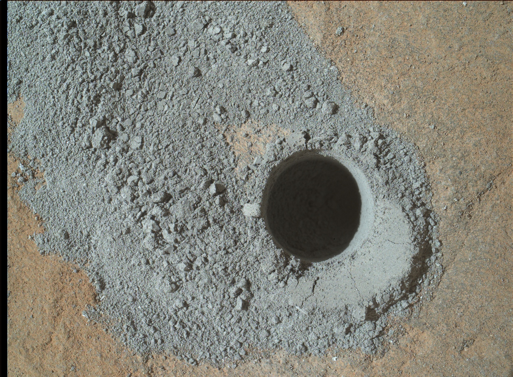
Big Sky drilling result. NASA’s Mars rover Curiosity acquired this image using its Mars Hand Lens Imager (MAHLI), located on the turret at the end of the rover’s robotic arm, on September 29, 2015, Sol 1119 of the Mars Science Laboratory Mission.
Credit: NASA/JPL-Caltech/MSSS
NASA’s Curiosity Mars rover has entered Sol 1122, landing on the Red Planet back in August 2012.
Operators of the Mars machinery are reporting success in using the rover’s drill on “Big Sky.”
It went perfectly, reports Ryan Anderson, a planetary scientist at the USGS Astrogeology Science Center in Flagstaff, Arizona and a member of the ChemCam team on the Mars Science Laboratory mission.
Minerals on Mars
The plan called for the rover to transfer some of the powder from Big Sky to the Chemistry and Mineralogy instrument, or CheMin for short. That instrument is built to identify and measure the abundances of various minerals on Mars.
Also on Sol 1121, the Chemistry & Camera (ChemCam) was slated to observe the target “Minnekahta.”
The rover’s Mastcam was scheduled to document the ChemCam location and also take a picture of the location on the ground where Big Sky material will be dumped, Anderson explains.
Search for clouds
On Sol 1122, Anderson said ChemCam would observe targets “Kippen,” “Kalispell,” and “Big Snowies.”
Anderson adds that Mastcam is to document these targets and take a 4×1 mosaic of the lower portion of Mt. Sharp. Also, Navcam will be used to take a movie about the northern rim of Gale crater to search for any clouds.
“We are all eagerly looking forward to the CheMin results from Big Sky,” Anderson concludes, “to compare with our previous results from ‘Buckskin!’”
Implementation of planned rover activity is subject to change due to a variety of factors related to the Martian environment, communication relays and rover status.
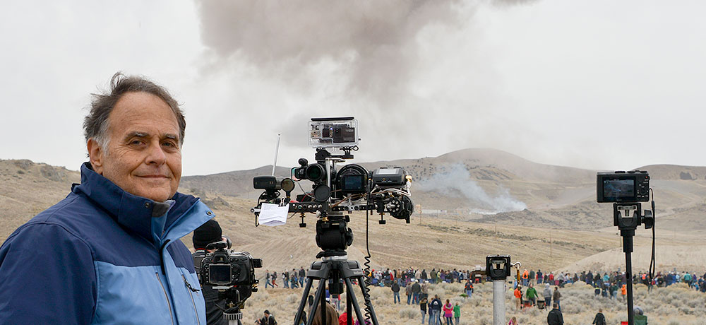
Inventor Dan Slater uses Remote Acoustic Sensor (RAS) technology during a test firing of the five-segment rocket motor headed for use on NASA’s Space Launch System booster.
Credit: Sandy Slater
A novel technique is being tested to visually and audio-record scenes ranging from exo-atmospheric rocket events to microbial life on other worlds.
Tagged as a Remote Acoustic Sensor (RAS), this new type of technology is suitable for use on rockets, spacecraft and other high-performance aerospace vehicles.
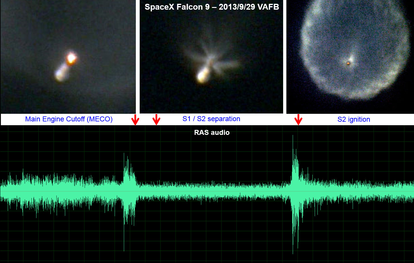
A ground based long range Remote Acoustic Sensor (RAS) telescope provided visual and aural views of the September 29, 2013 launch of a SpaceX Falcon 9 rocket. This example shows main engine cutoff, stage separation and second stage engine start high above the Earth.
Credit: Dan Slater
Yet another idea is a miniaturized version of the device that could find its way onto the surface of Mars or upon the frozen ice fields of Jupiter’s Europa – to eavesdrop for signs of life.
For details on this technology, go to my new Space.com story at:
Listening for Alien Life: Could New Tech Detect Microbe Movements? by Leonard David, Space.com’s Space Insider Columnist October 01, 2015 07:09am ET
http://www.space.com/30709-space-noise-sensor-alien-life.html

Color-coded topographic map of Occator crater on Ceres produced from Dawn spacecraft imagery.
Blue is the lowest elevation, and brown is the highest. The crater, which is home to the brightest spots on Ceres, is approximately 56 miles (90 kilometers wide).
Credit: NASA/JPL-Caltech/UCLA/MPS/DLR/IDA
Data gleaned by NASA’s Dawn spacecraft at Ceres has provided another type of look at the puzzling Occator crater.
NASA has released a color-coded topographic map of the bright spots found within the 56 miles (90 kilometers wide) crater.
The topographic images of Occator (oh-KAH-tor) show the brightest spots and a cone-shaped 6-mile-high (4-kilometer-high) mountain.

This view, made using images taken by NASA’s Dawn spacecraft, features a tall conical mountain on Ceres.
Elevations span a range of about 5 miles (8 kilometers) from the lowest places in this region to the highest terrains. Blue represents the lowest elevation, and brown is the highest. The white streaks seen running down the side of the mountain are especially bright parts of the surface.
Credit: NASA/JPL-Caltech/UCLA/MPS/DLR/IDA/PSI
Scientists are still trying to identify processes that could produce these and other unique “Cerean” phenomena.
Closer looks slated
The Dawn spacecraft is currently orbiting Ceres at an altitude of 915 miles (1,470 kilometers). At that height the spacecraft will image the entire surface of the dwarf planet up to six times in this phase of the mission.
Each imaging cycle takes 11 days.
Starting in October and continuing into December, Dawn will descend to its lowest and final orbit, an altitude of 230 miles (375 kilometers).
The spacecraft will continue imaging Ceres and taking other data at higher resolutions than ever before at this last orbit. It will remain operational at least through mid-2016.
Twofer targeting
Dawn is the first mission to reach a dwarf planet, and the first to orbit two distinct extraterrestrial targets: It arrived at Ceres on March 6, 2015 and carried out observations of Vesta in 2011 and 2012.
Dawn’s mission is managed by the Jet Propulsion Laboratory (JPL) for NASA’s Science Mission Directorate in Washington.
More information about Dawn is available at the following sites:
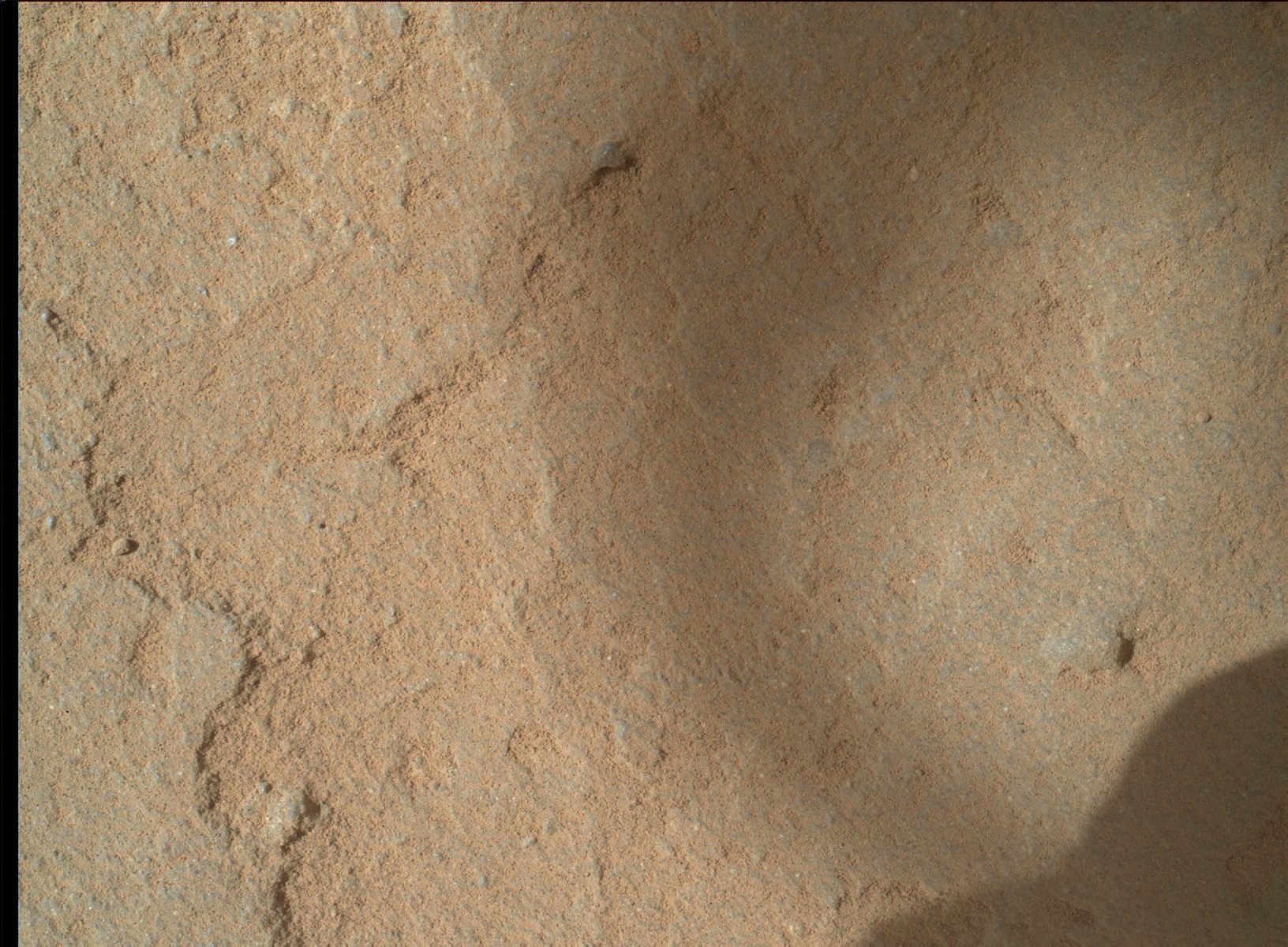
NASA’s Mars rover Curiosity Mars Hand Lens Imager (MAHLI), located on the turret at the end of the rover’s robotic arm, captured this image on September 26, 2015, Sol 1116.
Credit: NASA/JPL-Caltech/MSSS
Today is Sol 1119 for the Mars Curiosity rover mission.
Over last weekend, a mini-drill has cleared the way for drilling “Big Sky.”
“The hope is that this location will provide a good sample of the ‘typical’ rock in the area to compare with some of the interesting alteration we’ve been seeing,” reports Ryan Anderson, a planetary scientist at the USGS Astrogeology Science Center in Flagstaff, Arizona.

Roughly an hour later, this image was taken by Mars rover Curiosity’s Mars Hand Lens Imager (MAHLI).
Credit: NASA/JPL-Caltech/MSSS
Along with the drilling, there will be a number of Mars Hand Lens Imager (MAHLI) documentation images taken of the hole from varying distances and angles.
Anderson reports that on sol 1120, the rover’s Chemistry & Camera (ChemCam) will target the drill tailings, along with the targets “Devil’s Basin,” “Livingston,” and “Deadwood.”
Curiosity’s Mastcam is slated to document the drill hole and all of the ChemCam targets. Then, later in the day on sol 1120, Navcam and Mastcam both have some atmospheric observations.
The robot’s Dynamic Albedo of Neutrons (DAN), the Radiation Assessment Detector (RAD), and the Rover Environmental Monitoring Station (REMS) are scheduled to perform routine monitoring, Anderson adds.
Actual dates of planned rover activities are subject to change due to a variety of factors related to the Martian environment, communication relays and rover status.

RSL activity in the central peaks of Horowitz crater and associated CRISM spectra.
Credit: Lujendra Ojha, et al./Nature Geoscience
Mars researchers offered today the strongest proof yet that there is “intermittent flowing liquid water” present on the Red Planet.
That prospect bolsters the chance that Mars may well be an extraterrestrial address for life. Furthermore, it offers future human explorers sites to look for Martian life and might help expeditionary crews sustain their presence on the planet.

RSL emanating from a central peak in Hale crater.
Credit: Lujendra Ojha, et al./Nature Geoscience
The new evidence comes from work led by Lujendra Ojha of the Georgia Institute of Technology. A group of experts made use of instruments onboard NASA’s Mars Reconnaissance Orbiter (MRO): the High Resolution Imaging Science Experiment (HiRISE) and the Compact Reconnaissance Imaging Spectrometer for Mars (CRISM).
Focus of attention: RSL
The focus of attention for the orbiting gear was recurring slope lineae or RSL for Mars short-hand.
RSL form and snake down steep slopes on the planet during warm seasons when temperatures exceed -10 degrees Fahrenheit (-23 degrees Celsius). They disappear at colder times during the Martian year.
Measured were spectral signatures of hydrated minerals on slopes where the puzzling RSL are found on Mars.
Ojha reported today that spectral signatures of hydrated salts were visible in many RSL if they were relatively wide in diameter. The clincher came when the researchers looked at the same locations when RSL weren’t visible and the hydration signatures had disappeared.
Briny, rather than pure
“Something is hydrating these salts, and it appears to be these streaks that come and go with the seasons,” Ojha stated in a university press release.

Credit: Georgia Institute of Technology
“This means the water on Mars is briny, rather than pure. It makes sense because salts lower the freezing point of water. Even if RSL are slightly underground, where it’s even colder than the surface temperature, the salts would keep the water in a liquid form and allow it to creep down Martian slopes,” Ojha explains.
The researchers believe that the signatures are caused by previously discovered hydrated minerals called perchlorates. This new study, however, detected perchlorates in entirely different areas from where earlier landers explored. This is also the first time perchlorates have been identified from orbit.

NASA Mars Reconnaissance Orbiter’s HiRISE image of recurring slope lineae in Melas Chasma, Valles Marineris. Arrows point out tops and bottoms of a few lineae.
Credit: NASA/JPL-Caltech/University of Arizona
“This is the first spectral detection that unambiguously supports our liquid water-formation hypotheses for RSL,” Ojha adds.
Contemporary Mars
The Mars RSL team also includes researchers from NASA Ames Research Center, the Johns Hopkins University Applied Physics Laboratory, University of Arizona, Southwest Research Institute and Laboratoire de Planétologie et Géodynamique.
Their collective work appears in the paper, “Spectral evidence for hydrated salts in recurring slope lineae on Mars,” published in the journal Nature Geoscience.
“Determining whether liquid water exists on the Martian surface is central to understanding the hydrologic cycle and potential for extant life on Mars,” they write in the research paper.
“These results strongly support the hypothesis that seasonal warm slopes are forming liquid water on contemporary Mars. The spectral identification of perchlorate in association with RSL also suggests that the water is briny rather than pure,” the paper notes.

Credit: Georgia Institute of Technology
Additionally, the paper calls for “further astrobiological characterization and exploration of these unique regions on Mars.” However, the scientists do caution that while there are transiently wet conditions near surface on Mars, the water activity in perchlorate solutions “may be too low to support known terrestrial life.”
What next?
So given this new research, what next?
James Wray, Georgia Tech assistant professor and advisor to the university-led work, told Inside Outer Space:
“Personally, I think we could learn a lot about RSL from landing ‘near’ them…far enough away that they’re outside the landing uncertainty ellipse…and then driving close enough to image, but not to touch.”
Wray said that from orbit there’s no way to watch a given RSL evolve from one hour to the next, day after day, to determine when they are active.
“We could do this easily on the ground, even from a stationary lander,” Wray said. “Of course, eventually we will want to know more about their chemistry and organic content, if any, which would likely require contact science using a sterilized probe.”

RSL exploration zone. THEMIS daytime-IR mosaic with proposed human survey zone (blue circle) and features of interest.
Credit: A. McEwen, et al.
Human exploration sites
Next month, the “First Landing Site/Exploration Zone Workshop for Human Missions to the Surface of Mars” is being held at the Lunar and Planetary Institute in Houston, Texas.
One favorable zone advocated for human exploration is Eastern Melas Chasm. In work spearheaded by Alfred McEwen at the University of Arizona, that locale meets a number of criteria, including access to RSL.
Still to be determined, however, is whether or not RSL can produce useable water for human crews, McEwen and his colleagues explain. If Eastern Melas is considered a promising region for astronauts to inspect, then more CRISM and HIRISE coverage by MRO is warranted. A future orbiter could provide important new observations as well, they suggest.
Major priority
Similarly, Hale crater is being proposed, primarily because of the ease with which liquid water can be extracted from recurring slope lineae found on the slopes of its central peak complex.
According to lead author of that exploration zone paper, David Stillman of the Southwest Research Institute in Boulder, Colorado: “The search for extant life within RSL should be a major priority.”

Proposed Hale crater site for human exploration.
Credit: D.E. Stillman, et al.
Stillman notes that the RSL in Hale crater must be so briny – very low water activity values — that no known terrestrial life can respire there. This reduces the impact of cross-contamination by terrestrial life, he and colleagues suggest, therefore that reduces planetary protection worries.
“However, Martian life may have either evolved a way to live in such an environment, or may be living within the depths of the RSL source regions,” Stillman and his co-authors conclude.
For more information, go to:
Mineralogical Confirmation for Liquid Water on Present-day Mars
http://www.news.gatech.edu/2015/09/25/mineralogical-confirmation-liquid-water-present-day-mars
Also, go to the Nature Geoscience Letter:
“Spectral evidence for hydrated salts in recurring slope lineae on Mars”
http://www.nature.com/ngeo/journal/vaop/ncurrent/full/ngeo2546.html
2014 test run of E-MIST hardware.
Credit: NASA
UPDATE: “Sunday scrubbed. Looking towards Monday now – weather is the issue” – David Smith
The Exposing Microorganisms in the Stratosphere (E-MIST) 2015 Flight Mission has a good chance of a balloon liftoff on Sunday, September 27.
That payload will be onboard the Long-Duration Balloon (LDB) Test Flight II, departing Ft. Sumner, New Mexico.

E-MIST mounted to the balloon gondola on Sept. 13, 2015 at the Columbia Scientific Balloon Facility in Ft. Sumner, New Mexico. The big red arrow is pointing to E-MIST.
Credit: NASA
E-MIST 2015 is an experiment that will study the survival of spore-forming bacteria carried to 125,000 feet above the New Mexico desert on a high altitude NASA scientific balloon.
The payload will transport known quantities of Bacillus pumilus SAFR-032, a highly-resilient bacterial strain originally isolated from a spacecraft assembly facility, to the stratosphere for up to 24 hours.
E-MIST Principal Investigator, David J. Smith at NASA’s Ames Research Center told Inside Outer Space that things look good for Sunday, weather depending.
Mars-like conditions
Earth’s stratosphere mimics key surface conditions on Mars. The air is thin, cold, dry, and irradiated.
On the E-MIST science flight, researchers will monitor bacterial survival in the Mars analog environment to help NASA predict — and prevent — microbial contamination of the Red Planet by exploring spacecraft.

Pre-launch photo looks down on the E-MIST payload from the top of the balloon gondola at Ft. Sumner, New Mexico. Several instruments/sensors and four sample-holding canisters can be seen on the front face of the payload.
Credit: NASA
The E-MIST hardware system was developed at NASA’s Kennedy Space Center in Florida. The E-MIST hardware was successfully flight tested in 2014.
The upcoming sendoff into the stratosphere will mark the second flight of the E-MIST hardware — the first full science mission using the system — is from NASA’s Columbia Scientific Balloon Facility in Fort Sumner, New Mexico.
How to watch the flight online!
During the experiment, the public can watch the progress of the flight unfold by following the links to Fort Sumner Operations from NASA’s Columbia Scientific Balloon Facility website at:
http://towerfts.csbf.nasa.gov/
For video on the launch day: click “Near Real Time Video” under “Fort Sumner Operations.” Then click on “Fort Sumner UStream Video Feed.”
For real-time payload position information on the launch day: click “CSBF Test Flight II” listed under the section “Fall 2015 Flights Below.”

Electron micrograph of spores of the bacterium Bacillus pumilus on the E-MIST hardware.
Credit: NASA
Busy launch center
The balloon launching center has been busy!
On Friday, September 25, 2015, NASA’s Radiation Dosimetry Experiment, or RaD-X, was launched and landed today, ending its mission.
RaD-X is designed to provide first-time indications of how cosmic rays deposit energy at the top of atmosphere – an activity that produces showers of additional particles that increase the energy deposited where commercial airlines fly.
This experiment is crafted to improve NASA’s Nowcast of Atmospheric Ionizing Radiation for Aviation Safety (NAIRAS) model, which is currently used by public and private entities for informed decision-making about radiation exposure safety for flight crews, the general public, and commercial space operations.

Mars true-color globe showing Terra Meridiani.
Credits: NASA/Greg Shirah
NASA will detail a major science finding from the agency’s ongoing exploration of Mars during a news briefing at 11:30 a.m. EDT on Monday, Sept. 28 at the James Webb Auditorium at NASA Headquarters in Washington.
The event will be broadcast live on NASA Television and the agency’s website.
News conference participants will be:
— Jim Green, director of planetary science at NASA Headquarters
— Michael Meyer, lead scientist for the Mars Exploration Program at NASA Headquarters
— Lujendra Ojha of the Georgia Institute of Technology in Atlanta
— Mary Beth Wilhelm of NASA’s Ames Research Center in Moffett Field, California and the Georgia Institute of Technology
Resources
For NASA TV downlink information, schedules and to view the news briefing, visit:
The event will also be carried live on:

Credit: Foster + Partners/New York
The imaginative folks at Foster + Partners/New York noted today that they are amongst 30 finalists for the 3D Printed Habitat Challenge organized by America Makes and NASA.
This contest, previously reported by Inside Outer Space, is asking for ideas to develop a settlement on Mars constructed by an array of pre-programmed, semi-autonomous robots prior to the eventual arrival of Mars-landing crews.

Credit: Foster + Partners/New York
Foster + Partners/New York envisions a robust 3D-printed dwelling for up to four astronauts constructed using regolith – the loose soil and rocks found on the surface of Mars.

Credit: Foster + Partners/New York
Explains a Foster + Partners news release: “The compact 93 square meter habitat modules “combines spatial efficiency with human physiology and psychology, with overlapping private and communal spaces, finished with ‘soft’ materials and enhanced virtual environments, which help reduce the adverse effects of monotony, while creating positive living environment for the astronauts.”
Minimal human input
The proposal envisions the habitat delivered in two stages prior to the arrival of the astronauts.

Credit: Foster + Partners/New York
First, the semi-autonomous robots select the site and dig a 5 foot (1.5 meters) deep crater, followed by a second delivery of the inflatable modules which sit within the crater to form the core of the settlement.
“Given the vast distance from the Earth and the ensuing communication delays, the deployment and construction is designed to take place with minimal human input, relying on rules and objectives rather than closely defined instructions. This makes the system more adaptive to change and unexpected challenges – a strong possibility for a mission of this scale,” the design company statement explains.
“Diggers,” “Transporters,” and “Melters”
Three different kinds of robots are parachuted to the surface of Mars, each performing a specialized task within the large-scale Regolith Additive Construction process.

Credit: Foster + Partners/New York
The larger ‘Diggers’ create the crater by excavating the regolith, which the medium-sized ‘Transporters’ then move into position over the inflatable habitat modules layer by layer.
The loose Martian soil is then fused around the modules using microwaves – the same principles involved in 3D-printing – by several small ‘Melters’.

Credit: Foster + Partners/New York
The fused regolith creates a permanent shield that protects the settlement from excessive radiation and extreme outside temperatures.

Credit: Foster + Partners/New York
“The separation of tasks amongst the large number of robots, and the modularity of the habitat means a high level of redundancy is incorporated within the system – if one robot fails, or a single module is damaged, there are others that can fulfill its task, increasing the chances of a successful mission,” the designers conclude.

