Author Archive

The Earth straddling the limb of the Moon, as seen from above Compton crater. Center of the Earth in this view is 4.04°N, 12.44°W, just off the coast of Liberia. The large tan area in the upper right is the Sahara desert, and just beyond is Saudia Arabia. The Atlantic and Pacific coasts of South America are visible to the left.
Credit: NASA/GSFC/Arizona State University
NASA’s Lunar Reconnaissance Orbiter circling Earth’s Moon has been used to produce a gorgeous image of our home planet.
Using the spacecraft’s Lunar Reconnaissance Orbiter Camera (LROC), imagery provides an interesting perspective of both Earthrises and Earthsets — something someone standing on the Moon wouldn’t be able to.
LROC is operated by Arizona State University (ASU).
No simple selfie
According to an ASU press statement, the images from the Moon of Earth are no simple space selfie.
The maneuver of LRO involved the spacecraft rolling 67 degrees to the side and then slewing with the direction of travel to maximize the width of the horizon — while traveling faster than 3,580 miles per hour.

NASA’s Lunar Reconnaissance Orbiter (LRO) now circling the Moon.
Credit: NASA/GSFC
Hardly static
Mark Robinson, a professor in ASU’s School of Earth and Space Exploration is the principal investigator for the LROC.
The Earth may not move across the lunar sky, Robinson says, but the view is hardly static.
“Future astronauts will see continents rotate in and out of view, and the ever-changing pattern of clouds will always catch one’s eye — at least for those on the lunar side that faces Earth,” Robinson said.
NOTE: Find more images and technical explanations on the LROC website at:

Courtesy: CubeSat for Disclosure
It is a growth industry…the popularity and proliferation of CubeSats. They carry out all manner of duties, from testing laser communications hardware to imaging the Earth.
Now add one more task for a CubeSat – keeping an eye out for visiting ET.
The effort is called “CubeSat for Disclosure” and a fundraising campaign in underway to build the low Earth orbiting satellite. The campaign is via Indiegogo, the website that “empowers people to activate the global community to make ideas happen.”
Empowering individuals
According to the proposal team, the project aims to use a low orbit satellite, controlled by individuals, to study potential objects that emit high energy radiation.
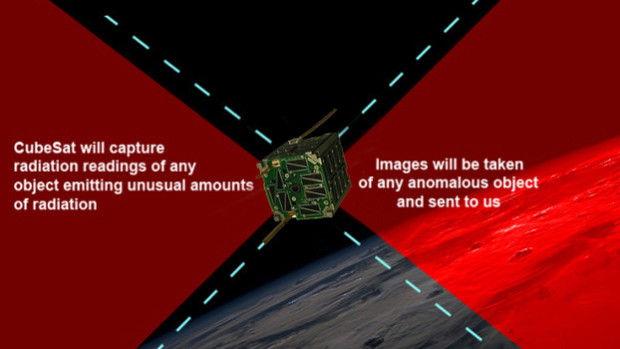
Credit: CubeSat for Disclosure
“Maybe we’ll get data readings and pictures of solar-flare caused auroras. Maybe we’ll capture images of some very interesting meteors. And maybe we’ll actually capture a verifiable craft. All we can do is try, and by doing this our way, we can open-source the data to you, the individuals,” the project site notes.
Satellite instruments
The CubeSat for Disclosure would be capable of measuring the radiation in the environment of the satellite, equipped to detect high energy particles, radiation, and other phenomenon. Two cameras with parabolic lenses would provide a clear 360 degree view around our satellite.
The team leaders would like to have the CubeSat carry a mini-radar, if possible. “Regardless of radar, our radiation detection and imagery will give us enough to verify high energy emitting objects in space.”
Credit: UFODATA Project
Real-time data collection
Saluting the CubeSat for Disclosure initiative is Mark Rodeghier, President and Scientific Director of the J. Allen Hynek Center for UFO Studies in Chicago, Illinois. He’s also a leader in the UFODATA Project, detailed here:
What are UFOs? New Scientific Study Launched
https://www.leonarddavid.com/what-are-ufos-new-scientific-study-launched/
“I only know what they’ve put on their fundraising website, but overall, I personally, as does the UFODATA project, support any serious effort at identifying and then measuring physical data about UFOS in real-time,” Rodeghier told Inside Outer Space.
“Science normally benefits from multiple approaches to the same problem, as there is no guarantee which research method will be the most successful, and the same is true for research into UFOs,” Rodeghier said. “Whether UFOs appear often enough in space to make such an effort practical is unknown, but we won’t know until someone looks.”
NOTE: For more information on the CubeSat for Disclosure campaign, go to:
https://www.indiegogo.com/projects/cubesat-for-disclosure-low-earth-orbit-satellite#/updates
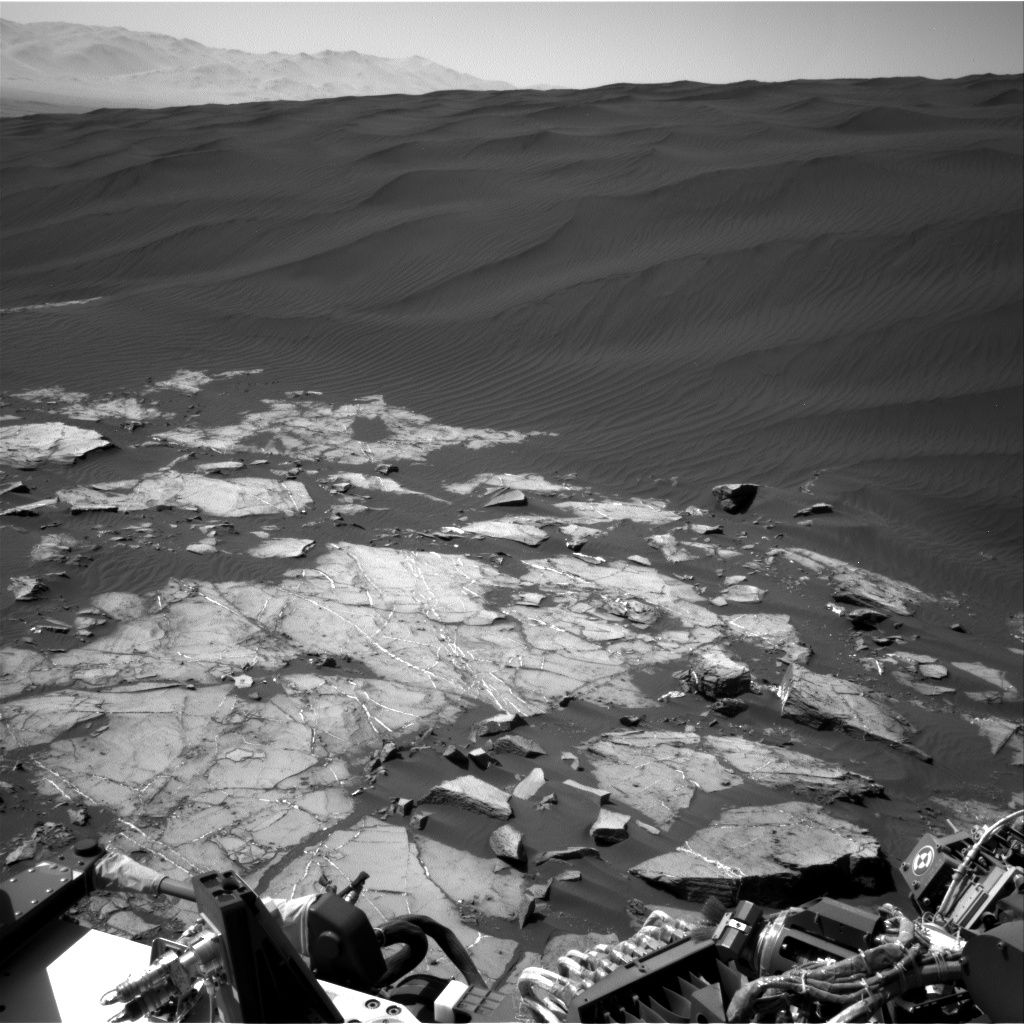
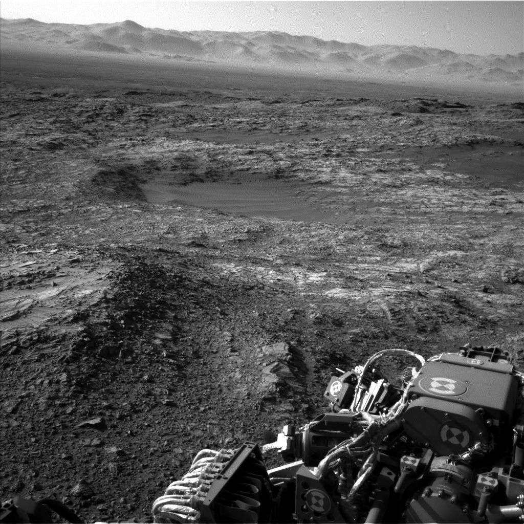
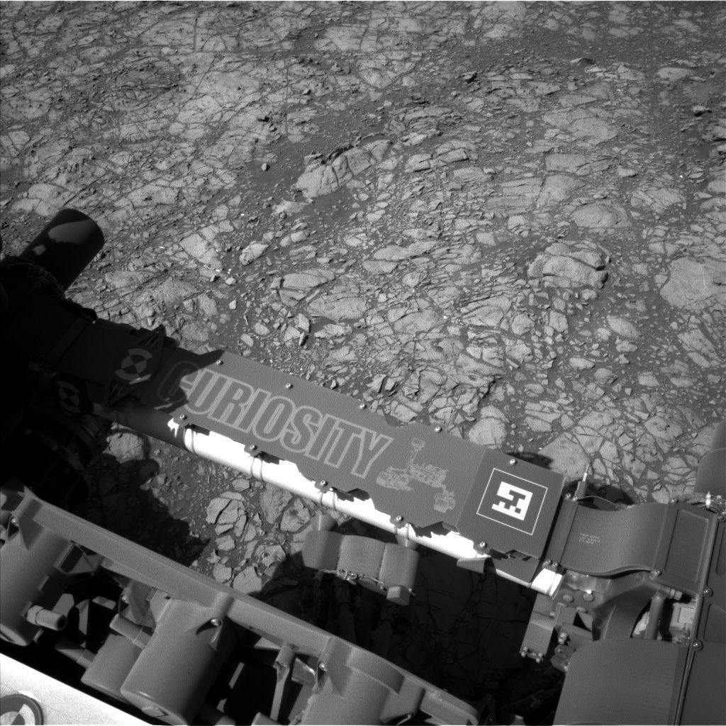
Curiosity Mastcam Left Sol 1194 on December 16, 2015.
Credit: NASA/JPL-Caltech/MSSS
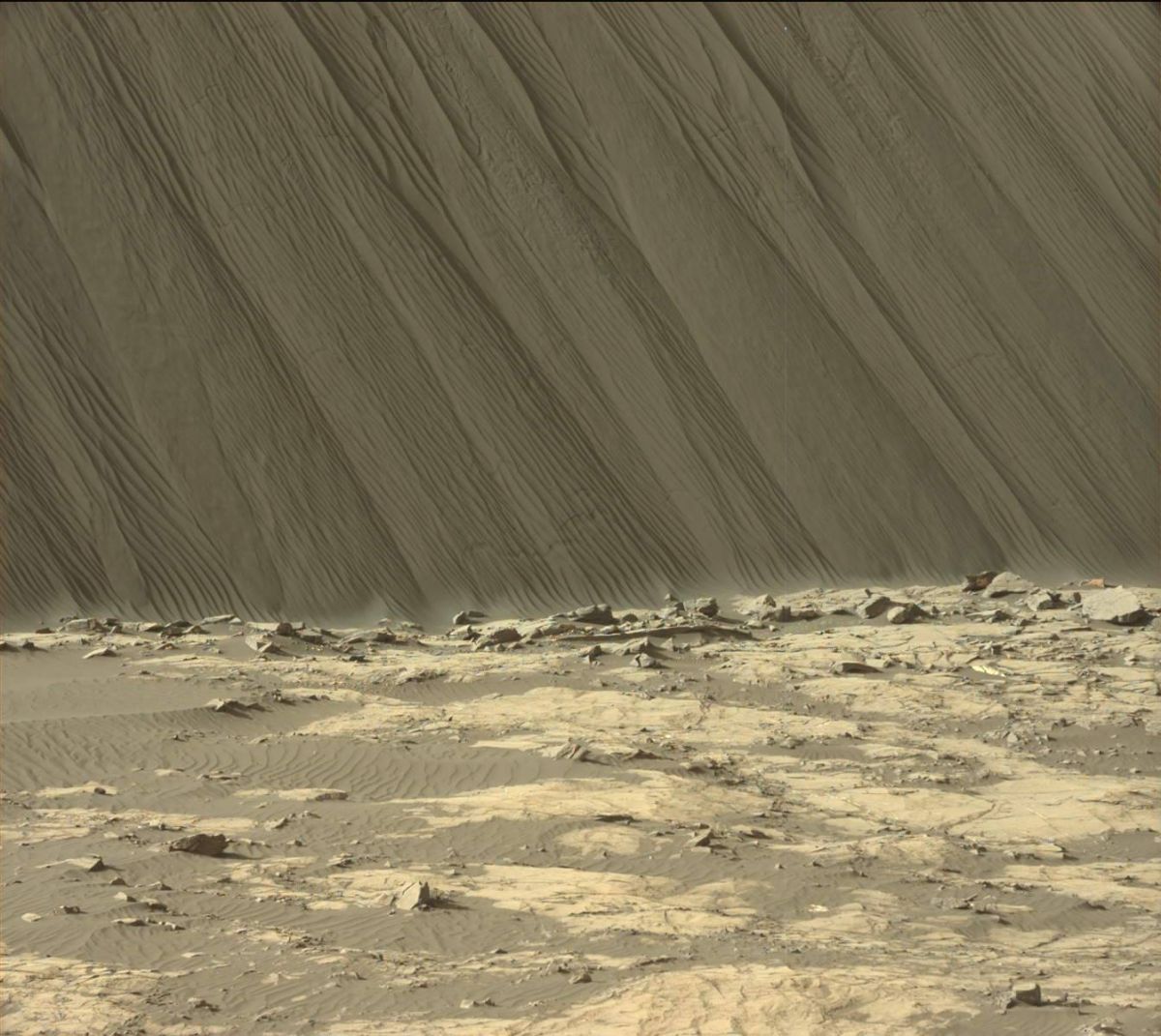
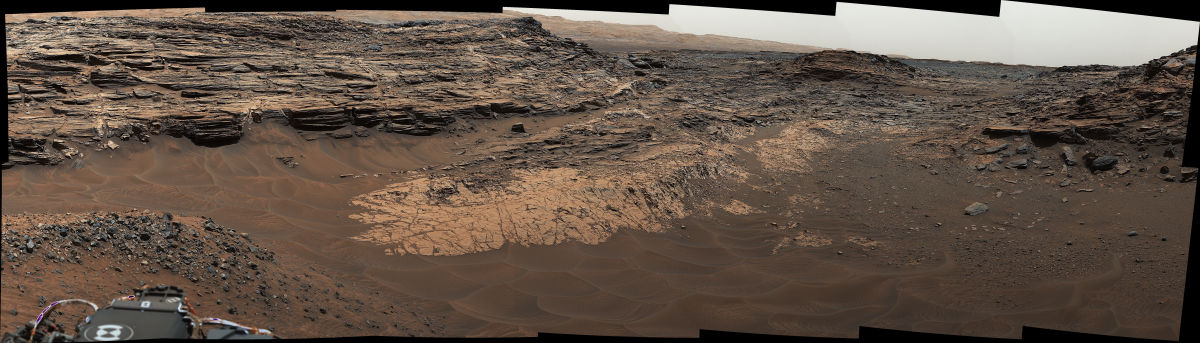
Curiosity on Mars has entered Sol 1196 recently driving nearly 155 feet (47 meters) around the lee side of Namib Dune.
“The latest Navcam images reveal many beautiful aeolian features on the slipface and interdune deposits,” reports Lauren Edgar, a research geologist at the USGS Astrogeology Science Center and a member of Mars Science Laboratory science team.
The plan call for Mastcam imagery to be taken of the brink of the dune and its slipface to characterize the dune morphology, Edgar adds. “We’ll also use Mastcam to document an outcrop with an unusual purple hue.”
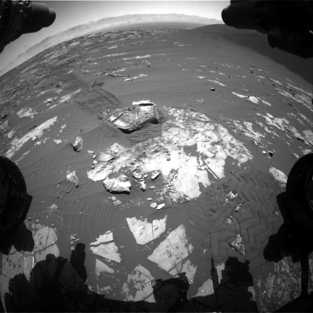
Curiosity Front Hazcam Right B Sol 1195, December 16, 2015.
Credit: NASA/JPL-Caltech
Also slated is driving the rover even closer to the dune slipface, taking post-drive pictures to prepare for the upcoming weekend of rover duties. A 360-degree Mastcam mosaic for geologic context is in the plan, as is monitoring the wind as Curiosity moves through the dune field.
Rover scientists are having a challenge staging all of the observations into a plan while staying within data volume constraints.
Edgar notes: “It’s hard to curb your imaging appetite when the views are so spectacular!”
As always, carrying out planned rover activities are subject to change due to a variety of factors.
NOTE: For more on Curiosity’s investigation of Martian dunes, go to this new video published on December 15, 2015.
The video spotlights Curiosity’s first investigation of active sand dunes on another planet. Studying the Bagnold Dunes on Mars will help scientists understand the physics of Martian dunes and how they move.
https://www.youtube.com/watch?v=ur_TeOs3S64&feature=youtu.be
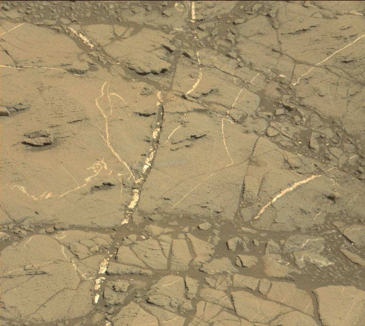
This May 22, 2015, view from the Mast Camera (Mastcam) in NASA’s Curiosity Mars rover shows the “Marias Pass” area where a lower and older geological unit of mudstone — the pale zone in the center of the image — lies in contact with an overlying geological unit of sandstone.
Credit: NASA/JPL-Caltech/MSSS
This image was taken by Curiosity’s Navcam Left B camera on Sol 1194, December 16, 2015.
Credit: NASA/JPL-Caltech
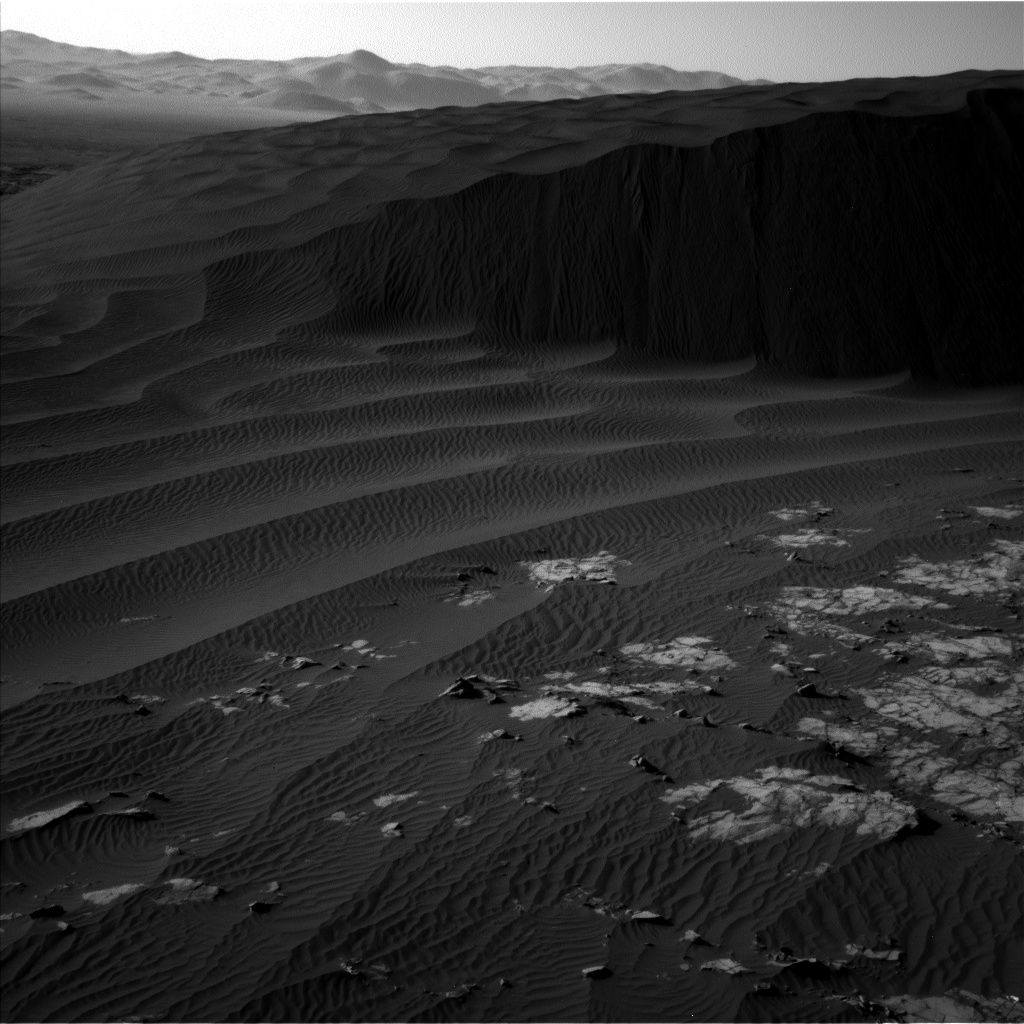
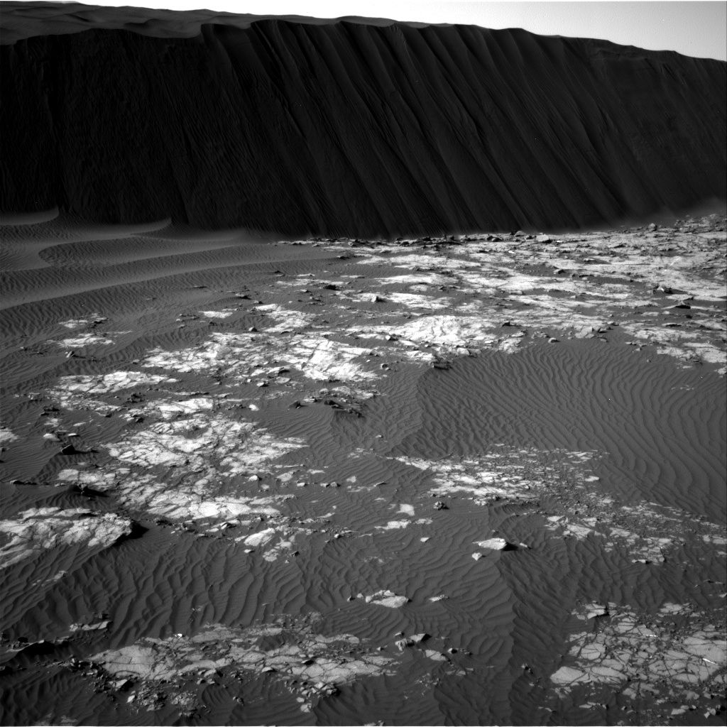
NASA’s Curiosity rover on Mars has taken a number of new images of Martian sand dunes.
The robot continues to drive around Namib Dune, relaying impressive photos of the feature, including up close looks at local bedrock.
Curiosity is now on duty, entering Sol 1195 since its landing in August 2012.
Curiosity’s Navcam Right B snapped this image on Sol 1194, December 16, 2015.
Credit: NASA/JPL-Caltech
Images taken by the Mars machinery are providing scientists with a better understanding of the morphology of the ripples and grain flows of Namib Dune.
To view a high resolution map of the rover’s whereabouts, go to:
http://mars.jpl.nasa.gov/msl/imgs/2015/12/Curiosity_Location_Sol1187-full.jpg
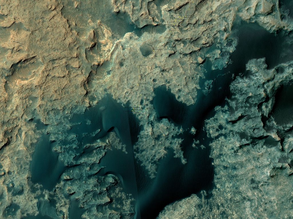
This map shows the route driven by NASA’s Mars rover Curiosity through the 1187 Martian day, or sol, of the rover’s mission on Mars – as of December, 09, 2015.
Numbering of the dots along the line indicate the sol number of each drive. North is up.
From Sol 1185 to Sol 1187, Curiosity had driven a straight line distance of about 92.61 feet (28.23 meters).
The base image from the map is from the High Resolution Imaging Science Experiment Camera (HiRISE) in NASA’s Mars Reconnaissance Orbiter.
Credit: NASA/JPL-Caltech/Univ. of Arizona

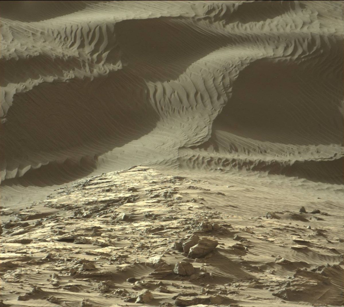
Curiosity view of Namib Dune, taken by rover’s Mastcam Right camera on Sol 1190, December 11, 2015.
Credit: NASA/JPL-Caltech/MSSS
Mars scientists continue to be delighted with imagery from the Curiosity rover of sand dunes, “and the view is pretty spectacular,” explains Lauren Edgar of the USGS Astrogeology Science Center in Flagstaff, Arizona.
Last weekend, the Mars machinery drove nearly 140 feet (42 meters) closer to “Namib Dune,” Edgar reports. We’ve received a lot of beautiful Mastcam and Navcam images.”
The plan calls for Curiosity to continue its drive around Namib Dune to get to the lee side.
Curiosity recently acquired ChemCam and Mastcam observations of targets named “Karfenkliff” and “Grillental” to characterize some of the local bedrock and veins, Edgar adds.
Curiosity Navcam Right B Sol 1192 December 13, 2015
Credit: NASA/JPL-Caltech
Ripples and grain flows
Also on the schedule is obtaining a Mastcam stereo mosaic of Namib Dune “to better understand the morphology of the ripples and grain flows,” Edgar explains. The plan also includes a Mastcam image of the rover deck to monitor the movement of particles.
The plan is scripted to drive the rover for roughly 155 feet (47 meters) and take post-drive imaging to document the local geology and prepare for targeting in Wednesday’s duties.
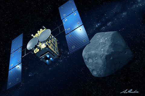
Japan’s Hayabusa2 en route to asteroid Ryugu.
Credit: JAXA/Courtesy of Akihiro Ikeshita
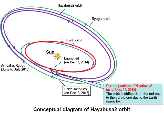
Following its Earth swing-by, a spacecraft is now on trajectory and headed for asteroid “Ryugu.”
Japan’s Hayabusa2 is en route to its target, a C-type asteroid to study the origin and evolution of the solar system as well as materials for life.
The Japan Aerospace Exploration Agency (JAXA) announced today that the swing-by of Earth on December 3, the explorer’s orbit turned by about 80 degrees and the probe’s speed was increased.
Credit: JAXA
In good health
According to the operation supported by the NASA Deep Space Network stations and European Space Agency deep space ground station, “the Hayabusa2 is in good health,” JAXA reports.
JAXA adds that as of 0:00 a.m. on Dec. 14, 2015, the Hayabusa2 is flying at about 4.15 million kilometers from the Earth, and about 144.85 million kilometers from the Sun. Its cruising speed is 32.31 km per second (against the Sun). The Hayabusa2 is increasing its speed under the influence of the Sun’s gravity after the swing-by.

Australian continent and Antarctica captured by Hayabusa2 camera.
Credit: JAXA
Precious picture
Post swing-by, the Hayabusa2 took images of the Earth using its onboard Optical Navigation Camera — Telescopic (ONC-T).
One image released shows the Australian continent and Antarctica. The South Pole is not lit by the Sun during the summer, and meteorological satellites also do not cover the Antarctic area to take its images, “hence the shot this time is precious,” JAXA points out.
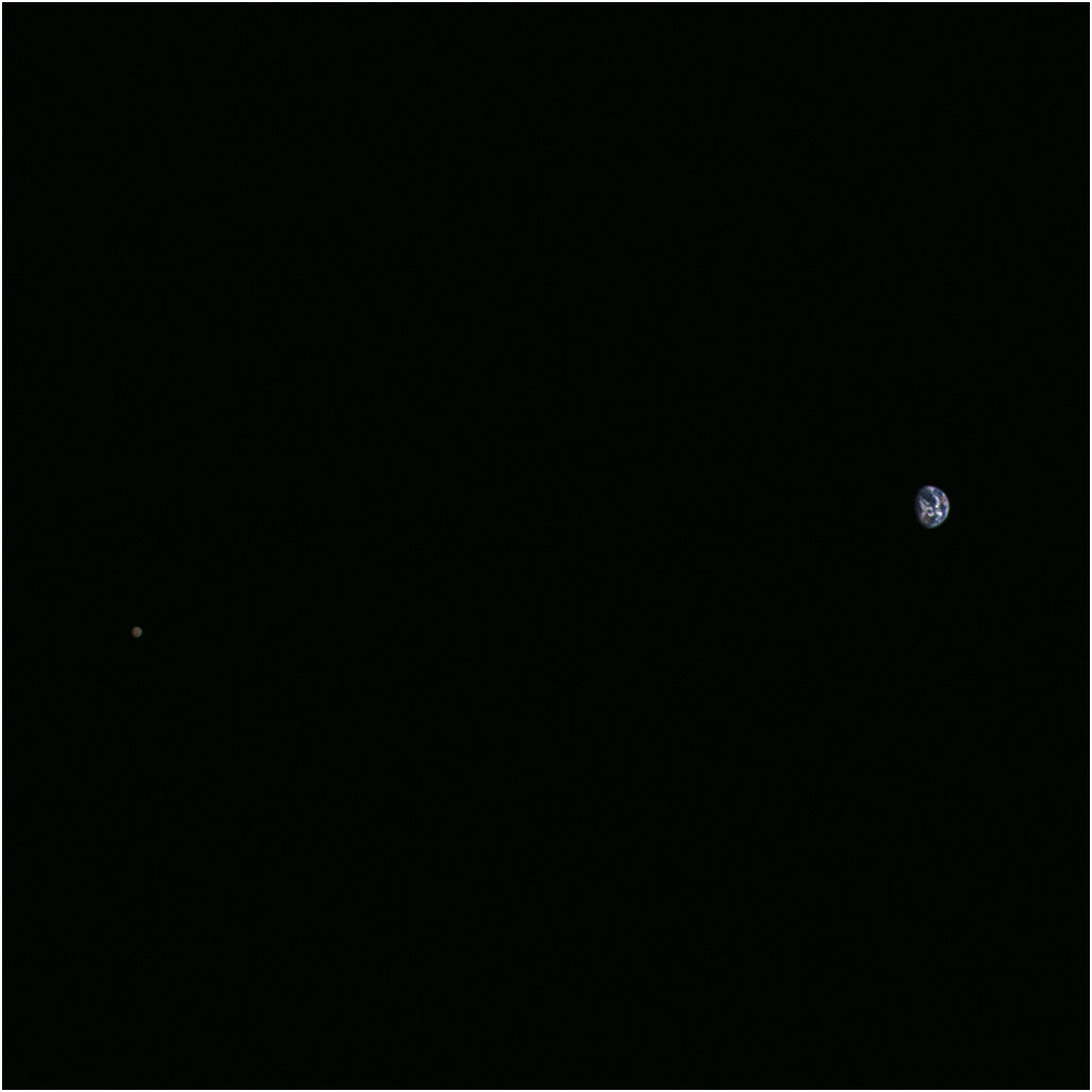
Celestial twosome: Moon and Earth taken by Hayabusa2.
Credit: JAXA
2020 return to Earth
Prior to the Earth swing-by, Hayabusa2’s ONC-T imaged the Earth and the Moon on November 26, 2015.
Hayabusa2 was launched on December 3, 2014. It should arrive at the C-type asteroid in mid 2018, carrying out an aggressive set of science and technology tasks for one and a half years, such as creating a crater on the object and sampling the space rock.
The craft will then depart the asteroid at the end of 2019 and return its sampling to Earth around the end of 2020.
Curiosity Navcam Left B image taken on Sol 1187, December 8, 2015.
Credit: NASA/JPL-Caltech
NASA’s Curiosity rover is relaying stunning images of Martian dunes.
The robot has entered Sol 1192 and has wheeled into position to inspect active dunes on the Red Planet.
Curiosity’s up-close investigations of dark sand dunes find them up to two stories tall. The dunes are in view as the rover continues to trek up the lower portion of a layered Martian mountain.
Curiosity Mastcam Right image taken on Sol 1190, December 11, 2015.
Credit: NASA/JPL-Caltech/MSSS
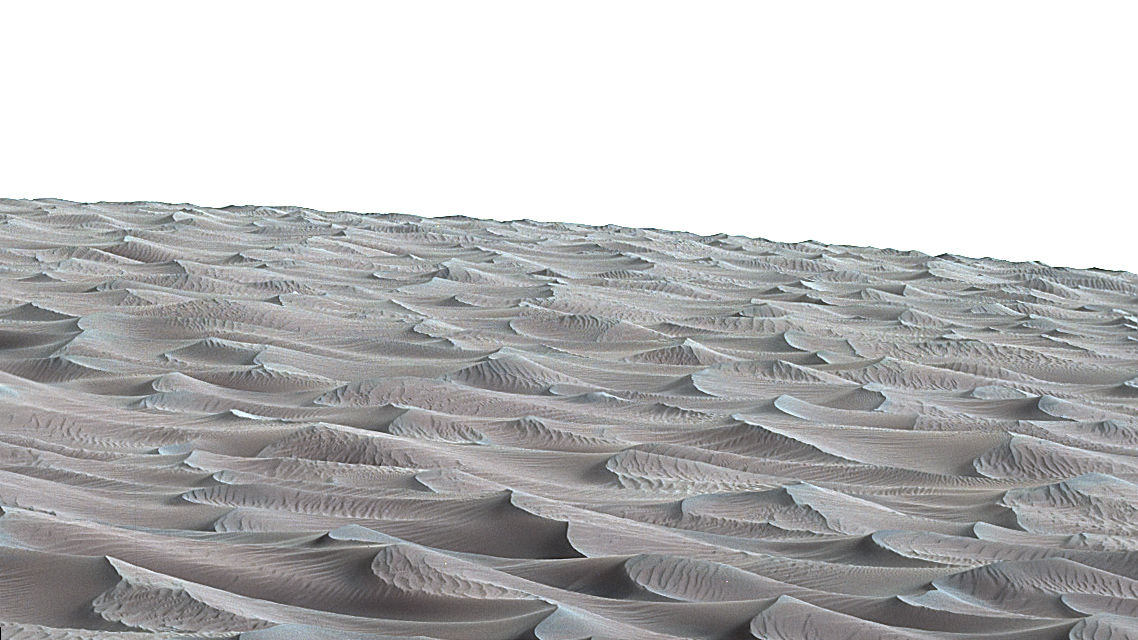
Observations from above Curiosity by the NASA Mars Reconnaissance Orbiter show the “Bagnold Dunes” near Curiosity and reveal that individual dunes move as much as 3 feet (1 meter) per Earth year.
Curiosity’s Mastcam Right images of dunes were taken on Sol 1190 December 11, 2015.
Curiosity’s Mastcam Right image taken on Sol 1190 December 11, 2015.
Credit: NASA/JPL-Caltech/MSSS

Curiosity’s Mastcam Right image taken on Sol 1190 December 11, 2015.
Credit: NASA/JPL-Caltech/MSSS
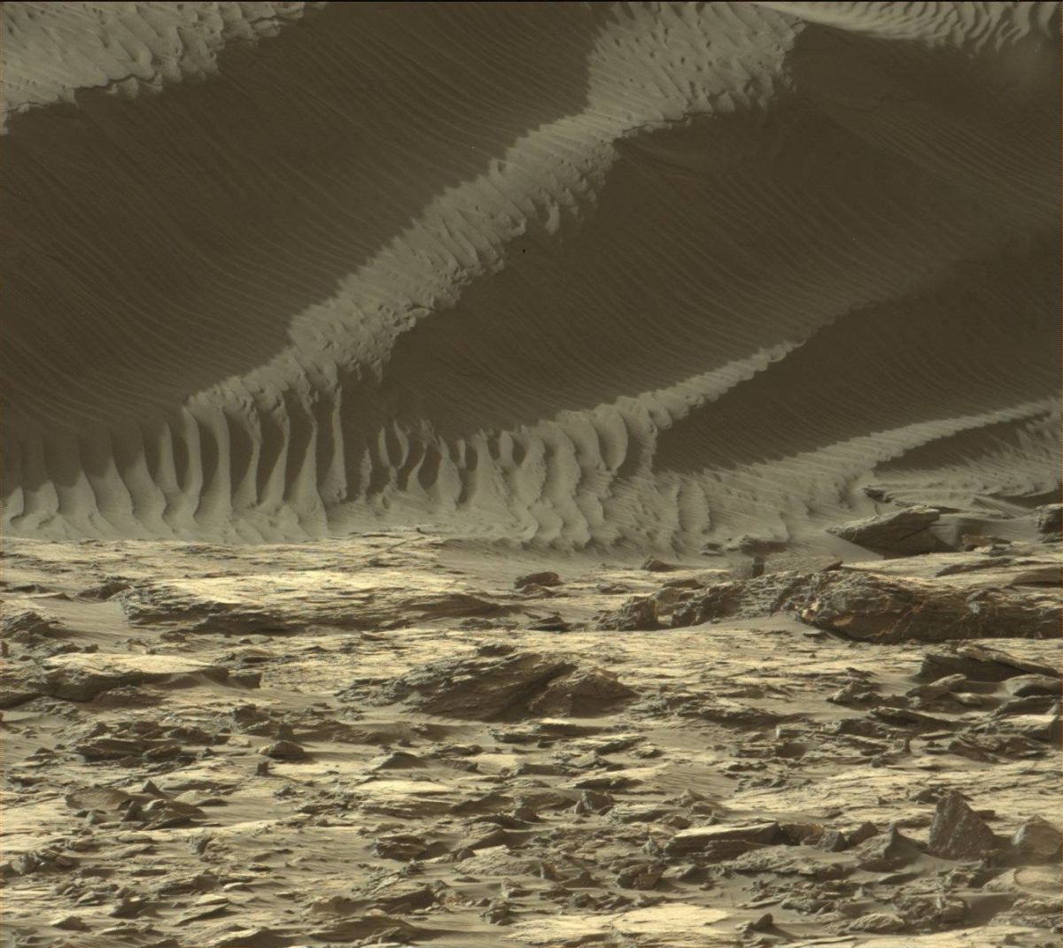
The rippled surface of the first Martian sand dune ever studied up close fills this Nov. 27, 2015 view of “High Dune” from the Mast Camera on NASA’s Curiosity rover. This site is part of the “Bagnold Dunes” field of active dark dunes along the northwestern flank of Mount Sharp.
Credit: NASA/JPL-Caltech/MSSS
The dune-inspecting Curiosity Mars rover is on a roll this weekend.
Scientists have scripted a weekend plan, making use of the robot’s tools to observe and study outcrop targets.
Curiosity has entered Sol 1191 with researchers planning to use the Mars Hand Lens Imager (MAHLI) to acquire images of “Elizabeth Ray” and “Pomona.”
According to Ken Herkenhoff of the USGS Astrogeology Science Center in Flagstaff, Arizona, Curiosity’s three-sol weekend plan is jam-packed with science duties.
As is always the case, carrying out planned rover activities are subject to change due to a variety of factors related to the Martian environment, communication relays and rover status.
Navcam Left B image taken on Sol 1189, December 10, 2015.
Image Credit: NASA/JPL-Caltech
Morning clouds and dust devils
On tap is use of the Alpha Particle X-Ray Spectrometer (APXS) to be placed on Pomona. The rover’s Chemistry & Camera (ChemCam) and Mastcam are set to observe bedrock targets “Messum” and “Karoo,” Herkenhoff explains.
Early on Sol 1192, Mastcam will acquire another stereo mosaic of the Namib dune, Herkenhoff reports, taking advantage of morning light, and a single image of a ridge named “Paresis.”
Later that sol, the rover is slated to drive toward the southwest and acquire post-drive data. On Sol 1193, ChemCam will acquire calibration data and Navcam will search for clouds. Lastly, early on Sol 1194, the rover’s Navcam and Mastcam will search for morning clouds and dust devils, and measure the amount of dust in the atmosphere by imaging the Sun, Herkenhoff adds.
Dunes on the move
The Jet Propulsion Laboratory (JPL) Curiosity website has noted that Curiosity is using its wheels, as well as its science payload, to investigate sand that forms active dunes on Mars.
Curiosity has started up-close investigations of dark sand dunes up to two stories tall. The dunes are on the rover’s trek up the lower portion of a layered Martian mountain.
Observations from orbit of the “Bagnold Dunes” near Curiosity’s current exploration zone show that edges of individual dunes move as much as 3 feet (1 meter) per Earth year.
This image was taken by Curiosity’s Mastcam: Right camera on December 10, 2015, Sol 1189.
Credit: NASA/JPL-Caltech/MSSS
Curiosity has been exploring Mars since its landing in early August 2012.
The robot reached the base of Mount Sharp in 2014.
The main mission objective now is to examine successively higher layers of Mount Sharp.

The hit movie The Martian is receiving kudos from all over the world – including thumbs up reviews from viewers when the film recently premiered in China.
In a new posting, Apollo 11 moonwalker, Buzz Aldrin, lifts his space helmet visor and takes a clear look at The Martian – pros and cons. He also reflects on how the film truly plays in terms of the reality when the humans to Mars mission will start to unfold.
Writers on Writers
The review appears in Variety – the daily review of show business and entertainment. Aldrin contributes to “Contenders: Writers on Writers – #14.”

Credit: Variety/Fox
To take a read, go to:
http://variety.com/gallery/contenders-writers-on-writers-2/#!14/the-martian/

Destination Mars – Monkeys before astronauts?
Credit: NASA/USGS
The word from Russia is that the country wants to send monkeys to the Red Planet by 2017. But waving the red flag on such a plan: People for the Ethical Treatment of Animals (PETA).
A few months ago, it was reported that researchers from the Russian Academy of Science are busy training four macaque monkeys to make a long-distance trek to the Red Planet.
Researcher Inessa Kozlovskaya is the leader of the team responsible for teaching the monkeys at the Institute of Biomedical Problems of the Russian Academy of Sciences. Educating the animals includes joystick training and tapping into the cognitive thinking and learning skills of the animals.
While the sojourn to Mars of the monkeys would take six-months, it wasn’t immediately clear whether there’s any provision to return the animals back to Earth.
Misguided mission
“PETA has written to Igor Komarov, the head of the Russian Federal Space Agency, calling on him to cancel the misguided mission and instead use high-tech 21st-century space exploration methods,” said Harriet Barclay, European Outreach Liaison of the PETA Foundation.
Barclay told Inside Outer Space that PETA was shocked to hear that Russia is planning to send four macaque monkeys to Mars in 2017.

Soviet Union’s Sputnik 2 carried the dog, Laika, into Earth orbit in 1957.
Courtesy: NASA
“There’s no reason to repeat the dark days of early space exploration, in which dogs and primates died in horrific ways, all alone in a tiny shuttle hurtling through space,” Barclay said. “Laika, the husky-mix dog who was sent into space on [the former Soviet Union’s] Sputnik 2 in 1957, died of overheating and panic within hours of take-off. Others animals sent into space have died of suffocation, frozen to death or burned up on impact,” she adds.
Robotics rather than animals
Barclay explains that primates are sensitive, intelligent animals and are likely to experience extreme distress during the years of tests and training in the run-up to the monkeys-to-Mars mission. Because the animals would be “unable to understand what is happening to them, they would be terrified if they’re eventually sent on a fatal mission that they never signed up for,” Barclay says.

U.S. Mercury program’s Ham, the first chimpanzee ever to ride into space in January 1961 is shown off by his animal trainer at Cape Canaveral, Florida.
Credit: NASA/KSC
In the PETA letter to Komarov, the organization explains that primates are no longer sent into space by American or European space agencies and that China’s space agency is focusing on high-tech robotics rather than animals.
“We will also be organizing eye-catching demonstrations at Russian embassies across Europe and urging our supporters all over the globe to join us in sending the message that animals are not astronauts,” Barclay concludes.

