Archive for October, 2020

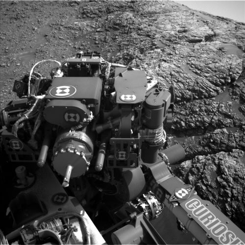
Contact science at “Garth Ness” (to right of Curiosity license plate). Curiosity Left B Navigation Camera image taken on Sol 2927, October 30, 2020.
Credit: NASA/JPL-Caltech
NASA’s Curiosity Mars rover is now performing Sol 2928 tasks.
This weekend, Curiosity continues working toward the sulfate unit of Mt. Sharp while conducting science along the way, reports Scott Guzewich, an atmospheric scientist at NASA’s Goddard Space Flight Center in Greenbelt, Maryland.

Curiosity Mast Camera Left image taken on Sol 2926, October 29, 2020.
Credit: NASA/JPL-Caltech/MSSS
The plan calls for contact science at “Garth Ness” with the Mars Hand Lens Imager (MAHLI) and the Alpha Particle X-Ray Spectrometer (APXS).

Curiosity Mast Camera Right photo acquired on Sol 2926, October 29, 2020.
Credit: NASA/JPL-Caltech/MSSS
Weekend science
The rover’s Chemistry and Camera (ChemCam), Guzewich notes, will continue the “ness-essary” weekend science with Laser Induced Breakdown Spectroscopy (LIBS) targets on “Fugla Ness,” “Stennes,” “Dunrossness,” and “Noness.”
Guzewich adds that a routine weekend involves weekly morning meteorological observations and searches for dust devils.

Credit: NASA/JPL-Caltech/Univ. of Arizona
“We’re in a time of year where dust devils are particularly frequent, and we want to watch for them as we approach the large sand sheet that Curiosity will be studying later up close to see if dust devils are moving sand around. We’ll then drive onward toward our next stop,” Guzewich explains.
New road map
Meanwhile, a new Curiosity traverse map through Sol 2923 has been issued.
The map shows the route driven by NASA’s Mars rover Curiosity through the 2923 Martian day, or sol, of the rover’s mission on Mars (October 26, 2020).
Numbering of the dots along the line indicate the sol number of each drive. North is up. The scale bar is 1 kilometer (~0.62 mile).
From Sol 2904 to Sol 2923, Curiosity had driven a straight line distance of about 171.85 feet (52.38 meters), bringing the rover’s total odometry for the mission to 14.37 miles (23.13 kilometers).
The base image from the map is from the High Resolution Imaging Science Experiment Camera (HiRISE) in NASA’s Mars Reconnaissance Orbiter.

Curiosity Mast Camera Right photo acquired on Sol 2926, October 29, 2020.
Credit: NASA/JPL-Caltech/MSSS

Credit: NASA/GSFC/LROC, School of Earth and Space Exploration, Arizona State University
The Lunar Reconnaissance Orbiter Camera’s (LROC) Lunar QuickMap has received a hefty fall 2020 update, including new interactive features and data layers that allow for even greater user customizations, on-the-fly data analysis, and lunar exploration.
For those unfamiliar with the Lunar QuickMap, it’s a highly interactive, web-based Geographic Information System (GIS) tool that hosts a tremendous pool of data from the Lunar Reconnaissance Orbiter Camera (LROC) and several other prominent instruments that have gathered, or continue to gather, data about the Moon.
Lunar QuickMap Credits: NASA/GSFC/LROC, School of Earth and Space Exploration, Arizona State University.
For more information, go to:

Curiosity Mars Hand Lens Imager photos produced on Sol 2926, October 29, 2020.
Credit: NASA/JPL-Caltech/MSSS
NASA’s Curiosity Mars rover is now performing Sol 2927 tasks.
The rover is busily studying a rock formation called “Hedgehope Hill” reports Catherine O’Connell-Cooper, a planetary geologist at the University of New Brunswick; Fredericton, New Brunswick, Canada.

“Hedgehope Hill” is visible on the upper left of this image taken Curiosity’s Mast Camera on Sol 2924, October 27.
Credit: NASA/JPL-Caltech/MSSS
“Sometimes in geology, as in life, it helps to look at the same thing from different perspectives,” O’Connell-Cooper says. Accordingly, a new plan calls for the robot to get very close to “Maybole” – the first of a series of resistant elongated rock features that are called “benches” in this area, and then pulling way back and looking again.

Curiosity Front Hazard Avoidance Left B Camera image taken on Sol 2926, October 29, 2020.
Credit: NASA/JPL-Caltech
Sequence of images
A newly scripted rover plan has the Mars Hand Lens Imager (MAHLI) acquiring a series of 15 images, focused on “Hedgehope Hill”
This sequence of images — known affectionately as a “MAHLI Dog’s Eye” — O’Connell-Cooper adds, will allow the compilation of a mosaic 40-centimeter long, at a standoff (distance from the rock surface) of 15-20 centimeters, which will yield a wealth of detailed information.

Curiosity Left B Navigation Camera photo taken on Sol 2926, October 29, 2020.
Credit: NASA/JPL-Caltech
“Using the mosaic, sedimentologists can determine details about everything from grain sizes and shapes to small scale sedimentary structures in this laminated rock,” O’Connell-Cooper notes.

Curiosity Left B Navigation Camera photo taken on Sol 2926, October 29, 2020.
Credit: NASA/JPL-Caltech
Drive to new location
Then, once the rover finishes up other objectives, it is slated to drive around 130 feet (40 meters) to a new location for the weekend, where Mastcam will image Maybole and the area to its east.

Curiosity Left B Navigation Camera photo taken on Sol 2926, October 29, 2020.
Credit: NASA/JPL-Caltech

Curiosity Left B Navigation Camera photo taken on Sol 2926, October 29, 2020.
Credit: NASA/JPL-Caltech
“Combining both the very detailed mosaic and the longer distance imagery will help us to understand the stratigraphy and to hopefully gain valuable insights into the evolution of these resistant bench features,” O’Connell-Cooper explains.
That mosaic will take a full hour to acquire, and Mars researchers had to practice restraint for the rest of the plan.
Survey the workspace
Other planned duties are active Chemistry and Camera (ChemCam) Laser Induced Breakdown Spectroscopy (LIBS) analysis on two targets: “Tingwall” towards the top of the Maybole ledge and “Ting” towards the bottom.
The robot’s Mastcam will take further images of the Maybole outcrop, including documentation of the ChemCam targets.
Also on tap is taking standard Navcam dust devil movies and document the dust in the atmosphere, via a Mastcam tau (opacity) measurement.
“At our new location for the weekend, Mastcam and Navcam will survey the workspace, getting post-drive workspace imagery to facilitate science observations in the weekend plan,” O’Connell-Cooper concludes.

Credit: Virgin Galactic
Virgin Galactic has introduced two new pilots into its “Pilot Corps” as the company moves ahead on commercial suborbital flight services from Spaceport America, New Mexico.
Jameel Janjua and Patrick Moran are joining the team, bringing the total number of rocket ship pilots to eight.
Both will embark on an extensive training program before flying SpaceShipTwo.

White Knight carrier craft carries SpaceShipTwo aloft for high-altitude release. Commercial suborbital flight operations are expected soon.
Credit: Virgin Galactic
Pilot qualifications, assignments
According to a posting from Virgin, in addition to the spaceship, the pilots will also train to fly the carrier aircraft, VMS Eve.
VMS Eve serves as both a launch platform and allows the pilots to fly simulated parts of the SpaceShipTwo flight trajectory.
Other assignments for the pilots include flying other company support aircraft, working mission control, flight planning, and embedding into various detailed engineering and project roles across the company, the Virgin statement explains.

Tarmac touchdown for third powered flight of SpaceShipTwo, Unity.
Credit: Virgin Galactic
To become a Virgin Galactic pilot, both Janjua and Moran has flown for the U.S. military in training and operational roles as well as a number of commercial roles, accumulating thousands of hours each in different aircraft.
The new pilot picks follow a recent and successful hotfire test earlier this month at Virgin Galactic’s rocket motor testing facility.
According to the Virgin statement, the next time the team ignite a rocket motor, it will be to power SpaceShipTwo Unity to space in the skies above Spaceport America.
To view the recent hotfire test, go to:

Credit: BAFTA/Inside Outer Space Screengrab
A new film to hit theaters in April 2021 celebrates the 20th launch anniversary of the first International Space Station (ISS) crew.
Directed by Clare Lewins, “The Wonderful – Stories from the Space Station” is produced by the British Academy of Film and Television Arts (BAFTA) and Emmy nominee George Chignell, and is presented by the Universal Pictures Content Group headquartered in London.

Credit: BAFTA/Inside Outer Space Screengrab
The film features astronauts Scott Kelly, Tim Peake, Bill Shepherd, Frank Culbertson, Peggy Whitson, Cady Coleman, Koichi Wakata, and Samantha Cristoforetti.
Political, cultural differences
In a synopsis of the film provided by the Universal Pictures Content Group:
“Over twenty years ago rival nations put aside political and cultural differences and came together in a demonstration of international co-operation to create something unique – The International Space Station.”
The film draws together personal stories and testimonials from men and women from around the world who have been a part of the ISS endeavor, providing insights into human nature and our relationship with planet Earth. Featured is archival film and interviews shot with astronauts, cosmonauts, family members and colleagues.

Credit: BAFTA/Inside Outer Space Screengrab
“The film revels in the remarkable achievement of technology, international collaboration, scientific endeavor and human bravery that the ISS has encapsulated during its time in space, and provides an insight into the beauty and majesty of witnessing Earth from above. Caught under a giant magnifying glass, teams of scientists from different nations all work together towards a common scientific goal in extraordinary conditions. Cocooned in their revolving laboratory they are isolated from the world – family and friends – and can merely watch from a distance as life on Earth continues beneath them, and without them,” the synopsis explains.
View a sneak peek of the new feature documentary at:
https://www.youtube.com/watch?v=sKzh84xsM0I&feature=youtu.be

Credit: BAFTA

Curiosity Left B Navigation Camera photo taken on Sol 2924, October 27, 2020.
Credit: NASA/JPL-Caltech
NASA’s Curiosity Mars rover is now performing Sol 2925 tasks.
The rover’s short drive – also called a “bump” – on Sol 2924 went well, reports Ken Herkenhoff, a planetary geologist at the USGS Astrogeology Science Center in Flagstaff, Arizona. The robot is now on a relatively steep slope right next to the “Maybole” outcrop.

Curiosity Left B Navigation Camera photo taken on Sol 2924, October 27, 2020.
Credit: NASA/JPL-Caltech
“Every time we prepare to deploy [Curiosity’s] arm, the risk of the wheels slipping due to the change in the vehicle’s center of gravity must be assessed,” Herkenhoff explains. A recent assessment was more difficult than usual, he adds, because of the roughly 26-degree rover tilt and the proximity of the outcrop, making it a challenging day for the tactical team.

Curiosity Right B Navigation Camera image acquired on Sol 2924, October 27, 2020.
Credit: NASA/JPL-Caltech
“But ultimately we got the ‘go’ from the experts assessing the slip risk, and we did not have to remove any arm activities from the plan,” Herkenhoff points out.
Brief nap
Before the arm will be deployed on Sol 2925, Navcam will search for dust devils and Mastcam and Navcam will measure the opacity of dust in the atmosphere.
Then Curiosity’s Chemistry and Camera (ChemCam) will measure the elemental chemistry of targets dubbed “Bister” and “Fittie” and the Right Mastcam will take documentary images of both ChemCam targets.
Mastcam will then acquire a 3 x 1 stereo mosaic of a small crater named “Crubba” before the rover takes a brief nap.

Curiosity Chemistry & Camera Remote Micro-Imager (RMI) photo taken on Sol 2924, October 27, 2020.
Credit: NASA/JPL-Caltech/LANL
Drill sample measurements
Later in the afternoon, a new plan calls for the Mars Hand Lens Imager (MAHLI) to acquire a full suite of images of the outcrop target “Bablin” before the Alpha Particle X-Ray Spectrometer (APXS) is placed near that target for a short evening integration.
APXS will then be placed directly on the Bablin target for a long, overnight integration, during which the rover’s Chemistry & Mineralogy X-Ray Diffraction/X-Ray Fluorescence Instrument (CheMin) will return data from its most recent measurement of the “Groken” drill sample, Herkenhoff concludes.

NASA’s Curiosity rover took 21 images in Gale Crater using its mast-mounted Right Navigation Camera (Navcam) to create this mosaic.
Credit: NASA/JPL-Caltech

Curiosity Front Hazard Avoidance Camera Right B image taken on Sol 2924, October 27, 2020.
Credit: NASA/JPL-Caltech
NASA’s Curiosity Mars rover is now performing Sol 2924 tasks.
Lucy Thompson, a planetary geologist at University of New Brunswick; Fredericton, New Brunswick, Canada, reports that the rover – after a weekend drive – is looking at new scenery – after sitting in one parking spot for the last three months.
Curiosity Left B Navigation Camera photo taken on Sol 2924, October 27, 2020.
Credit: NASA/JPL-Caltech
The robot’s drive executed as planned, placing Curiosity roughly 10-13 feet (3-4 meters) from the “Maybole” outcrop.

Curiosity Left B Navigation Camera photo taken on Sol 2924, October 27, 2020.
Credit: NASA/JPL-Caltech
Unusual ledges
“The geologists have been interested in getting closer to this rock exposure for some time, as it represents one of a series of unusual ledges present in this area,” Thompson explains. “Do these ledges represent a slightly different rock type to the more typical low relief terrain? Are they more cemented and harder than surrounding rocks? Might they provide clues as to what is happening as we get closer to the sulfate unit, that we are on route to?”

Curiosity Right Navigation Camera image acquired on Sol 2924, October 27, 2020.
Credit: NASA/JPL-Caltech
To better observe the textures such as bedding, laminations, any cross laminations, veins or resistant features, Thompson adds that the team planned a large Mastcam stereo mosaic of Maybole. And to get a head start on what the chemistry of these rocks is, the robot’s Chemistry and Camera (ChemCam) will shoot the target “Hollandstoun” on the right front face of the outcrop “in an area that we hope to target with our contact science instruments in the next plan.”

Curiosity Mast Camera Left image taken on Sol 2923, October 26, 2020.
Credit: NASA/JPL-Caltech/MSSS
Balancing science objectives
Thompson points out that much of the discussion during planning revolved around trying to pick the best area on the Maybole outcrop to drive to in order to examine the rocks with Curiosity’s contact science instruments on the end of the rover’s robotic arm.

Curiosity Left B Navigation Camera photo taken on Sol 2924, October 27, 2020.
Credit: NASA/JPL-Caltech
There is need to balance science objectives with what can be achieved by the rover with respect to driving close to the rock face, safely unstowing the arm, and being able to place the Mars Hand Lens Imager (MAHLI) and the Alpha Particle X-Ray Spectrometer (APXS) close to, or on the rock face.
“Luckily, the area that the team is most interested in from a scientific perspective appears to be reachable by the rover,” Thompson adds.
Prime position
A newly planned drive should place the robot in a prime position to interrogate the Maybole rocks for fine-scale textures with MAHLI, and chemistry with APXS, in the next plan.
To provide another hint at the chemistry of the Maybole rocks prior to placing APXS, a post-drive ChemCam Autonomous Exploration for Gathering Increased Science (AEGIS) observation will be acquired.
A planned post-drive Mars Descent Imager (MARDI) image should also give scientists a sense of what the ground beneath the rover’s wheels looks like.

Curiosity Mast Camera Left image taken on Sol 2923, October 26, 2020.
Credit: NASA/JPL-Caltech/MSSS
Geochemical secrets
The environmental group has also been busy planning observations of the atmosphere. These will include a ChemCam passive sky observation and a Navcam dust devil survey and line of sight observation.
Standard Rover Environmental Monitoring Station (REMS), Radiation Assessment Detector (RAD) and Dynamic Albedo of Neutrons (DAN) passive and active measurements were also planned.
I am excited at the prospect of putting the APXS down on these interesting rocks at Maybole,” Thompson concludes, “and seeing what geochemical secrets they yield!”
Credit: NASA/Washington Heritage Register
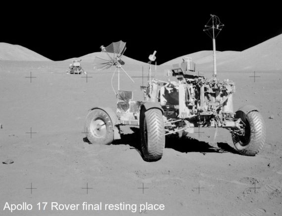
The Washington State Advisory Council on Historic Preservation has unanimously approved the designation of Apollo Lunar Rover Vehicles (LRVs) built by Boeing in Kent, Washington as Washington state historic landmarks.

Apollo 16 exploration site.
Credit: NASA/Washington Heritage Register
The city of Kent and the Kent Downtown Partnership applied to receive historic landmark designation for the LRVs used in Apollo Mission 15 in 1971, and Apollo 16, Apollo 17 in 1972.
At the Boeing Space Center in the 1970s, building 18-23 is where LRV fabrication, manufacturing, and assembly occurred. Building 18-24 is where LRVs were tested.

Apollo 15 rover.
Credit: NASA/Washington Heritage Register
Gone untouched
In documentation supporting the preservation request, it is noted that “the three rovers used in Apollo missions 15, 16, and 17 remain on the lunar surface and have gone untouched since they were last used during their respective assignments.”

LRV fabrication and testing. Credit: City of Kent/Boeing
Furthermore, the document adds: “It should be noted that City of Kent Landmarks Commission designated the three extant Lunar Roving Vehicles as Community Landmarks on July 25, 2019. This Washington Heritage Register application builds on that effort and on the precedent set by California and New Mexico, the first two states to include lunar objects and structures in their state historic registers. Those efforts involved the Apollo 11 Tranquility Base, where more than 100 objects and structures remain from the first human exploration of the lunar surface. In 2010, the California State Historical Resources Commission and the New Mexico Cultural Properties Review Committee voted unanimously to add the many features at Tranquility Base to their respective state registers.”
To view the Washington Heritage Register application – chock full of LRV details – go to:
https://dahp.wa.gov/sites/default/files/documents/nominations/WHR_application_Kent_LRVs_FINAL.pdf

NASA’s Stratospheric Observatory for Infrared Astronomy (SOFIA) is shown airborne with the sliding door over its 17-ton infrared telescope wide open.
Credit: NASA/Jim Ross
Today’s gush of water-on-the-Moon stories is heartening.
But I would be remiss not to underscore a recent NASA Office of Inspector General (OIG) report on NASA’s management of the Stratospheric Observatory for Infrared Astronomy (SOFIA), from which the new lunar observations are predicated:
From the September 14, 2020 OIG report:
“Although responsible for several first-of-its-kind discoveries, SOFIA’s 13-year development delay reduced the Program’s ability to produce impactful science in a cost-effective manner, particularly when compared to the cost of and science produced by other infrared observatories that launched in the interim. Further, SOFIA has not fully utilized its unique capabilities to serve as an instrument test bed due to high instrument development costs, or to fly anytime anywhere because of a lack of instrument scheduling flexibility, the amount of time necessary to switch out instruments, and the prioritization of observations with greater scientific significance.”

In late August 2018, using the high-flying SOFIA and its Faint Object infraRed CAmera for the SOFIA Telescope, observations were made of the lunar surface. Reconnoitered within a 10-minute period was a region at high southern latitudes near Clavius crater. Image taken by NASA’s Lunar Reconnaissance Orbiter (LRO) wide-angle camera image of Clavius crater.
Credit: NASA/GSFC/Arizona State University
Again, just sayin’ – or what am I sayin’?
For the NASA IG report, go to:

Credit: Lunark Habitat mission
Fresh from a Kickstarter campaign, the Lunark Habitat mission is now underway.
Crew members, Sebastian Aristotelis and Karl-Johan, are deep into their three-month journey in the Arctic, Greenland.
Their home-away-from-home design for a lunar dwelling combines the ancient Japanese art of paper folding with the method of biomimicry. The result is a lightweight and strong foldable structure.
“The hab is working well keeping us warm and safe,” reports the twosome. “On average it’s a cozy 22 degrees inside. We feel healthy. Our bodies are adapting to this tiny way of living.”
An earlier communiqué reports: “Went on a long spacewalk up a nearby mountain. Our surroundings are so beautiful. But also barren and vast. It made us feel happy and small.”
Radically different Moon habitat
The project is dubbed “Lunark,” developed by SAGA Space Architects in Copenhagen, Denmark.

Credit: Lunark Habitat mission
Previous research shows that lack of stimuli, isolation, and confinement will become major challenges for the long-term voyages of the future.
This experiment, the architects contend, will develop and test a radically different Moon habitat where architecture helps to counteract monotony, claustrophobia and psychological stress.
For more details on SAGA Space Architects and its Lunark initiative, go to:
Also, go to this informative video at:
Lastly, go to this earlier Inside Outer Space posting on the project at:
https://www.leonarddavid.com/moon-home-to-be-tested-in-greenland/
Thanks to a satellite connection, the castaways send home daily updates that you can follow at:

