Archive for March, 2019

Devon Island offers training ground for future Mars expeditionary crews.
Credit: NASA/HMP
A new partnership has been struck between Google and the NASA Haughton-Mars Project (HMP) on Devon Island, in the High Arctic.
The HMP is a leading international Mars analog field research project centered on the Haughton meteorite impact crater site and surrounding terrain on Devon Island, Nunavut, Canada.
This new partnership “will allow us to share with the world some of the Mars-like wonders of the site and the fieldwork that we do” says Pascal Lee, planetary scientist with the Mars Institute and the SETI Institute, and director of the NASA HMP at NASA Ames Research Center.
Street-wise views!
In August 2018, a team from Google participated in the HMP’s 2018 summer field campaign as a new Education and Public Outreach partner on the project. The main objective for Google at HMP-2018 was to collect Street View imagery to allow Google Earth and Google Maps users to visit Devon Island virtually, and to create a Google Earth guided tour illustrating, via factual narrative, how Devon Island is so similar to Mars.

The Haughton-Mars Project (HMP) Research Station is home for field campaigns of international teams of scientists.
Credit: NASA HMP
Also, a 10-minute documentary titled “Mars On Earth: A Visit to Devon Island” was produced. The video, shot entirely in HD using Google’s latest Pixel 3 smartphone, shows a sampling of the research activities carried out at the HMP over a 10-day period.
Today’s announcement of the new partnership came via The Mars Institute and the SETI Institute. The NASA Haughton-Mars Project is supported by NASA under a Cooperative Agreement with the SETI Institute.
Resources
The Google documentary — Mars On Earth: A Visit to Devon Island – can be viewed at:
For a Google Earth Guided Tour, Mars on Earth, go to:
https://g.co/earth/devonisland
For Google Street View highlights, go to:
Link 1: Astronaut Canyon
Link 2: Haughton Crater at View Hill
Link 3: Haughton-Mars Project Base Camp
Link 4: Von Braun Planitia: An Ancient Lake Bed
Link 5: Haughton Crater at Breccia Cliffs

NASA’s Lunar Reconnaissance Orbiter’s (LRO) camera system has pieced together this impressive farside photo projection.
Credit: NASA/GSFC/Arizona State University
There’s a growing call to protect the Moon’s farside, to guard this unique real estate.
Future space planners “need to think ahead and preserve the precious space resources that still remain unpolluted by humankind,” explains Claudio Maccone of the International Academy of Astronautics and Istituto Nazionale di Astrofisica in Italy.
“For this reason, we want to protect the lunar farside,” Maccone adds, “which is ideal for a future radio telescope or phased array detectors, from any human-made radio pollution.”

Protected Antipode Circle, is the circular piece of land proposed to be reserved for scientific purposes only on the farside of the Moon.
Credit: Claudio Maccone
Radio-noise-free environment
This week, an International Academy of Astronautics (IAA) symposium is being held in Paris on “Lunar Farside 2019.” Spearheaded by Maccone, he will outline twenty years of IAA studies to protect the Moon farside radio-noise-free environment.
The lunar farside is where radio transmissions and noises produced by humanity on Earth may not reach since the spherical body of the Moon blocks them, acting like a shield.
“Unfortunately, the undeclared but quite real ‘current, new race to the Moon’ complicates matters terribly,” Maccone says.
“All the spacefaring nations now keep their eyes on the Moon, and only the United Nations might have a sufficient authority to protect the farside and keep safe its unique ‘radio-noise-free’ environment,” Maccone says. “But time is money, and the ‘Moon Settlers’ may well reach the Moon before the United Nations come to agree about any official decision concerning the farside protection.”

Vision of the Moon’s farside with the Daedalus Crater base for RFI-free radio astronomy, Astrobiology and SETI science. Future International Space Stations might be located at both the L4 and L5 Earth-Moon Points in the decades to come. Only Point L2 will have to be kept free at all times.
Credit: Claudio Maccone
Real estate protection
Earlier this year, Maccone’s concerns and views were expressed in a paper — Moon Farside Protection, Moon Village and PAC (Protected Antipode Circle) – published in the January 2019 issues of the journal, Acta Astronautica.
The paper defines a Protected Antipode Circle (PAC), a circular piece of real estate on the Moon’s farside that measures roughly 1,130 miles (1,820 kilometers) in diameter. Also proposed is that the projected “Moon Village” espoused by the European Space Agency’s Director General, Jan Wörner, be located outside the PAC.
A PAC prevents interfering with detection of radiation coming from space. Also south of the PAC is “close” to the lunar South Pole and access to frozen water there. “It thus appears that the best venue for the ‘Moon Village’ would be on or around the 180 meridian and possibly quite close to the South Pole,” Maccone asserts.

This cone is the portion of space above the Farside of the Moon that will never be reached by these electromagnetic waves. Thus, it is appropriately called quiet cone, where “quiet” means “radio silent”.
Commercial wars
The paper proposes location of the first Radio Frequency Interference-free site in the crater Daedalus, the most shielded crater of all on the Moon’s farside from Earth-made radio pollution.
From that RFI-free site, astronomy, astrobiology and search for extraterrestrial intelligence (SETI) science can be carried out, Maccone explains.
Maccone also claims that the time will come when “commercial wars” among the big industrial trusts running the telecommunications business by satellites will lead them to grab more and more space around the Earth, pushing their satellites into orbits with apogee much higher than the geostationary one. Therefore a “safe” crater must be selected on the Farside along the Moon equator, he contends.

Proposal: to establish the first RFI-free base on the Moon just inside crater Daedalus, the most shielded crater of all on the Moon’s farside from Earth-made radio pollution.
Credit: NASA/Apollo 11 photo
Blinder and blinder
The mission of Maccone is to make individuals sensitive to the importance of protecting the central farside of the Moon “from any future wild, anti-scientific exploitation,” he says.
“The Farside of the Moon is a unique place for us in the whole universe: it is close to the Earth, but protected from the radio emissions that we ourselves are creating in an ever increasing amount and that is making our radio telescopes blinder and blinder.”
To view the paper — Moon Farside Protection, Moon Village and PAC (Protected Antipode Circle) – go to:
https://www.sciencedirect.com/science/article/pii/S0094576517316478

Proposed cis-lunar Gateway.
Credit: Lockheed Martin
Work is progressing on fleshing out designs and capabilities of a new habitable structure near the Moon, known as the Gateway.

International partners for the proposed cis-lunar Gateway.
Credit: ESA
Late last year, the European Space Agency (ESA) commissioned two consortia – one led by Airbus and the other by Thales Alenia Space – to undertake parallel studies into the design of a scientific airlock.
Similar to the Japanese Experiment Module Kibo on the International Space Station, this airlock will allow scientific experiments to be transferred from the Gateway to and from outer space.

A possible design for a scientific airlock that could form part of Europe’s ESPRIT module on the Gateway is lowered into a test pool by members of an Airbus-led consortium in Marseilles, France.
Credit: ESA
Underwater mockup
The scientific airlock forms one part of a European module called ESPRIT – a module that will also enable refuelling and provide telecommunications with the Moon and Earth.

Underwater testing of a concept for the scientific airlock which will form part of Europe’s ESPRIT module for the Gateway – a new habitable outpost near the Moon.
Credit: Arnauld Probst
Designed and constructed by French company Comex for Airbus, the mockup of ESPRIT’s interior was recently tested underwater to simulate the weightlessness of space. The underwater appraisal was meant to confirm a preliminary inner design and identify the best place to put handrails to ensure optimal stability of the crew as they carry out payload handling and airlock operations.
At this stage both companies will be asked to present their concepts and costings for consideration ahead of ESA’s next Ministerial Council in November.
The Lockheed Martin Habitat Ground Test Article (HGTA) Lunar habitat prototype is designed to accommodate a variety of missions around the Moon.
Credit: Lockheed Martin
Prototype cislunar habitat
Meanwhile, under a public-private partnership as a part of NASA’s Next Space Technologies for Exploration Partnerships (NextSTEP) Phase II study contract, Lockheed Martin has completed the initial ground prototype for a cislunar habitat.
The full-scale prototype, or Habitat Ground Test Article, is built inside of a repurposed shuttle-era cargo container, called a Multi-Purpose Logistics Module, at Kennedy Space Center.
Lockheed Martin will soon transition the prototype to the NASA NextSTEP team for assessment.

Inside look at prototype cis-lunar Gateway.
Credit: Lockheed Martin
Astronaut feedback
During the upcoming week of March 25, a team of NASA astronauts will live and work inside the prototype, evaluating the layout and providing feedback. The NASA test team will also validate the overall design and will be able to evaluate the standards and common interfaces, like the International Docking System Standard, and how to apply those systems for long-term missions based at the Lunar Gateway.
Once NASA testing has completed, Lockheed Martin will continue to optimize and study the prototype to prepare for other lunar efforts, according to a company press statement.

Curiosity Front Hazcam Right B image acquired on Sol 2355, March 22, 2019.
Credit: NASA/JPL-Caltech
NASA’s Curiosity Mars rover is now performing Sol 2356 science tasks.
Meanwhile, a new Curiosity traverse map has been issued by the Jet Propulsion Laboratory, showing the robot’s mobility through Sol 2354 (March 22).

Credit: NASA/JPL-Caltech/Univ. of Arizona
Numbering of the dots along the line indicate the sol number of each drive. North is up. The scale bar is 1 kilometer (~0.62 mile).
From Sol 2352 to Sol 2354, Curiosity had driven a straight line distance of about 78.32 feet (23.87 meters), bringing the rover’s total odometry for the mission to 12.62 miles (20.32 kilometers).
The rover landed on Mars in August 2012.
The base image from the map is from the High Resolution Imaging Science Experiment Camera (HiRISE) in NASA’s Mars Reconnaissance Orbiter.

Curiosity Navcam Right B image taken on Sol 2355, March 22, 2019.
Credit: NASA/JPL-Caltech

Curiosity Navcam Right B image taken on Sol 2355, March 22, 2019.
Credit: NASA/JPL-Caltech

Curiosity Navcam Left B image acquired on Sol 2355, March 22, 2019.
Credit: NASA/JPL-Caltech

Image shows exceptionally bright meteor that exploded over the Bering Sea on Dec. 18, 2018. The shadow of the meteor’s trail through Earth’s atmosphere can be seen, imaged by an instrument on NASA’s Terra spacecraft.
Credit: NASA/GSFC/LaRC/JPL-Caltech, MISR Team
A December 2018 fireball that zipped through the Earth’s atmosphere exploded about 16 miles (26 kilometers) high above the Bering Sea, unleashing an estimated 173 kilotons of energy. That’s a significant happening.
This incoming object was captured by a NASA satellite. Two NASA instruments aboard the multi-national Terra scientific research satellite spotted the fireball fly-in a few minutes after the event.
Cloud top trail
Images show the shadow of the meteor’s trail through Earth’s atmosphere, cast on the cloud tops and elongated by the low sun angle to the northwest. The orange-tinted cloud that the fireball left behind stems from super-heating the air as the meteor passed through.
According to NASA experts, the December 18 fireball was the most powerful meteor to be observed since 2013; however, given its altitude and the remote area over which it occurred, the object posed no threat to anyone on the ground.

Wake-up call: The 2013 incoming space rock over Chelyabinsk, Russia.
Credit: Alex Alishevskikh
City destruction
“Although the fireball was the second largest impact on Earth recorded in the last century, it still was too small to cause any significant damage, fortunately,” said Andrew Cheng of the Applied Physics Laboratory (APL) in Laurel, Maryland.
The Chelyabinsk meteor in 2013 that detonated over Russia was not much larger (about 20 meters) but damaged thousands of buildings and injured over 1,000 people.
“But an impactor only 100 meters across, if an asteroid that large were to hit a populated area, would be a disaster. Such an impact could destroy an entire city and its surrounding area,” Cheng told Inside Outer Space.

Artist concept of NASA’s Double Asteroid Redirection Test (DART) spacecraft. DART, which is moving to preliminary design phase, would be NASA’s first mission to demonstrate an asteroid deflection technique for planetary defense.
Credits: NASA/JHUAPL
Kinetic impact
Cheng is working on the Double Asteroid Redirection Test (DART), and offers some planetary defense counsel.
“So these fireball events are wake-up calls, and NASA has responded. NASA has approved its first planetary defense mission, which is DART. This mission will demonstrate the kinetic impact technique for deflecting an asteroid, by hitting it with a spacecraft to change its orbit,” Cheng explains.
DART will perform the kinetic impact demonstration at the 525-feet (160-meters) moon of the binary asteroid Didymos in late September-early October, 2022.
NASA is imminently going to announce the launch vehicle selection for DART.
For more information on this event, go to my new Scientific American story at:
Huge Meteor Explosion a Wake-Up Call for Planetary Defense – Detonating over the Bering Sea

Chang’e-4 lander and Yutu-2 rover. Images of each other taken by the respective machinery.
Credit: CNAS/CLEP
The super-camera system on NASA’s Lunar Reconnaissance Orbiter (LRO) continues to monitor the whereabouts and wanderings of China’s Yutu-2 rover on the Moon’s farside.

The Chang’e 4 rover, Yutu-2, moved between February 1, 2019 and February 28, 2019. The upper left panel shows the landing site before Chang’e-4 set down and the image in upper right panel has the best resolution of the lander and rover taken so far. The lower left image was taken six hours later with a slew angle of 40°. The most recent view in the lower right shows that Yutu-2 traversed 150 feet (46 meters) to the west during the month of February.
Credit: NASA/GSFC/Arizona State University
Over the next few months, the Sun will rise higher and higher over the landing site when LRO is overhead, providing the opportunity to obtain images with no shadows, according to Mark Robinson, principal investigator of LRO’s Lunar Reconnaissance Orbiter Camera (LROC) system — three cameras mounted on the LRO that capture high resolution photos of the lunar surface.
Blast zone
Those upcoming images will be particularly useful for mapping differences in brightness (albedo), Robinson notes, and researchers should get the first real look at the “blast zone”- the region that was brightened around the Chang’e-4 lander as rocket exhaust interacted with the regolith, as seen around all other landing sites.
The tracks of the rover should also be visible in the coming months, allowing researchers to follow Yutu-2’s exact path along the floor of Von Kármán crater during its exploration of the lunar farside, Robinson explains.

NASA’s Lunar Reconnaissance Orbiter (LRO).
Credit: NASA/Goddard Science Visualization Studio (SVS)
China’s Chang’e-4 mission landed in Von Kármán crater within the South Pole-Aitken Basin on January 3, 2019.
Westward progress
LRO passes over any given place on the Moon at least once every month (in the daylight), allowing the westward progress of the Yutu-2 rover to be seen.
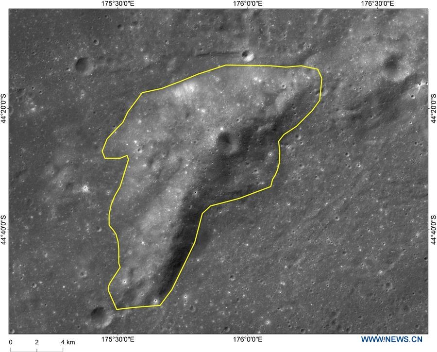
Image of Mons Tai, a hill near “Statio Tianhe”, the landing site of China’s Chang’e-4 lunar probe.
Credit: CNSA
Robinson explains that, at the end of February, Yutu-2 was 226 feet (69 meters) from its home base, the Chang’e-4 lander; LROC images show Yutu-2 made 150 feet (46 meters) of westward progress during the month of February.
Each month when LRO images the landing site, now called Statio Tianhe, the lighting changes, providing a different view of the surface.
During times near dawn or dusk, Robinson says, long shadows enhance topography and closer to noon differences in surface brightness are more apparent. In the latest image from February 28, the Sun is near the horizon and the lander and rover each cast long shadows.

Credit: ESA – P.Carril
THE WOODLANDS, Texas – The Earth was on the receiving end of a little-noticed intruder back in late 2018. A hefty space rock detonated over an isolated stretch of the Bering Sea, between Russia and Alaska.
The blast occurred at roughly 16 miles above the ocean, yielding an energetic, high-altitude punch judged to be 40 percent the energy release of the destructive February 2013 meteor blast over Chelyabinsk, Russia.
This late news bombshell was unveiled here by Kelly Fast, NASA’s Near-Earth Object Observations program manager, during a media briefing on NASA’s planetary defense programs prior to the start of this week’s 50th Lunar and Planetary Science Conference.
For more details, go to my new Scientific American story:
Huge Meteor Explosion a Wake-Up Call for Planetary Defense
Detonating over the Bering Sea, the blast was as powerful as a nuclear bomb

Credit: IBMP
Russia’s SIRIUS (Scientific International Research in Unique Terrestrial Station) experiment is now underway and simulating a flight to the Moon.

The SIRIUS crew headed for the Moon: From left to right: Reinhold Povilaitis (USA), Daria Zhidova (Russia), Commander Yevgeny Tarelkin (Russia), Anastasia Stepanova (Russia), Allen Mirkadyrov (USA)
and Stephania Fedeye (Russia). Credit: IBMP
Six members of the international SIRIUS crew started a 120-day experiment to simulate the flight to the Moon at Moscow’s Institute of Biomedical Problems (IBMP) on Tuesday.
Cosmonaut commander
The SIRIUS-19 experiment is being conducted under the command of 44-year-old Russian cosmonaut Evgeny Tarelkin, who has already carried out one space mission. Tarelkin crewmates are Reinhold Povilaitis, Allen Mirkadyrov (both U.S.), Daria Zhidova, Anastasia Stepanova and Stephania Fedeye (all Russian).

Credit: DLR
U.S. representatives
Two U.S. representatives are taking part in the experiment: Reinhold Povilaitis, an analyst of research and operations on NASA’s Lunar Reconnaissance Orbiter (LRO) and Allen Mirkadyrov in Telecommunication Networks and Technologies of NASA’s Goddard Space Flight Center.
Christian Rogon is SIRIUS Project Manager at the German Aerospace Center (Deutsches Zentrum für Luft- und Raumfahrt; DLR) Space Administration. DLR is participating in the SIRIUS-19 isolation study together with the French space agency (CNES) under the leadership of the Russian space agency Roscosmos and NASA.
Moon visit

Credit: DLR
In addition to the numerous experiments and the many everyday challenges, one very special highlight awaits the crew – a visit to the Moon.
“Exactly halfway through the SIRIUS isolation study, four ‘cosmonauts’ will land on the lunar surface in a small capsule,” DLR’s Rogon explains. “Once there, they will carry out several ‘Moon walks’ while wearing spacesuits, collect samples and prepare a ‘settlement’ on the Moon – a very special experience.”
Two ‘cosmonauts’ will stay behind in the orbital lunar station and monitor the excursion. After the return and successful docking of the lander with the station, the whole crew will orbit the Moon together for another 30 days. During this time, they will remotely control rovers on the lunar surface, dock more spaceships with the orbital station, and carry out numerous experiments before returning to Moscow, notes a DLR statement on SIRIUS-19.
NASA/IBMP collaboration
NASA and the State Research Center Institute for Biomedical Problems of the Russian Academy of Sciences (IBMP) have a long and successful history of collaborating on joint research related to human health and well-being in space.
NASA’s HRP (Human Research Program), and IBMP are conducting research to identify preventive measures and technologies to protect the health of astronauts and astronauts during space flight.

Curiosity Front Hazcam Right B photo taken on Sol 2353, March 20, 2019.
Credit: NASA/JPL-Caltech
NASA’s Curiosity Mars rover is now performing Sol 2353 duties.
Curiosity has made the drive to a rock called “Muir of Ord,” which has a cracked surface, reports Dawn Sumner, a planetary geologist at the University of California Davis in Davis, California. The network of cracks in this Martian rock slab called “Old Soaker” may have formed from the drying of a mud layer more than 3 billion years ago.

“Muir of Ord,” which has a cracked surface. Curiosity Front Hazcam Left B image acquired on Sol 2352, March 19, 2019.
Credit: NASA/JPL-Caltech
“The science team is particularly interested in imaging this rock up close because of the fracture patterns. Cracks like these can form from mud drying out when the original sediments were deposited or after exposure of the rock during weathering,” Sumner adds.
If the cracks on Muir of Ord formed when the sediment was first deposited, they tell Mars scientists something about the depositional environment. If they formed during weathering, that informs researchers about the processes on the slopes of Mount Sharp.

Curiosity Mastcam Right photo taken on Sol 2351, March 18, 2019.
Credit: NASA/JPL-Caltech/MSSS
Planned observations by the rover should help determine which is more likely.
Elemental composition
A recent Curiosity science plan starts with contact science on the “Crieff” target, which is on the top surface of Muir of Ord. The rover’s Alpha Particle X-Ray Spectrometer (APXS) was slated to perform a short analysis to determine its elemental composition, and the Mars Hand Lens Imager (MAHLI) will image it at progressively higher magnifications. Doing so allows scientists to study the crack shapes in detail.

Curiosity Mars Hand Lens Imager (MAHLI) photo produced on Sol 2352, March 19, 2019.
Credit: NASA/JPL-Caltech/MSSS
MAHLI will then image the side of Muir of Ord at a target called “Crossroads” to see how the cracks cross the layering in the rock. Once the contact science is complete, the robot’s Chemistry and Camera (ChemCam) will analyze Crieff with a 3×3 grid, and Mastcam will take a mosaic of Muir of Ord.
ChemCam was then set to analyze the targets “James,” “Kilmarnock,” and “Crail” with Mastcam providing context images. Finally, Curiosity will finish up the science at this spot with two more Mastcams of “Aldons Quarry” and “Small Isles.”
New rover drive
The next activity is a roughly 100 foot (30 meters) drive with sequential Mars Descent Imager (MARDI) images to document the large-scale fracture patterns in the outcrop. Once the drive is over, Curiosity’s to-do list includes taking typical post drive images, including both Navcam and Mastcam mosaics of the workspace and the future drive direction.
The second sol of a recently scripted plan includes lots of environmental measurements, Sumner adds. “The morning activities consist of Mastcam imaging of the sun to characterize dust in the atmosphere, a Navcam movie above the horizon to study atmospheric dynamics, and a Navcam movie looking for dust devils.

Curiosity Navcam Right B image taken on Sol 2352, March 19, 2019.
Credit: NASA/JPL-Caltech

Curiosity Navcam Left B image taken on Sol 2352, March 19, 2019.
Credit: NASA/JPL-Caltech
Afternoon activities include a zenith movie to image clouds and their motion, plus a second set of sun images. Geological activities include an Autonomous Exploration for Gathering Increased Science (AEGIS), that is, use of the novel autonomy software to analyze a rover-selected target as well as a Mastcam 360° panorama.
“We are looking forward to interpreting all this great new data,” Sumner concludes.

This trio of images acquired by NASA’s OSIRIS-REx spacecraft shows a wide shot and two close-ups of a region in asteroid Bennu’s northern hemisphere.
The wide-angle image (left), obtained by the spacecraft’s MapCam camera, shows a 590-foot (180-meter) wide area with many rocks, including some large boulders, and a “pond” of regolith that is mostly devoid of large rocks.
The two closer images, obtained by the high-resolution PolyCam camera, show details of areas in the MapCam image, specifically a 50-foot (15 meter) boulder (top) and the regolith pond (bottom). The PolyCam frames are 101 feet (31 meters) across and the boulder depicted is approximately the same size as a humpback whale.
The images were taken on February 25 while the spacecraft was in orbit around Bennu, approximately 1.1 miles (1.8 km) from the asteroid’s surface.
The observation plan for this day provided for one MapCam and two PolyCam images every 10 minutes, allowing for this combination of context and detail of Bennu’s surface.
Date Taken: Feb. 25, 2019
Instrument Used: OCAMS (MapCam and PolyCam)
Credit: NASA/Goddard/University of Arizona

